Follow the directions to reach the Man Stone carving. Walk up the sloping hillside from there until you reach the top. From there, walk down the slope heading slightly to your left. You’ll find it!
Archaeology & History
A small upright stone, less than three feet tall, but once a little taller as you’ll see that it’s head has been knocked off in the not-too-distant future and lies on the ground by its side. A small scatter of what seems like possible cairn-material lies around its base, but not enough to imply that a tomb of any sort was ever here (aswell as that, the position on the slope seems wrong).
A curious little thing, without archaeological companions. When we came here the other day, we explored the ground all round the stone as all the heather had been burnt back; but there was nothing anywhere near it to give a hint as to why it stands here, alone, at what seems like a strange spot two-thirds the way up a moorland slope. It’s been speculated that in the middle of its more north-facing side there is a cup-mark on it, but this is very dubious and, in my opinion, should be discounted as such. The marking is a gun-shot wound – and more recent ones have just been added, as seen in the photo.
Dead easy! From the townships of Grasscroft, Uppermill, or Greenfield, take the legendary moorland road up to Saddleworth tops (A635), keeping your eye on the modern obelisk on the hilltop to your left and you’ll see a large rock outcrop almost next to it. That’s where you’re heading. Once you reach near the moorland level, walk in whatever way you see fit towards the obelisk and large stones. Enjoy…! I s’ppose though, it’d be better for you if you started from the valley bottom at Uppermill and walked up the hill.
Folklore
Seemingly a ritual place of the sun, this fine site was known by the local folk-name of the Druid Stones, according to Jessica Lofthouse. (1976) But more importantly in legend, this great rocky outcrop was the abode of an old giant called Alphin, who had a rival called Alder who also wandered the moors here. Both these giants vied for the hand of a lady called Rimmon, who preferred Alphin to Alder. In good old fashioned ways they contested for her hand, throwing giant rocks across the moors at each other, but “Alphin was hit and killed, with Rimmon looking on.” His grave lies on these moors somewhere, seemingly unfound. …And intriguingly it seems that we’ve actually located a prehistoric tomb which may account for the legend of Alphin’s death! (Watch this space!)
A slight variation on the tale describes the Lady Rimmon to be of fairy stock, named ‘Raura Peena’ (a phonetic spelling of a local dialect name), who in one account from the Notes & Queries journal, 1850, tried luring a local man into her magickal recess of the Fairy Holes, on the slopes beneath the Pots and Pans Stone.
Local tradition also tells that the naturally-worn ‘bowls’ atop of the rocks held magical properties — water being collected from them was said to be good to cure eye problems. This is a curative theme we find at some bullauns, cup-marked stones and old cross-bases and would strongly indicates that pre-christian practices did once take place here.
References:
Lofthouse, Jessica, North Country Folklore, Robert Hale: London 1976.
Standing Stone (destroyed): OS Grid Reference – SE 299 612
Also Known as:
Temple Yarmer
Archaeology & History
It was the legendary Harry Speight who described this in his monumental historico-topographical exploration of the Nidd valley in the 1890s. Nothing else, it seems, has been said of the place, though something of considerable archaeological importance was once here. Not only does he tell of the previous existence of “a large circular enclosure…the outer ditch having a circumference of nearly 1000 yards” at Yarmer Head, but,
“In the hollow on the east side of this hill was formerly a large natural marsh or lakelet, near which remains the base of an immense menhir or standing monolith, erected doubtless in heathen days to commemorate a great victory, or perhaps a treaty.”
The stone is not shown on the early OS-maps (although they did miss quite a lot of sites), and whatever its reason for being here might never be known as all traces of this giant monolith appears (yet again) to have vanished. There is an ancient boundary line immediately below the hill, on its eastern side, so perhaps the stone was an ancient marker along this. Do any local folk round Nidd know owt more about this once important megalithic site?
References:
Speight, Harry, Nidderdale and the Garden of the Nidd, Elliot Stock: London 1894.
Follow the same directions as to reach Holden’s Buttock Stone, then north over the field and through the gate towards the Rough Holden Carving. As you approach here, keep your eyes peeled for a clump of boulders a little further down the field which stand out. That’s where you wanna be!
Archaeology & History
Found by the old Keighley volunteer, Michala Potts of Bracken Bank, a few weeks back (Friday, June 12, 2009), this previously undiscovered cup-marked boulder is amidst a scatter of boulders piled-up with each other following a field-clearance in recent years. It doesn’t seem to be in its original position, but obviously came from the fields hereby.
Side view of cup-marks
The first view we got indicated 2 or 3 cup-markings on its upper surface; but then as we wandered round it and the adjacent rocks, it seemed that several others appear to have been etched on the vertical face, as shown in one of the photos. The light wasn’t too good by the time we found this (it was one of those days where cloud and sun kept the cup-marks hidden at times!) and then a drizzle came along and stopped a sketch of the stone. But it’s obvious there are 3-4 cup-markings on the upper surface and at least 3 carved on its side. Next time up there we’ll hopefully get better light!
One of the land-owners or tenant farmers hereby has little respect for the prehistoric remains in this area and, in all honesty, I’d expect a number of the petroglyphs to be destroyed in the coming years.
Various ways up this old hill, visible from all angles it seems. I came up via the housing estate near where us friend lives, near Bare Lane Station, through the houses and up the footpath. But you can just as easy (if not easier) walk up from the country lane and fields beneath its eastern side. Much nicer!
Archaeology & History
Torrisholme Barrow
As many northerners will tell: gerrin information from the Lancashire archaeologists about prehistoric sites is troublesome (must be Southerners running the show!). There’s tons of stuff in this good county, but archaeo-info is pretty poor on the ground. This great old tomb for example, is designated as a “round barrow” on the Lancashire County Council monuments and records listing, but there’s no other info telling when it was dug, who by, the size of the tomb, what was found here, etc. Pretty poor to be honest (c’mon chaps – get yer fingers out!). The best info on-line comes from the more dedicated amateur enthusiasts.
A local historian told us that there was nowt up here, but my nose told me otherwise — so up we tramped! It was pretty obvious once we’d got to the top here, that some ancient mound had been built up.
“This has all the hallmarks of a tomb,” I said.
Torrisholme Barrow, looking SW
The spirit of the ancestor herein (whoever s/he was) had excellent views and flights to numerous important hills 360° all round here. A perfect place for a tomb! And when we returned into the Darklands of our Yorkshire abodes, we found this notion to be true. Marked on early OS-maps as a tumulus, next to the tell-tale giveaway route of Barrow Lane, there are passing mentions of it in a couple of old local history books I’ve come across, but I’ve yet to find much more about it. It’s a fine mound and of decent size, well worth checking out if you’re in the area. Once I get more details of the archaeological finds from here, I’ll add the data to TNA (but based on past performances and responses from Lancashire archaeo’s, I wouldn’t hold your breath…)
And for any Morecambe historians who might be able to find more: what — if anything — is known of the ‘Fartle Barrow’, now swallowed by the encroachment of the sea, just a few hundred yards west of here?
Folklore
In days of olde, this site was an old moot or meeting hill: one of the northern Law or council meeting hills. Quite how far back this gathering tradition up here goes, aint known. We do know however that there was a christian tradition enacted here, at Easter, of local church doods taking a cross up the top of the hill (does anyone know the story behind the old Cross Hill, half-a-mile south of here?). There’s obviously quite a lot more pre-christian activities occurrent round here than has been previously thought.
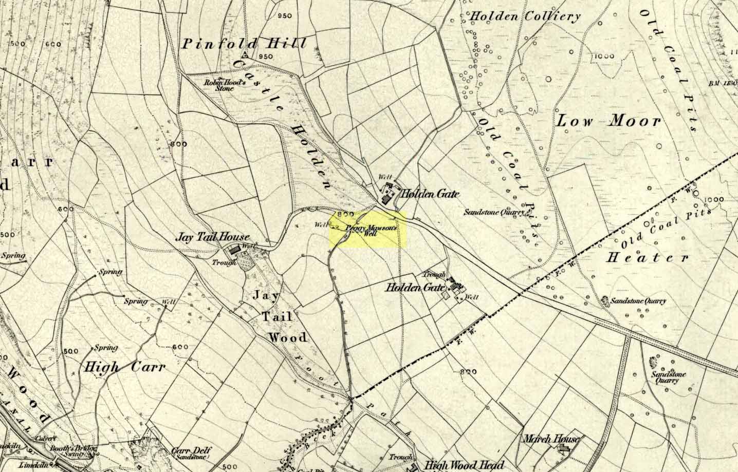
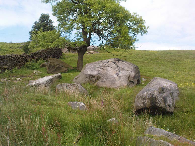
Dead easy! If you come from Silsden, take the Holden Road up onto the moor edge, all the way up the wooded hill. As you reach the top, keep your eyes peeled for the stone in the slope to your left. Otherwise, coming from Riddlesden, take the moor road upwards (to Silsden Road) as if you’re gonna visit Peggy Mawson’s Well, the Baldwin Stone or some of the Rivock carvings. Keep on the road to where you see the microwave tower on Pinfold Hill to your right. It’s just below it!
Archaeology & History
Robin Hood’s Stone from above
Flints have been found on the slopes above here, but records of this stone only go back — as far as I’ve found — to 1850 (this seems to typify records around the Keighley district, which only seems to record anything post-1500 AD). In mid-Victorian times, plans were afoot to use the rock for building material, but local people objected and so the stone kept its position overlooking the valley. There are a number of very defined ‘cups’ on the sloping face of the stone, but several (though not all) of these have all the likeness of the holes dug into the rock by climbers — though why climbers would even think to cut foot-holes into this easy rock beggars belief!
Folklore
One of several sharp well-defined ‘cups’ on the rock
Not too surprisingly, folklore tells that this stone was one of the places where our old hero Robin Hood sheltered, when being chased by god-knows-who in one of his many exploits. We’ve no way of proving this of course, but the sparse woodland remains above here also bear the hero’s name. What seems to be a more modern piece of industrial folklore alleges that this stone was actually put here by workers in the Victorian times! The boulder allegedly lived near Barden, Bolton Abbey, but was blocking construction work, so was uprooted and moved all the way to where it now sits! In bygone times the rock was a local meeting place – perhaps around Beltane, in line with Robin Hood festivities.
References:
Gray, Johnnie, Through Airedale from Goole to Malham, Elliot Stock: London 1891.
From Riddlesden, take the road up to the moorland and Rivock Edge. When you reach the top (Silsden Road), turn left. Go on for about 600 yards till you reach the lovely tree-hidden old cottages of Holden Gate, on your right. Stop — and walk down the footpath opposite from here. As the wall goes down, you’ll notice a stream in the next field to your left, emerging from a clump of large rocks. That’s it! (there’s a footpath in the next field from the roadside)
Archaeology & History
Shown on the first OS-map as ‘Peggy Mawson’s Well,’ little else seems to known of this place; though it obviously got its name after the local lady, Peggy Mawson. I can find no further information about this lady, nor why the site was named after her. Any help here would be hugely appreciated!
Peggy Mawson’s Well – now drained-off through pipes
Sadly the waters from beneath the rocks have been channeled into a couple of pipes and the well no longer runs. All that’s left is a small boggy region just in front of the boulders. You have to walk about 100 yards further down the field where the water emerges from a modern pipe. It doesn’t taste as nice as it originally did when coming straight from the ground, but it’s still quite drinkable (certainly beats any of the chlorinated stuff* that customers are forced to pay for, whether we want it or not – and most people don’t want it).
Folklore
This site has acquired modern folklore, but sadly no early traditions have been found. Whelan & Taylor (1989) thought that Peggy Well’s “dedication suggests a connection with St. Margaret,” which unfortunately isn’t the case. Several years later another writer, Val Shepherd (1994), spun the speculation even further, not checking the historical background to the site, and thought that “the well’s name may be derived from the water spirit, ‘Peg,’ who gave her name to other wells.” Sadly neither idea holds any sway.
References:
Shepherd, Val, Historic Wells in and Around Bradford, HOAP: Loughborough 1994.
Whelan, Edna & Taylor, Ian, Yorkshire Holy Wells and Sacred Springs, Northern Lights: Pocklington 1989.
* Anyone know about this: surely because the water companies chlorinate and add other undesirable toxins into our tap water, what we’re actually drinking is a very weak solution and not actually water. Isn’t that a trading standards violation?
Follow the same directions to reach the Robin Hood’s Wood Stone, but head from there to the dirt-track about 30 yards away. This stone is just 10-15 yards on the south-side near the bend in the track. Look around!
Archaeology & History
Holden Cup-Marked Rock
If you can find this stone, the 2-cupped Robin Hood’s Wood Stone carving is only about 15 yards SW. But this poor example is a mere single cup-mark sitting near the centre of a large flat rock, half-covered in vegetation like its nearby compatriot. There’s a faint possibility of a second cup-mark on the rock, but it’s pushing it a bit! Thanks to the vegetation cover on the majority of the rock, the cup’s in a good state of preservation. Nowt much to shout about unless you’re a real cup-and-ring nut!
Follow the same directions for reaching the Baldwin Stone. From here, with your back to the wall, face the small remnants of Robin Hood’s Wood and walk straight to where the game-keeper’s stuff is in the trees 150 yards straight in front. Go through the small copse and out the other side, in a straight line for another 70 yards. This stone’s mainly covered over with vegetation (and we covered most of it back over again) so you might have trouble finding it. But with patience and a good nose, you’ll find it hereabouts!
Archaeology & History
Robin Hood’s Wood Cup-Marks
Another previously undiscovered carving, found yesterday (12.6.09) by Michala Potts after rummaging for sometime amidst the mass of Juncus grasses which cover the plain immediately north of Robin Hood’s Wood. Not much to see unless you’re a real rock-art freak, as we only have two definite cup-markings on the stone. A possible third cup can be seen closer to the NW edge, where the rock becomes more crystalline.
I was rather intrigued by Mikki’s find, as when she shouted me over, found that she’d rolled much of the vegetation back that had been covering the stone. Without rolling the grasses back from the surface, she wouldn’t have found the cup-marks; and considering the number of stones that scatter this plain, I asked why she’d chosen to uncover this one and not the others.
“It told me to!” she said in that blunt Yorkshire way.
Another carving that might take a bitta finding. Follow the same directions for reaching the Holden Buttock Stone, going past it towards the fence 100 yards away. Go through the gate and walk along the path for a couple of hundred yards. As you walk down, you’ll eventually see the cluster of rocks amidst which lives the Dump Stone carving. This, the Rough Holden cup-and-ring, is off the path (right) before you get to them in the grasses. Look around.
Archaeology & History
Rediscovered in June 2009 by Michala Potts and I, this little stone at first only appeared to possess a few cup-markings, but the more we looked at it, the more obvious it became that one of the cups had a nice ring surrounding it. Unfortunately this didn’t come out at all well in any of the photos we took, so we need to another visit here whe the sunlight’s right to get a decent image. Aswell as that, the drawing we did of the basic design appears to be missing what looks another blatant cup-marking near the centre of the rock, which did not seem at all obvious to the naked eye when we found it. (such are the delights of assessing cup&rings!)
Rough Holden cup-marksBasic sketch of the stone
The main cluster of cups occurs on the northern-edge of the stone, where a couple of them seem linked by linear features. There are also what may be a cup or three on the vertical edge of the rock, below these cups – but this needs looking at again the better lighting. The cup-and-ring is very faint, but once noticed it become increasingly obvious that it’s there, and most of the ring can be traced with ease by running one’s finger along the groove. Mikki reckons the ring runs all the way round the cup (she’s probably right), where as I could only work it out running 75% of the way round. The line which runs off above the ring seems to link up with what looks like another obvious cup-marking on the photo. We’ll have to check it out properly next time we’re up there!