To get here, follow the same directions as if you’re going to the Morphing Stone. This carving is in the same field, but about 100 yards SSW of there, just to the south-side of the Nidderdale Way footpath. There’s plenty of rocks about, but with a bit of patience or a natural rock-art dowser’s nose, you’ll find the carving easily enough!
This is another relatively recent find — though I wonder whether the nearby ‘Fertility Stone’ (about 500 yards north, in some walling) should switch names with this carving, as this one gives the distinct impression of sperm fertilizing the egg! Don’t you agree!? The name of the Tadpole Stone was given to it by Michala Potts — and the photograph and design are used, courtesy of Richard Stroud. In the next field from here, towards Eastwoods Farm, we find the Eastwoods Cross base and cup-markings and adjacent cup-marked stone. Not far away are other carvings, aswell as a number of other Bronze- and Iron-Age sites.
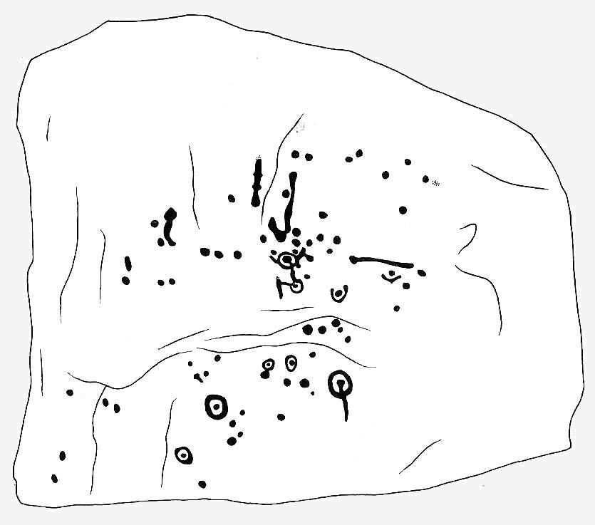
This design was described in Keith Boughey’s (2007) article on the rock art around Eastwoods Farm, telling how it
“was discovered by Kevin Cale and reported to the N.Y.C.C. SMR back in 2001… A low profile moss-covered earthfast rock a little over 1m in diameter in any one direction immediately S of the Nidderdale Way about 100m east of the end of Monk Ing Road and S of Eastwoods Farm at SE 18601 61643 and 172m O.D. Its domed surface carries a somewhat unusual design interestingly reminiscent of the design carved at the previous site which lies in the same field and landscape 160m to the north-west… An oval or egg-shaped groove enclosed up to six cups; a groove or channel, often referred to as a ‘comet tail’ in rock art motif vocabulary, runs from the central group of the six out beyond the enclosing groove, bends sharply and continues down over the sloping face of the rock. A wide groove at the base of the rock running into the present turf line may be a further element of the carving.”
References:
Boughey, K., “Prehistoric Rock Art: Four New Discoveries in Nidderdale,” in Prehistoric Research Section Bulletin, no.44, Yorkshire Archaeological Society 2007.
Take the directions to reach the Haystack Rock, then head onto the moor following the southeast footpath for a few hundred yards, towards where the moor slopes uphill. 20-30 yards before the uphill slope, a yard to the right of the path. It accompanies the Young Idol Stone with its two small cups, just a few yards away. Keep your eyes peeled and y’ can’t really miss it! If you hit the large slightly-pyramidal-shaped boulder with its well-worn lines running from its top (the Idol Rock), you’ve gone past it.
Archaeology & History
An intriguing carving this, and one which has always had me edging towards a manifest linear or logical myth underscoring its form. It’s the almost binary or primal numeric system in the lay-out of the cups which seems to do it. Few other carvings in the region exhibit this tendency.* If you aint seen it ‘in the flesh,’ check it out.
First described by that old Victorian J. Romilly Allen (1882), he seemed equally impressed by it, calling it “the most beautiful specimen of prehistoric sculpture,” continuing:
“The stone is of grit, and measure 3ft 2ins, by 2ft 6ins. Its upper surface is nearly horizontal, and has carved upon it cups varying in diameter from 2ins to 3ins. A row of cups in the middle of the stone are entirely surrounded by a groove. There is also a channel running round the outside. Single cups are often found encircled by one or more concentric rings; but it is very exceptional indeed to find several cups surrounded by a single groove, or to find the cups so symmetrically arranged as in the present instance.”
Idol Stone – looking SW
Prehistoric walling runs very close to this and the adjacent rock carvings, with the well-known ‘enclosure’ just a short distance to the east on the same moorland plain. This carving is very much on the edge of, or within, Green Crag Plain’s ‘Land of the Dead.’
This carving was one of several that Alan Davis (1983) measured in his exploratory survey on the validity of Alexander Thom’s ‘megalithic inch’ unit. This issue absolutely fascinated me as a boy, as it brought the attention of these curious non-linear images into the domain of mathematics and the higher sciences, instead of the lowly social sciences within whose domain archaeology is embedded, with its many inaccuracies and falsehoods. A number of astronomers and other academics did a great number of papers exploring potential units-of-length, surveying the carvings (and megalithic rings) in much greater detail than any previous archaeologist. Much of it was excellent work. However, the mythos of our ancient ancestors possessing great technical knowledge and mathematical ability was unfounded. In Davis’ (1983) paper — edited and expanded a few years later (1988) — he found no evidence of mathematical units of measurement here; though left the option ‘open’ for further discussion and analysis on several others, where multiple units of megalithic inches were measured. These findings however, are more likely the result of mere chance.
Idol Stone with “21st century informal unauthorised” art added
In 2011 some unnamed people visited the Idol Stone carving and vandalized it (this sadly happens more and more up here); but this form of vandalism is now being termed “twenty-first century informal unauthorised carvings” and is actually sanctioned by Ilkley Parish Council members, local businessman Tom Lonsdale and his affiliates as artistic “tradition”! Indeed, the damage done here and vandalism done on some other ancient carved stones that have been redesignated by Tom Lonsdale and friends as “twenty-first century informal unauthorised carvings”, legitimizes and encourages others to follow in their shallow-minded ignorance, enabling others to add their own form of ‘art’ on these supposedly protected monuments, on a region with an alleged SSSI status. They even encourage supposedly ‘nice’ people — y’ know the sort — to etch poems and such things onto the stones on the moors, in violation of regulations that apply to the general public. As a result, expect more vandalism — sorry…arty “twenty-first century informal unauthorised carvings” both here and elsewhere. This same appalling debacle — sorry, “tradition” — has been encouraged on the Haystack Rock, Hanging Stones and other prehistoric carvings on the moor.
Folklore
The name ‘Idol Stone’ was an invention of one of the Victorian romanticists, who saw heathen idolatry and perversion all over these moors (you’ve gotta ask y’self, what the hell were these people up to!?). Our old friend Nicholas Size (1934) told there to have been ghostly figures and druidic activities occurring at this site.
References:
Allen, J. Romilly, ‘Notice of Sculptured Rocks near Ilkley, with some Remarks on Rocking Stones,’ in Journal of the British Archaeological Association, volume 38, 1882.
Boughey, Keith & Vickerman, E.A., Prehistoric Rock Art of the West Riding, West Yorkshire Archaeology Service 2003.
Cowling, Eric T., Rombald’s Way, William Walker: Otley 1946.
Davis, Alan, ‘The Metrology of Cup and Ring Carvings near Ilkley in Yorkshire,’ in Science and Archaeology, 25, 1983.
Hedges, John, The Carved Rocks on Rombalds Moor, WYMCC: Wakefield 1986.
Hotham, John Paul, Halos and Horizons, Hotham Publishing: Leeds 2021.
Jennings, Hargrave, Archaic Rock Inscriptions, A. Reader: London 1891.
Size, Nicholas, The Haunted Moor, William Walker: Otley 1934.
Speight, Harry, Upper Wharfedale, Elliott Stock: London 1900.
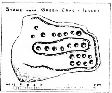
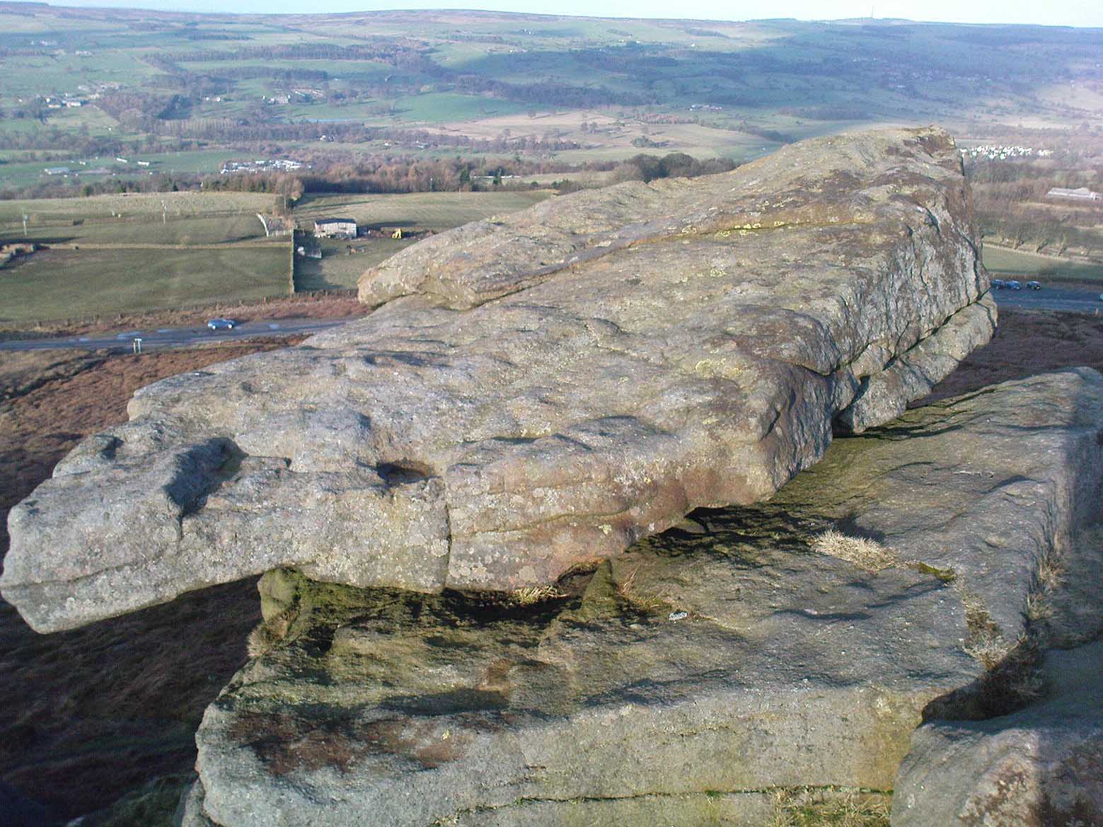
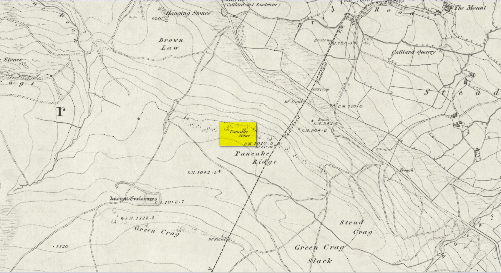
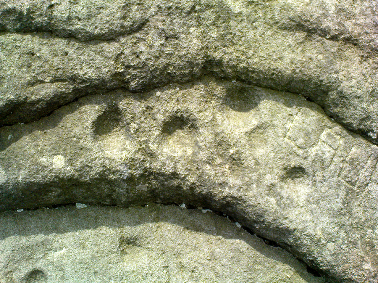
We were up here again the other week: wind, hail and snow blowing like hell, thankfully keeping the place to ourselves! To get here, head up Cow Pasture Road from the train station and up to the Cow & Calf Hotel near the famous rocks. Go past it a 100 yards or so and then look uphill onto the moors ahead of you. You’ll see a great over-hanging rock on the slope above you which looks as though its may fall down at any moment. That’s the Pancake Stone! Either walk up the steep path to get there quickly, or the longer route by taking the sloping diagonal path that runs eastwards until you’re on the same level.
Archaeology & History
Site shown on 1851 map
Highlighted on the first Ordnance Survey map of the region in 1851, this prehistoric carved stone had been known as the Pancake Stone by local people long before any antiquarians gave it their literary attention to the place. It would have had tales told of it, no doubt, but they were never written down. It’s an impressive, some would say precarious piece of rock: an elongated thin wedge of stone resting gently on the cliff edge, much like a rocking stone to be honest, seemingly hanging onto the edge of the geological ridge awaiting its fall down the slope; but that’s not gonna happen for many more centuries yet.
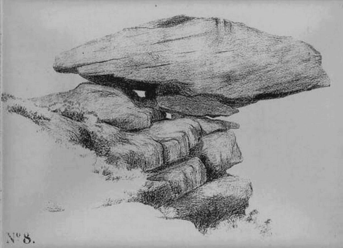
J. Thornton Dale’s 1879 drawingJ. Thornton Dale’s 1879 drawing
Much has been written about the petroglyph on the this wedge of stone, which covers much of its surface. Although a Mr J. Thornton Dale did a fine series of quite accurate drawings of this stone (and others on the moors) between 1878 and 1880, the first literary description of the Pancake rock carving appears to have been by the renowned J. Romilly Allen in 1882 (who evidently visited the stone on a cloudy or overcast day), saying that:
“On its upper surface are several cup-markings much obliterated by the actions of the weather, but some of them sufficiently distinct to prove their origin artificial, and to show that this rock was noticed in ancient times, and very possibly considered an object either of worship or superstition.”
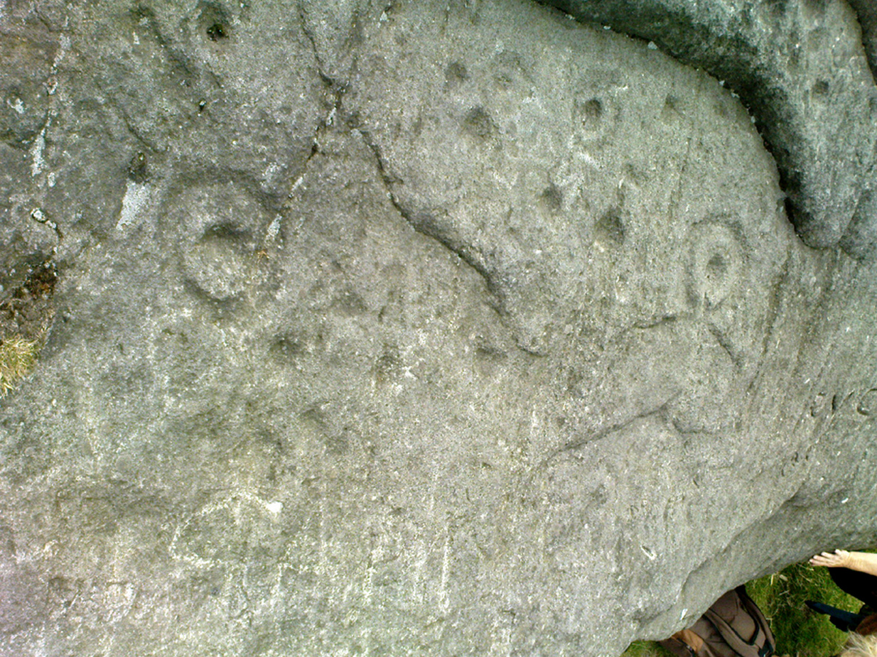
Close-up of CnRsLooking across the stone
This latter assumption is highly probable. Strong animistic notions (moreso than usual) would be very evident here. Its position on the land with its outward focus from here towards other notable points in the landscape (Almscliffe Crags is one obvious focus); as well as looking at the rock itself from other viewpoints, give the stone considerable ritual importance. Sections of the moorland plain behind it—known as Green Crag—was the Land of the Dead in ancient times, and it is more than likely that death rites would have been enacted here — though we may never know what form they took.
Dale’s 1879 sketch
The stone has what seems to be at least 54 cup-markings on its upper face, with numerous grooves meandering and connecting other points. In J. Thornton Dale’s 1879 drawing of the upper surface, you will note that a couple of the rings he included have all-but faded away and are not included in the more recent surveys. Of the primary design, rock art students Boughey & Vickerman (2003) described there being “six complete and five partial rings” amidst the morass, but much of the design is very worn and, originally, there was probably a bit more to it all. The rock upon which the main Pancake Stone rests also has some worn cup-marks etched on its surface, a couple of which can be made out in the top photo.
Folklore
Good old Nicholas Size (1934) added this site to his list as a place where he had visions of the old christian cult, upon whose bare face were enacted blood rites and sacrifice. One Beltane Eve when he decided to amble up onto the moor edge, he could see a strange glow coming from behind the rock. He continues:
“Then suddenly I noticed there was a figure dancing upon it. The figure seemed to swirl round and round with floating draperies, grey or white, and I can only say that it looked very uncanny. Stupidly, I wondered that anybody could be such a fool as to dance in the darkness upon that precarious footing…”
But such activities on these moors, at certain times of the year, have been enacted for many centuries. It’s just kept quiet and, as more modern pagans (as they like to call ’emselves) keep coming up here and to other places, so the original folk move to their older and increasingly more secluded spots… In the latter half of the 20th century the site was used as a focus by chaos magickians, shortly after the inception of that Current.
References:
Allen, J. Romilly, ‘The Prehistoric Rock Sculptures of Ilkley,’ in Journal of the British Archaeological Association, volume 35, 1879.
Allen, J. Romilly, ‘Notice of Sculptured Rocks near Ilkley, with some Remarks on Rocking Stones,’ in Journal of the British Archaeological Association, volume 38, 1882.
Boughey, Keith & Vickerman, E.A., Prehistoric Rock Art of the West Riding, West Yorkshire Archaeology Service 2003.
Cowling, Eric T., Rombald’s Way, William Walker: Otley 1946.
Hedges, John, The Carved Rocks on Rombalds Moor, WYMCC: Wakefield 1986.
Jennings, Hargrave, Archaic Rock Inscriptions, A. Reader: London 1891.
Size, Nicholas, The Haunted Moor, William Walker: Otley 1934.
Speight, Harry, Upper Wharfedale, Elliott Stock: London 1900.
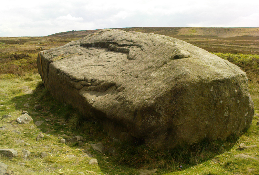
Dead easy to find this one! Get to the Cow & Calf Hotel and walk up the slope onto the moor ahead of you. If you want a direction-pointer, head for the large, seemingly overhanging rocks which are the Pancake Stone, at the top of the ridge, but a few hundred yards to the right (west). Once you reach the level on the moor proper, you’ll see this large haystack-shaped boulder close by. That’s it!
Archaeology & History
This tends to be one of the spots I stop at when doing my tourist walks, to i) let folk get their breath back after ambling from the car park, via Hanging Stones and Map Stone; ii) to drink in the view, and, iii) to begin acquainting themselves with the landscape as it was when this stone was carved (over many decades, perhaps longer), and the animistic cosmology underlying people’s notions of their land. It can be quite an education…
Haystack Rock crushes local manFertility symbol, or Rorschach response?
The Haystack Rock was a very important boulder in the mythic landscape on this plain. It stands near the western end of the Green Crag Necropolis: a huge area of land on these moors where, quite simply, the people of these hills laid their dead. Effectively, the Haystack Rock stands on the edge of Ilkley Moor’s “Land of the Dead”.*
Highlighting this quite firmly, we find that prehistoric walling ‘separates’ this great boulder from the other part of the Plain close to its east and southern sides (walling on its western side is as yet unproven). It was a boulder that was specifically sectioned-off, away from any tombs. All along this Plain are numerous small cairns, many with rock-art nearby, and certain parts of the Plain are split into sections by ancient walling (though a precise map of the walling, tombs and rock-art on this moorland ridge has yet to be done).
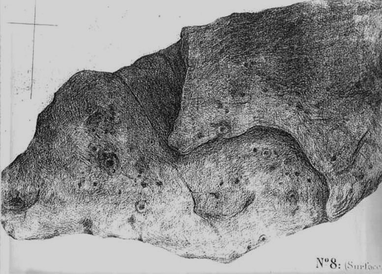
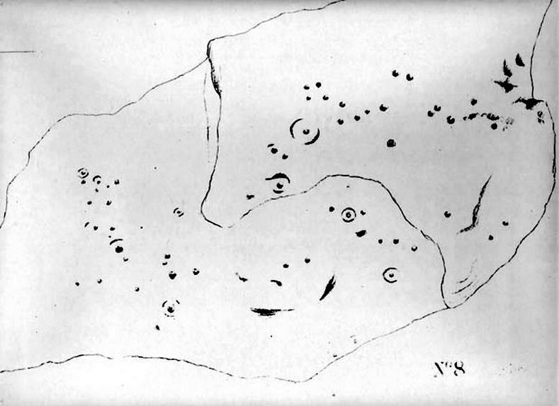
J.Romilly Allen’s 1879 images
As far as the textbooks are concerned, we find the first mention of this great carved boulder came from J. Romilly Allen at the end of the 1870s. By 1900, a number of people had been here and written of its grandeur; but, as with cup-and-rings in general, its non-linear form and design elicited the usual notions of bewilderment, druids and puzzled ideas. Much like today really!
Drawing of the central design (Hedges, 1986)
But this is a big and decent carving, with about 60 single cup-markings, 10 cup-and-rings, and various twizzly grooves and lines linking cups to others, and others going to seemingly nowhere. Some of these lines, of course, may be weathering, or weathered channels emerging from once shorter lines. We might never really know for sure what the original carving actually looked like. On the north-facing side is what looks like a decidedly human figurine etched onto this great boulder, in good old cup-and-ring style. I’ve shown this to a few hundred people and they all seem to make the same remark: it’s a woman with her legs wide open — an early form of sheela-na-gig on Ilkley Moor no less! But whether this was intentional (many folk think so), or just us seeing something we want to see (men in particular!), we might never know.
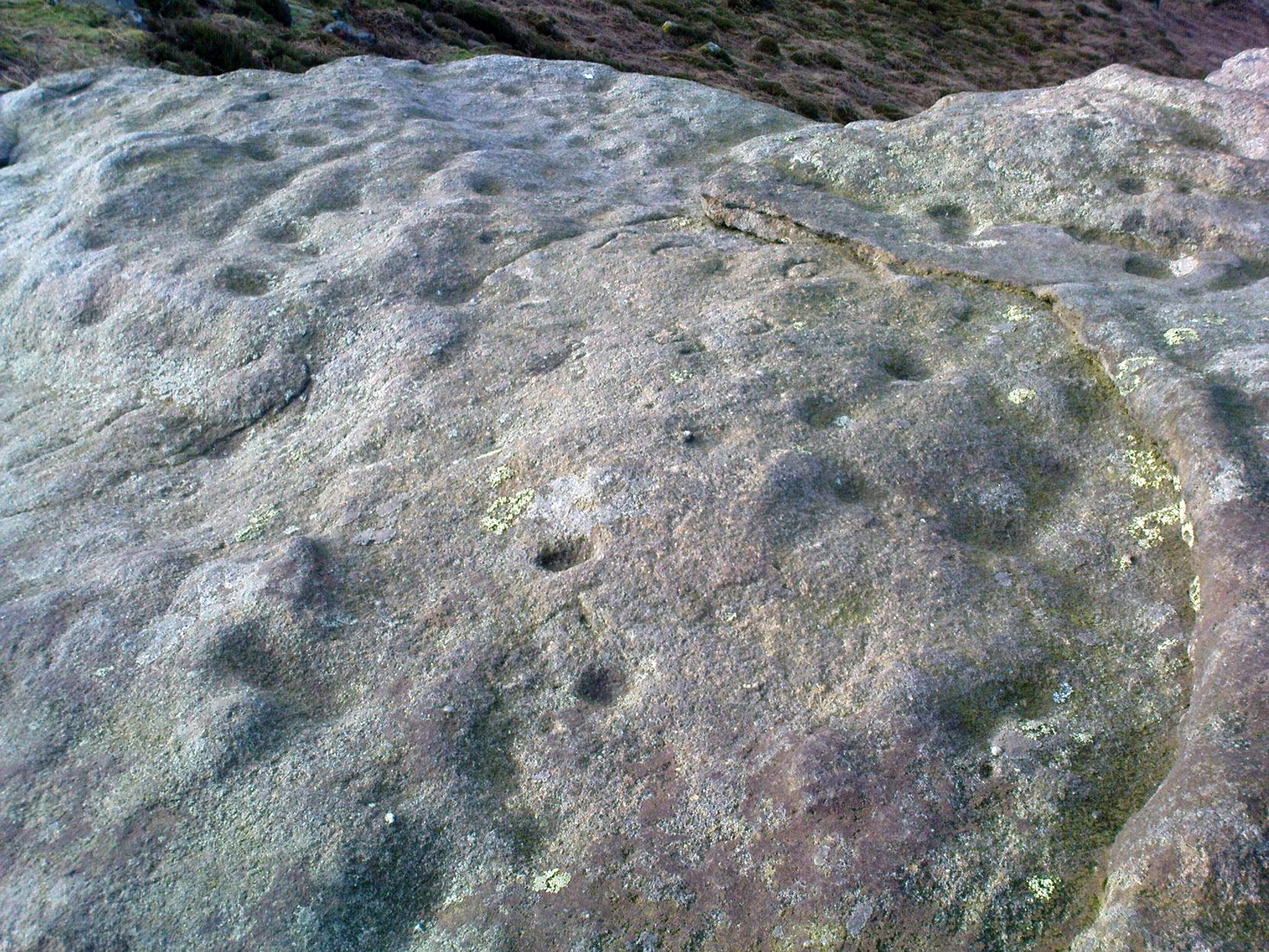
Ancient cup-marks with vandal marksMore cup-and-rings with vandal marks
The black-and-white illustration above that shows what seems to be just about all elements of the carving in considerable detail, may well be accurate, but it’s nothing compared to seeing the carving first-hand. When it comes to ancient rock-art, detailed drawings are one thing, but the real thing is altogether much much better! Check it out and see for yourself…
Folklore
I’m not too sure what credibility we should give to Nicholas Size’s (1934) extravagant claims, but this was one of the sites he alleged to have seen visions of druidic rites and ghostly figures!
References:
Allen, J. Romilly, ‘The Prehistoric Rock Sculptures of Ilkley,’ in Journal of the British Archaeological Association, 35, 1879.
Bennett, Paul, The Old Stones of Elmet, Capall Bann: Chieveley 2001.
Boughey, Keith & Vickerman, E.A., Prehistoric Rock art of the West Riding, WYAS: Wakefield 2003.
Hedges, John, The Carved Rocks on Rombalds Moor, WYMCC: Wakefield 1986.
Size, Nicholas, The Haunted Moor, William Walker: Otley 1934.
* It’s gotta be pointed out that Ilkley Moor’s ‘Land of the Dead’ extends much further than just the Green Crag. Much of the extended land above here to the south was an important area, where at some places rites of the dead were performed. The supposed ‘settlement’ nearby (as well as the lesser known one on the moor west of here, on the moor above Ilkley Crags, near Cranshaw Thorn Hill) was likely to be a place where the dead were rested for a period. But more about that in the section on the Green Crag Settlement…
Go to the Cliffe Castle Museum on the outskirts of Keighley town centre (dead easy to find with car park to rear) and explore the museum! You’ll find it eventually!
Archaeology & History
Comet Stone, Cliffe Castle Museum, Keighley
This lovely-looking carving has been on a bit of walkabout over the last hundred years or so! We’re not quite sure exactly where it first lived, but old records tell that it was found upon the Grubstones Ridge, which is a small section of the moor around and/or between the Great Skirtful of Stones giant cairn and the curious Roms Law, or Grubstones Circle, both on the very tops of Burley Moor (most folk call think of it as just another section of Ilkley Moor). Here it lived (approx grid reference SE 138 446) for several thousand years until, many centuries later, in the mid-19th century, one of them there christian chaps came along – y’ know the sorts. He was the reverend J.A. Busfield and came to live upon the heathen edge of our Rombald’s Moor at a great house called Upwood. Like many of these weird people, he took a bit of a shine to our ancient relics and, amidst one of his sojourns to the Grubstones one day, came upon this multiple-ringed stone lying amidst the heather, close to the old circle of Roms Law. Liking it so much, he thought he’d have it as an ornament in the grounds of his hall at Upwood, on the southern edges of the moor overlooking Riddlesden and Keighley — and there it stayed, living quite comfortably, until 1925.
It then spent nearly fifty years living enclosed in the huge abode of Keighley Museum until, in 1971, it was presented by a certain Mr. R.W. Robinson of the same establishment, to Keighley Council, who thought in their weird ways to lean “it against a pile of rocks on the pavement of Bow Street, near Keighley Bus Station, with a small plaque,” telling of its tale and of other cup-and-rings nearby. And there it stayed until more recent years, when it was returned back to the Cliffe Castle Museum – safe, quiet and looked after each night!
Drawing of the carvingCowling’s early drawing
It’s a lovely, almost archetypal carving: a simple cup surrounded by four complete rings, with a ‘tail’ coming off the edge, similar to the image of a comet flying through the skies – which is, perhaps, what this carving represented. Of course, it could have been something completely different!
The region where this stone was located was an important area for the dead in ancient times – a motif that’s common to many cup-and-rings – and it seems probable that the stone itself was once part of a tomb, though we seem to have no record substantiating this. The carving was highlighted by William Cudworth as being in Upwood on a map dated 1847-51. The next description of it was by Arthur Raistrick in 1936. John Hedges (1986) listed it as stone-216 in his survey; then Boughey & Vickerman (2003) re-list it as stone 351.
NOTE – Don’t confuse this carving with another that is held in the same museum here, the Cliffe Castle or Baildon Moor 144 carving. Well worth having a look at!
References:
Boughey, Keith & Vickerman, E.A., Prehistoric Rock Art of the West Riding, WYAS: Leeds 2003.
Cowling, Eric T., Rombald’s Way, Otley 1946.
Hedges, John, The Carved Rocks on Rombald’s Moor, WYMCC: Wakefield 1986.
Raistrick, Arthur, ‘Cup-and-Ring Marked Rocks of West Yorkshire,’ in YAJ, 1936.
Not too hard to find really. On the far western edge of the King’s Park golf course, head for the highest point where the small cliffs drop down. From here, walk down the footpath on the slight slope south, just below where the small copse of trees are, and you’ll see the singular small flat stone in the grasses near the footpath you’re walking along. If you can’t find it – look around!
Archaeology & History
A little-known but fascinating isolated carving, first described by David Morris at the sixth meeting of the Stirling Natural History and Archaeological Society in 1901. It is found on the western edge of the town, above the rocky edges not far from the pond of St. Thomas’ Well on the far edge of the golf course. Morris’ finding was written up in their fine journal, where he wrote:
“In the King’s Park, about 50 yards east of the cliff where a seat overlooks the Douglas Terrace sand quarry, there is a smooth surface of rock showing through the turf, measuring two-and-half feet by one-and-half feet… On it is a cup-shaped hollow, outside the rim of which is a well-marked hollowed ring, beyond which is another faintly marked, concentric circular groove. The cup-mark measures one-and-a-half inches across; the inner rim of the first circle is 4 inches, and the outer rim is 6 inches in diameter. The outer circle, if complete, would be 9 inches in diameter. The depth of the central hollow is half-an-inch, and of the inner groove fully one-quarter of an inch. The markings are plainly artificial…”
King’s Park CR – central design, pointing to northernmost cup
In good sunlight, it is obvious that the carving is a fine example of a double-ringed cup-and-ring carving – though the outer ring may not be complete. The Scottish Royal Commission lads told that “this rock outcrop bears three cup marks” – one of which has the rings surrounding it. In the first photo here, the southernmost cup-marking is highlighted in the centre of the two shells which were on the rock when we arrived.
However, there’s definitely more to this carving than previous investigations have outlined. It seems that the northernmost cup-mark has a ring and a possible outer-ring. There is also a distinctive linear carving, which at first seems like a primitive triangle, just below the southernmost cup – as we’ve tried illustrating here in the photo which Mikki Potts took. It’s faint, but once you see it, it’s obvious that it’s there. Other faint lines of similar nature also seem apparent near the northernmost cup-marking, but we will have to wait for rubbings and further visits in better light to ascertain the full image on this rock. Well worth checking out if you like your rock art! (can any of you Scottish rock-art fanatics have a closer look at this? – take a rubbing of it and see what other aspects are on this design)
Faint linear carvings on southern end of the rock
One other thing which seemed apparent when we were here: this site has all the geomantic hallmarks of accompanying a burial at some time in the ancient past. Its isolation here is unusual and the carving is only 50 yards from the highest point hereabouts, where you have 360-degree views all round, typifying the position of many prehistoric tombs.* Does anyone know about such features, or have records of any field-name surveys taken, which might confirm or deny this thought? Twouldst be good to know!
References:
Feachem, Richard, Prehistoric Scotland, Batsford: London 1963.
Morris, David B., “Cup and Ring Marked Rock Surface in King’s Park,” in Stirling Natural History & Archaeology Society Transactions, 1900-1901.
Morris, Ronald W.B., The Prehistoric Rock Art of Southern Scotland, BAR 86, Oxford 1981.
Royal Commission on the Ancient and Historical Monuments of Scotland, Stirlingshire – 2 volumes, HMSO: Edinburgh 1963.
Royal Commission on the Ancient & Historical Monuments of Scotland, Archaeological Sites and Monuments of Stirling District, Central Region, Society of Antiquaries of Scotland 1979.
* Since writing the above, thanks the correspondence of Paddybhoy, we’ve learned that there definitely were prehistoric tombs close by; one being just at the bottom of the ridge below the carving, on Douglas Terrace. Records describe several other prehistoric tombs nearby at Birkhill House, the Birkhill Sandpit and Coneypark Nursery. However, I still think it most probable that there were other tombs and more rock art, probably along the edges of King Park, aswell as the Cambusbarron plain. These need locating.
Cup-and-Ring Stone (lost): OS Grid Reference – SE 142 396
Archaeology & History
Listed in Boughey & Vickerman’s (2003) survey as ‘stone 186,’ I first came across a reference to this carving when I was young, in a short article by Sidney Jackson (1964) in his Cartwright Hall archaeology journal. A letter was sent to Mr Jackson in 1963 by a Mr Bernard Stubbs of Baildon, who wrote:
“This morning I visited Hope Farm, Baildon, where Mr Jim Bell, the farmer, told me of a cup-and-ring boulder which he had discovered while digging a hole to bury a sheep, in the polt of land at the rear of the farmhouse… He stated that the hole was covered with cup-and-ring markings. Unfortunately, the hole has been filled and concreted over.”
And no one has seen it since then! Damn! Recently we discovered a cup-marked stone carved on a now-upright stone in old walling in one of the fields immediately west of the farm, but it’s obviously a different one from that described in Mr Stubbs’ letter. There are several other carvings in this region that are not in the official records, but this particular ‘lost’ stone remains lost for the time being!
References:
Boughey, Keith & Vickerman, E.A., Prehistoric Rock Art of the West Riding, WYAS: Wakefield 2003.
Jackson, Sidney, ‘New Cup-and-Ring Boulder,’ in Cartwright Hall Archaeology Group Bulletin, 9:1, 1964.
Cup-and-Ring Stone (destroyed?): OS Grid Reference – SE 129 379
Archaeology & History
Over the years, many of us have looked for this site but without any success. If it hasn’t actually been destroyed, it could be in someone’s garden wall, probably without them even knowing about it. Indeed, even the grid reference given here is only an approximation (mine differs from the one cited by Boughey & Vickerman, who put the carving closer to SE 126 381) and the stone could have been a few hundred yards either side of here. The main description of it comes from a letter written by a Mr T.P. Noble in 1964, which was cited in Sidney Jackson’s article ‘Hirst Wood Cup-and-Ring Boulder,’ in Bradford’s Cartwright Hall archaeology journal, where Mr Noble wrote:
“Mr Cooper, who built these houses (Hirst Wood housing estate) about 1935, once told me that there was a perfect example of a cup-and-ring stone here, but later, when he came to search for it, he couldn’t find it. It appears it must have been removed and possibly broken-up when the foundations of the houses were excavated.”
Of course, as we don’t know the exact whereabouts of the carving, nor have we been left with an illustration of the stone, it’s difficult to say whether the description given by the great archaeologist Sir Mortimer Wheeler in 1958, is referring to the same carving. Wheeler told us that one day in his childhood when he was out walking with his father, R.M. Wheeler, they came across a seemingly unknown prehistoric carving, saying,
“On one memorable day in the woods beyond Saltaire, we found an unrecorded cup-marked stone (later, I believe, recorded by my father in a British Association Handbook)” – that work being the Handbook to Bradford and Neighbourhood (1900), edited by R.M. Wheeler.
Naathen…if there are any people from the Hirst Wood area reading this and who might know of an old carved rock stuck in some old garden walls nearby, let us know. You’ll be credited as the person who re-discovered this long lost carving – and we can get the story in the local newspaper.
References:
Boughey, Keith & Vickerman, E.A., Prehistoric Rock Art of the West Riding, WYAS: Wakefield 2003.
Jackson, Sidney, ‘Hirst Wood Cup-and-Ring Boulder,’ in the Cartwright Hall Archaeology Group Bulletin, 9:2, February 1964.
The best and easist way to get here is to drive west past Dick Hudson’s pub along the moor road for about a mile till you reach the left turn of Heights Lane. Stop here! (if you’re now going downhill to East Morton, you’ve gone past it) On the opposite side of the road is a gate and a footpath onto the moor at the spot called Fenny Shaw Low Well (small copse of woods adjacent to your right). Walk a quarter-mile up the path, bearing left where the path diverges (ignoring the ‘Private’ sign) and head for the derelict building. Less than 100 yards before it, notice the large boulder to your right, on the slope – that’s it!
Archaeology & History
Old inaccurate drawing, c.1982
I first came across this on one of my countless ambles on these moors as a teenager. It was a cold, windy day as I recall – hence the reason for my sketch of the stone being a bit vague! The bit of paper on which I drew it, was included in one of my unpublished hand-written booklets. A few years later an image of the carving appeared in Mr Hedge’s (1986) fine collection, in much better detail than my scratty little pic!
Some cup-marks highlighted
It’s a ‘big rock’ and stands out on the slope here. There’s at least one complete cup-and-ring which is visible on the northern edge of the rock and there are between 17 and 30 other cups scattered across its surface, which has been greatly eroded by our timely forces of wind, rain, ice and snow.
Hedges’ 1986 sketch
In ambling around looking at the other stones in the vicinity, along with finding the small Littlestone cup-marked rock further up the slope, we also found, just below the faded old Big Stone, another quite large rock upon which, quite recently, someone has decided to etch four complete cup-and-ring symbols. These appear to have been done either to,
i) assess degrees and speed of erosion on rock carvings;
or,
ii) pure artistry.
Whichever it may be (and there’s been various cries of “vandalism” when such carvings have been etched by some folk on otherwise virgin rock over the years), let it be known that the Big Stone’s partner was etched c.2008-9. Does anyone out there know who did this ‘new’ carving?
References:
Boughey, K.J.S. & Vickerman, E.A., Prehistoric Rock Art of the West Riding, WYAS: Leeds 2003.
Hedges, John (ed.), The Carved Rocks of Rombald’s Moor, WYMCC: Wakefield 1986.
Various ways to get here, but I suppose the easist is by walking along the path just above the woods from the main A61 road, where there’s the junction turn-off to Wike. You have to walk perhaps 1000 yards until eventually, a couple of hundred yards up the slope to your left (south) you’ll see the boulder stuck in the field. You’re there!
Archaeology & History
The Grey Stone, Harewood
Described first by Cowling & Hartley in 1960, this multiple-ringed carving gives the distinct impression that it aint quite as old as our more traditional cup-and-rings on the moors west and north of here – but I s’ppose we’ll never know for sure. There isn’t a central cup to this concentric-ringed carving, which is quite unusual, and which is why I get the impression that it’s from a later archaeological period. However, saying that, there are several other faint cup-markings on the southwest and east-faces of the boulder (which I forgot to photograph when I was there – idiot that I am!). Boughey and Vickerman (2003) illustrate as many as 18 other cup-marks on the rock surface – which they list as stone 399 in their survey.
Although there seems to be no folklore attached to this isolated carving, rock-art authority Graeme Chappell noted how “the midwinter full moon set behind Almscliffe Crags at its extreme northerly setting point in Bronze Age times” from this Grey Stone.
The archaeologist S.A. Moorhouse (1981) also pointed out how some of the many Grey Stones (which usually means ‘a boundary stone’, sometimes very ancient ones) found in northern England, derive their name from the old word har, which “can also mean ‘grey, hoar,’ used to describe natural boulders, possibly with cup-and-ring markings” – just as we have here!
References:
Bennett, Paul, The Old Stones of Elmet, Capall Bann: Milverton 2001.
Boughey, Keith & Vickerman, E.A., Prehistoric Rock Art of the West Riding, WYAS: Wakefield 2003.
Cowling, E.T. & Hartley, C.E., ‘A Ring-Marked Rock: The Grey Stone,’ in YAJ 1960.
Moorhouse, S.A., ‘Boundaries,’ in Faull & Moorhouse’s West Yorkshire: An Archaeological Survey, volume 2, 1981.


 Allen 1879")


")


