A little-known multiple ringed carving was discovered a few years ago during the excavation of a prehistoric cairn just immediately east of the A701 roadside, several miles south of Broughton. The cairn itself had been recognised many years prior to the recent excavation, when one of two cists inside it was noted by R.B.K. Stevenson (1940), and which was subsequently described in slightly more detail in the Royal Commission Inventory (1967). But when the modern investigation was undertaken by the Biggar Archaeology Group in 2008, a damaged but impressive carving was uncovered that somehow hadn’t been noticed before. It was described in Tam Ward’s (2008) excavation report where he told that,
Carving in situ (photo courtesy Jim Ness)Carving looking N: courtesy Jim Ness
“lying almost immediately on the east side of Cist 1 is an angular rock…measuring 1m long and over 0.3m wide on the uppermost face, itself lying at an angle facing SW and away from the cist. The rock has fractured due to weathering in post deposition times, as indeed several other surface stones had, but on the widest part of the upper surface are at least seven concentric lines faintly pecked into the smooth flat surface of the stone. The lines are up to 10mm wide and appear to have been intended to form semi ovals on the edge of the rock. The outer ring forms an arc of c270mm on the long axis by c140mm on the short one (the former measurement being straight between the ends of the lines and the latter being a radius across the design). The terminals of the inner curved line are about 80mm apart. The lines are slightly irregular in distance from one another. Although it is far from certain, it does not appear that the rock has been part of a larger one with a more complete design on it, rather the pecking appears not to have been finished since the surface of the rock is similar in appearance overall while the abrasion of the carving varies.”
Fractured design (photo courtesy Jim Ness)
The carving remains in place with the cist, which was covered back over when the excavation had been finished.
Carvings such as this are uncommon in this neck o’ the woods; although less than a mile downstream from here, on the other side of the river, another petroglyph—known as the Drumelzier carving—accompanied another prehistoric tomb. Apart from this, there’s a great scarcity of carvings scattering the Lowlands—although it’s likely that there are others hiding away, waiting to be found on these hills…
References:
Royal Commission on the Ancient & Historical Monuments, Scotland, Peeblesshire – volume 1, Aberdeen University Press 1967.
Stevenson, R.B.K., “Cists near Tweedsmuir,” in Proceedings Society Antiquaries, Scotland, volume 74, 1940.
Tumulus (destroyed): OS Grid Reference – SX 0309 5227
Archaeology & History
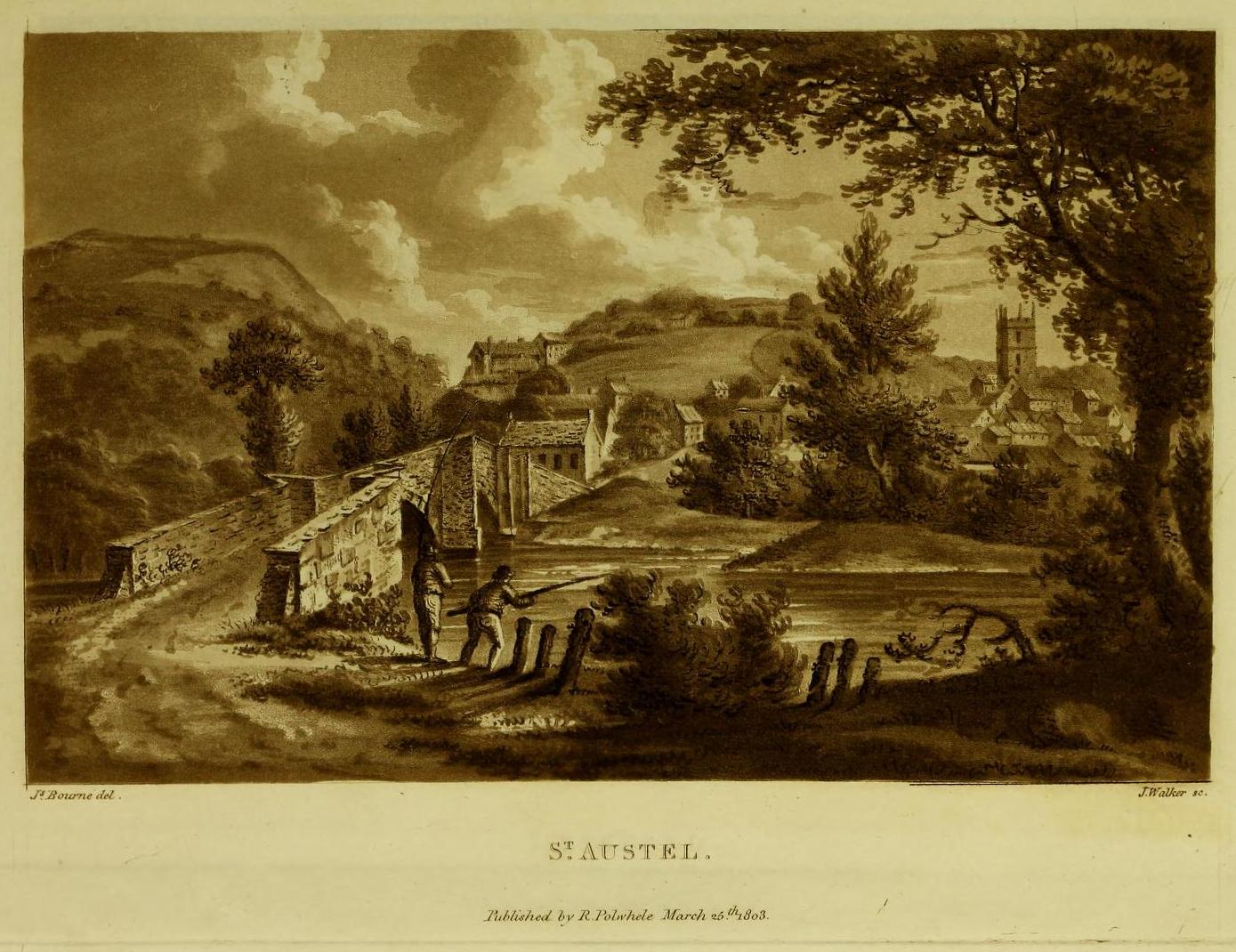
More than two hundred years ago, an impressive prehistoric burial mound lived in an area that used to be known as Gwallon Down, not far from the impressive Long Stone monolith, about half-a-mile west of Charlestown on the southern edges of St. Austell, but it was completely destroyed in 1801. Thankfully there was a lengthy account made of the site in John Whitaker’s (1804) huge work, but there seems to be little else known of it. He told us:
“In the middle of that extended waste, the downs of St. Austle, was, what was called One Barrow. This waste, in 1801, was resolved to be enclosed, and the barrow was obliged to be levelled. In this operation, the single workman came near the centre, and there found a variety of stones, all slates, ranged erect in an enclosure nearly square. The stones were about one foot-and-a-half in height, apparently fixed in the ground before the formation of the barrow. The stones were all undressed, but had little stones carefully placed in the crevices at the joints of the large, in order to preclude all communication between the rubbish without and the contents within. On the even heads of these stones was laid a square freestone, which had evidently been hewn into this form, which seemed to rest with its extremities on the edges of the others, and was about eighteen or twenty inches in diameter. The summit of the barrow rose about eight or ten feet above all. In the enclosure, the leveller found a dust, remarkably fine, and seemingly inclining to clay. On the surface it was brown, about the middle downwards it took a dark chestnut colour, and at the bottom it approached towards a black. On stirring it up, a multitude of bones appeared, different in the sizes, but none exceeding six or seven inches in length. Among them were some pieces about the largeness of a half-crown, which, from their concave form, convinced him they were parts of a skull. The whole mass of bones and ashes might (he thought) be about one gallon in quantity. On touching the bones, they instantly crumbled into dust, and took the same colour with the same fineness as the dust in which they were found. They were exceedingly white when they were first discovered, but remarkably brittle; the effect assuredly of their calcination in a fire, antecedent to their burial. Much in fineness and in colour with these ashes, appeared several veins of irregular earth on the outside of the enclosure; which, from their position without, yet adjoining, and from the space occupied by them there, he conjectured to have been bodies laid promiscuously upon the funeral pile, but which I conjecture to have been only the ashes adhering to the ground, and not possible to be separated from it, for a burial with the rest within the enclosure. They had nothing of sand in them, but seemed inclining to clay, and even more so (from the adhering soil probably) than the dust of the enclosure. And, as the workman was fully convinced of what every one else must acknowledge, that the ashes and the bones of the enclosure had once belonged to a human body, he very properly took up the whole with care, placed the stones nearly in their original posture within an hedge contiguous, then in building, placed also the bones with the ashes within their original enclosure there, and even placed the covering-stone over both.”
One wonders where precisely the hedgerow happened to be where the stones were placed “nearly in their original posture”, and if this reconstruction was ever recovered.
The site was subsequently mentioned in Polwhele’s (1816) massive survey, reiterating Whitaker’s description, simply telling how:
“With respect to the monumental remains in the neighbourhood of St Austel, a very ingenious correspondent says in one of the mounds of earth on our downs which was lately levelled a kind of urn was discovered which evidently contained human ashes many of the bones were entire but appear to have been calcined I am well acquainted with the man who dug this up.”
References:
Borlase, William Copeland, Nænia Cornubiæ, Longmans Green Reader: Truro 1872.
Hammond, Joseph, A Cornish Parish: Being an Account of St. Austell, Skeffington & Sons: London 1897.
Polwhele, Richard, The History of Cornwall – volume 2, Law & Whittaker: Truro 1816.
Whitaker, John, The Ancient Cathedral of Cornwall – volume 2, John Stockdale: London 1804.
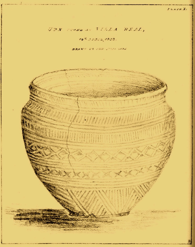
All remains of this prehistoric burial site have obviously long since fallen into only the vaguest of memory, but its incidence deserves reviving for those who may live nearby and seek for a place where our truly ancient ancestors once faired. Here, beneath the modern buildings of homo-profanus, less than a mile north-east of Newcastle city centre, a small prehistoric burial chamber, or cist, was uncovered quite accidentally by a Mr Russell Blackbird (1832) in the first-half of the 19th century. In a letter to the newly-formed (as it was back then) Society of Antiquaries of Newcastle in April of that year he told,
“In trenching some ground for planting, this morning, we discovered a stone vault, 4 feet long by 2 feet wide, and 20 inches deep, deposited in a dry hard marl below the soil, which we were taking out for making the walks in the garden. It contained the bones of a man, the head, in particular, quite perfect, with all the teeth in it. Also a small urn (was found)… There was some red-coloured earth in the urn which the labourers threw out.”
Mr Blackbird sent the antiquarian society a sketch of the urn that he and his colleagues discovered, reproduced here.
References:
Blackbird, Russell, “Account of the Discovery of a Stone Vault and Urn, at Villa Real, Jesmond,” in Archaeologia Aeliana, volume 2, 1832.
Acknowledgements:Huge thanks for use of the Ordnance Survey map in this site profile, reproduced with the kind permission of the National Library of Scotland.
Halfway between the standing stone of Tangy Glen and the cup-marked stone of Allt a’ Ghoirtein, is a rounded hill that has for a long time been turned to farming. On top of here in the 1950s, the President of the Kintyre Antiquarian Society, a Mr Duncan Colville, came across the remains of an ancient burial cist, roughly 200 yards north of Killarow Farm. A short account of the find was written by Mr & Mrs Scott (1957) based on Colville’s description. They wrote:
“The cist, 3ft 8in long by 1 ft 11in wide at maximum, and about 2ft deep, had a stone-lined bottom and was covered by a slab originally 5ft 6in by 3ft in size, but now split into two. The cover slab lay not far below the surface, and there was no sign of a cairn. The cist had obviously been rifled, for a layer of clay at the bottom contained fragments of coal and modern glass; on the other hand, a few pieces of cremated bone may have been part of the original burial.”
When the Royal Commission (1971) dudes visited the site a few years later, they could find no remains of it. The cist is believed to have been covered over and remains hidden underground.
References:
Royal Commission Ancient & Historical Monuments of Scotland, Argyll – volume 1: Kintyre, HMSO: Edinburgh 1971.
Cup-Marked Stone (removed): OS Grid Reference – NT 128 709
Archaeology & History
“M” marks the cupmark
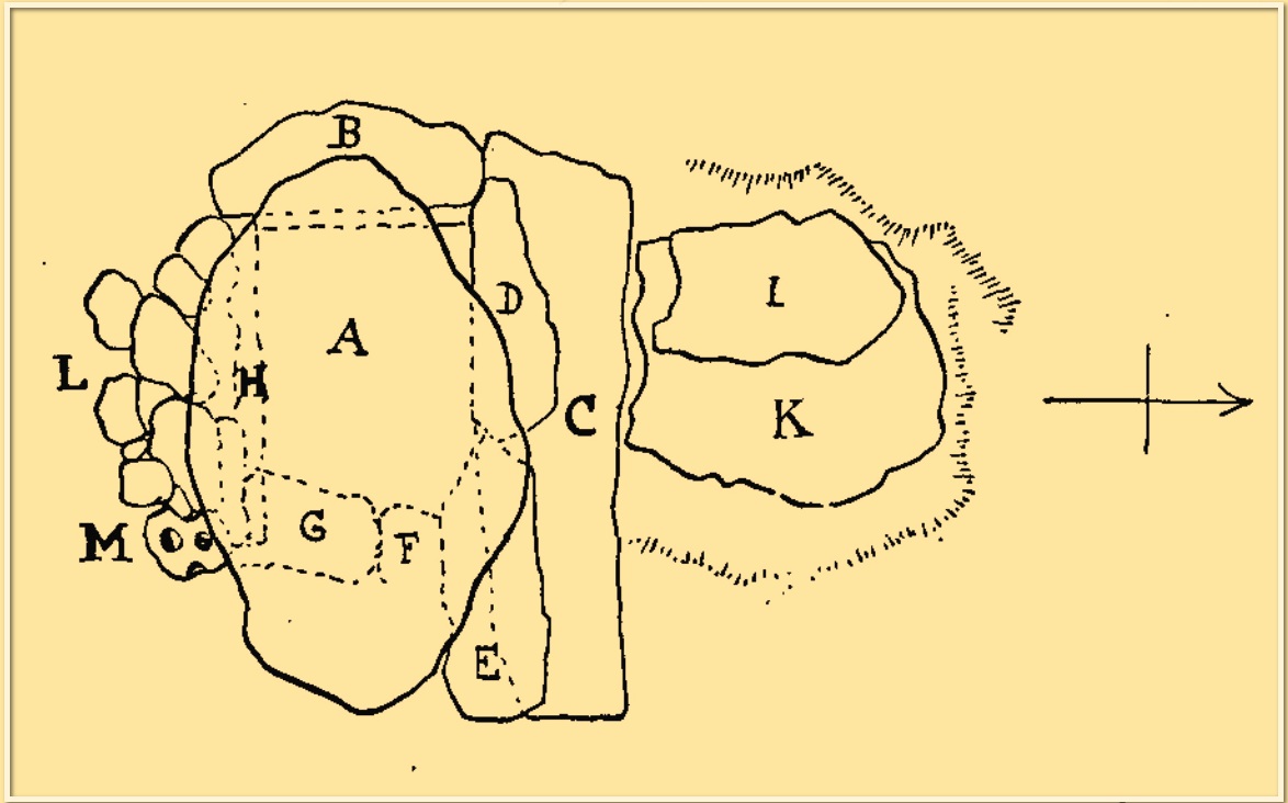
A simple cup-marked stone was located inside a prehistoric burial cist that was discovered by quarry workmen in November 1897. The cist was subsequently excavated by Fred Coles (1898) who found therein (amongst other things) a simple cup-marked stone whose present locale is a box somewhere in Edinburgh’s National Museum (could someone send us a photo please?). The carving comprises simply of two complete cups and portion of a third, all close to each other on a small stone that was located on the south-side of the cist (see ‘M’ in the attached diagram). Coles described the carving thus:
“During the removal of (some) small stones, one, when the damp soil was rubbed of, showed two cup-marks, about 1½ inch wide each and ½ inch apart. The stone itself measures 5 inches by 4¾, and appears to be but a fragment of a larger one, one edge showing part of a third cup. The cups all show the tool-marks usually noticed on these mysterious sculpturings.”
Tumuli (destroyed): OS Grid Reference – NU 273 046
Archaeology & History
In a lengthy letter describing the cist burial at Cliff House, its author, Mr W. Dunn (1857) told that there were additional prehistoric remains nearby, that had only recently been destroyed. He told:
“It appears that, a few years ago, in the immediate proximity of the present discovery (at Cliff House, Ed.) two or more tumuli were found which contained urns and bones; and flint arrow heads of elaborate finish have been occasionally met with.”
I can find no additional information about these sites.
In the same article, a Mr Kell told that during the construction of the Amble piers a half-mile to the west, “some years ago, he was sojourning in the neighbourhood, and …human remains were found on the removal of sand by the waves in a violent gale from the East.” What else is known of this place?
References:
Dunn, W., “Ancient Sepulchral Remains,” in Proceedings Society of Antiquaries Newcastle-upon-Tyne, volume 1, no.34, 1857.
Cist (destroyed): OS Grid Reference – NU 2730 0486
Archaeology & History
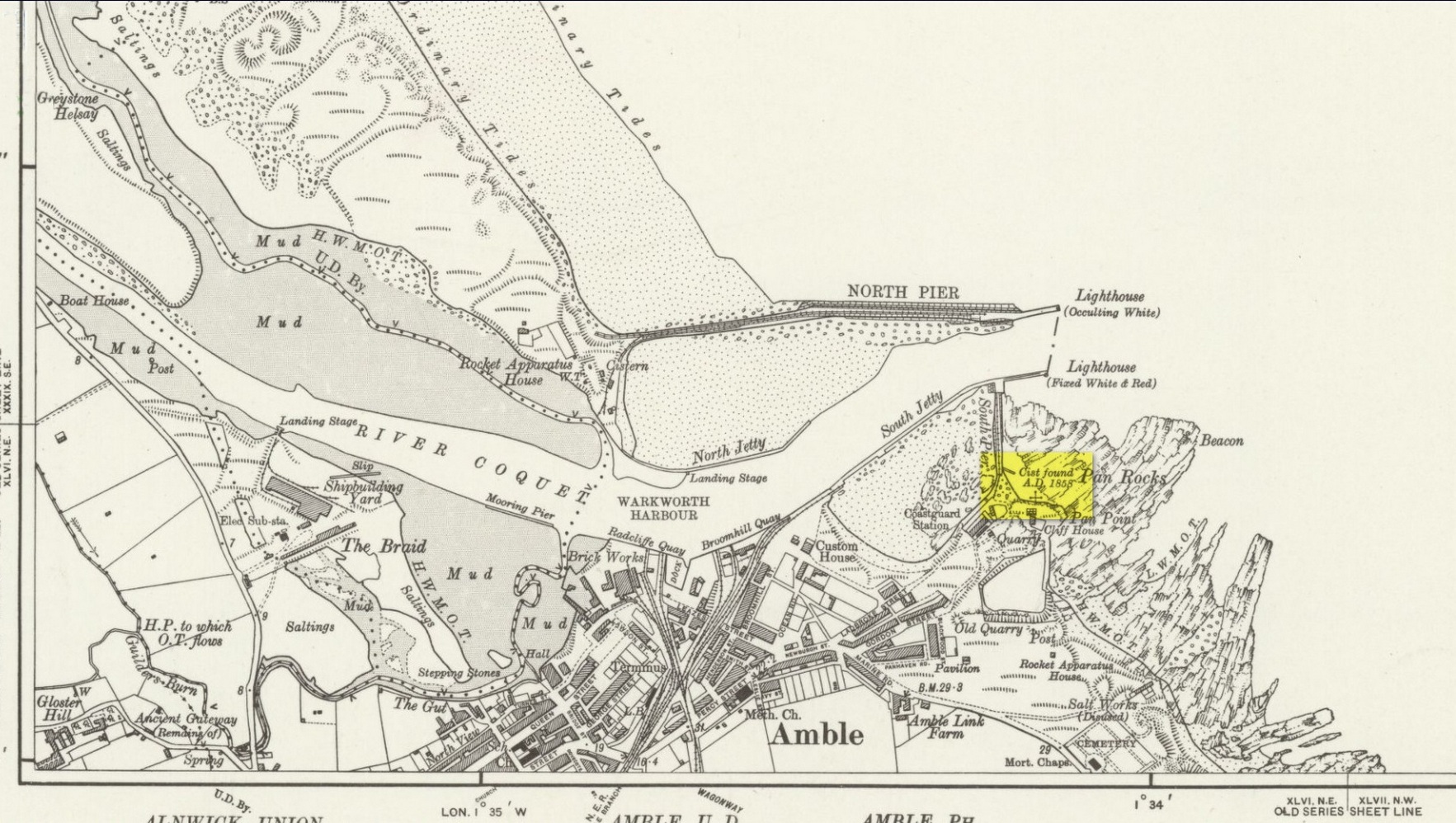
Site location on 1926 map
In November 1857, Collingwood Bruce read out a paper that had been sent to him by the Rector of Warkworth village (Rev. W. Dunn), describing “ancient sepulchral remains” that had been found near the cliff-edge above Pan Rocks near Amble’s lighthouse. It was a lengthy account which, in passing, also mentioned several other prehistoric sites close by that have long since been destroyed and which we have very little information about. Mr Dunn’s (1857) letter told:
“In the middle of April last, about 50 yards NE of the Cliff House, Amble, and about 20 yards from the end of what is called Warkworth South Pier, the pilots came upon a long upright stone, standing out of the shale to the height of twelve or fourteen inches,which had been laid bare by the recent heavy gales, but which, from its rude appearance, did not afford the idea of anything beyond a mere accidental tilting. Alongside this upright stone was a large unwrought slab, which, on being raised, was found to be the covering of a cist or sepulchral chamber containing a perfect skeleton. The figure was lying on its left side, with the head to the south-west, having the knees much doubled and with the right arm thrown back. By its side stood an urn of unbaked clay. This urn, now in the Museum of the Duke of Northumberland, resembles in size and shape that which was found a few years since at Hawkhill, and which is preserved in the Museum of the Antiquarian Society of Newcastle. It contained a small quantity of dark earth.
“Having given this general outline of the discovery, I shall proceed to offer such observations as I have been able to make,and have considered worth recording. I grieve to say that before the period of my visit the spoiler had been busy with these venerable remains. The skull had been broken up, the jaws smashed, every tooth appropriated, and the bones indiscriminately mingled, after many a century of undisturbed repose.
“The cist or chamber containing the remains was composed of four slabs inserted edge-wise in a cavity which appeared to have been dug out of the friable shale which lies upon the harder rock in this locality. It ranged south-east and north-west, and measured as follows: depth, 18½ inches; width, 26 inches; length at bottom, 4 feet; at top, 3 ft 4 in.; the difference between top and bottom measurements being accounted for by the shrinking of the ends. The cavity in the shale was much larger than the cist, and the space between the slabs and the shale was closely filled-in with stones, roughly broken, commingled with earth and larger stones. The side slabs projected somewhat beyond the ends. The bottom of the cist was covered to the depth of about half an inch, with dark, unctuous mould. Amongst the rubbish comprising the filling-up of the space above-mentioned, was found an angular piece of silex, probably an unfinished arrowhead; and in the south-west corner of the cist lay a large, smooth cobble stone, which, when considered in conjunction with the flint flake, the imagination may easily construe into the club of this ancient denizen of our shores. The slab which constituted the cover of the cist was of great size and extended in every direction considerably beyond it; and the upright stone was set up, not at one of the ends, but along its length. It is remarkable that a close inspection of these stones gave no trace of chisel-marks in any part. In order that the cover might lie level, pieces of shale, flags, etc., were laid on the uprights which formed the cist, wherever an irregularity presented itself.
“Within the memory of man, the rock ran out from this point for some yards into the sea at a considerable elevation; but the construction of a pier in the immediate neighbourhood has caused the removal of much of the stone, and the spray of our wild sea waves now dashes over the spot which for countless generations may have been peacefully tenanted by these nameless bones. At the same time, it does not appear probable that at any period there has been at this particular point a very deep covering of the sand and bent-grass which are found thick and rank upon the adjacent links.
“The skull must have been very characteristic, having attracted general observation from the extraordinary lowness of the frontal region, the great development of the occipital portion of the head, and the width and length of the lower jaw from its anterior junction to the articulation of the temporal bone. One person observed that during life the man “must have measured as much to the top of his eyebrows as to the top of his head.” The teeth are said to have been very beautiful and regular, and quite sound. With the exception of a front tooth, which was missing in the lower jaw, they were perfect. The thigh-bone measured 19½ inches, indicating a man of large size; whilst the porous internal organization of the bones gave probable evidence of comparative youth.
“The urn is unbaked, of a light clay colour, and measures in height 8 inches, in depth 7¼ inches, and in diameter 5½ inches. It is ornamented with zigzag scoring, alternating with dotted lines,and upright (and sometimes slanting) scorings, which appear to have been made with some rude instrument whilst the clay was moist. The scorings are continued over the edge of the rim. On being rather roughly seized by one of the men, it being expected that it contained treasure, a piece was broken off; but no material injury has been occasioned. The stone found in the cist does not resemble any that one may pick up on the neighbouring shore, and attracted attention from its bearing no assignable relation to what I may call the masonry of the tomb. I have since learnt that stones are not infrequently found in Teutonic graves on the Continent, and that recently a singular oval stone was found in a tumulus on Petersfield Heath.”
All trace of this site has disappeared. Mr Bruce posited the idea that the round stone in the cist may have been the one that ended the life of the buried man! An intriguing thought. And that the urn “no doubt, contained some portion of the feast prepared on the occasion of his funeral.”
References:
Dunn, W., “Ancient Sepulchral Remains,” in Proceedings Society of Antiquaries Newcastle-upon-Tyne, volume 1, no.34, 1857.
Cup-Marked Stone (lost): OS Grid Reference – NO 3975 3340
Also Known as:
Magdalen’s Kirkton Stone
Archaeology & History
In the mid-1890s, workmen ploughing one of the fields near the steading at Magdalen’s Kirkton farm hit a large stone beneath the soil. It turned out to be the covering stone of a prehistoric burial, or cist, that was aligned east-west. Whilst the remains in the cist had all but turned to dust, the covering stone had a number of cupmarks on it. It was described only briefly by R.N. Kerr (1896), who told that,
“The stone forming the lid of the cist is cup-marked. It weighs 5 cwt., 1 qr., 21½ lbs., and its thickness varies from 9 to 12 inches. There are 40 or more cup-markings on it, varying from 1 to 3 inches in diameter.”
It would seem that no sketches were made of this carving and I’ve been unable to find any more details about it. Help!
A small and seemingly prehistoric grave, or cist, destroyed sometime around 1840, once existed on the top of a large hillock close to the River Carron where the bridge leads from Dunipace to Denny. Thankfully, memory of its existence was preserved by Robert Watson (1845) in his short description of Dunipace parish. He first began by talking of some large natural mounds on the eastern side of the township which, folklore told, gave rise to the place-name Dunipace; but from those mounds,
“About two miles to the westward of these hills, there was a very beautiful one about forty feet in height, and covering nearly three roods of ground, said also to be artificial. This hill was mutilated, from time to time, for the purpose of repairing roads and other purposes. It was entirely removed about six years ago, to form an embankment on the turnpike road near Denny bridge. The strata of which this hill was composed, were carefully observed during its removal. These were so regular, and as if rising out of, and gradually returning again to similar strata in the circumjacent level ground, as to afford conclusive evidence that the hill was not the work of man. On the top of this hill, and about three feet below the surface, was found a coffin or tomb, composed of five large un wrought stones, in which were the bones of a human body, scull and teeth not much decayed. Along with these, was a vase of coarse unglazed earthenware, containing a small quantity of material resembling the lining of a wasp’s nest, probably decayed paper or parchment, which in the lapse of ages had assumed that appearance. No conjecture could be formed about the individual here interred, tradition being entirely silent on the subject ; but this circumstance corroborates the opinion of some writers, that the hills of Dunipace might have been used as burying-places for ancient chiefs.”
The site was included in the Royal Commission’s (1963:1) Inventory, but they found no additional data about it.
References:
Royal Commission on the Ancient & Historical Monuments Scotland, Stirling – volume 1, HMSO: Edinburgh 1963.
Royal Commission on the Ancient & Historical Monuments of Scotland, Archaeological Sites and Monuments of Stirling District, Central Region, Society of Antiquaries of Scotland 1979.
Watson, Robert, “Parish of Dunipace,” in New Statistical Account of Scotland – volume 8, William Blackwood: Edinburgh 1845.
Tumulus (destroyed): OS Grid Reference – SE 234 336
Archaeology & History
Today, Hough Hill has almost completely given way to modern housing; but in bygone centuries, this hilltop once housed a prehistoric burial mound—albeit an inconspicuous one. It was mentioned briefly in Faull & Morehouse’s (1981) magnum opus, but we know very little of its overall appearance and stature. Its existence was recorded posthumously thanks to the antiquarian John Holmes, without whose notes it would have been lost to history.
During quarrying operations at Hough Hill in December 1879, an ornamental urn was found,
“filled with calcined bones (that) was placed on a dish shaped hollow, some two or three feet deep, with charcoal and burnt earth.”
Holmes compared some markings that were upon this urn to one that was uncovered in Acrehowe Hill above Baildon by J.N.M. Coll in 1845. Unfortunately the Hough Hill urn was broken into fragments shortly after being uncovered. All remains of the burial mound have been completely destroyed.
References:
Faull, M.L. & Moorhouse, S.A. (eds.), West Yorkshire: An Archaeological Guide to AD 1500– volume 1, WYMCC: Wakefield 1981.
Holmes. John, “A Sketch of the Pre-Historic Remains of Rombalds Moor,” in Proceedings of the Yorkshire Geological & Polytechnic Society, volume 9, 1886.
Wardell, James, Historical Notes of Ilkley, Rombald’s Moor, Baildon Common, and other Matters of the British and Roman Periods, Joseph Dodgson: Leeds 1869. (2nd edition 1881).