Chambered Cairn: OS Grid Reference – NC 5926 5862
Also Known as:
- Canmore ID 5325
Getting Here
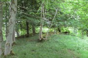
Tongue House chambered cairn amidst the trees
I approached this by walking along the B8438 road northwest out of Tongue village, towards the road-crossing over the Kyle of Tongue. There’s a small tiny road on the right (easily missed) nearly a mile out, just as the road starts to bend, which leads you down to Tongue House. Go along here for about 325 yards (300m) and just as the road bends to the left, walk into the woods. Keep straight forward, following the low-level stream, and when you see the buildings ahead of you, veer diagonally upslope until you hit the large Tongue Burn. Cross this and walk uphill to the tree-covered knoll ahead. You’re there!
Archaeology & History
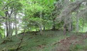
…and again, looking north
From the descriptions I’d read of this site, I wasn’t expecting much at all—but it was much better than I anticipated, and in a beautiful woodland setting too. Admittedly the site is much overgrown, but the overall size, edges and outline of the tomb is easily discernible. In pacing across it, from outer-edge to outer-edge, it measured 18 yards by 19 yards across. All round the edges are many overgrown tumbles of smaller rocks which obviously had been part of the cairn in previous centuries; but it is primarily defined by the larger earthfast rocks at the very top of the natural knoll in the trees, all of them covered in deep mosses.
The site was first mentioned in James Horsburgh’s (1870) survey of the region. He explored a small section of the monument and, upon digging, found a chamber therein—defined by Audrey Henshall (1963) as “a single compartment chamber”—telling us:
“A little to the south of Tongue House, and near the fountain head that supplies it with water, there is the chamber of a cairn of the same description as that near Skelpick, but rather smaller; on clearing it out, I found that one of the large upright stones had two holes bored artificially a short way into each of its sides, but not quite opposite, the holes were about 3 inches diameter.”
However, these internal structures have not been seen since and in Henshall & Ritchie’s (1995) catalogue of Sutherland’s giant tombs, there is some confusion over the definition of the structure itself, questioning whether or not it was indeed a chambered tomb.
“The ‘chambered cairn’ is a circular stone structure overgrown with small trees and covered in leaf-litter and moss. A kerb about 15m in diameter can be traced for much of the circuit. The kerb is of unusually substantial and closely-set boulders which have the appearance of the base of a massive wall such as is inappropriate for a dun or a broch rather than a cairn. The interior is filled with loose stones including some quite large boulders, roughly to the level of the top of the kerb. There is no indication that these boulders have formed part of a neolithic chamber or that the structure was a cairn. There seem to be three possibilities: that the structure is not Horsburgh’s cairn; that the structure is that which he investigated but that he was mistaken in regarding it as a chambered cairn; that the writers are mistaken in identifying the structure as a ruined broch or dun.”
Despite this, the general consensus today is that the monument is indeed a chambered cairn.
References:
- Henshall, Audrey S., The Chambered Tombs of Scotland – 2 volumes, Edinburgh University Press 1963 & 1972.
- Henshall, Audrey S. & Ritchie, J.N.G, The Chambered Cairns of Sutherland, Edinburgh University Press 1995.
- Horsburgh, James, “Notes of Cromlechs, Duns, Hut-circles, Chambered Cairns and other Remains, in the County of Sutherland“, in Proceedings Society of Antiquaries, Scotland, volume 7, 1870.
- Royal Commission on Ancient & Historical Monuments, Scotland, Second report and inventory of monuments and constructions in the county of Sutherland. HMSO: Edinburgh 1911.
© Paul Bennett, The Northern Antiquarian