From the centre of Stoke head west onto Glebe Street and just a couple of hundred yards or so south of the town hall is the minster church of St Peter Ad Vincula (St. Peter in Chains). Go into the large graveyard and there the ancient Saxon cross-shaft stands behind some modern iron railings. There are many other things of interest to see in the churchyard, including some old arches and monuments / gravestones in memory of some famous potters that made Stoke famous during the industrial revolution.
Archaeology & History
The Mercian cross-shaft stands 4 feet high on a 19th century square, socketed lump of stone. It is said to date from about AD 1000 when it was in use as a preaching cross, but could in fact be from earlier than that according to some local historians – perhaps it was originally a Christianized stone. The first Saxon settlement at Stoke (Stoiche) was said to date from c 800 AD. The cylindrical shaped shaft was discovered in 1876 by a gravedigger who spotted it being used as a door lintel inside the old church which was being demolished to make way for a newer church building. During its recovery the shaft broke in two so it was placed in storage, but in 1935 it was formally identified by Mr Charles Lynam who had it restored and re-erected in the churchyard.
Sadly the shaft is quite badly eroded with the carvings on one side being difficult to make out, but the front face has interlacing and scroll-work; there is some key-patterning on the sides and reverse side along with a series or section of small holes – these perhaps done in more recent times. The break across the middle of the shaft can still be seen today, but that does not detract from its great antiquity, the ancient monument being carefully restored. On the base there is an inscription that reads:
‘This fragment of a pre-Norman cross identified by Chas Lynam F.S.A. was re-erected near to its original position in the 25th year of the reign of H.M. King George V by P.W.L.Adams F.S.A.’
Within the Harris Museum, Preston can be found the Upper section of a pre-Conquest stone ‘cross’. Though much damaged on three of its sides the main face displays the upper section of a horned-helmeted figure holding a sword before it. The spreading horns suggest an important figure from the Viking period in Lancashire (c.900). This large and important piece of sculpture was found during the construction of Rivington reservoir on the River Yarrow near the village of Grimeford, Anderton in the 19th century.
Also found at that time during the reservoir construction was the lower section of a ‘cross’ shaft. This shaft is decorated on all four sides with carvings which include: the figure of a man from the waist down; a trellis filled with geometrical ornamentation of horizontal and vertical straight lines repeated to form a band known as a fret; a modified version of T-fret; and a combination of vine scroll and frets. The top of the shaft serves as the base for what is possibly a post medieval sundial base which has been adapted for use as a direction stone with directions to “Preston, Wiggan, Boulton, and Blagburn” (spelled as on the stone) being carved on the sides. I would suggest that the two fragments are parts of the same monolith and may even depict the Viking Gunnolf (the latter being my own fancy). This headless ‘cross’ is sited at the junction on the old road near the Millstone pub in Anderton and Grimeford Lane on the way to Rivington (SD 618 130). The stone is known as the ‘Grimeford Headless Cross’ or more locally as the ‘Headless Boggart’.
Folklore
Legend has it that there used to be a chapel near the junction and a tunnel running to a nearby farm on a hill. In the 16th century shortly before troops came to destroy the chapel, a priest hid in the tunnel and became trapped underground. His body was never found. Many people are said to have seen a ghost at the Headless Cross.
Addenda
To complement John’s entry, here are Mr Taylor’s notes written more than a hundred years ago in his Ancient Crosses and Holy Wells (1906), where he told:
“The HEADLESS CROSS — These words appear on the ordnance maps at a hilly spot in the extreme south-eastern corner of the hundred, five hundred feet above sea level, and distant one mile from the village of Adlington and about the same distance north from Blackrod. Both villages have histories going back into the far past… A ‘Windy Harbour’, near the cross, sufficiently indicates the breezy nature of the situation. The well and the ancient stocks are shown in close proximity to the cross. The remains of the stocks are still in existence.
“Respecting the Headless Cross and others in this locality, Mr J.W. Crompton of Rivington Hall, writes (February, 1899):
“‘In reply to your note, I never heard of any cross, ancient or modern, in Rivington proper. There was a tenement known as Butter Cross. Possibly some ancient cross may have existed there, but I know of no record to it. There used to be a Headless Cross in Anderton, but old Mr Ridgeway, of Ridgemont, removed it many years ago, when he had sporting rights rented in that township, and I believe and old road surveyor broke up a cross in Anglezark to repair his roads early in this century: his name was Gerrard. Crosses seem to have been specially erected to warn people of dangerous moors they were about to cross, and as a call to prayer in this part of the country, they were frequent.’
“…The subjoined deed is printed in the Chartulary of Cockersand Abbey, circa 1184-1190:
‘Grant in frankalmoign from Ranulf Gogard and his heirs to God [and the canons of Cockersand] for the health of the souls of his mother and his wife Edith, of all the land from Fulford to the path which crosses Rascahay Brook, between Heath Charnock and Adlington, as it was marked out by the crosses and marks of the said canons; with comon right of Charnock, in wood and plain, feeding grounds and mast in all other liberties.'”
References:
Taylor, Henry, The Ancient Crosses and Holy Wells of Lancashire, Sherratt & Hughes: Manchester 1906.
Dead easy to find. Get to the centre of Whalley and walk into the churchyard. Don’t confuse it with the ruins of the old abbey, or you won’t find the place!
Archaeology & History
I here wish to draw your attention to the three standing crosses in the churchyard (the crosses do not stand in their original positions having being ‘thrown down’ during the Commonwealth and used amongst other things as farm gate-posts):
1) THE EASTERMOST CROSS (Taylor ‘C’): Standing opposite the chancel door (Priest’s Door, early 13th century retaining the original ironwork and bronze head knocker) is a much-worn cross shaft that only under certain lighting conditions that can any decoration is made out. It has scrollwork as pat of its ornament and a pelleted border. Two figures, heads surrounded by halos, can be made out just above the shaft centre. The head of the cross is not original but of the late 14th century. The cross originally stood over 11ft in height (see drawing reconstruction). Fragments of this cross are built into the fabric of the church, the top section of the shaft and parts of the cross head are held in Blackburn Museum. One fragment can be made out in the outside Chancel wall displaying the pelleted border and some scrollwork. Another fragment is built into the back wall of the Sedilia and is in good condition. A further fragment is built into the back wall of the Bishops Throne, last stall, south side, east adjacent the Sanctuary.
The shaft is set in a broken oblong base that one may have held two or more shafts in the form of a ‘Calvary’.
Cross no.2 in 1904 (after Taylor, 1906)
2) THE WESTERMOST CROSS (Taylor ‘A’): Originally panelled crosses of this type were brightly painted in red, yellow, green, blue and white. All four sides are decorated but only the east face survives clearly enough to be made out. The shaft was divided into seven panels with roll-mouldings running along each of the panels, of which only six now exist (part of the upper panel, displaying the hallowed head of a figure and cross arm are held by Blackburn Museum). The two lowest panels and the top panel contain geometric and interlace patterns. Halfway is a sculptured panel containing a hallowed human figure, arms akimbo (raised as if giving a blessing). Either side of the figure are two serpents with open mouths. This design is repeated on the side face of the shaft along with two interlace panels. Above the figure panel is one depicting the figure of a bird (an eagle or pelican in her piety?). The lower panel shows that of a beast (a dog or a lion?).
Crosses 1 and 2 clearly show Hiberno-Norse influences, so named after the second and third generation Irish Norwegians who settled Lancashire in the 10th century whose artistic culture became dominant.
Cross no.3 in 1904 (after Taylor, 1906)
3) THE CROSS OPPOSITE THE PORCH (Taylor ‘B’): This magnificent cross is in a fair state of preservation, although a portion of the upper shaft and three arms of the head are missing. Originally it would have stood at around 10ft in height and is the oldest of the crosses being no later than the late 10th century. The central cross shaft measures approximately 2.2m high and is socketed into a square base stone carved with dog-tooth decoration. It is rectangular in cross section and tapers towards the top where it has been broken. A piece of the shaft about 0.75m in length is missing. All four sides of the shaft depict well-preserved late 10th century decoration comprising foliated scrollwork. The principal ornamentation is on the east and west faces and consists of a central rounded shaft or pole rising from the apex of a gable. At the top of the shaft are the mutilated remains of the carved central boss of the cross head.
Whalley’s Cross 3
The central rounded column forms the axis mundi (cosmic axis, world pillar), being a ubiquitous symbol that crosses human cultures. The image expresses a point of connection between the heavens and earth where the four compass directions meet. At this point travel and correspondence is made between higher and lower realms. Communication from lower realms may ascend to higher ones and blessings from higher realms may descend to lower ones and be disseminated to all. The spot functions as the omphalos (navel), the world’s point of beginning.
The axis mundi image appears in every region of the world and takes many forms: a hill or mountain (Pendle), a tree (Tree of Life, World Ash Tree, etc), a vine, a ladder (Jacob’s Ladder), a stone monolith, a maypole, Sufi whirling, etc. The foliated swirls represent interactive movement along the axis – transmission, unity within multiplicity.
The axis mundi concept has its origins in Indo-European shamanism, and a universally told story is that of the healer traversing the axis mundi to bring back knowledge (benefits/blessings, etc) from the ‘other world’. The Sufi concept of baraka and the Hindu mystical concept of akasha are akin to this.
All three crosses had cross heads of four arms of equal length, each widening at the outer end in an axe shape so that their rims nearly form a circle.
Editor’s Note: Henry Taylor (1904) described the “remains of other pre-Norman crosses” at the point marked ‘D’ on his map of the church, adding:
“The Bishop of Bristol thus describes the fragments of other crosses at Whalley: ‘A pretty and delicate fragment forms part of the back of the sedilia; there is at least one piece in the south wall of the chancel, outside, and there are fragments lying on the ground. One of these, showing a system of oval buckles, as it were, with straps through them, closely resembles a stone found — but now lost — at Prestbury…”
Folklore
Taylor mentions how the Whalley crosses were long known as the Paulinus Crosses, “who is said to have been made Archbishop of York in the year 627, and who, it is alleged, preached and baptised in the wild districts far removed from that capital, even in such remote places as Whalley… His name is also attached to an ancient cross…on Longridge Fell.”
References:
Taylor, Henry, The Ancient Crosses and Holy Wells of Lancashire, Sherratt & Hughes: Manchester 1906.
Whitaker, Thomas Dunham, An History of the Original Parish of Whalley and Honor of Clitheroe, Nichols, Son & Bentley: London 1818.
The well can be reached along a narrow country lane to the east of the A6 road, some 3-4 miles north of Preston. Fernyhalgh is a tiny hamlet between the villages of Broughton and Grimsargh with pleasent countryside on all sides. The holy well of Our Lady is in the garden of a house with a Roman Catholic chapel and pilgrimage centre at the side of a secluded country lane; entrance through a little gate.
Archaeology & History
Our Ladys Well, Fernyhalgh
There was a chapel on this site way back in 1348, and the spring itself is obviously a pre-Christian one with its dedication to Our Lady – St Mary the Virgin. According to the legend, in about 1471 a merchant sailing across the Irish sea was caught in a terrible storm; afraid that he was going to drown he prayed to the Virgin Mary and vowed that if his life was saved he would undertake some work of devotion to her. Soon the storm cleared and he found himself washed-up but safe on the Lancashire coast but he himself had no idea where he was. At that moment a heavenly voice spoke to him and told him to find a place called Fernyhalgh and there build a chapel at a spot where a crab-apple tree grew – the fruit of which had no cores, and where a spring would be found. He began to search around for this sacred place but no matter how much he tried he could not find the place.
The merchant found lodgings in Preston and, was about to give up altogether, when he overheard a serving girl at the inn. She started to explain why she was so late on arrival. She went on to say that she had had to chase her stray cow all the way to Fernyhalgh. He asked her if she could take him to this place. In a short time he discovered the apple tree with fruit bearing no cores and beneath it a spring and also a lost statue of the Virgin and child. The merchant began to build a chapel close by in memory of Our Lady and soon pilgrims were visiting the holy well and receiving miracles of healing. However, during the time of persecution from the reign of King Henry VIII and through to the reign of King Edward VI the well was abandoned and left derelict; the chapel itself was demolished.
The holy well of Our Lady was fully restored in the late 17th century and a new chapel was built in 1685 when persecutions towards Catholics had eased. Again, the place became a place of pilgrimage and many miraculous cures were being recorded there; the chapel (which is now built onto a house) being used by religious sisters as a place of retreat. Today it is a renowned Roman Catholic pilgrimage centre with thousands of visitors coming from far and wide. The holy well stands within a rectangular enclosure with steps descending down; the well itself being a small-square shaped basin overlooked by a niche inside which stands the Virgin Mary holding baby Jesus. It is very well cared for by the Catholic community with flowers usually adorning the site during the Summer months. Coins are often thrown into the well, though it is not regarded as a “wishing well”. Visitors are always welcome and, you don’t have to be a Catholic, everybody regardless of what persuasion you are can visit the well.
In the 19th century a fragment of an Anglo-Saxon cross was dug up in the grounds of Alkincoats Hall between Colne and Foulridge — this area was probably once an early Medieval settlement that was taken over by Knights Hospitallers in the 12th and 13th centuries. However, the carved cross-head was lost for a long period of time but was thought to have come to light again in more recent times when the sewerage works were being built at Swinden on the boundary between Colne and Nelson. If the cross had stood at Swinden then it almost certainly marked the boundaries between Colne and Marsden (Merclesden).
This fragment was thought to be almost certainly the same as that found at Alkincoats Hall. The piece of cross-head would have adorned the top of a late Saxon or early Medieval cross-shaft dating from the 10th-11th century. The carvings of knotwork interlacing on the arms and central boss were thought reminiscent of Anglo-Norse work — similar to the crosses at Whalley and Burnley.
I believe that the cross fragment was housed in St Bartholomew’s parish church at Colne, but I don’t know whether it still resides there. What a shame that the shaft has long gone – because almost certainly it would have looked resplendent.
References:
Byrne, Clifford H., “A Survey of the Ancient Wayside Crosses in North East Lancashire,” unpublished manuscript, 1974.
Taylor, Henry, The Ancient Crosses and Holy Wells of Lancashire, Sherratt & Hughes: Manchester 1906.
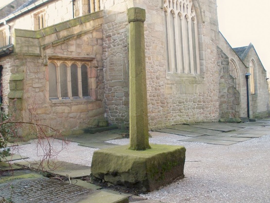
At the north side of St Bartholomew’s church-yard, Colne, stands the medieval Emmott Cross or Touch Cross. It was re-erected here in 1967 by local historian Mr Wilfred Spencer and a team of volunteers having being removed from the grounds of Emmott Hall, Laneshawbridge, when the old hall was being pulled down. The cross had stood for centuries close to the famous Hallown Well, both of which were highly venerated by pilgrims travelling between Whalley Abbey and Yorkshire. It appears that originally the cross had stood at the side of the Stanbury to Haworth road over Herders, close by Emmott.
The cross shaft stands 7 feet tall and is referred to as of the English Gothic style, probably 13th century. It stands in an octagonal socketed stone base which is 2 foot high and 4 foot square. Its slender octagonal shaft tapers away towards the top where there is a carved capital or corona – this may once have held a cross head or some other religious object. There used to be some faint lettering on the shaft but this has now worn away. A local historian Dr Whitaker described the lettering as “I.H.S.” along with the Greek omega symbol.
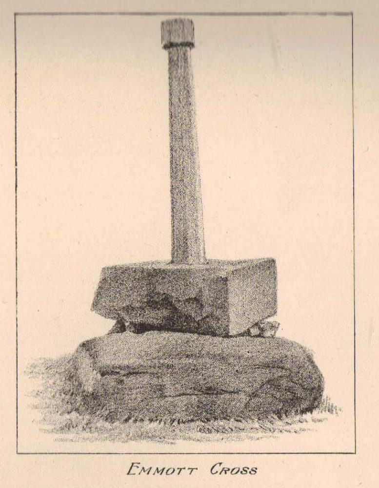
Taylor’s 1906 sketch
It was to all intent and purposes a preaching cross to which pilgrims would congregate and listen to the word of God and many would be baptised in the Hallown Well at the same time. In the penal times of the 16th century the cross was in great use, but by the 17th century it was being referred to as a “papist cross”. During this period in history it suffered damage and the shaft broken in two places; the cross-head taken away and smashed. For safety reasons the cross-shaft was removed to Colne church-yard but returned to the grounds of Emmott Hall in 1728 when relative calm had returned.
The slender cross shaft and its hefty base are said to weigh about 2 tons and I have no doubt it does. It is now grade 11 listed.
Folklore
The name Touch Cross probably comes about in the sense that pilgrims touched the cross in the hope of a safe pilgrimage, or the name may be something to do with a troop of soldiers who were stationed at the hall in the past. They touched the stone too, but for different reasons – that they would live to fight another day in battle.
References:
Byrne, Clifford H., “A Survey of the Ancient Wayside Crosses in North East Lancashire,” unpublished manuscript, 1974.
Taylor, Henry, The Ancient Crosses and Holy Wells of Lancashire, Sherratt & Hughes: Manchester 1906.
Whitaker, Thomas Dunham, An History of the Original Parish of Whalley and Honor of Clitheroe, Nichols, Son & Bentley: London 1818.
It is best to start at the Punch Bowl Inn car park, Sefton, then travel a short distance along Lunt Road by St Helen’s church. A footpath/lane is reached where a barrier stands and about 10 metres opposite the main road beneath the undergrowth is St. Helen’s holy well, or what remains of it.
Archaeology & History
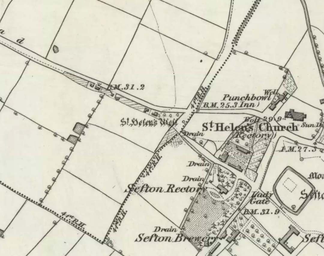
St Helen’s Well on 1850 map
The well is now, sadly, capped off with an inscribed stone that recalls ST HELEN’S WELL. The well originally stood inside a rather nice little wellhouse with a pyramid-shaped, overlapping roof, with railings running around it. It was renowned for its icy waters which were especially good for people suffering from rheumatism, sprains, bruising and, also nervous problems. It had a hand pump at the side of the well-house to enable people to drink the water. But all this has now gone, though the church congregation still visit the site on the saint’s feast day and are still hoping that some day the well will be restored again.
It was probably a pre-Christian spring that in the Middle Ages turned into a pilgrimage site, especially so in the 14th century when the church was built close by.
Folklore
In pre-Reformation times it was much in use, but later on and in more recent times it had become a wishing well; pins were thrown into the well by young folk. Apparently, if the pin could be seen at the bottom of the well a favourable outcome was likely with regard to good luck in a forthcoming marriage by a couple much in love.
Addenda:
To complement Ray’s entry, here are Mr Taylor’s notes from his Ancient Crosses and Holy Wells (1906), in which he wrote the following:
“This celebrated spring rises at a distance of three hundred yards in a westerly direction from Sefton Church. In the year 1891 the well was walled round, and a handsome canopy placed over it, from the designs of Mr John Douglas, at the cost of William Philip, fourth earl of Sefton. The traditions connected with this holy well are thus graphically summed up in the History of Sefton:-
“”We must not omit to mention St Helen’s Well, which springs near the first cottage in the Thornton Road, beyond the inn. Formerly a ‘pad-road’ only led from the well to the church, the Thornton Road passing through the Rectory grounds. In the Churchwarden’s accounts we find several items of expenditure incurred for the keeping in order of St Helen’s Well. Thus we read in 1758: ‘For a new Dish and Chain for S. Ellen’s Well, 2/-.’ Ashcroft [writing about the year 1819] tells us ‘that this well was once in great repute for curing rheumatism, strains, bruises and weaknesses of the nerves. It has no mineral quality, however, and he remarks that its principal virtue seems to have been its coldness.’ In different times great respect was paid to wells ’eminent for curing distempers upon the Saint’s Day whose name the well bore,’ and it was once the custom to decorate the wells of Holy Thursday with boughs of trees, garlands of flowers, etc, places in various devices, and after service in the church the parson and singers repaired to the well, where they sang psalms and prayed. The bottom of the well, which is of no great depth and very clear, may generally be strewn with pins which are dropped in by superstitious young country folks to denote to them the probability of their marriage, which is said to be near if the pin falls pointing towards the church. Pins and pebbles were often dropped into wells, and the circles formed thereby on the surface of the water (or the question whether the water was troubled at all) were used as omens by which the observers drew inferences of future events. Mr Hampson, in his Medii Ævi Kalendarium, says: ‘I have frequently seen the bottom of S. Helen’s Well, near Sefton, Lancashire, almost covered with pins, which I suppose must have been thrown in for like purposes.'”
“…Mr Gregson wrote: ‘With regard to the curious frequency of well dedication to S. Helen, I formed a theory many years ago that the S. Helen of the county of Lancaster is not unconnected with the Celtic S. Elian, who is a frequent patron saint of wells in North Wales. Do they not both draw a common ancestry from Ella, the water sprite?'”
References:
Caroe, W.D. & Gordon, E.J.A., Sefton: A Descriptive and Historical Account, Longmans Green: London 1893.
Taylor, Henry, The Ancient Crosses and Holy Wells of Lancashire, Sherratt & Hughes: Manchester 1906.
Although this great and legendary cathedral is today a christian centre, it seems that the site had been deemed as sacred by a much earlier, indigenous culture — though on a scale much more humbling than the grand edifice we see standing here today! For in the northwest corner of the church grounds in 1928, a small burial cist was located. Years later, on October 2, 1975, following work here by the North of Scotland Hydro-electric Board to uncover the main supply “in an area adjacent to the north wall of the Lady Chapel,” they found a slab of stone which, when they lifted it up, covered what appeared to be a burial cist. Messrs Gordon & Gourlay (1976) narrated:
“The stone slab which the workmen had removed proved to be the western section of a larger slab which at some period had been fractured and the eastern section lost. As the interior of the cist was filled with soil similar to that surrounding it and containing a considerable quantity of dispersed human bone fragments, it was suggested that the eastern section of the covering slab had been lost when the drainage and/or electricity services were being installed. The upper surface of the slabs western section was c.35cms below ground surface. The dispersed bones in the cist were at first considered intrusive — possibly from old burials when the public services were installed — and an undisturbed deposition of bones at the base of the cist seemed to confirm this. However, an examination of the bones by Dr A. Young…and Dr D. Lunt…showed that the deposit contained remains of two adults and one child and that many of the dispersed bones could be matched with those in the undisturbed group. In fact, the deposition suggested a re-use of the cist.
“The cist measured internally 1.20m by 0.44m by 0.28m. It lay 8.4m east of the door of the Lady Chapel and 1.44m from the wall of the same. The cist was constructed from ten irregularly-shaped sandstone slabs, with one fractured slab forming the floor. On the south side, two smaller slabs had been placed on the inside of the wall to support the covering slab which only just fitted the cist, and to give extra strength to the wall since they overlapped the vertical joins of the three slabs of the south wall. The north wall slanted to meet the west-end slab 12cm from its edge, giving the cist a coffin-like appearance. The north wall was still vertical; the narrowing was probably intentional as the covering slab was only 33cm wide at that point and the bones lay apparently undisturbed, parallel to the north and south walls. It proved impossible to examine the old ground surface because of the public installations, but it did appear that the ground sloped to the west as the cist certainly did.”
Although the remains found here were not dated, it was initially thought that the cist may have been made around the period when the Lady Chapel was erected around 1250 AD.
“However, Mr J. Stevenson of the Royal Commission for Ancient and Historical Monuments pointed out that the dimensions and construction of the cist accord well with cists of known prehistoric dates in the area; the cist (therefore) would seem to be placed early in the sequences of cist development, assuming it to be prehistoric.”
References:
Cockburn, James H., The Celtic Church in Dunblane, Society of Friends of Dunblane Cathedral: Dunblane 1954.
Gordon, Alistair R. & Gourlay, Robert B., “A Cist Burial, Dunblane Cathedral, Perthshire,” in Glasgow Archaeological Society Bulletin, No.2, 1976.
Many churches strive to find evidence in the greater antiquity of their foundations than the industrial age; and even those whose origins are medieval hope to find much older roots. Such is the case with this Norman church of St. Peter, where just such an antiquity was found in the middle of the 19th century, embedded in the old walling where it had been encased many centuries before. Thought to have been carved around the 8th century, the design on the stone typifies much ‘Celtic’ art, as it tends to be called, such as are found all over northern England. As we can see here, the main feature is a series of curved and interlocking lines covering most of the rock face (sadly, no swastika occurs on this stone, but it’s common on many others of this period). The old vicar of the church — Harold Rogers — takes up the story:
“About the year 1841, when part of the chancel work was taken down, some fragments of curiously ornamented sandstone were discovered embedded in the masonry. They were carefully removed, put together, and placed in the churchyard where, protected from injury by a glass case, they may now be seen. The carved ornamentation on this ancient relic was probably executed about the 8th century, and it is conjectured that the stone formed part of a cross placed there by some early Saxon converts…to commemorate the spot where the gospel was first preached in this locality.”
A brass inscription attached to the encased carved stone informs the visitor the same information. The proximity of this early carved stone to the River Bollin and, very probably, an ancient ford crossing, implies the waters here were held as sacred in ancient days and hence the supplanting of the ornate carved cross at this position in the landscape.
References:
Rogers, Harold W., Prestbury and its Ancient Church, Arthur Clownes: Macclesfield n.d. (c.1960)
Dead easy this. From Otley, take the north road over the River Wharfe and turn left following the signs to Askwith, where you’ll hit Weston village first. Once here, take the small left turn down to Weston Hall and the accompanying church. Go into the churchyard and check the graves!
Archaeology & History
This is a real curiosity. It’s found in the graveyard of All Saints church, Weston, where one of the graves has several small stones on it, with this small stone with the following cup-and-ring designs upon it. A plaque has been attached to it as a memorial to one ‘Susan Mary Dawson’. Strange…
Sid Jackson’s 1958 sketchCup-marked stone deliberately placed on a christian grave
It was first written about by Sidney Jackson (1957), but where it first came from and why it has been placed here in a christian setting is something of a mystery. It’s also odd inasmuch as although we know that there was some form of ritual or geomantic use of cup-and-rings in relation to neolithic and Bronze Age burials — that such a tradition has been performed by this particular family on this grave. It is obviously highly unlikely that this family had any knowledge whatsoever of burial traditions in relation to cup-and-ring art (please, shoot me down in flames if you know otherwise), so this re-use of this prehistoric stone is likely to be little other than fortuitous. But then, the occult history of some of the influential families in and around this region in relation to witchcraft, ancient kingship and esoteric practices, might indicate otherwise…
Does anyone know anything about the Dawson family history which might throw light on this modern use of a prehistoric tomb marker? It has all the hallmarks of once coming from a prehistoric cairn, but we know little of its history prior to 1957.
References:
Boughey, Keith & Vickerman, E.A., Prehistoric Rock Art of the West Riding, WYAS 2003.
Jackson, Sidney, ‘Cup-and-Ring Boulder, Weston Churchyard,’ in Cartwright Hall Archaeology Group Bulletin, 2:16, 1957.


")
