Tumulus (destroyed): OS Grid Reference – TA 0584 6128
Archaeology & History
Ruston Beacon tumulus on 1854 map
A fallen tumulus that once marked the southwestern side of the village boundary line, and was once adjacent to the prehistoric Green Dikes earthworks that once passed here. Sadly however, sometime early in the 20th century, this ancient burial mound fell victim to usual ignorance of arrogant land-owners who place money ahead of history and local tradition and it was ploughed-up and destroyed. Thankfully we have an account of the site in J.R. Mortimer’s (1905) incredible magnum opus. Listing it as ‘Barrow no.272’ in the number of tombs excavated, he told us that:
“It is situated on elevated ground about half-a-mile (south)west of Ruston Parva. On September 20th and 21st, 1886, it measured about 70 feet in diameter and 2 feet in elevation; and had originally been several feet higher, as an old inhabitant remembered assisted in removing its upper portion, which was carried away and spread on the surrounding land many years previously. At the base of the barrow, near the centre, was a long heap of cremated bones which had been interred in a hollow log of wood with rounded ends, about 3 feet in length and 14 inches in width, well shown by impressions in the plastic soil, and by the remains of the decayed wood. The heap of bones was rather large and probably consisted of the remains of more than one body. No relic accompanied them. Several splinters and flakes of flint were picked from the mound.”
The tumulus (as its name implies) became a spot besides which one of East Yorkshire’s many ancient beacons were built. In Nicholson’s (1887) survey of such monuments, he told that
“the modern beacon, apparently, stood on the site of the old one, on the high ground in the angle of the road from Driffield to Kilham. It was a prominent object and would be well-known to the coachmen and guards…for it stood on the side of the road from Driffield to Bridlington. Mr John Browne, of Bridlington, remembers it; and says, ‘It would be the last of the beacons that remained in this district and was removed between fifty and sixty years ago. My recollection of it is that it was a tall pole, with a tar barrel at the top, and had projected steppings to reach the barrel.”
One of the earliest accounts of the beacon from the late-1500s told that it took signal for its light from the beacon at Rudston, which stood upon one of the Rudston cursus monuments, a short distance from the massive Rudston monolith.
References:
Mortimer, J.R., Forty Years Researches in British and Saxon Burial Mounds of East Yorkshire, Brown & Sons: Hull 1905.
Nicholson, John, Beacons of East Yorkshire, A. Brown & Sons: Hull 1887.
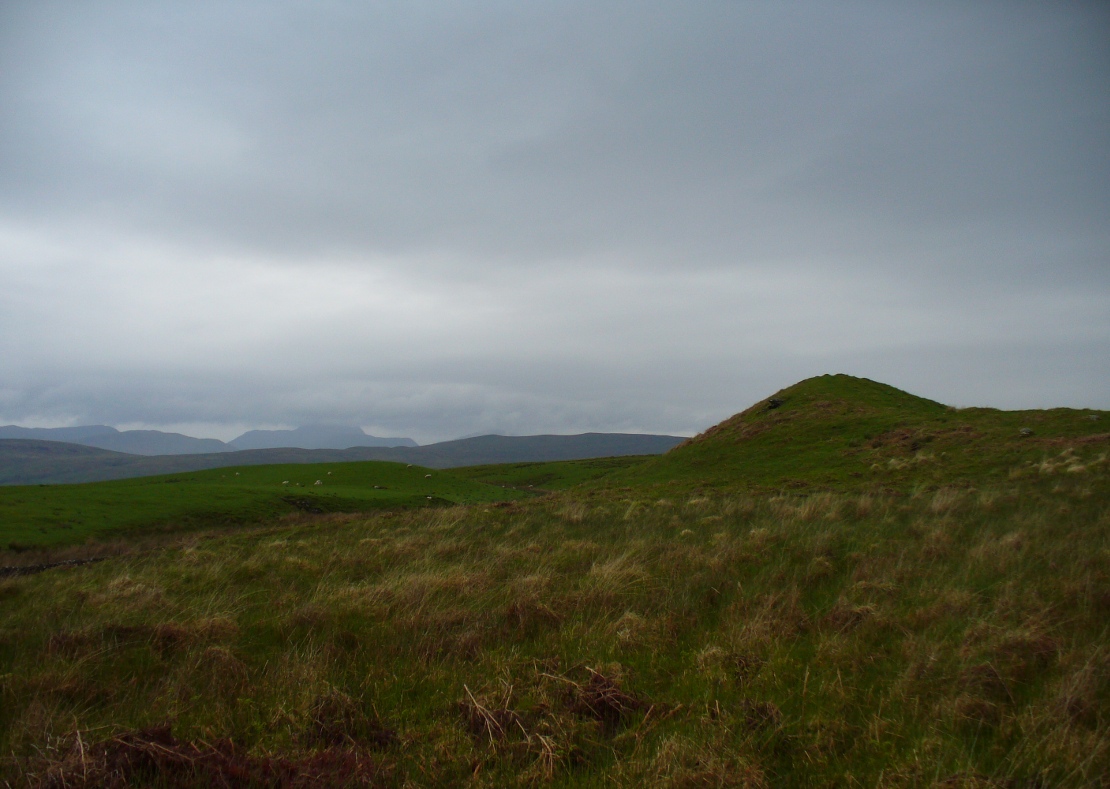
From Kenmore, take the minor road on the south-side of Loch Tay for 1½ miles (2.4km) until you reach the hamlet of Acharn. From here take the track uphill for ½-mile past the Acharn waterfalls and when you come out on the east-side of the trees, keep walking uphill parallel to the trees and burn until the land levels-out and the track heads away, east. 200 yards ahead, on the left-side of the track, you’ll see the large fairy-mound.
Archaeology & History
The tumulus looking NE
First reported in archaeological circles in the Discovery & Excavation Scotland mag in 1964, this archetypal fairy-mound or tumulus sitting on the grassy plain overlooking the eastern end of Loch Tay and district would have been known of by local people in older times, but I can find no early accounts of it, nor its traditions. When Bob Money (1990) came here, he told of the grand vista stretching into the distant mountains:
“From here the views…are superb, and the little mound, which is an ancient tumulus, or burial mound, has sat here undisturbed for several thousand years, guarding the secret of its once important occupant.”
Circular in structure and measuring 20 feet across, the mound rises nearly four-feet high and is probably Bronze Age in origin. Although mostly covered in grass, there are some loose stones visible on the side of the mound, seeming to indicate that it may be a covered cairn. No excavation have yet taken place here.
References:
Money, Bob, Scottish Rambles – Corners of Perthshire, Perth 1990.
Acknowledgements: Many thanks to the unholy bunch who helped travel, locate, photograph and take notes on the day of our visit here, including Aisha, Lara & Leo Domleo; Lisa & Fraser; Nina and Paul. Let’s do it again and check out the unrecorded stuff up there next time!
Along the A84 road between Doune and Callander, take the tiny country lane up to your right to Drumloist (if you’re coming from Doune) or up the tiny unmarked road past Keltie Bridge on your left (if you’re coming from Callander). Uphill for several miles, you eventually emerge from the trees and are on the top of the tiny road. Once here, keep your eyes peeled for Drumloist farm. Best thing to do is walk up the track and ask at the farm. The fella there is a superb old Highlander who’ll point you to the place on the hill above.
Archaeology & History
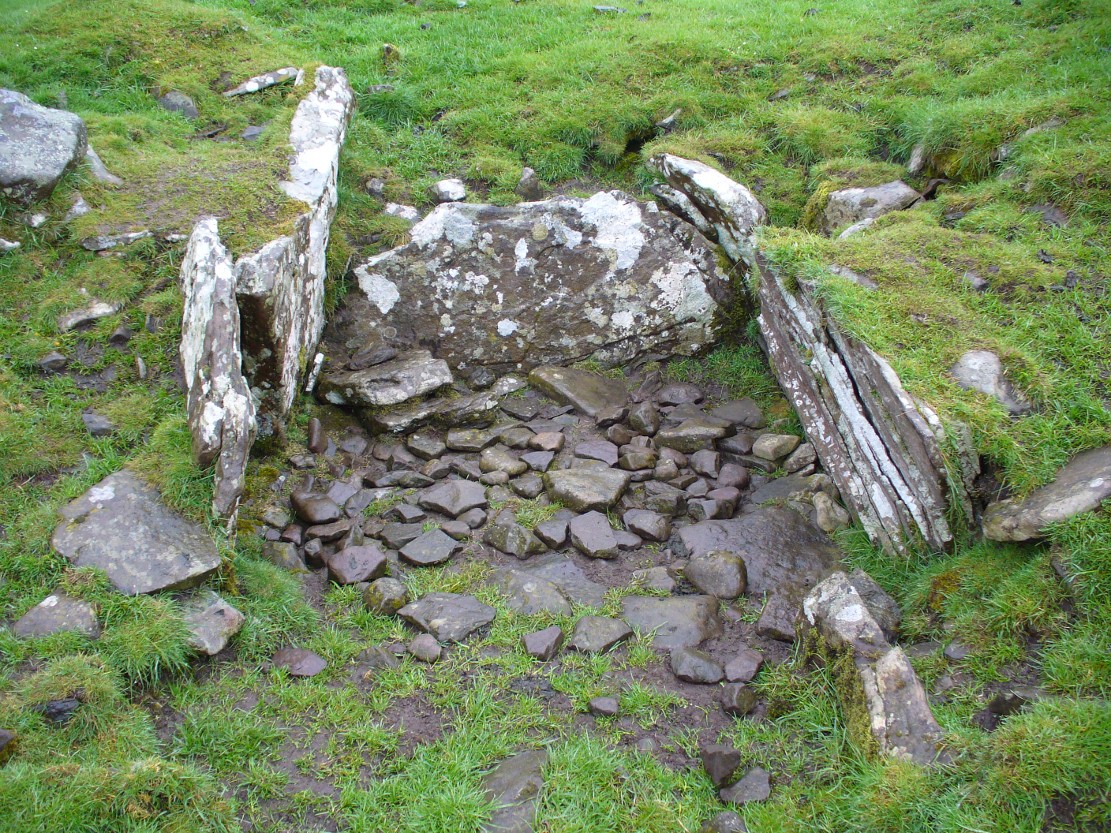
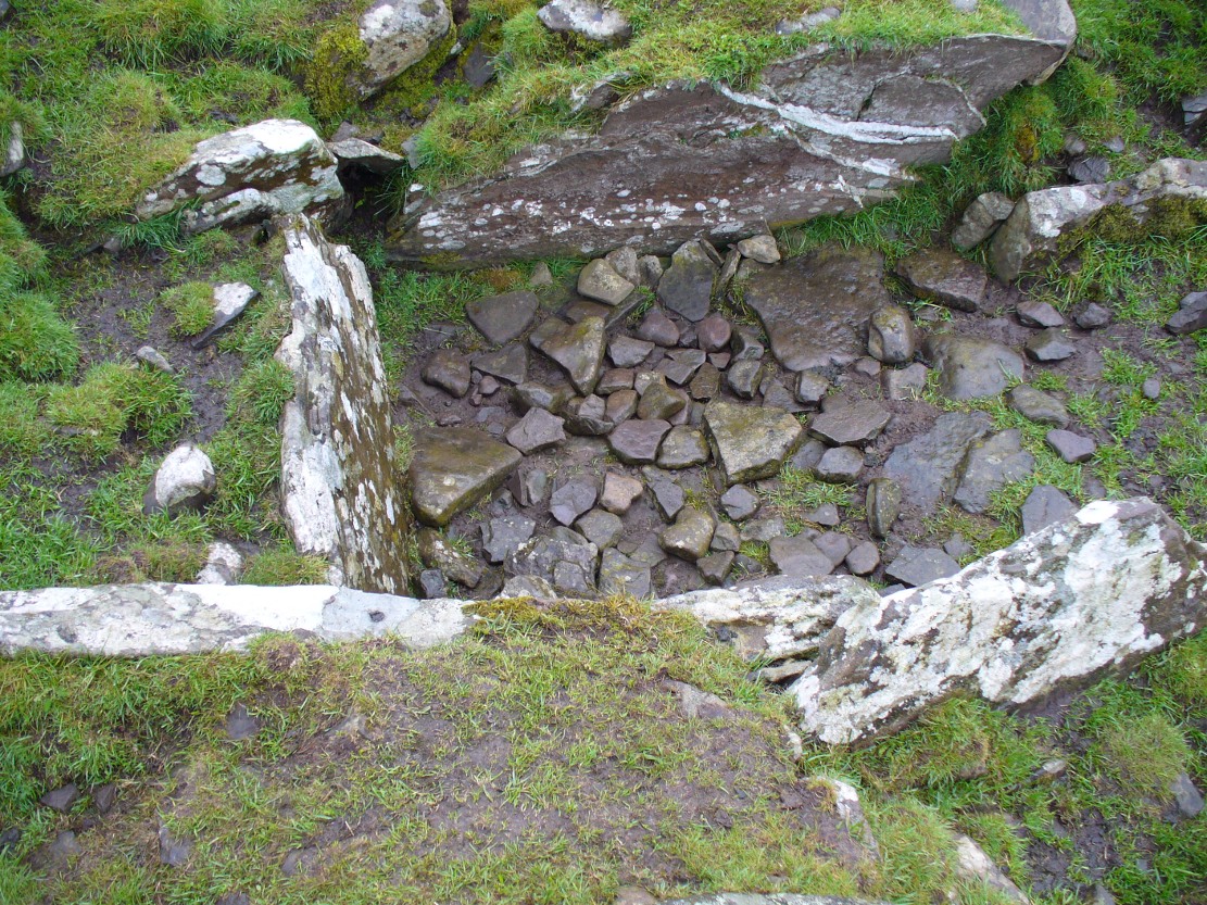
A site that was never explored by that giant of chambered tomb research, Audrey Henshall. A pity, as it has a lot of potential and seems to have a lot more to say about itself than the meagre findings reported by the Scottish Royal Commission doods.
Curious fairy mound to rearOne of two main chambers
Although there’s a very notable “fairy hill” eminence close by which strongly draws your attention, the actual hillock upon which this chambered tomb was constructed is in front of this, closer to the farm. A couple of rows of ancient walling—Iron Age by the look o’things—run up the hillside, with one of them running into the eastern sides of the huge mound which this tomb plays a part in. The mound itself is about a hundred feet across, although seems to have been damaged over the centuries. Although it is probably neolithic in origin, sections of the monument seem to have been altered and re-used for other purposes, giving it that distinctly multi-period look.
The farmer informed us how some of the stones from the mound had been robbed and used in some of the walling in the past. He also told us how there are so many other archaeological features upon the moors above here that remain to be “officially” recorded, despite the efforts of some who swept the region for remains a few decades ago.
Looking into the main cistNature’s faded cup&ring
The main prehistoric section of the tomb that can be seen are the two opened cists, or stone-lined graves, to the top north-western edges of the mound. They align together, NE to SW, with a gap of about three yards between the two open tombs. The more northerly of the two is much more overgrown; whilst the southwestern grave comprises of three large flat upright stones, forming a traditional ‘box’ with smaller flat stones lining the floor. But these two separate tombs (if indeed they were originally separated) point directly to the large, very prominent “fairy mound” about 100 yards north-east, on the north side of the Drumloist Burn. The alignment seems very deliberate.
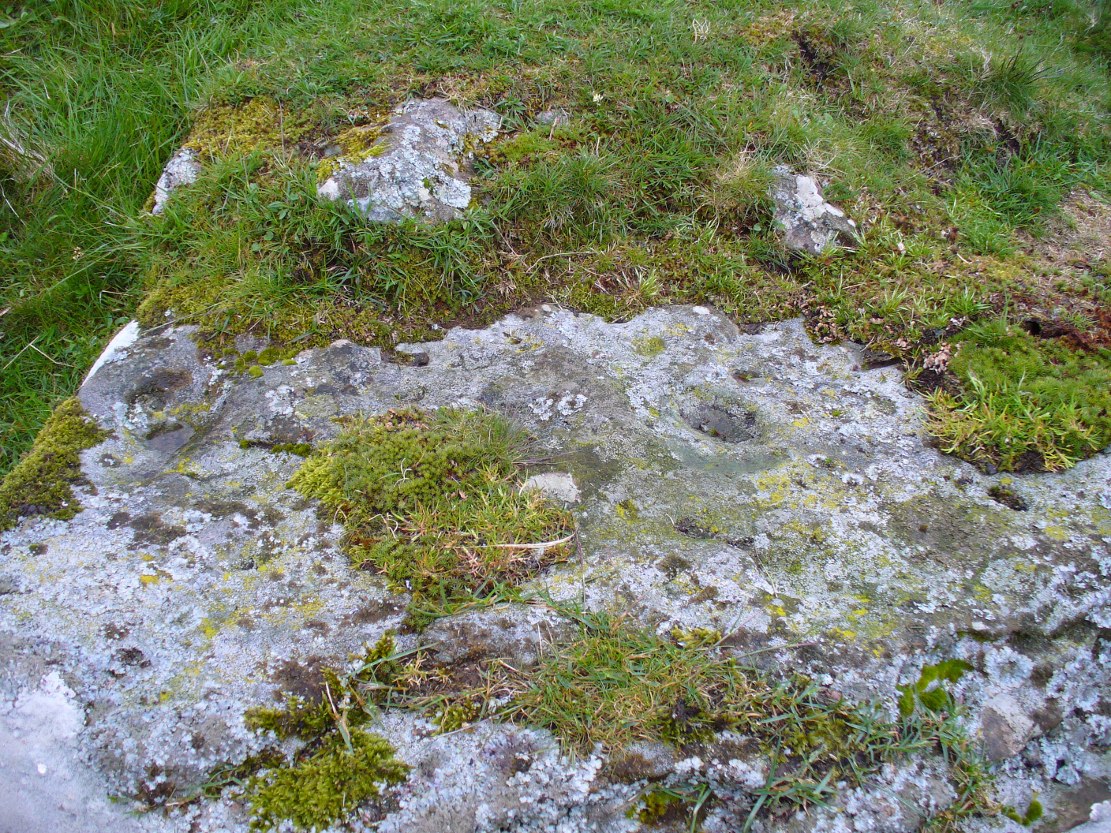
Walking over the boggy ground to the (unnamed) fairy mound, a natural ‘platform’ of rocks sticks out on its south-easterly side, and upon this are what I initially thought were two cup-markings, with the more easterly one of the two seeming to have a carved arc along its edge; but subsequent visits here at different times of day has shown that they are Nature’s handiwork. Anyhow, looking from this mound, back across to the Ballachraggan tomb, the open flat landscape heading south-west is held where the sunset falls. Sadly on the day we visited, Nature greeted us with grey cloud and the drizzle of light rain all afternoon, so we couldn’t make out if there was something, far away, which the tomb was truly aligned with… A damn good site though!
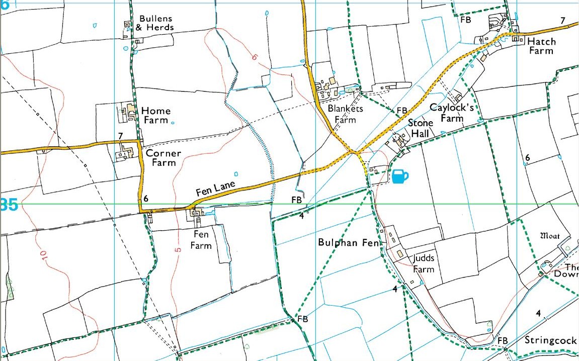
As with many prehistoric sites, this too was unearthed and seemingly destroyed in the 19th century. Although it seems that nothing now remains of the place, the english archaeological fraternity have the site listed as a “Romano-British site”, which seems reasonable; although the lay-out of the barrows or tumuli described and portrayed in the sketch here give a more traditional Bronze Age look. But we may never know for sure. Thankfully a fellow antiquarian called Walter Field (1863) was on hand to make a record of the place before its final destruction. In a short paper he wrote for the Essex Archaeological Society, he told that:
“In the Spring of 1858, a number of labourers were employed in trenching some fields belonging to Holme Farm, forming part of a large tract of land called Bulphan Fen, and situated about a mile-and-a-half west of the village of North Ockenden. In the course of their operations they found a number of beds of dark soil, in which were a large quantity of bones, supposed at first to be human, together with fragments of pottery and pieces of charcoal. It was the general belief among the workmen that the field had been the scene of some great battle, a belief supported by some local traditions. One thing seems certain, that it is the site of a Roman or early British Burial Ground, extending over a space of about sixteen acres; but whether it marks the battlefield of one of those many great struggles which took place in this county between the Britons and Romans, or whether it denotes the peaceful cemetery of a Roman Station, it is perhaps not very easy to determine.
“The little evidence, however, which the plough and the harrow have left remaining, seems in favour of the latter. The regular and almost equidistant arrangement of the lines of dark soil in many parts, and the many fragments of cinerary urns found in nearly all of them, seem to indicate rather the orderly interment of a cemetery, than the more hasty burial of a battle-field; but this is by no means conclusive.
“The graves are at once discernible from the surrounding soil, the natural soil being a yellow clay, whilst the earth of the graves is nearly black. It is impossible, with any accuracy, to trace the exact forms of the graves, some appear to be circular, and to vary in size from 10 to 40 feet in circumference, others appear to be of an oblong form; one grave is much larger than the rest, and is of about 60 feet in length and 20 in width. There are doubtless more of these graves in the bordering fields. It is worthy of note that a neighbouring meadow is called the Church Field, and a portion of the land on which these discoveries were made is still called Ruin Field. Both these names, probably, have reference to the formerly uneven sur&ce of the ground, caused by a great number of burial mounds. The fragments of Pottery vary much in their character, some being of the very rudest workmanship, whilst others have been more carefully manufactured; and a few small pieces of Samian Ware were found; mingled with them, were the bones of different animals — the horse, the deer, the boar, etc., but no human bones; much of the earth, stones, and pieces of wood bear evident marks of the action of fire; beyond these there was nothing found, except a portion of a flint arrow-head and a part of a hand mill stone. Not a single coin or piece of metal was discovered. The circumstances that all the fragments of pottery, and nearly all the bones of animals, are broken up into small pieces lying equally at the bottom as at the top of the dark soil, and that the graves are about three feet deep, narrow at the bottom and widening to the surface, lead me to think that the present graves are only the trenches of the original barrows, but that the field has been gradually levelled for agricultural purposes, and that the plough and the spade have in process of time filled up the original trenches with the soil, urns, bones, &c., of the burial mound.”
References:
Field, Walter, “Discovery of British and Roman Remains at North Ockenden and White Notley,” in Transactions of the Essex Archaeological Society, volume 2, 1863.
This site entry is dedicated to Sarah Hunt, once of North Ockendon, wherever she may be…
Tumulus (destroyed): OS Grid Reference — NT 237 861
Archaeology & History
Very little is known about a prehistoric tomb that once existed near the coast at Craigkennockie. Its existence was briefly described in Andrew Young’s (1913) fine history of the township where he told that it had been highlighted on an old Estate Map of the area and marked as, “an artificial cairn, probably a place of sepulture.” On old maps just below the cited place we find the place-name of ‘Lammerlaws’, which may indicate a name once given to the site, as the element -law is commonly found relating to prehistoric cairns.
Although the modern place-name researchers in central Scotland have opted that the word ‘law’ is primarily “a rounded hill”, they have curiously forgotten or omitted its other derivation. Throughout northern England and beyond, the English Place-Name Society finds that many ‘law’ place-names derive from the old English and Saxon word, hlaw, which is originally told to be “a mound, a hill.” This has been the reference cited throughout in Taylor & Markus’ (2006-2012) otherwise fine multi-volume analysis of Fife county. But there’s much more to it than that. I hope that readers will forgive me reciting A.H. Smith’s (1956) full entry about this simple term, as it can (and many times does) show our history is much richer than initially thought. Prof Smith told that law, hlaw, hlæw, has the following etymological origin:
“(1) In OE (old English) the common meaning in literary contexts is ‘an artificial mound, a burial mound, a mound in which treasure is hidden’, as in Boethius Metr. 10.43, ‘in what hlæwa do the bones of Weland cover the ground?; Beowulf 2802, ‘Bid them make a hlæaw…on Hronesnæsse’; Guthlac 4 ‘there on the island was made a great hlæw, which through the lust for treasure had been dug up and broken into’; or Gnomic Verses 26, ‘a dragon shall be on hlæw’, an allusion (as in Beowulf 2773) to the Germanic tradition that mounds containing valuable grave-goods were guarded by dragons. The word glosses Latin, agger, ‘something heaped up, a mound, a rampart’ (Wright’s Anglo-Saxon & Old English Vocabularies 355.4). This meaning ‘tumulus, artificial mound, burial mound’ is well attested in place-names. According to Grundy, it always denotes a tumulus in the OE charters and doubtless those place-names in which it is combined with personal names are the burial places of the men so named; at Taplow at least a remarkable burial treasure was discovered and Cuckhamsley, Berkshire, is named from Cwichelm, the West Saxon king who died in 593. The majority of such places-names belong to the heathen period when this method of disposing of the dead was practised. Particular compounds also suggest that it could be an artificial mound which formed the centre of a place of assembly; Oswaldslow Hundred (Place-names of Worcestershire, 87), for example, was created in 964 and it was to meet at a place to be henceforth called Oswaldeslaw in honour of Bishop Oswald (Cartularium Saxonica 1135).
“(2) The meaning ‘hill, a conical hill resembling a tumulus’ is also found in OE, as in Leechdoms Vol.3, 52, ‘they rode over the hlæw’, and local topography establishes this meaning as a common one in place-names and dialects in certain parts of the country; it survives as law in Durham and Northumberland and as low in northwest Midlands…
“(3) The two forms hlaw and hlæw are on record, the latter being better evidenced in literary use, especially in West Saxon texts, and the former in place-names; hlæw normally becomes low, north country law, whilst the i-mutated hlæw (found in place-names only in the south and south Midlands) later becomes lew, as in Lew, Oxfordshire, Lewes, Sussex and is more frequent in middle-english spellings; it is often later replaced by –low as in Dragley, Lancs, Cuckhamsley, Berkshire…”
Smith continues with many topographical evidences regarding a ‘burial-mound’ derivation for the place-name ‘law’, finally adding notes on relative linguistic similarities, like the “Gothic hlaiw, ‘grave’; old High German hleo, ‘grave mound, hill’; old Saxon hleo, ‘grave mound’…” It seems pretty convincing, and so we need to take this into account in our walks over the hills if we are exploring ancient history.
As if to emphasize this derivation—’law’ as prehistoric tombs—we find it is cited in the massive Scottish National Dictionary (6,1:16) where—alongside the ’rounded hill’ aspect—Mr Grant (1962) tells it to be,
“An artificial mound or hillock, specif.: (1) a tumlus or barrow, grave-mound….”
thereafter giving a number of Scottish examples. The same meaning is echoed again in the modern version of Concise Scots Dictionary (2005), along with the rounded-hill. Jamieson’s (1885) Scottish Dictionary cites similarly, ‘law’ as both hill, aswell as “a tomb, grave or mound.”
This association of ‘law’ with ancient burial mounds in Scotland should not be that surprising. Despite it having an Anglo-Saxon origin, we must remember that the Saxon kingdom is known to have stretched all the way up to the Firth of Forth (Edinburgh) and across to Glasgow. So if the linguistic roots have any credibility at all, it doesn’t take much stretch of the imagination to have this simple word travel further north amongst the people. Perhaps this is why, more recently, Margaret Gelling (2000) has said that the association of hlaw with burial mounds up here lessens in Scotland. Nonetheless, let us not presuppose one meaningful definition of the word above another, as it can, consciously or otherwise, be seen as more symptomatic of the all too common English attitude of papering over another country’s rich and ancient heritage by depleting its language—again…
(Law has another element attached which has all but fallen out of historical analysis. Prof Smith touched briefly upon it, mentioning ‘law’ as being a meeting place—otherwise known ‘moots’. Moots occurred everywhere in early times: in England, in Europe and in Scotland too. They were originally where local tribal gatherings took place, for the purpose of what we might call council or political decisions, amongst other things. Some of these moots occurred on burial mounds of great age, aswell as stone circles—and evidence indicates that some of them originated way back in prehistoric times. Although written accounts of many such moot spots have fallen from historical texts, the term law or low (and their variants) is again found in Scottish etymological and topographical lore. Mr Grant again cites it to mean:
“Law cairns, or court cairns…the judicial sites of baronial court of justice…”
Thereafter giving numerous citations of its use in both the common tongue and sites where it is known. As far north as the Shetland Isles, where such law-courts aer known from the Scandinavian ting of thing, the 18th century Statistical Account of Tingwall states there being “the Law Stone” at the cite of the parish court.)
Folklore
Also in Mr Young’s (1913) work, he told how this old tomb was a place that seemed cursed or should not be disturbed, saying,
“About 50 years ago, any illness in the neighbourhood of Craigholm was ascribed to the influence of this burial place…”
adding that an adjacent spring of water, of high esteem, was close by.
References:
Grant, William (ed.), Scottish National Dictionary – volume 6, SNDA: Edinburgh 1962.
Jamieson, John, Etymological Dictionary of the Scottish Language, W.P. Nimmo: Edinburgh 1885.
Robinson, Mairi (ed.), Concise Scots Dictionary, Aberdeen University Press 2005.
Smith, A.H., English Place-Name Elements – volume 1, Cambridge University Press 1956
Decorated prehistoric urn from St John’s Green tumulus
In a prehistoric burial mound that was destroyed by the usual self-righteous arrogance of industrialists, this well-decorated urn or beaker in the old photo (right) was somehow retrieved. Included in Dave Clarke’s (1970) major survey on such vessels (as an Abercrombie type A, no less!), the remains came to light in January 1930, “during the laying of a gas main under the west footpath of Flagstaff Road, about 100 yards south of St. John’s Green.” Although the barrow or tumulus had already been levelled, sheer diligence and care on behalf—one believes—of antiquarian M.R. Hull saved the vessel from an otherwise inevitable doom!
In Mr Hull’s (1946) article on to this and other similar finds in Essex, he described how the urn, about seven inches high,
“…stood upright in the side of the trench, only 18in below the surface. The ground had been disturbed before, and one side of the beaker was badly damaged… The clay was fine, but contains some sparse grit, fairly large and white. It is light brown-red in colour and black in the break. The body is decorated all over with impressed lines, some done with the print of a stick or bone, some in an indefinable way which produces an almost maggot-like impression of varying length, and some with the end of a comb, as on the Type B beakers, but the teeth are oblong (very narrow) instead of square—the comb in fact, was very thin, at least at the point.”
References:
Clarke, David L., Beaker Pottery of Great Britain and Ireland – volume 2, Cambridge University Press 1970.
Hull, M.R., “Five Bronze Age Beakers from North-East Essex,” in Antiquaries Journal, volume 26, Jan-April 1946.
Tumulus (destroyed): OS Grid Reference – TM 0628 2022
Archaeology & History
Alresford Hill urn
In a region well known for the finding of early British remains (Belloc 1905), another prehistoric burial mound was destroyed in the Essex landscape simply due to ignorance and neglect. Thankfully once more we have local antiquarians and an astute schoolgirl for discovering and preserving a record of this site, otherwise we’d have no record of the place at all! Described in M.R. Hull’s (1946) article on some of the Bronze Age relics of the area, he told how a well-preserved urn in the edge of the tumulus,
“was found in June 1942 by a schoolgirl, Miss Anne Pilkington, on the top of the hill overlooking Alresford Creek and the Colne Estuary, about 70 yards northwest of Bench Mark 74.8 and 560 yards slightly west of south from Alresford church, west of the road to the creek and south of the lane running west along the north side of the field. This is the northern limit of a huge gravel-pit. She noticed the vessel standing upright in the side of the pit and recovered it. Nothing else was noticed…
“Afterwards the diary of our late Fellow, Mr P.G. Laver came into my hands and I find under the date 8th July, 1922, that he noticed, when motoring past the site, ‘a definite tumulus, but much ploughed down, now barely 18ins above the field level. It is close to the road through the field, the centre being roughly 20 yards S of the road and about 200 yards from the road to the ford.’ The sketch-plan leaves no doubt on the identity of the site.”
Annoyingly though, Mr Hull didn’t think it worthwhile to reproduce this alleged sketch-map. He did however give us a good description of the urn and its position in the ground, saying,
“The vessel is stated to have been about 5ft below the surface when found, but I am not certain whether the top-soil had been removed or not. The clay is fine, burnt light red, but black within, and the whole body is covered with horizontal lines impressed in exactly the same way as (those on the Flag Inn urn), but much less clearly. The base is slightly hollowed beneath and is not far from having a foot-ring.”
Folklore
Mr Hull (1946) also made an interesting comment on the views of local people about the site where Anne had found this urn, reminding me of what Highland and hill folk would have put down to faerie-lore, though no such memory was noted. He told:
“On enquiry I learnt that no one had observed a mound at the spot, but that it had been observed that exactly there the corn, when the field was cultivated, grew taller and greener in a large round patch”!
References:
Belloc, Hilaire, The Old Road, Archibald Constable: London 1905.
Hull, M.R., “Five Bronze Age Beakers from North-East Essex,” in Antiquaries Journal, volume 26, Jan-April 1946.
Tumulus (destroyed): OS Grid Reference – TM 117 178
Archaeology & History
Bronze Age beaker from the Flag Inn tumulus
Roughly halfway between Thorrington and St. Osyth, a few hundred yards east of the Flag Creek on the grassy wasteland south of the historic Flag Inn, could once be found a fine tumulus, of whose past we sadly know so little. Nothing now remains of the old burial mound apart from a carved urn that once lived therein and was recovered from the site before its final demise. According to M.R. Hull (1946) the well-preserved Bronze Age beaker found here—which he said “stood out as different” from others in this area—
“was found in 1930 on the 50ft contour-line about 200 yards south-southeast of the Flag Inn, in a gravel pit, in St. Osyth parish. The position is a mile and a quarter north-northwest of St. Osyth church. On this occasion it was not possible to examine the site, which could only be established with moderate accuracy some time after the discovery…
“The clay is fine, of light red colour, ornamented with three bands of trellis pattern, each bounded by three horizontal lines, and a band of four such lines at the base, all executed with an instrument making a short line of square impressions, probably the end of a comb used in weaving.”
References:
Hull, M.R., “Five Bronze Age Beakers from North-East Essex,” in Antiquaries Journal, volume 26, Jan-April 1946.
Tumulus (destroyed): OS Grid Reference – TL 8228 2704
Archaeology & History
Aerial image showing ghostly circular outline
This is one of many lost prehistoric burial sites destroyed in Essex in recent centuries and whose only remains now, as seen here to the right, are the ghostly outlines left in the Earth when looking down from above. We are very fortunate indeed in even having a record of this place—this time thanks to an astute fellow antiquarian hearing of some old remains alleged to have been in an old burial mound, south of Greenstead Green.
It’s short story was described in M.R. Hull’s (1946) essay on a series of Bronze Age beakers in Essex that were found in association with once-proud tumuli, living amidst a landscape held as sacred by our peasant ancestors. Although we have no good description of the tumulus, Mr Hull said that this well-preserved clay beaker,
Perces Bronze Age beaker
“was found in 1930 on the 200ft contour-line 366 yards due south of Piercys in the parish of Halstead…that is 2¼ miles south-southeast of Halstead Church. I visited the site immediately after the discovery with our late Fellow, Mr P.G. Laver, and the finder assured us that no other remains were found. He had dug a small pit into the natural gravel, and in doing so came upon this vessel at a depth of 7ft from the surface. When we arrived the burial pit had been destroyed, and, although the depth of the vessel from the surface suggests that a tumulus existed, we were unable to see any remains of it. We found a calcined flint…in the excavation. The vessel…(of) clay is fine, containing a very small quantity of quartz-like grit; the colour is a warm red-brown, and the body is decorated all over with finger-nail impressions.”
References:
Hull, M.R., “Five Bronze Age Beakers from North-East Essex,” in Antiquaries Journal, volume 26, Jan-April 1946.
Tumulus (destroyed): OS Grif Reference – SE 4734 2449
Also Known as:
Mound 1 (Pacitto)
Roundhill Field
Archaeology & History
Pacitto’s plan of the tomb (after YAJ, 1969)
One of a number of sites that used to exist in this part of West Yorkshire before the coming of the Industrialists and their ecocidal ways. Found in conjunction with the Round Hill Field tumulus 53 yards to the south, this fallen monument was thankfully looked over several times before its final demise when the power station was built. The first literary account of it seems to be Forrest’s (1871) local history work, soon followed by another dig by the legendary tomb raider, William Greenwell. (1877) Both of these digs were very good indeed and give us the most detailed account of the remains here.
One of the urns found in the mound (Forrest 1871)
The name of this tumulus and the nearby Round Hill site needs some clarification before continuing to the archaeological account. In both Forrest and Greenwells’ accounts, they each named this site as the ‘Round hill tumulus’, but since their original fine work, archaeologist A.L. Pacitto (1969) and his team found the other previously unrecorded tumulus and surrounding ring-ditch in the original field called Roundhill field. Old records showed that a wall or fence once ran between the two sites, and that the tumulus which Forrest and Greenwell previously called the Roundhill site was actually located in the curiously named ‘Angel Moon field’ — hence the change of name in this (and Pacitto’s) account. (if y’ get mi drift) It’s an important point. So as you read the accounts below, where the authors describe the Roundhill tumulus, they are in fact referring to this, the Angel Moon tumulus. Gorrit? OK!
The site was noted for the first time as a tumulus by the local owner of the land here, a Mr Hall, in 1811, who wanted it levelled and attempted,
“to remove it altogether, but so many human bones were then met with, that after removing a considerable portion, it was abandoned, and the exhumed bones removed to the neighbouring churchyard of Ferryfryston.”
Mr Forrest then said:
“We are told by an eye-witness that on this occasion two plates of metal were found, but of what kind of metal pr what became of them we have no certain information.”
Thereafter began Forrest’s lengthy account of the initial excavation of the Angel Moon burial mound, undertaken (I think) by himself and other locals. Readers will hopefully forgive the lengthy profile I’ve given this place, but I know it will be of interest to local historians in the Pontefract and Ferrybridge area:
“This Tumulus, which is situated in Roundhill Field, on the left of the road leading from Ferrybridge to Castleford was first opened on March 28th, 1863. For the sake of ascertaining its structure, a trench was dug on the side not previously disturbed, to within a few feet of the centre, but without result, except ascertaining that the material gradually changed from sandy gravel to large stones as the middle was approached, and that it had been raised upon a natural swell of the strata, thus offering a dry situation; a condition about which the ancients appear to have been solicitous in choosing the sites of their sepulchral mounds. They then began to dig at the top, and immediately under the sod lay two human skeletons, one upon the other, with no more than six or eight inches of soil upon them. Near them lay portions of two antlers of…red deer, the uppermost skeleton was that of a tall adult male, the teeth nearly entire and in fine preservation, the other was of shorter but stouter proportions, the feet of both were gone, probably by the diggers in 1811, who it is conjectured had previously discovered these remains, and covered them up, with the few inches of soil, under which we found them; they had evidently not been removed, all the bones present being in their natural position, the whole of the bones and horns were much crushed and broken by the superincumbent earth which must once have covered them.
“With them were found several detached pieces of what appeared to have been the tusk of some animal, probably the wild boar, and fragments of half-baked pottery which on comparison were found to be portions of two urns of the early British type, such as are usually found in grave-hills attributed to that period. The smaller one (of which the principal portions were recovered) was of the size and much of the shape of an ordinary breakfast cup, three inches high, scored all over with vertical indentations as if by a piece of flint. The other was much larger, more elegant in shape, on which considerable taste was displayed in the ornamentation, composed of parallel lines, chevrons, zigzags and punctures, in which a dextrous use of the twisted thong was evident; this was ten inches high.
“About eighteen inches to the left of these, and a few inches deeper, lay the skeleton of another person, who had evidently lived to a great age, the teeth being worn nearly to the roots, tho’ showing no signs of decay. All the three lay east and west as in the present mode of Christian sepulture. No other human or animal remains were found, nothing metallic, or any implements, no appearances of cremation, no ashes, neither did the urns appear to have contained any, no stones to indicate that a cist had enclosed them, they had been buried in the soil, which here only differed from that surrounding it, in its somewhat darker colour.
“Digging downward, immediately under the skeletons first discovered, a large rough slab was reached at the depth of four feet from the surface. Its removal disclosed a stone cist or grave, of which it had formed the cover, composed of four rough stones set on edge, and paved with smaller pieces at the bottom; width at the head 2 feet, at the feet 1 foot 5 inches internal dimensions. It was entirely filled with small gravel, in which was interred the skeleton of an adult male, apparently of large stature, the thigh bones measuring in length 19¾ inches, the leg 16 inches. The knees were bent up in the manner in which such interments are usually found, and the face toward the south. The skull was accidentally broken, but well developed, and indicating the age about forty. The teeth were all present, and in beautiful preservation, the enamel white and bright as in the living subject. In front of the breast was an urn, laid on its side, of very coarse make, imperfectly baked, and so fragile, that on the most careful attempt to remove it, the urn crumbled into fragments, the whole was however collected, and sufficed to give a correct idea of its size, shape and ornamentation. It contained nothing but small gravel, like that in which it was laid. Near it was a small chipping of flint with a cutting edge, 2½ by 1¼ inches, this was the only article having any resemblance to a tool or implement hitherto met with.
“The cist being filled with gravel, I suppose to be an unusual circumstance. It could not have penetrated through any fissures in its sides, neither was the cist likely to have been opened subsequently, as nothing appeared to have been disturbed.
“Proceeding downward, it was seen that this cist was built upon and its sides supported by large rough stones inclined towards it ; the surrounding gravel was mixed with fragments of human bones, small pieces of urns, and occasionally bits of charcoal, and in a cavity a piece of wood was found but so decayed that its original shape or purpose could not be ascertained. Among the bones was a portion of a skull, showing a fracture from which the subject had recovered.
“At about the depth of seven feet, and a little to the east was a flat stone laid horizontally, length 4½ feet, width 3 feet, under this was a layer of dark earth two or three inches thick, totally different from that surrounding it, inodorous, and in which was no perceptible trace of animal remains, but exhibiting hollow casts of something resembling stone fruit about 1 inch long by ½-inch wide. Near this was found a thin stone of a round or oval shape about 6 inches broad, apparently chipped to shape and having a rough cutting edge ; its use can only be conjectured.
“At the depth of nine feet, the native rock was reached in which was a cavity about ten inches deep, but as far as could be ascertained containing nothing but gravel mixed with bones like the surrounding part.
“From observations then made I came to this conclusion: that the mound had been used for interments anterior to the formation of the cist, on which occasion, its upper part was levelled to make a convenient platform for it ; when the bones of former interments were disturbed and scattered about with as little respect for the dead as would a modern gravedigger; in making room for a new occupant.
“The fact of the three skeletons first noticed being interred after the Christian mode, is presumptive evidence that they were Saxons. It is well ascertained that this people had their coming here, frequently buried their dead in British tumuli, even after they had embraced Christianity, which occasioned an edict to be published in the year 987, prohibiting this practice, and providing that no Saxon should be buried in the tumuli of the Pagans, but only in the cemeteries of the churches, neither do urns nor antlers (which are undoubtedly British) militate against this supposition, when it is considered that they were all fragmentary, and as the skeletons with which they were, had evidently been disturbed though not removed, it is very probable that these fragments had been taken from that part of the mound removed in 1811, and thrown among these bones in the random manner in which we found them.
“From all these circumstances, this barrow appears to have had a very early and prolonged existence as a place of sepulture. The cavity in the rock was probably the grave of the first interment. The fragments of bones under and around the cist show that interment had taken place before its formation. The absence of any evidence of cremation either in the cist or elsewhere, shows that these interments were prior to the introduction of that ceremony from the nations with whom the Britons afterwards had intercourse. The absence of any weapon or other instrument save the single chipping of flint, and the roughly fashioned stone and the rudely found urn of clay, all go to prove that this was one of the very earliest of British Barrows. And if my hypothesis as to Saxon burial be admissible it will bring its sepulchral history down to the Christian era.
“At the upper end of the field are some earthworks of considerable depth, but as the whole is under cultivation, their form and purpose can scarcely now be determined.”
A few years later the legendary tomb raider Mr Greenwell and his mates turned up and gave the site their additional attention.
“On this occasion the digging commenced on the east side, where a deposit of burnt bones was found upon a flat stone just above the surface, and ten feet from the outside. Six feet to the north of this was another similar deposit laid upon the natural surface. Five feet south of the centre, was an unburnt body, doubled up and on its right side, with its head to the south. Immediately beneath, and in close contact with it, was a burnt body, apparently deposited at the same time. These interments in opposite customs present very interesting features in British sepulchral usage, as if the practice of cremation though at one period generally adopted, was not universal, but influenced by the wish of the deceased, or the inclination of surviving friends. With these remains were found an urn, of beautiful type, 4½in high, ornamented outside with twenty-seven thong markings, it would be impossible to decide to which of the bodies this belonged, such urns are found with both modes of burial.
“These deposits of burnt bodies were all found on the south-east side of the tumulus and consequently none were met with during the partial examination in 1863; but as the diggers in 1811 commenced at that point, they must have found and removed several such.
“As the work proceeded, the large flat stone covering the deposit of dark earth, was again met with ; and southward of this was another similar deposit also covered by a stone. In this earth was found a small seed pod or fruit, with striated markings, about nine lines in length, and black as the soil in which it was found ; its size and shape suggest the idea, that such fruit might have been the occasion of the hollow cists observed in the first discovered deposit. Close to these deposits was one of very dark sand, inclined to dark red or chocolate colour in some parts, this had evidently been subjected to the action of fire.
“The tumulus was so far removed, as to reveal the nature of the surface on which it had been built, which proved to be a natural outcrop of the limestone rock, and upon it these dark deposits were found. Their origin and purpose, offer an interesting subject of enquiry to the Archeologist. Their situation on the edge of the projecting rock is suggestive of their sacrificial character, or their connection with some of the druidical rites of the ancient Britons. The burnt sand may mark the site of the place where the act of cremation had been performed.
“The next object of interest was the rock grave, the edge of which had been reached in 1863, but reluctantly abandoned. This was found, and proved to be a large circular one, nearly six feet in diameter, and two feet six inches deep. At the west end was a rudely-formed cist, filled with gravel like the first one, in which was found a body, bent up in the usual manner, lying on its right side, and with its head to the south-west. At its feet was a drinking cup laid on its side, height seven inches, profusely ornamented with thong markings, consisting of three sets of horizontal lines filled up between with vertical lines, below these, and between two more horizontal lines, was a line of zigzags, the lower triangles of which were filled up with horizontal markings. The same pattern occupied the upper and lower halves of the vase. In the hollow of the knees was found a bronzed pin much oxydized, about 1½in. long, this might have been used to fasten some portion of the dress in which the person had been buried. It was the only piece of metal found in the tumulus, with the exception of that found in 1811, which is now supposed to have belonged to an Anglo-Saxon, buried with sword, spear, shield, etc.”
Then in 1962 came the final examination here, shortly before the site’s destruction. Pacitto (1969) and his team didn’t really find much more than his Victorian predecessors, apart from a couple of flints, some other fragments of bones and some modern bits and bats. However,
“The mound was surrounded by two concentric ditches, respectively 55ft and 75ft in diameter. The outer ditch was only a few inches deep, but the other had been cut into the limestone (my italics, PB) to a depth of 2ft 6in”
References:
Forrest, C., The History and Antiquities of Knottingley, W.S. Hepworth: Knottingley 1871.
Greenwell, William, British Barrows, Clarendon Press: Oxford 1877.
Pacitto, A.L., “The Excavation of Two Bronze Age Burial Mounds at Ferry Fryston in the West Riding of Yorkshire,” in Yorkshire Archaeological Journal, volume 42, part 167, 1969.
Roberts, I. (ed), Ferrybridge Henge: The Ritual Landscape, WYAS 2006.