Angel Moon Field, Ferrybridge, West Yorkshire

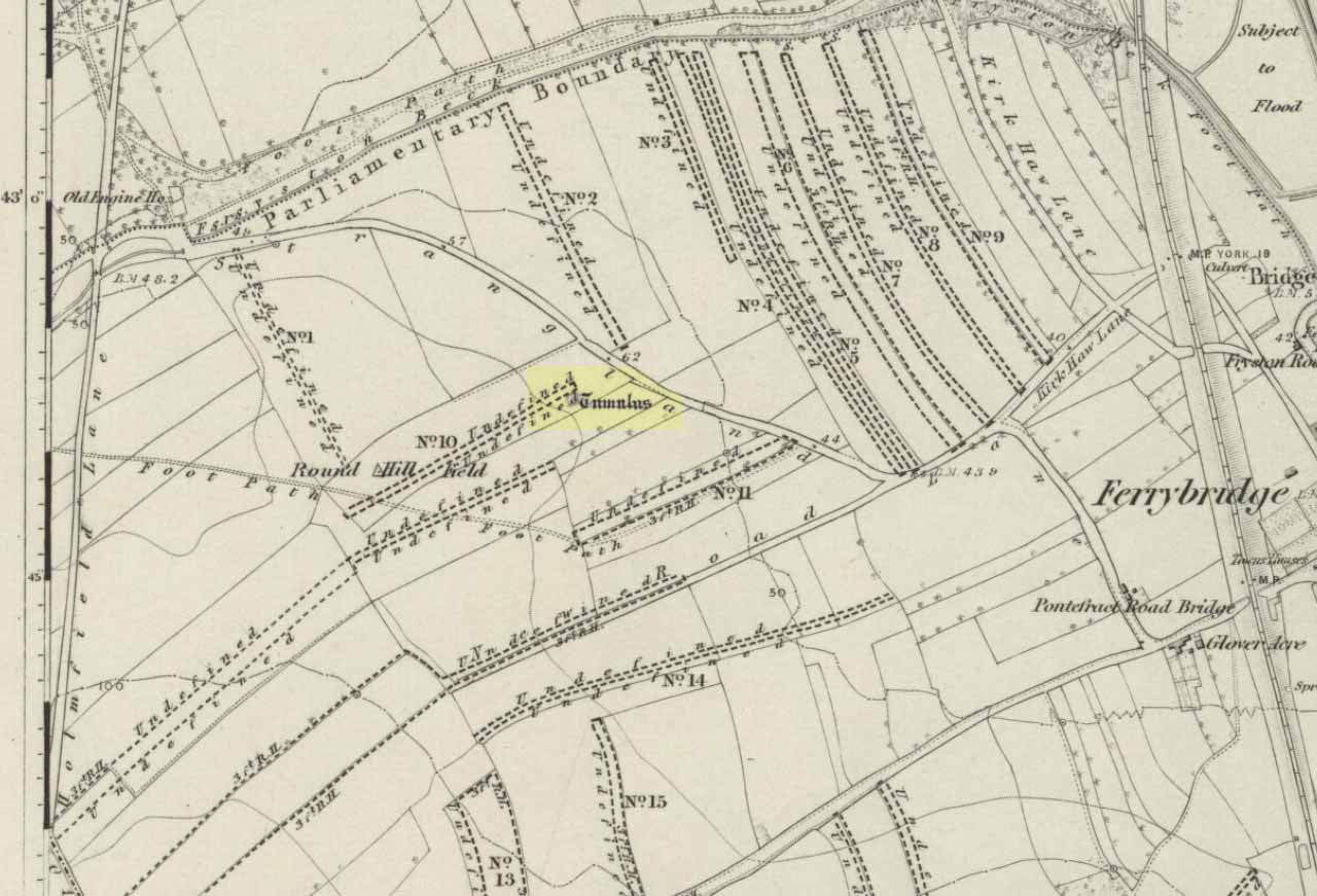
Tumulus (destroyed):  OS Grif Reference – SE 4734 2449

Also Known as:

  1. Mound 1 (Pacitto)
  2. Roundhill Field

Archaeology & History

Pacitto’s plan of the tomb (after YAJ, 1969)

One of a number of sites that used to exist in this part of West Yorkshire before the coming of the Industrialists and their ecocidal ways.  Found in conjunction with the Round Hill Field tumulus 53 yards to the south, this fallen monument was thankfully looked over several times before its final demise when the power station was built. The first literary account of it seems to be Forrest’s (1871) local history work, soon followed by another dig by the legendary tomb raider, William Greenwell. (1877)  Both of these digs were very good indeed and give us the most detailed account of the remains here.

One of the urns found in the mound (Forrest 1871)

The name of this tumulus and the nearby Round Hill site needs some clarification before continuing to the archaeological account.  In both Forrest and Greenwells’ accounts, they each named this site as the ‘Round hill tumulus’, but since their original fine work, archaeologist A.L. Pacitto (1969) and his team found the other previously unrecorded tumulus and surrounding ring-ditch in the original field called Roundhill field.  Old records showed that a wall or fence once ran between the two sites, and that the tumulus which Forrest and Greenwell previously called the Roundhill site was actually located in the curiously named ‘Angel Moon field’ — hence the change of name in this (and Pacitto’s) account. (if y’ get mi drift) It’s an important point.  So as you read the accounts below, where the authors describe the Roundhill tumulus, they are in fact referring to this, the Angel Moon tumulus.  Gorrit?  OK!

The site was noted for the first time as a tumulus by the local owner of the land here, a Mr Hall, in 1811, who wanted it levelled and attempted,

“to remove it altogether, but so many human bones were then met with, that after removing a considerable portion, it was abandoned, and the exhumed bones removed to the neighbouring churchyard of Ferryfryston.”

Mr Forrest then said:

“We are told by an eye-witness that on this occasion two plates of metal were found, but of what kind of metal pr what became of them we have no certain information.”

Thereafter began Forrest’s lengthy account of the initial excavation of the Angel Moon burial mound, undertaken (I think) by himself and other locals.  Readers will hopefully forgive the lengthy profile I’ve given this place, but I know it will be of interest to local historians in the Pontefract and Ferrybridge area:

“This Tumulus, which is situated in Roundhill Field, on the left of the road leading from Ferrybridge to Castleford was first opened on March 28th, 1863. For the sake of ascertaining its structure, a trench was dug on the side not previously disturbed, to within a few feet of the centre, but without result, except ascertaining that the material gradually changed from sandy gravel to large stones as the middle was approached, and that it had been raised upon a natural swell of the strata, thus offering a dry situation; a condition about which the ancients appear to have been solicitous in choosing the sites of their sepulchral mounds. They then began to dig at the top, and immediately under the sod lay two human skeletons, one upon the other, with no more than six or eight inches of soil upon them. Near them lay portions of two antlers of…red deer, the uppermost skeleton was that of a tall adult male, the teeth nearly entire and in fine preservation, the other was of shorter but stouter proportions, the feet of both were gone, probably by the diggers in 1811, who it is conjectured had previously discovered these remains, and covered them up, with the few inches of soil, under which we found them; they had evidently not been removed, all the bones present being in their natural position, the whole of the bones and horns were much crushed and broken by the superincumbent earth which must once have covered them.

“With them were found several detached pieces of what appeared to have been the tusk of some animal, probably the wild boar, and fragments of half-baked pottery which on comparison were found to be portions of two urns of the early British type, such as are usually found in grave-hills attributed to that period.  The smaller one (of which the principal portions were recovered) was of the size and much of the shape of an ordinary breakfast cup, three inches high, scored all over with vertical indentations as if by a piece of flint. The other was much larger, more elegant in shape, on which considerable taste was displayed in the ornamentation, composed of parallel lines, chevrons, zigzags and punctures, in which a dextrous use of the twisted thong was evident; this was ten inches high.

“About eighteen inches to the left of these, and a few inches deeper, lay the skeleton of another person, who had evidently lived to a great age, the teeth being worn nearly to the roots, tho’ showing no signs of decay. All the three lay east and west as in the present mode of Christian sepulture. No other human or animal remains were found, nothing metallic, or any implements, no appearances of cremation, no ashes, neither did the urns appear to have contained any, no stones to indicate that a cist had enclosed them, they had been buried in the soil, which here only differed from that surrounding it, in its somewhat darker colour.

“Digging downward, immediately under the skeletons first discovered, a large rough slab was reached at the depth of four feet from the surface. Its removal disclosed a stone cist or grave, of which it had formed the cover, composed of four rough stones set on edge, and paved with smaller pieces at the bottom; width at the head 2 feet, at the feet 1 foot 5 inches internal dimensions. It was entirely filled with small gravel, in which was interred the skeleton of an adult male, apparently of large stature, the thigh bones measuring in length 19¾ inches, the leg 16 inches. The knees were bent up in the manner in which such interments are usually found, and the face toward the south.  The skull was accidentally broken, but well developed, and indicating the age about forty. The teeth were all present, and in beautiful preservation, the enamel white and bright as in the living subject.  In front of the breast was an urn, laid on its side, of very coarse make, imperfectly baked, and so fragile, that on the most careful attempt to remove it, the urn crumbled into fragments, the whole was however collected, and sufficed to give a correct idea of its size, shape and ornamentation. It contained nothing but small gravel, like that in which it was laid. Near it was a small chipping of flint with a cutting edge, 2½ by 1¼ inches, this was the only article having any resemblance to a tool or implement hitherto met with.

“The cist being filled with gravel, I suppose to be an unusual circumstance.  It could not have penetrated through any fissures in its sides, neither was the cist likely to have been opened subsequently, as nothing appeared to have been disturbed.

“Proceeding downward, it was seen that this cist was built upon and its sides supported by large rough stones inclined towards it ; the surrounding gravel was mixed with fragments of human bones, small pieces of urns, and occasionally bits of charcoal, and in a cavity a piece of wood was found but so decayed that its original shape or purpose could not be ascertained. Among the bones was a portion of a skull, showing a fracture from which the subject had recovered.

“At about the depth of seven feet, and a little to the east was a flat stone laid horizontally, length 4½ feet, width 3 feet, under this was a layer of dark earth two or three inches thick, totally different from that surrounding it, inodorous, and in which was no perceptible trace of animal remains, but exhibiting hollow casts of something resembling stone fruit about 1 inch long by ½-inch wide. Near this was found a thin stone of a round or oval shape about 6 inches broad, apparently chipped to shape and having a rough cutting edge ; its use can only be conjectured.

“At the depth of nine feet, the native rock was reached in which was a cavity about ten inches deep, but as far as could be ascertained containing nothing but gravel mixed with bones like the surrounding part.

“From observations then made I came to this conclusion: that the mound had been used for interments anterior to the formation of the cist, on which occasion, its upper part was levelled to make a convenient platform for it ; when the bones of former interments were disturbed and scattered about with as little respect for the dead as would a modern gravedigger; in making room for a new occupant.

“The fact of the three skeletons first noticed being interred after the Christian mode, is presumptive evidence that they were Saxons. It is well ascertained that this people had their coming here, frequently buried their dead in British tumuli, even after they had embraced Christianity, which occasioned an edict to be published in the year 987, prohibiting this practice, and providing that no Saxon should be buried in the tumuli of the Pagans, but only in the cemeteries of the churches, neither do urns nor antlers (which are undoubtedly British) militate against this supposition, when it is considered that they were all fragmentary, and as the skeletons with which they were, had evidently been disturbed though not removed, it is very probable that these fragments had been taken from that part of the mound removed in 1811, and thrown among these bones in the random manner in which we found them.

“From all these circumstances, this barrow appears to have had a very early and prolonged existence as a place of sepulture. The cavity in the rock was probably the grave of the first interment. The fragments of bones under and around the cist show that interment had taken place before its formation. The absence of any evidence of cremation either in the cist or elsewhere, shows that these interments were prior to the introduction of that ceremony from the nations with whom the Britons afterwards had intercourse. The absence of any weapon or other instrument save the single chipping of flint, and the roughly fashioned stone and the rudely found urn of clay, all go to prove that this was one of the very earliest of British Barrows. And if my hypothesis as to Saxon burial be admissible it will bring its sepulchral history down to the Christian era.

“At the upper end of the field are some earthworks of considerable depth, but as the whole is under cultivation, their form and purpose can scarcely now be determined.”

A few years later the legendary tomb raider Mr Greenwell and his mates turned up and gave the site their additional attention.

“On this occasion the digging commenced on the east side, where a deposit of burnt bones was found upon a flat stone just above the surface, and ten feet from the outside.  Six feet to the north of this was another similar deposit laid upon the natural surface. Five feet south of the centre, was an unburnt body, doubled up and on its right side, with its head to the south. Immediately beneath, and in close contact with it, was a burnt body, apparently deposited at the same time. These interments in opposite customs present very interesting features in British sepulchral usage, as if the practice of cremation though at one period generally adopted, was not universal, but influenced by the wish of the deceased, or the inclination of surviving friends. With these remains were found an urn, of beautiful type, 4½in high, ornamented outside with twenty-seven thong markings, it would be impossible to decide to which of the bodies this belonged, such urns are found with both modes of burial.

“These deposits of burnt bodies were all found on the south-east side of the tumulus and consequently none were met with during the partial examination in 1863; but as the diggers in 1811 commenced at that point, they must have found and removed several such.

“As the work proceeded, the large flat stone covering the deposit of dark earth, was again met with ; and southward of this was another similar deposit also covered by a stone.  In this earth was found a small seed pod or fruit, with striated markings, about nine lines in length, and black as the soil in which it was found ; its size and shape suggest the idea, that such fruit might have been the occasion of the hollow cists observed in the first discovered deposit.  Close to these deposits was one of very dark sand, inclined to dark red or chocolate colour in some parts, this had evidently been subjected to the action of fire.

“The tumulus was so far removed, as to reveal the nature of the surface on which it had been built, which proved to be a natural outcrop of the limestone rock, and upon it these dark deposits were found. Their origin and purpose, offer an interesting subject of enquiry to the Archeologist. Their situation on the edge of the projecting rock is suggestive of their sacrificial character, or their connection with some of the druidical rites of the ancient Britons. The burnt sand may mark the site of the place where the act of cremation had been performed.

“The next object of interest was the rock grave, the edge of which had been reached in 1863, but reluctantly abandoned. This was found, and proved to be a large circular one, nearly six feet in diameter, and two feet six inches deep. At the west end was a rudely-formed cist, filled with gravel like the first one, in which was found a body, bent up in the usual manner, lying on its right side, and with its head to the south-west.  At its feet was a drinking cup laid on its side, height seven inches, profusely ornamented with thong markings, consisting of three sets of horizontal lines filled up between with vertical lines, below these, and between two more horizontal lines, was a line of zigzags, the lower triangles of which were filled up with horizontal markings. The same pattern occupied the upper and lower halves of the vase. In the hollow of the knees was found a bronzed pin much oxydized, about 1½in. long, this might have been used to fasten some portion of the dress in which the person had been buried. It was the only piece of metal found in the tumulus, with the exception of that found in 1811, which is now supposed to have belonged to an Anglo-Saxon, buried with sword, spear, shield, etc.”

Then in 1962 came the final examination here, shortly before the site’s destruction.  Pacitto (1969) and his team didn’t really find much more than his Victorian predecessors, apart from a couple of flints, some other fragments of bones and some modern bits and bats.  However,

“The mound was surrounded by two concentric ditches, respectively 55ft and 75ft in diameter.  The outer ditch was only a few inches deep, but the other had been cut into the limestone (my italics, PB) to a depth of 2ft 6in”

References:

  1. Forrest, C., The History and Antiquities of Knottingley, W.S. Hepworth: Knottingley 1871.
  2. Greenwell, William, British Barrows, Clarendon Press: Oxford 1877.
  3. Pacitto, A.L., “The Excavation of Two Bronze Age Burial Mounds at Ferry Fryston in the West Riding of Yorkshire,” in Yorkshire Archaeological Journal, volume 42, part 167, 1969.
  4. Roberts, I. (ed), Ferrybridge Henge: The Ritual Landscape, WYAS 2006.

© Paul Bennett, The Northern Antiquarian


Round Hill Field, Ferrybridge, West Yorkshire

Tumulus (destroyed):  OS Grid Reference – SE 4733 2444

Also Known as:

  1. Mound 2 (Pacitto)
  2. Roundhill Field

Archaeology & History

Tumulus on the 1852 map

Close to the important ceremonial monument of Ferrybridge Henge could once be seen be this singular grave and ring-ditch, 53 yards north of the curiously-named Angel Moon tumulus. But, thanks to that regular ingredient of self-righteous industrialism, neither of the sites exists anymore.  It had initially been damaged by some agricultural ignorance (they like to the PR-term ‘agricultural improvement’), but was thankfully rediscovered following excavation work on the Angel Moon site by A.L. Pacitto in April 1962, in advance of the construction of the Ferrybridge C power station. (in truth, the exact position of this Round Hill tumulus was in an area that has not been built onto, at the southeastern edge of the modern car-park on the grassy area next to the trees; showing that it could have easily been preserved).

Roundhill tomb skeleton
Roundhill tomb plan

The site was certainly an important one amidst what Ian Roberts (2006) called “the ritual landscape” in this part of prehistoric Airedale.  When the archaeological team came to do their work here, very little of the monument could be seen on the surface—Mr Pacitto described it as “barely perceptible”—but they were both pleased and surprised at what they found.  Detailing their excavation work, Pacitto (1969) wrote:

“Natural rock was found immediately below the ploughsoil, and it had been scored by ploughing.  In view of the complete lack of stratification the first traverse of the (Drott) machine was arranged so that it cut across the mound from side to side, with one edge coinciding with a line drawn through the centre.  This first traverse exposed half an oval grave pit, measuring 3ft 9in by 5ft.  On excavation it proved to be only 5in deep, but in spite of this it contained an undisturbed crouched inhumation.  The body was on its left side, facing south, and a notched flint dagger behind the pelvis was perhaps attached to a belt at the time of burial.  The dagger…is very neatly flaked from a fine flint with a pale blue patina.  It has three notches on each side of the haft and is very similar to one found in Doncaster in 1935.  The filling of the grave also included several fragments of human bone, one of which had been calcined.

“The grave was surrounded at a distance of 11ft to 12ft by the remains of a circular ditch.  Only two segments of this had survived, representing less than half of the total circumference.  Doubtless ploughing had destroyed much of the original rock surface.

“Outside the ditch and 20ft to the southeast of the grave was a small circular pit.  With a flt bottom and vertical sides, it measured 2ft 3in in diameter and was 1ft 2in deep.  The filling was mainly of broken and crushed limestone fragments, and there was no clue to its date or purpose.  This pit was sited on the line of an east-west fault or joint in the rock.”

References:

  1. Forrest, C., The History and Antiquities of Knottingley, W.S. Hepworth: Knottingley 1871.
  2. Pacitto, A.L., “The Excavation of Two Bronze Age Burial Mounds at Ferry Fryston in the West Riding of Yorkshire,” in Yorkshire Archaeological Journal, volume 42, part 167, 1969.
  3. Roberts, I. (ed), Ferrybridge Henge: The Ritual Landscape, WYAS 2006.

ACKNOWLEDGEMENTS:  Huge thanks to the Yorkshire Archaeological Society for use of images in this site profile.

© Paul Bennett, The Northern Antiquarian


Elphillock, Kildrummy, Aberdeenshire

Cairn:  OS Grid Reference – NJ 4907 1274

Also Known as:

  1. Elf Hillock

  2. Elphhillock

Archaeology & History

There is some confusion as to whether this mound of earth, barely four feet high but some 50 feet across, is actually prehistoric.  But the folklore has that common ring to it, found at olde sites from Cornwall to northern Scotland, speaking of old tombs and ancient ways…

Folklore

In modern times apparently, earthlights have been reported flitting about around this earthen ridge, but the old mound has older, more familiar tales spoken of it.  In Rev. Williams’ (1901) article on the folklore of Stirlingshire, he made a considerable detour to tell of some old faerie-lore he’d heard when he was younger, from the prehistoric tomb on the northern side of Elphillock, a few miles south of Kildrummy.  In talking with some of the local people about old beliefs, one local man told him:

“The fairies of my native parish made their abode in a round knoll, known as Elfhillock.  My friend, James Smith, now no more, was ploughman at Cairncoullie, in the neighbourhood.  Passing the hillock one evening, he heard the sound of music and dancing.  James drew near to the spot and saw the revels.  He waited and enjoyed himself for a short space and then returned to Cairncoullie and went to bed.  He found to his amazement that he had been away a year and a day!  Every field on the farm and the new ploughmen bore evidence to the fact; and Jamie believed till his dying day that he was a year older than he was aware of, and all because he had given heed to matters he had no business with.”

Not only were the little people said to live within this small tomb, but the hillock must also be cared for and never damaged.  Rev. Williams also narrated that the grandfather of the same local man told him that he had,

“pulled some heather from this elf hillock.  He was compelled by the women to replace it, otherwise he would have to encounter the wrath of the fairies.”

Thankfully the old hillock is still here, just off the roadside.  Not far from here are a number of other prehistoric sites with faerie and ghost-lore and mythological place-names, long since fallen into memories old…soon to be lost perhaps…

References:

  1. Williams, George, “Local Superstitions,” in Transactions of the Stirling Natural History and Archaeological Society, 1901.

© Paul Bennett, The Northern Antiquarian


Duel Cross Hill, Grafton, North Yorkshire

Tumulus (destroyed):  OS Grid Reference – SE 426 634

Also Known as:

  1. Deuill Cross Hill
  2. Devil’s Cross
Urn from Devil’s Cross tumulus

Archaeology & History

In Henry Smith’s wonderful Reliquiae (1852) on the history of Aldborough and district, this intriguingly named but forgotten site is given the greatest literary attention extant.  Assumed by a couple of modern academics – without evidence – to have been little more than a natural hillock, this once great mound was undoubtedly an important burial place for some ancestral characters.  Although its exact location is unknown (anyone out there know for certain?), it was said to have been located about 100 yards from where the old tracks crossed at Duel Cross.

First described by a Mr Urban in the Gentleman’s Magazine of June, 1787.  He told it to be known as the Devil’s Cross and was a tumulus,

“whose elevation is about 18 feet, and circumference at the base 370 feet.  It was broken into some time since to supply materials for the repair of the high road leading from Aldborough to York. The soil consists, first, of a black earth, and under that a red sandy gravel, human bones, some of which are entire, and urns of various sizes.  The urns are composed of blue clay and sand, some ornamented and others quite plain; several Roman coins have also been found here.”

There were a great number of old urns found in the mound when it was dug into in 1756, leading Mr Urban to believe the site was used an ancient cemetery.  Intriguingly he told that all of the urns and their ashes were found to have been placed on one side of the mound, with many human bones being deposited in another section, away from the urns.  This, the finding of Roman coins next to the mound and the proximity of the Roman road led Mr Urban to believe the site was a Roman tumulus, though this seems unlikely.  Years later, Henry Smith’s (1852) commentary on the Devil’s Cross hill led him to believe the mound was from a much earlier period:

“From a sketch of one of these, which is stated to have been nine inches high, there can be little doubt of these cinerary urns bring of the ancient British period, but from the great number of bones discovered, this tumulus was probably used as a cemetery during the Romano-British period, if not still later.  Of its use in Roman times, evidence is unequivocally supplied in the numerous coins found here…”

Carved stone figure (from Smith’s ‘Reliquiae’)

Not far from this long lost tumulus,  a curious carved stone figure was located “among ancient foundations” in a cellar!  Thought to be a local deity, it may have been a carved representation of whichever figure or spirit ancestor was buried in Duel Cross Hill — though we’ll never know for sure.

Folklore

Although archaeologically, etymologically and geomantically related to the nearby Devil’s Arrows at Boroughbridge a couple of miles up the road, there is nothing specific I can find of this once important tumulus.  However the place-name in both forms, Deul and Deuill, refers to the pre-christian devil (from deofol, Old English, “devil”).  This name may relate to the stone figure shown in the illustration, or of long lost heathen rites enacted here in bygone times.  Any further info on this place is very welcome.

References:

  1. Hargrove, E., The History of the Castle, Town and Forest of Knaresbrough, Hargrove & Sons: Knaresbrough 1809.
  2. Smith, Henry E., Reliquiae Isurianae, J.R. Smith: London 1852.

© Paul Bennett, The Northern Antiquarian


Intake Lodge, Yearsley, North Yorkshire

‘Tumulus’ (destroyed):  OS Grid Reference – SE 592 737

Archaeology & History

Bronze Age pottery (after YAJ 1963)

A curious entry inasmuch as it’s difficult to categorize the site correctly.  Added to this is the fact that the place has been built over!  But despite these misgivings (if that’s the right word!), the site’s deserving of a posthumous entry…

There used to be a curious-looking mound here, immediately east of Intake Lodge, that “was due to be bulldozed so that a field of rough pasture could be brought under cultivation”, killing the indigenous wildlife that was living here.  However, before this was done, some inspectorate dood who worked for the Ancient Monuments Commission and the Ministry of Works “decided to excavate”, as he believed that an ancient burial mound was in the field.  Mr I.M. Stead (1963) takes up the story, telling:

“”This mound was about 75ft by 90ft diameter and 6ft high, on ground sloping away to the south-east.  It had every appearance of being a barrow.

“The excavation, in October 1961, was supervised by the writer (and) assisted by Mr A.L. Pacitto.  A trench on the east side revealed layers of sand which appeared to be natural, and a second trench, on the west side, uncovered a capping of stone which confirmed that this was not a barrow.  However, it seems that the writer was not the first person to mistake it for an artificial burial mound.  A disturbed area in the centre, some 15ft diameter, where there had been an old water-tank, produced a fragment of Bronze Age pottery and a sherd from another Bronze Age vessel was found in a disturbance on the side of the mound.  A small area near the centre was cleared in the hope of finding an undisturbed burial, but shortage of funds did not permit more extensive stripping.  Judging from the type of pottery (see image) and its situation on the mound, there can be little doubt that one two occasions Bronze Age people placed secondary burials in the natural mound.”

This tells us that although the mound wasn’t a tomb or burial mound in a traditional religious sense, it was instead a sacred hill of the dead for the local people at one time or another in ancient days.   And, if Mr Stead had been a decent archaeologist and continued to excavate here without pay (as he should do if he loves his subject), we may have found more beneath this now-lost sacred mound.  Unfortunately this didn’t happen and we lost vital clues and information.

References:

  1. Stead, I.M., “An Excavation at Yearsley, North Riding, 1961,” in Yorkshire Archaeological Journal, part 161 (volume 41), 1963.

© Paul Bennett, The Northern Antiquarian


Elf Howe, Folkton, East Yorkshire

Tumulus (destroyed):  OS Grid Reference – TA 0422 7726

Archaeology & History

A once-impressive haunted burial mound on the southern edge of Folkton parish, all that remains of the place now are aerial images showing the ghostly ring of its former site.  Commenting on the destruction of this burial mound  before he had chance to give it his full attention, in William Greenwell’s (1877) magnum opus he wrote the following:

“Elf Howe had been removed to a great extent, and the grave had been dug out before I had an opportunity of examining it.  I however got an account of what was discovered from the foreman on the farm, and I was able personally to inspect a small portion which had not been disturbed.  The barrow had been 60ft in diameter and 6ft high, and was made of earth and chalk.  Near the centre a deposit of burnt bones was met with, over which some large flints were placed; this was at a depth of 4ft, and as a great quantity of burnt earth was observed immediately round the bones, it is probable that the body had been burnt on the spot where the bones were placed.  Two unburnt bodies were found on the south side of the mound, with one of which a vessel of pottery was associated.  At a distance of 17ft south-south-east of the centre I found the body of a strongly-made man, laid on the right side, with the head to the south and the hands to the knees; he body was placed about 6in above the natural surface.  Immediately below the head was the body of a very young child, the bones of which were too much decayed to admit of anything being made out beyond the fact that it was a child’s body which was laid there.  Still lower, and on the natural surface, was a patella, a radius, and some other bones of a body, which had been disturbed, probably in the interring of the person who was found buried above.  At the centre was a grave, lying northwest and southeast, 7ft by 6½ft and 2½ft deep.  On the bottom at the north side was the body of a strongly-made man in the middle period of life, whose head…was to the south, but my informant could not remember on which side the body was laid; at the head was a ‘food vessel’, which, from the fragments that have been preserved, must have been a rudely-made one with unusually thick walls.”

Folklore

Although antiquarians and archaeologists such as Elgee, Grinsell, Gutch, Johnson and others each tell (in their own respective ways) that Elf Howe “testifies to a widespread belief in goblin-haunted barrows” — albeit in the linguistic ‘elven’ of the Scandinavian invaders — we appear to have lost the original tale behind this fairy-haunted site.

References:

  1. Greenwell, William, British Barrows, Clarendon Press: Oxford 1877.

© Paul Bennett, The Northern Antiquarian


High Marchup, Silsden, West Yorkshire

Tumulus:  OS Grid Reference – SE 0501 4949

Also Known as:

  1. Parson’s Lane Tumulus

Getting Here

High Marchup tumulus

From Silsden go up the long hill (A6034) towards Addingham until the hill levels out, then turn left on Cringles Lane (keep your eyes peeled!) for about 500 yards until you reach the Millenium Way footpath, or rather, green lane track, to your right.  Walk along this usually boggy old road for another 400 yards until you’re level with the small copse of trees below the field (about 100 yards away).  The slightly raised ditched mound on the left side of the track ahead of you is what you’re after!

Archaeology & History

Unless this old tomb was pointed out, you probably wouldn’t give the place a second glance.  It’s a seemingly isolated singular round tomb, subsided on top and surrounded by a small ditch, running into the edge of the walling.  Gorse bushes and a few rocks are around the edges of the site.  Harry Speight (1900) described this old tomb as a

“lonely isolated mound, to be seen in Parson Lane about a hundred yards west of the Celtic boundary, Black Beck, where some old dying chief has called his friends around him bidding them, “heap the stones of his renown that they may speak to other years.”  It is a tumulus 80 feet in circumference and does not seem to have been disturbed.”

In Faull and Moorhouse’s (1981) magnum opus they describe the site as “the denuded remains of a ditched round barrow,” but say little else.  It may have had some relationship with the settlement remains in and around the huge Counter Hill complex, immediately north.

References:

  1. Cowling, E.T., Rombald’s Way: A Prehistory of Mid-Wharfedale, William Walker: Otley 1946.
  2. Faull, M.L. & Moorhouse, S.A. (eds.), West Yorkshire: An Archaeological Guide to AD 1500 (4 volumes), WYMCC: Wakefield 1981.
  3. Speight, Harry, Upper Wharfedale, Elliott Stock: London 1900.

© Paul Bennett, The Northern Antiquarian


Werneth Low, Hyde, Lancashire

Settlement (destroyed):  OS Grid Reference – SJ 959 928

Archaeology & History

Known by this name – Werneth – since at least the 12th century, place-name masters Ekwall, Smith and others have tended to think the place derives from a hypothetical British word, *verno-, meaning alder trees – though I aint so sure misself.

It’s been difficult to ascertain the precise nature of this prehistoric arena. Many mesolithic flint finds and old stone axes have been found around the area, but it seems primarily to have developed into a neolithic and Bronze Age settlement and burial site. A number of cairns were once here, and both rounded and linear earthwork features occur in the area; but there’s been considerable disturbance in and around the site and without in-depth archaeo-surveillance, much remains hidden.

References:

  1. Abraham, John Harris, Hidden Prehistory around the North West, Kindle 2012.
  2. Ekwall, E., The Place-Names of Lancashire, Manchester University Press 1922.
  3. Marriott, W., The Antiquities of Lyme and its Vicinity, Stockport 1810.
  4. Nevell, Michael, Tameside before 1066, TMBC 1992.

© Paul Bennett, The Northern Antiquarian