Bittova trek this one. Once on Colonsay, head out onto the B8086 road west of Scalasaig until you, past Machrins, and onto the gold course. Take the footpath across it (south), until you hit the little airstrip where you need to veer right (west) right onto the spur of the coast about 800 yards away. Your damn close!
Archaeology & History
Highlighted on the 1878 OS-map of the region, this site occupies a prominent position. Its summit is surrounded by a line of oval walling enclosing an area of about 90 square yards. There are also remains of of outer walling to the eastern and southern sides. The ‘cairn’ on the highest spot in the middle of the hillfort is a modern construction.
Folklore
The great Scottish folklorist A.A. MacGregor (1947) narrated the tale behind this denuded fort on the western edge of the island. According to the islanders who told him the tale, they alleged it Norwegian in origin, though the fortress is much older than that. MacGregor told that, “in this fort there once lived an elderly and voluptuous tyrant named Grey Somerled, who is said to have been related to the first of the Lords of the Isles.
“Grey Somerled came to Colonsay, they say, in the capacity of factor. But he neglected his duties, imposed penalties and hardships on the innocent and defenceless tenants, and generally made himself so disagreeable that at last it was decided to take revenge upon him, previous warnings having been no deterrent.
“Like Rory Mor of Dunvegan, who slept best when he was within hearing of his ‘nurse’, the waterfall, Grey Somerled was wont to be lulled to sleep by the grinding noise of a quern placed near his head. When he retired for the night, one of the servants had to turn the quern-stone by his pillow, and keep on turning it, lest he woke.
“It was recognised that any attempt to surprise Grey Somerled during daylight was foredoomed to failure. So, a plot was laid to circumvent him during the night-time. His enemies entered into a conspiracy with one of the servants that she should allow them to invade Dun Gallain after he had fallen asleep. When they arrived, one of their number relieved the woman at the quern, and proceeded to turn the stone without intermission. But he was not too skillful at the turning; and his harsh and irregular grinding soon woke the sleeper. Ere Gey Somerled had had time to consider the matter of resistance, his foes were upon him. They carried him away from Dun Gallain; and tradition in the islands of Argyll has it that, in great privation, he spent the remainder of his days in a bee-hive house of stone, situated on the farmlands of Machrins.
“One night – so the story concludes – a huge boulder from the roof of the bee-hive fell in, killing its unhappy inmate. So as to identify the spot where this tragedy happened, the islanders raised on it the cairn now indicated on the Ordnance Survey Map as Carn Shomhairle Liath – that is to say, Grey Somerled’s Cairn.”
Interestingly, there is a long-cist burial at Machrins (plus small settlement) a few hundred yards east of the fort, and excavations here found them to date from the Viking period; though the Scottish Royal Commission thought that although the “small finds associated with the burial suggest that it is Viking, the plan-form of the houses is perhaps more likely to indicate a native tradition.”
References:
MacGregor, Alasdair Alpin, The Peat-Fire Flame, Ettrick Press: Edinburgh 1947.
Royal Commission of Ancient & Historical Monuments, Scotland, Argyll – volume 5, HMSO: Edinburgh 1984.
Go up the A93 road from Blairgowrie, after 5 miles turn right at the Bridge of Cally and up Glen Shee. After another 3½ miles, keep your eyes peeled for the iny road on the right signposted to the Drumturk Cheese farmshop. Go up this long tiny winding road, a mile up past the cheese place (which are gorgeous btw!) and onto the open moors. Keep on this road for another 2¼ miles where you can park up near the entrance to the huge wind-farm. Walk up the track to the windmills, bearing right at the first junction, then right again at the next one. From here, walk to the second windmill and from its base walk down, east, into the heather for about 80 yards. You’re damn close!
Archaeology & History
Drumderg (3) carving
On this T-square-shaped earthfast stone, a hundred-and-twenty yards north of the impressive Drumberg (2) petroglyph and just 10 yards below the remains of an impressive hut circle, we find this somewhat plain cup-marked design. It was covered pretty deeply beneath the heather when we came here and it took some time before we could see what we were looking at. The grey skies and poor daylight didn’t help matters either, as the cups were difficult to make out at first, but, thankfully, you can just about see them in the photos.
There are between five and seven shallow but distinct cup-markings on the flat surface, one of which may have a faint ring around it. In truth, this carving’s only gonna be for the real geeks amongst you.
An old stone-lined burial cist could once be seen in this locale: reported in 1953 to have been “discovered in the southwest corner of a field south of Druimyeonbeg farmhouse.” When it was uncovered by the farmer, the covering capstone was missing. Any relics that may have been there were destroyed and there’s now no trace of anything.
References:
Royal Commission on the Ancient & Historical Monuments of Scotland, Argyll – Volume 1: Kintyre, Glasgow 1971.
Described in 1926 by local antiquarian and early ley-hunter, W.A. (1926), as “a fallen monolith” — this old stone is probably just a glacial erratic. Found in the churchyard of St. Mary’s, tradition tells that in ages past young girls danced twelve times around this old stone, then placed their ears upon it to hear the answers to their questions and wishes. A similar legend tells how children danced around the stone seven times on a certain day of the year to conjure up the devil. Mr Dutt thought the great rock may have been “a ley or direction stone.”
References:
Dutt, W.A., The Ancient Mark-Stones of East Anglia, Flood & Sons: Lowestoft 1926.
Pretty easy to get to. Best thing to do really, is ask a local and they’ll send you in the right direction. From Bingley, take the Harden road (B6429) across the river. As it bends sharply left, note there’s a track going up into the woods to the right. Walk up it! Keep going and, unless you take a detour, you’ll end up at the rock outcrop eventually (where the woods come to an end, Druid’s Altar appears before you with the track running along its top-side).
Archaeology & History
Mentioned in the Tithe Awards of 1849, this lovely outcrop of rocks looking down the Aire Valley on the southern edge of Bingley has “an immemorial tradition” of druidic worship, said Harry Speight in 1898 – though quite when it first acquired such repute is outside of any literary record. In Sidney Greenbank’s (1929) rare book on this place, he could find little by way of archaeological data to affirm the old tradition, save the odd prehistoric find of flints here and there; though it is said that Beltane fires were burned upon the crags here in bygone centuries.
1894 photo of Druid’s Altar (courtesy Clive Hardy)
There was a 19th century account from the Ilkley Scientific Club where a member described there being a cup-and-ring carving “near the so-called Druid’s Altar, at Bingley,” but I’m unaware of the whereabouts of this carving and Boughey & Vickerman’s (2003) said nothing about it in their survey; though a possible cup-marking can be seen on one rock less than 100 yards west, which might account for the report. (a bit dodgy though!)
Folklore
Harry Speight (1898) makes what sounds like a rare flight of fancy when he described faerie being seen atop of the many oaks beneath the Druid’s Altar. In Clive Hardy’s (2002) work (from whence the old photo of the Altar is taken), he tells how “local antiquarians say that the cobbled way running from the Brown Cow Inn towards the site, is an old processional route walked by the druids.”
One, possibly two wells, each beneath the Altar rocks, are also reputed to have been associated with the old pagan priests, as their names tell: the Altar Well and the Druid’s Well – though the Altar Well has seemingly fallen back to Earth in recent years.
References:
Greenbank, Sidney, The Druid’s Altar, Bingley, R.G. Preston: Bingley 1929.
Hardy, Clive, Around Bradford, Frith Book Ltd: Salisbury 2002.
From the north-end of Loch Tay at Kenmore, follow the road (A827) round down the lochside, through the village of Fearnan and then another 4 miles down. If you park up at the pub at Lawers, walk back up the road for ½-mile, keeping your eyes peeled up the slope on the left where you’ll see the circle visible from the road.
Archaeology & History
Much has been said of this fine old place – also known as Lawer’s Mill – which seems to have been first described by Thomas Pennant in his rambling Tour in Scotland (1772). The local writer William A. Gillies (1938) told that after
“a recent examination of the ground around the circle…suggests that at one time there was an outer circle of stones concentric with the existing one. Most of the stones were removed in order to make more of the field available for cultivation, but there are still large stones buried within a few inches of the surface.”
Folklore
In J. McDiarmid’s Folklore of Breadalbane (1910) he tells of a man from Killin who, on passing by this old circle, heard haunting fairy music. Being inquisitive, he walked up to see what was going on and walked into the circle where the little people were playing. He was obviously lucky and the faerie-folk enjoyed his company, for when he left he was given the gift of a strong, fast, white steed.
Solar folklore may be…?
References:
Gillies, William A., In Famed Breadalbane, Munro Press: Perth 1938.
This minor cursus monument was etched into the landscape in neolithic times. Found to the south of Abingdon and close to the River Thames, one report showed finds from the site dating from 2900 BC. There is also a neolithic henge monument very close to its northern terminus and a plethora of other Bronze Age remains all round. Paul Devereux (1989) described how crop marks revealed,
“a substantial former cursus immediately to the east of Drayton: its crop marks extend southwest to northeast for a little over a mile, and are 225 feet (68 metres) wide. The cursus has a squared south end, but the northern terminus has not been found. The crop marks are not evident in the middle portion of the cursus, as it was formerly overlaid by a Saxon village. There is a plethora of other crop marks within and around the cursus… The northern section…which has a slightly different orientation to the southern segment, points squarely to the ancient heart of Abingdon.”
References:
Ainslie, R. & Wallis, J., ‘Excavations on the Cursus at Drayton, Oxon’, in Oxoniensis 52, 1987.
Barclay, A., Lambrick, G., Moore, J. & Robinson, M., Lines in the Landscape, OAU: Oxford 2003.
Loveday, Roy, Inscribed Across the Landscape, Tempus: Stroud 2006.
Pennick, Nigel & Devereux, Paul, Lines on the Landscape, Hale: London 1989.
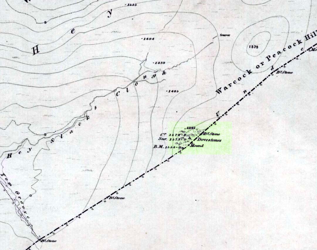
Takes a bitta finding and aint too accessible for those of you who need footpaths! Below the eastern slopes of Addlebrough Hill, by the present source of the Gill Beck right beneath the Dove Stones (the water tastes gorgeous), are the ruinous remains of an old sheepfold. In the field immediately behind (south) of here are a number of small rocks. Look around and you’ll find the stone in question!
Archaeology & History
Unless you’re a real rock-art-freak, I can’t imagine too many of you checking this one out! When Richard Stroud and I visited this spot a few years back (2006), it was a mixture of love and madness that brought us here!
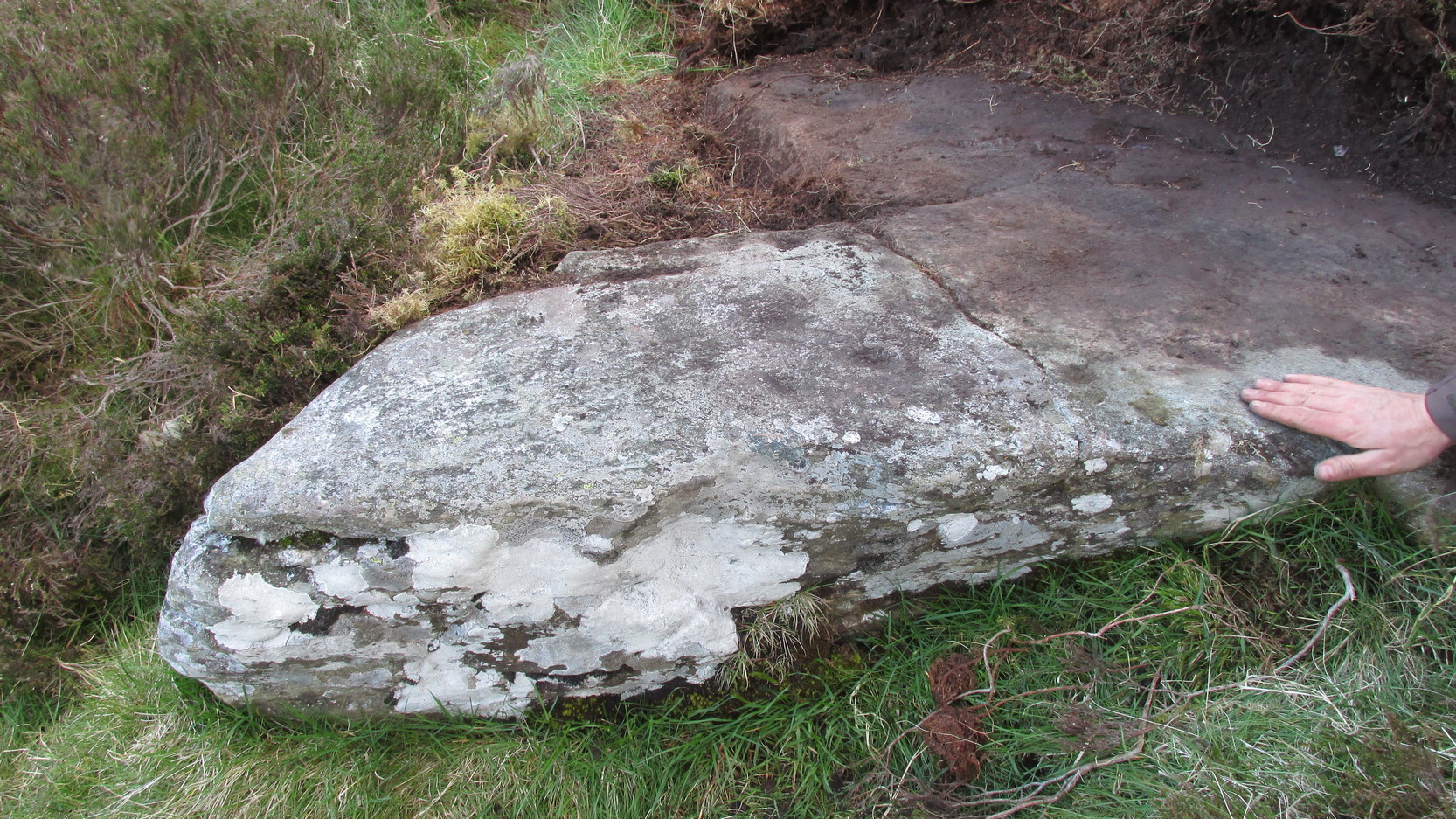
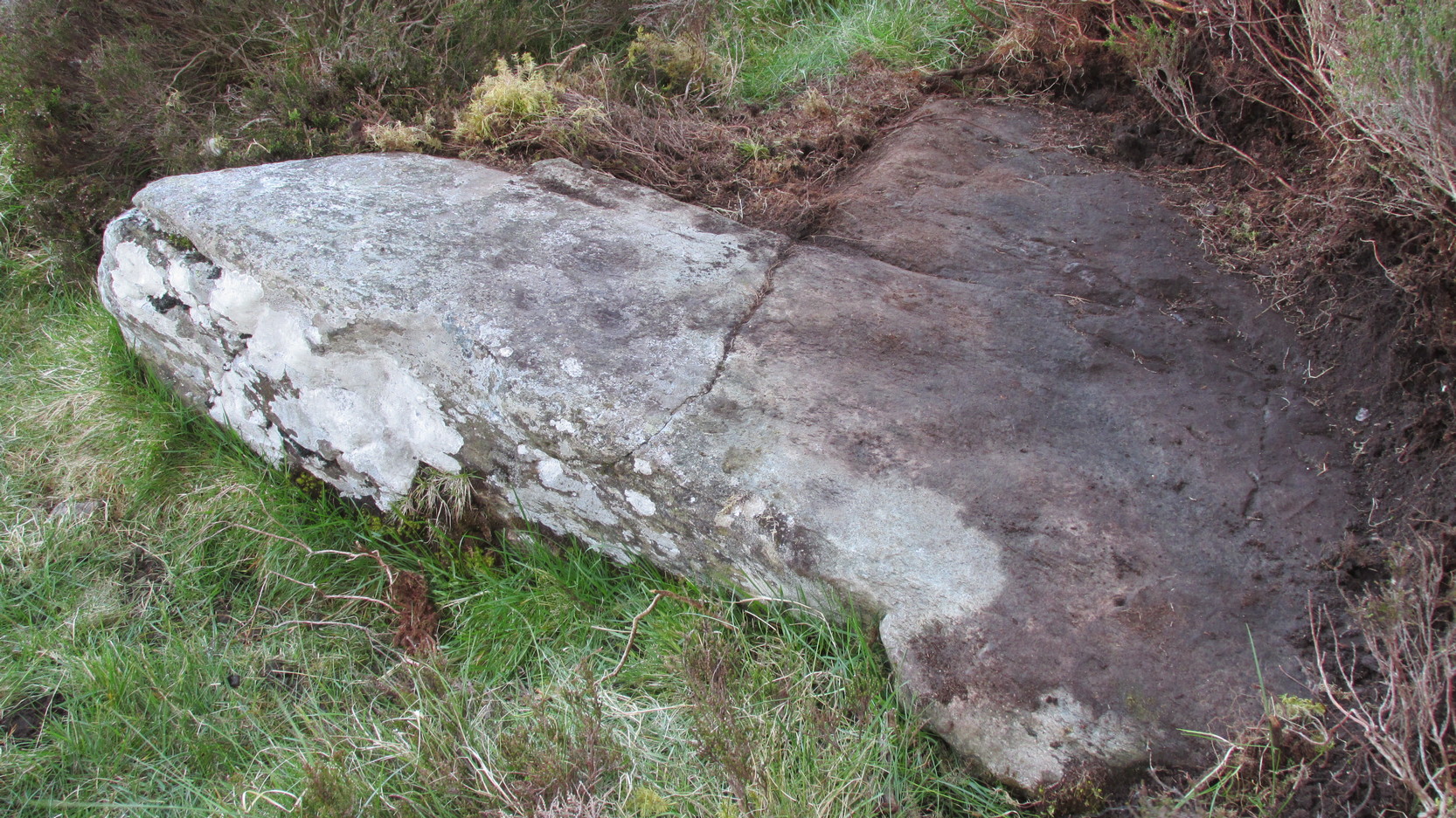
Dove Stones Carving
Amidst the many stones scattered hereabouts, one of them possesses two clear cup-marks on a stone measuring roughly 3ft by 2ft, along the line of a much ruined ancient wall. This might be the one that Beckensall and Laurie (1998) described in their Prehistoric Rock Art of County Durham, Swaledale and Wensleydale, as “a rock with several cups (which) has recently been noticed on Thornton Rust Moor, near the Dovestones” — though it seemed blatantly apparent to us that there were only two cups here, not “several”. However, Brown (2008) appears to list the site, citing it as having “two cups”, just like the one we found, and being “found in prehistoric low field settlement wall,” which fits the picture perfectly — although Brown gives a slight difference in grid-reference to the one Richard Stroud took. It looks a good area to scout around and, I reckon, find previously unrecorded sites.
References:
Beckensall, Stan & Laurie, T., The Prehistoric Rock Art of County Durham, Swaledale and Wensleydale, County Durham Books 1998.
Brown, Paul & Barbara, Prehistoric Rock Art in the Northern Dales, Tempus: Stroud 2008.
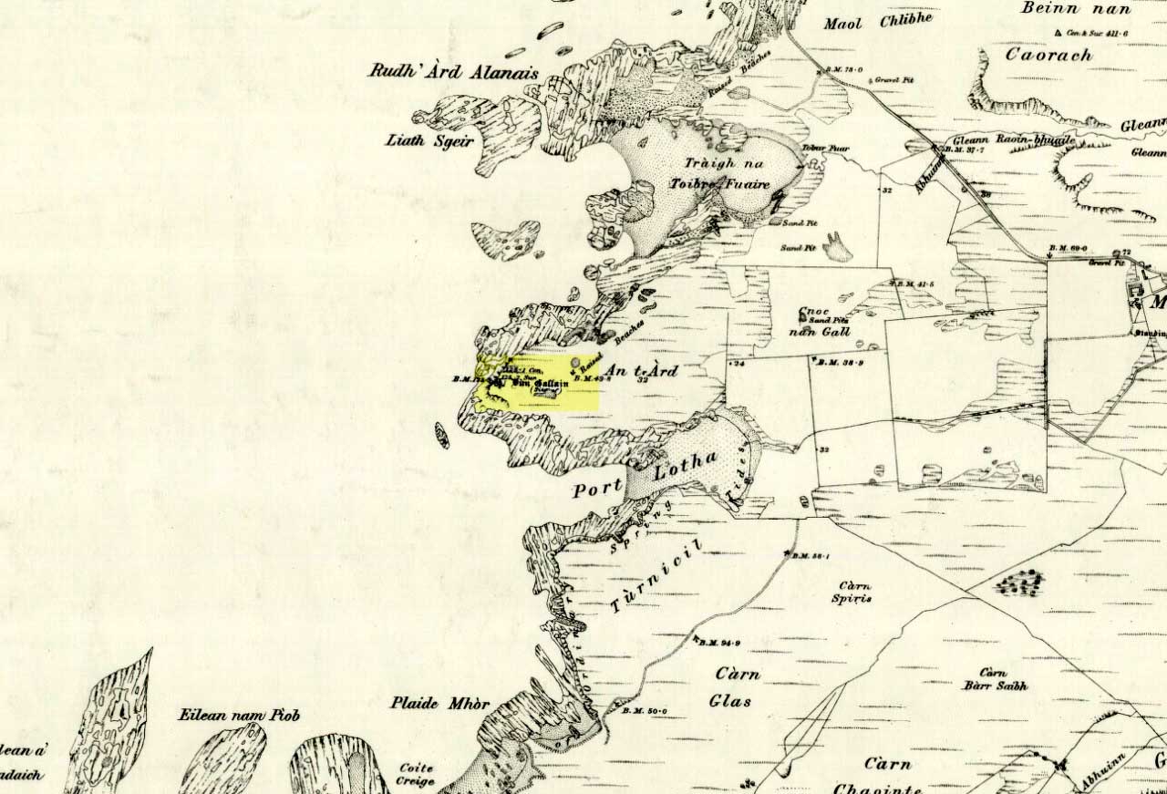
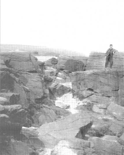
Get to Widdop reservoir in the hills west of Hebden Bridge and park up. The great rock faces to your right (north) is where you’re going. Clamber to the top until the moor levels out, making sure you head NNW for less than a mile. The moors you’re now on are supposed to be private – but folk like me pay no attention! There are no footpaths to this great outcrop, only the heathlands and scattered stones – but keep walking for a half-mile north and you’ll get to them!
Archaeology & History
Erroneously ascribed by the place-name masters Eilert Ekwall and A.H. Smith (1961) as being ‘a place where doves gathered,’ this gigantic rock outcrop on the Yorkshire-Lancashire border — as shown on early maps — is actually the Dew or Black Stones (from the Gaelic, dubh). It’s an awesome place! Takes a bitta getting to, but it’s well worth the venture.
Dove Stones on 1848 map
This long geological ridge, rising higher as you walk along it to the north, has the occasional cup-mark on it, with the giant Dove Stone at the very end having a cup-and-half-ring on its crown (be careful not to fall off). From here, you look across a huge, desolate, U-shaped valley, the far side of which we rise to 1700 feet and the grand setting of the Lad Law.
Folklore
The folklorists Harland and Wilkinson (1882) included this in their survey of druidical sites, mentioning the several cup-markings, or druid basins as they called them. (though most of ’em on here are Nature’s handiwork)
For me, this is an incredible place – full of raw power and magick. It has a curious geomantic relationship with the Whinberry Stones, a couple of miles to the south, around which should be a ring of stones…though none can be found.
Nowadays marked on modern Ordnance Survey maps as part of a ‘Neolithic Sacred Complex,’ this linear monument was part and parcel of the Dorchester Big Rings henge complex and was associated with a number of other important prehistoric sites, many of which have been destroyed by ecological disfigurement projects in recent years. In Gordon Copley’s (1958) description of the monument, not long after its initial discovery, he said that this “was a cursus which consists of parallel ditches some 4000 feet long with 210 feet between them.” In more recent times Paul Devereux (1989) described how the cursus here,
“ran for three-quarters of a mile (1.2km) in a northwest to southeast direction on the north side of the Thames and was 210 feet (64 metres) wide. The cursus was part of a complex of crop marks, the most notable being” the henge. “The northwest end of the cursus remains unknown; the southeast end was rounded. The southeast segment…was on a slightly skew alignment compared to the rest of the feature, though it may have been the earliest part of the monument – bones found there were radio-carbon dated to around 3000 BC. The southern ditch of the cursus ran through and connected two earlier sites which shared a different alignment. Deposits of cremated bones, a stone arrowhead, fragments of pottery, a polished flint axe, and a circle of pits, probably the remains of a ‘woodhenge’ structure, were all found with the cursus.”
Dorchester cursus plan 1985
Jean Cook (1985) told that later excavations on the site in 1981, found that the shallow ditch which surrounded the entire cursus, “was interrupted by a central entrance on the southeast side. The southeastern terminal ditch respected a small prehistoric monument which has been dated to approximately 2000 BC.” This and other factors has led to the thought that the cursus may not all have been built at the same time. And indeed excavations at other sites scattering the northwestern ends of the cursus (shown in the plan here, Ed.) proved that a D-shaped enclosure “pre-dates the rest of the structure.” Other mortuary sites scattered the edges of the cursus that were added in the centuries which followed, but which need excavation work to uncover their secrets. Although much of this was done in the Atkinson digs, they were summarised well by Jean Cook (1985), who told:
“Site VIII, excavated in 1948, was a monument known as a mortuary enclosure. Sometimes such structures take the form of long barrows, but this one was a rectangular enclosure bounded on all four sides by a ditch with an internal bank. There were narrow entrance gaps on the two longer sides and a wider entrance in the centre of the shorter southern side. It is dated by the substantial sherds of Ebbsfleet ware (pottery) which were found in the upper filling of the ditch; part of a human jaw from within the enclosure helps to confirm the mortuary function.
“Site XI, excavated in 1949, consisted of three or more concentric ditches, of different dates, enclosing an incomplete ring of 14 pits. The middle ditch seems to have surrounded an oval barrow or enclosure and to have then been converted to a circular plan. Some of the pits contained animal bones, one contained an antler pick and one contained a complete human cremation, but there were no accompanying grave goods.
“Both these sites were in existence before the cursus was built. (my italics, Ed.) This is shown by the fact that the southernmost ditch of the cursus cuts through Site VIII and abuts Site XI. These two earlier sites seem to share the same alignment, but once the cursus was constructed it set a new alignment which may have been of significance until the end of the 3rd millenium BC. Three monuments built after the construction of the cursus were located inside it, two of them being along the central axis, and two others were just outside the southernmost ditch of the cursus but shared the same general alignment.
“Sites IV, V and VI, which were also excavated in 1949, have a similar overall plan and all of them contained a number of cremation deposits suggesting that amongst other things they acted as cemeteries. All three sites had a circular plan and consisted of an outer bank, to define the central area, and an inner ditch, the purpose of which seems to have been to provide earth for the bank. In Site IV the ditch was made up of eight oval pits, enclosing an area of about six metres in diameter. There was a broad entrance gap on the southeast side. Inside the enclosed area there were 25 deposits of cremated bones. An arrowhead was found with one of the cremations. Site V was very similar in construction, except that the entrance gap was on the northwestern side and contained 21 cremation deposits. No grave goods were found. Site VI again had a similar plan with the entrance gap to the north. There were 49 cremation deposits , one accompanied by a flint fabricator, an arrowhead and burnt flint flakes.
“Site 1 was excavated in 1946 and consisted of a small square ditch, enclosing another more or les circular ditch with an internal bank. Inside this ditch were 13 holes, forming a ring with an entrance gap on the western side. There were no entrances in the surrounding ditches. A crouched burial was found within the entrance to the ring of holes but there were no accompanying grave goods. Four cremations were found, two accompanied by fragmentary bone pins, in or besides four of the central holes. At a later stage in the neolithic period, parts of the ditch may have been enlarged to make temporary shelters: it is not clear to which period of use the cremations belong.
“Site II, also excavated in 1946, consisted of a causewayed (interrupted) ring ditch which was enlarged on two occasions. The third ditch had an internal bank in which were 19 cremation deposits. Two more cremations were found at the centre of the enclosed area. There was no evidence for any gap. Bone pins were found with four of the cremations as were flint fragments. In addition, antlers and other flint fragments were found, as well as pieces of pottery.
“In 1981 a small semi-circular enclosed ditch was excavated within the southeast terminal of the cursus. Though sited off-centre, the ditch shared the same alignment with the cursus. An antler (dated to c.2000 BC) was found close to the bottom of the ditch. After the ditch had virtually filled up with silt, the surviving low central mound was used for cremation deposits, one of them associated with a heavily burnt flint blade.”
Paul Devereux (1989) pointed out how one of the archaeologists studying this site found that if the axis of the monument was extended southeast, across the river, it lined up perfectly with another set of perfectly straight lines which were thought “likely to be a Roman trackway.” Unfortunately much of this area has been destroyed through the self-righteous ignorance of modern industrialism.
References:
Atkinson, R.J.C. et al, Excavations at Dorchester, Oxon, Department of Antiquities: Oxford 1951.
Barclay, A., Lambrick, G., Moore, J. & Robinson, M., Lines in the Landscape, OAU: Oxford 2003.
Cook, Jean, “The Earliest Evidence,” in Dorchester through the Ages, Oxford University 1985.
Cook, Jean & Rowley, Trevor (eds.), Dorchester through the Ages, Oxford University 1985.
Copley, Gordon J., An Archaeology of South-East England, Phoenix House: London 1958.
Loveday, Roy, Inscribed Across the Landscape, Tempus: Stroud 2006.
Pennick, Nigel & Devereux, Paul, Lines on the Landscape, Hale: London 1989.


")