Cup-and-Ring Stone (lost): OS Grid Reference – Q 547 012
Archaeology & History
Ballynasare Bridge (1) (Graves 1877)
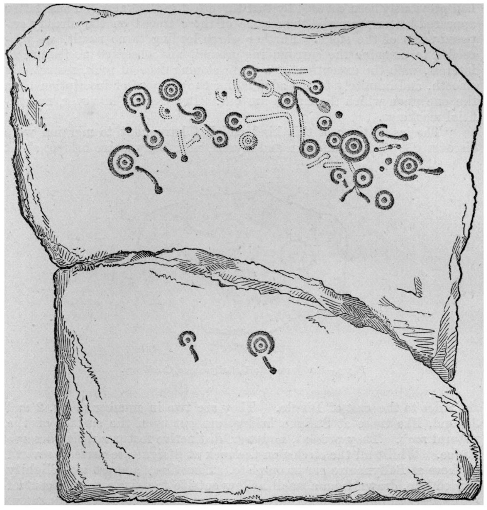
This is one of two impressive petroglyphs that were discovered by Lord Dunraven and Rev. James Graves in the mid-1870s, “near Ballynasare bridge”, but which are now lost (the other one is the Ballynasare Bridge (2) stone). This carving is the larger and more impressive of the two that they found, on which he described some of the carved rings as “incomplete.” Although Graves (1877) didn’t give a detailed description of the carving, this drawing (right) more than makes up for his lack of words. One of the features that he did tell us about was one of the primary motifs in this design which modern students like to call radial grooves. “Sometimes,” he wrote, “a short and slightly curved line, drawn from a hollow outside the circle to the central cup, passes through the open part of the circumference. More frequently, this line stops short just as it reaches the break in the circle.”
The grid reference here is an approximation given in Cuppage’s (1986) excellent survey, who told that its “precise location is not now known and may have been in any of the four townlands which converge at the bridge.” Hopefully it’ll be hiding away in some undergrowth, awaiting the attention of an antiquarian explorer. Are there any local folk who are able to help us out with this one?
References:
Cuppage, Judith, Archaeological Survey of the Dingle Peninsula, Oidhreacht Chorca Dhuibhne: Ballyferriter 1986.
Graves, James, “On Cup and Circle Sculptures as Occurring in Ireland,” in Journal Royal Society Antiquaries, Ireland, volume 4 (4th series), April 1877.
Cup-Marked Stone (lost): OS Grid Reference – Q 6014 0226
Archaeology & History
A cup-marked stone that was reported at this position in the 1940s by the Kerry Archaeological Survey (KAS) had disappeared by the time Judith Cuppage (1986) wrote her survey. She told that “there is no visible trace or local knowledge of the” carving. It may well have been destroyed. Seemingly KAS made no notes or sketches of the site. (WTF?!?!?)
References:
Cuppage, Judith, Archaeological Survey of the Dingle Peninsula, Oidhreacht Chorca Dhuibhne: Ballyferriter 1986.
Cup-and-Ring Stone (lost): OS Grid Reference – Q 46 00
Archaeology & History
This lost carving probably still exists, but in all likelihood is well overgrown by vegetation. It was in that state of affairs when Rev. Orpen (1908) wrote about it more than a hundred years ago in his essay on the petroglyphs between Lispole and Dingle. After describing and illustrating several carvings in the area, he told:
“I may mention here that further west, near Ballintaggart, at Ballywoonig, there is another single cup and circle which I found on a rock, the last of which was covered with clay and grass. I had these removed, hut nothing further was disclosed.”
Sadly, he left us with no sketch. His wording suggests that the carving is close to the southern boundary of Ballinvownig, pehaps near the souterrains near Ballintaggart house…? Perhaps some local antiquarian explorers might be able to find out where it’s hiding—although it will doubtless be covered in vegetation.
References:
Cuppage, Judith, Archaeological Survey of the Dingle Peninsula, Oidhreacht Chorca Dhuibhne: Ballyferriter 1986.
Orpen, R., “Antiquities near Lispole, Co. Kerry,” in Kerry Archaeological Magazine, volume 1, 1908.
Cup-and-Ring Stone (removed): OS Grid Reference – NT 12364 32627
Also Known as:
Drumelzier Carving
Archaeology & History
Position of stone in cairn
A carving that was located at the edge of a cairn on a knoll on the east-side of the River Tweed, this is an odd design that now lives in Edinburgh’s central museum: odd, inasmuch as the design looks as if it’s a typical cup-and-ring carving, yet none of the cups on this stone were ever hollowed or pecked out, and so the “cups”, so to speak, are actually small rings (if that makes sense!). There are a number of similar unhollowed “cups” on other carvings that are found associated with prehistoric tombs, so perhaps this aspect was something of a burial trend—amongst a very small tribal group, perhaps… It’s an element that was remarked upon in Simpson & Thawley’s (1972) examination of petroglyphs in neolithic tombs that were called “passage grave style” carvings: a sort of dyslexic cup-and-ring design no less! The intriguing thing about this carving is that it’s one in a small cluster of dyslexic cup-and-rings that are found in this part of Scotland—in an area where rock art itself is pretty scarce. Which begs the question: was it a local tribal style? Anyhow…
The carving was first uncovered when J.H. Craw (1930) excavated the aforementioned cairn, finding therein a number of cists. There’s speculation that the petroglyph might originally have been a covering stone for one of the cists, but we don’t know for sure. Craw described the carving as follows:
Craw’s 1930 sketchRon Morris’ 1981 sketch
“The ring-marked slab…measures 3 feet by 2 feet by 6 inches. It lay at the north side of the cairn (highlighted in sketch, PB), outside the encircling ring, but may originally have been the cover of cist No.2. On the upper side are five shallow ring-markings, four being double and one single. The former measure 3 inches to 4 inches in diameter, and the latter 1¾ inch. The figures are thus much smaller than in typical cup-and-ring-marked stones, and the lines are only ¼ inch in width. The only similar markings known to me are on a slab which I found a number of years ago near the site of several former cairns, and forts at Harelawside near Grant’s House, Berwickshire. The stone is now in our Museum.”
The “museum” in question being Edinburgh’s National Museum (I don’t know if it’s in a box somewhere or on public display, which is where it needs to be). If anyone can get a good photo of this carving, please send it to us or add it on on our Facebook group.
Morris, Ronald W.B., “The Cup-and-Ring and Similar Early Sculptures of Scotland; Part 2 – The Rest of Scotland except Kintyre,” in Transactions of the Ancient Monuments Society, volume 16, 1969.
Morris, Ronald W.B., The Prehistoric Rock Art of Southern Scotland, BAR: Oxford 1981.
Ritchie, Graham & Anna, Edinburgh and South-East Scotland, Heinnemann: London 1972.
Royal Commission on the Ancient & Historical Monuments, Scotland, Peeblesshire – volume 1, Aberdeen University Press 1967.
Simpson, D.D.A. & Thawley, J.E., “Single Grave Art in Britain,” in Scottish Archaeological Forum, no.4, 1972.
Acknowledgements:Huge thanks for use of the Ordnance Survey map in this site profile, reproduced with the kind permission of the National Library of Scotland.
Cup-and-Ring Stone (lost): OS Grid Reference – Q 43 11
Archaeology & History
Judith Cuppage (1986) recounted that in the unpublished Minutes of the County Kerry Field Club for 1944, mention was made of a multiple-ringed petroglyph that hasn’t been seen since. It sounds quite impressive. She told how they’d,
“discovered a stone bearing a cup-and-gapped circle and a cup-and-3 gapped circles, “on the fence opposite the church” at Camp. Mortar still adhering to the stone as if it had been removed from a building.” Adding that, “neither its original provenance nor present whereabouts are known.”
Surely some good wise local still knows where this olde stone lives? In a garden perhaps…? It would be good to know that it’s still alive and well.
References:
Cuppage, Judith, Archaeological Survey of the Dingle Peninsula, Oidhreacht Chorca Dhuibhne: Ballyferriter 1986.
Acknowledgements:Huge thanks for use of the Ordnance Survey map in this site profile, reproduced with the kind permission of the National Library of Scotland.
Less than a mile east of Callander on the main A84 road, nearly 300 yards just past the entrance into the Keltie Bridge caravan park, take the tiny road on your left (north) and barely 100 yards along where a small crossroads can be said to exist, go straight forward up the tiny single-track road ahead of you. Literally 0.62 miles, or 1km up, park on the right-side of the road where a small grassy track runs up the slope. From here, you need to keep walking up the road itself, bearing right just past the small bridge and, about 350 yards along you’ll see a notable rise in the field on your right less than 100 yards in. Head straight for it!
Archaeology & History
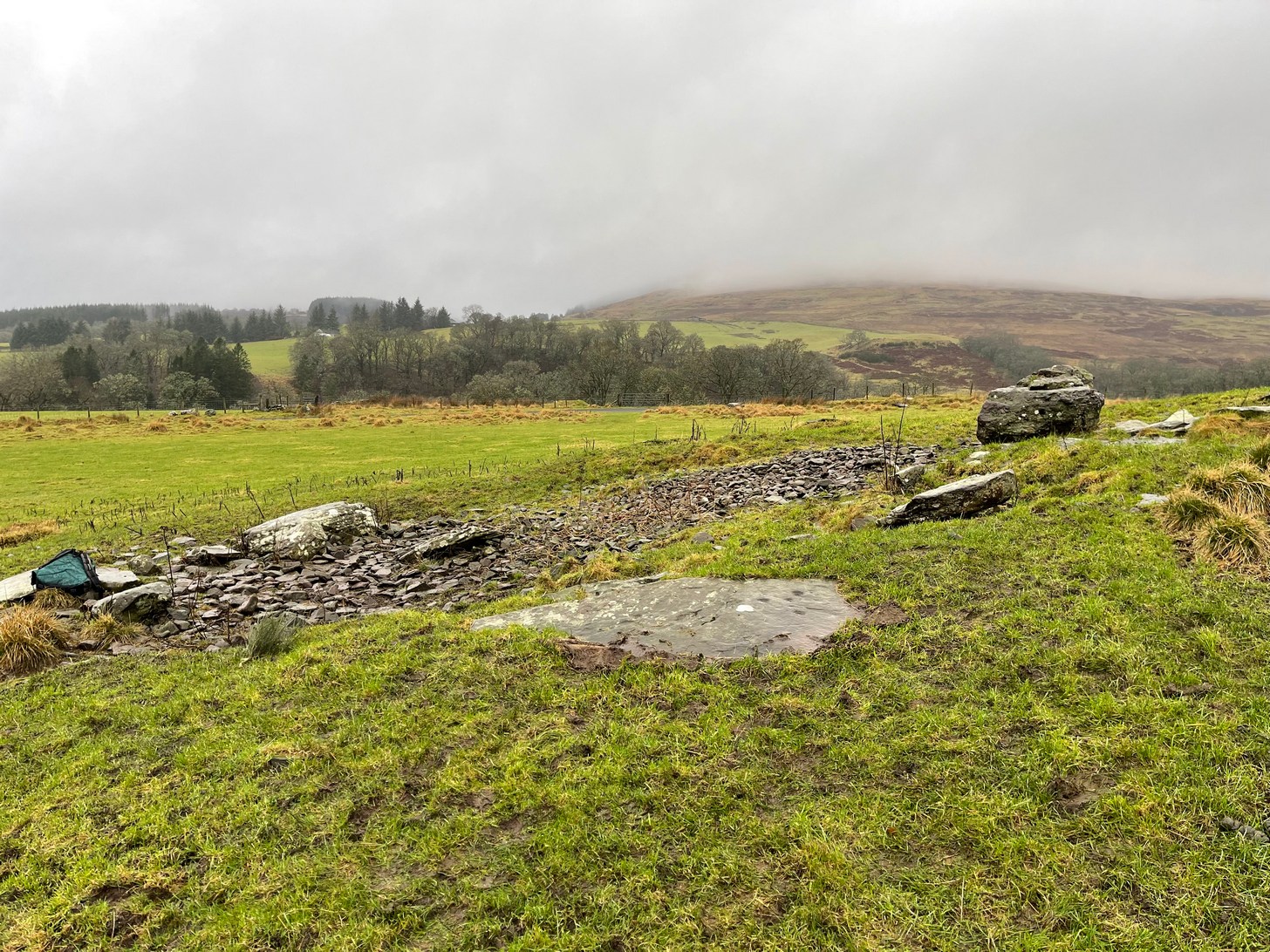
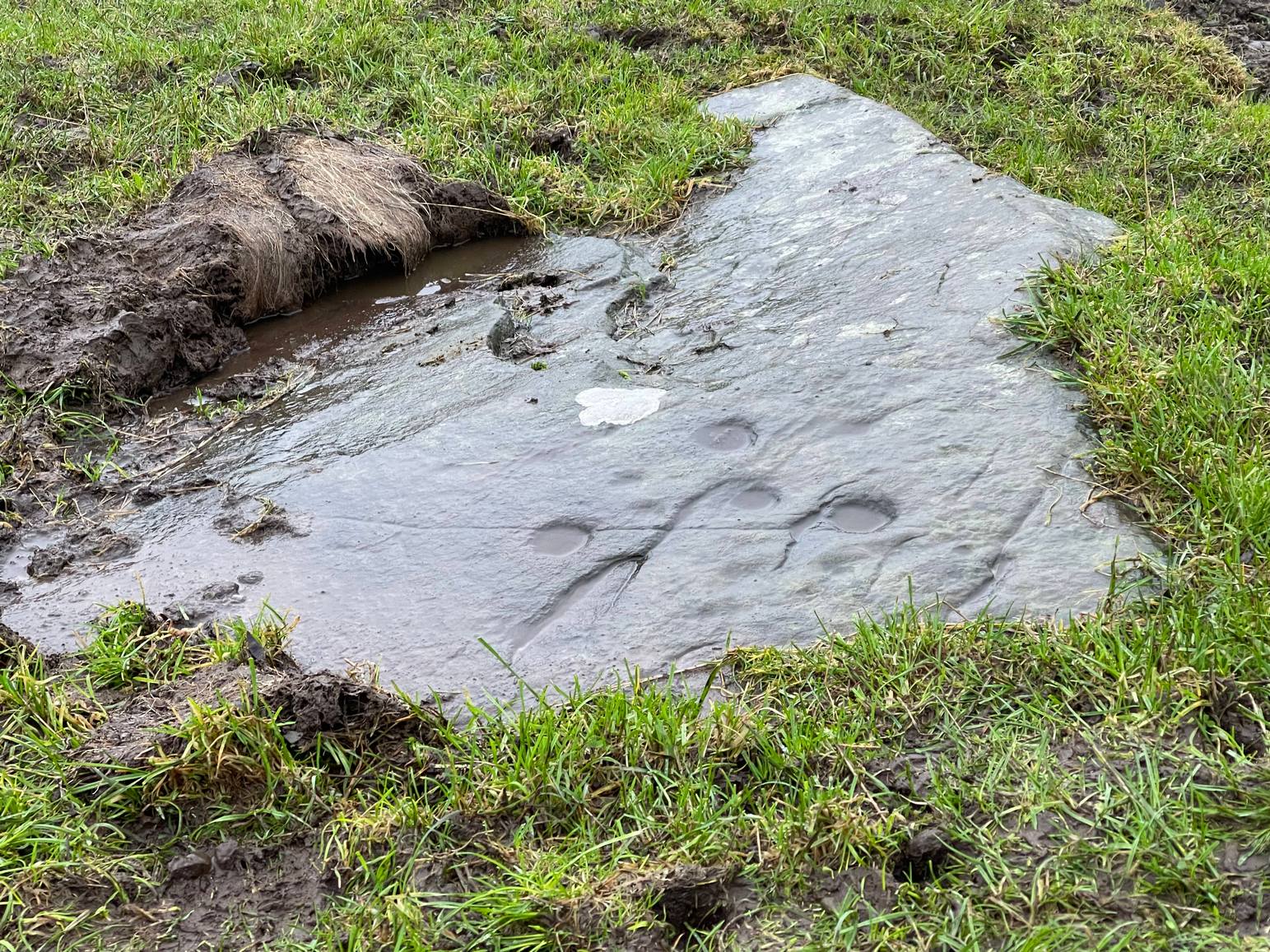
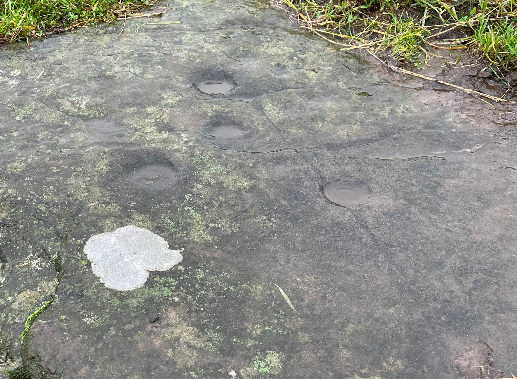
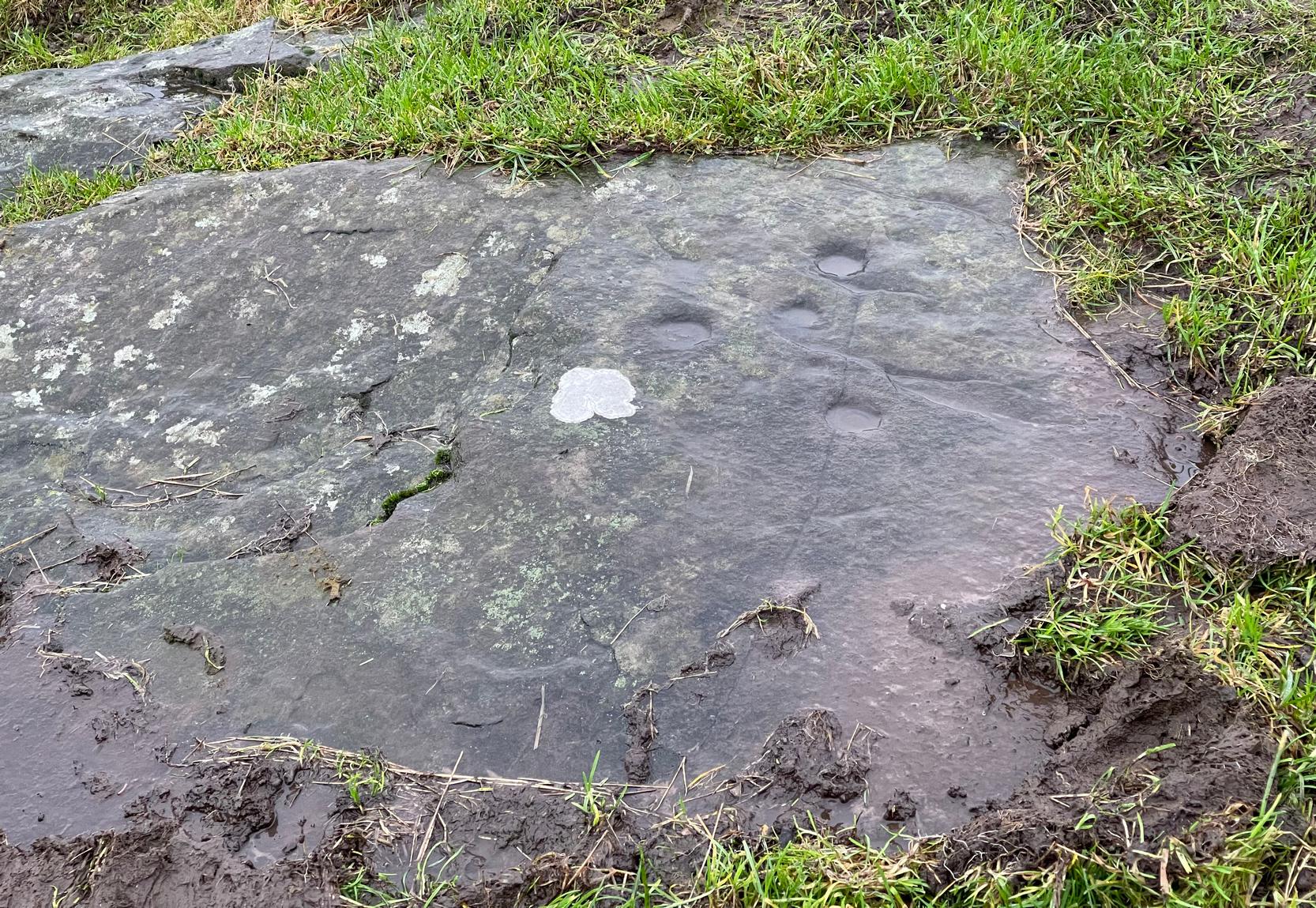
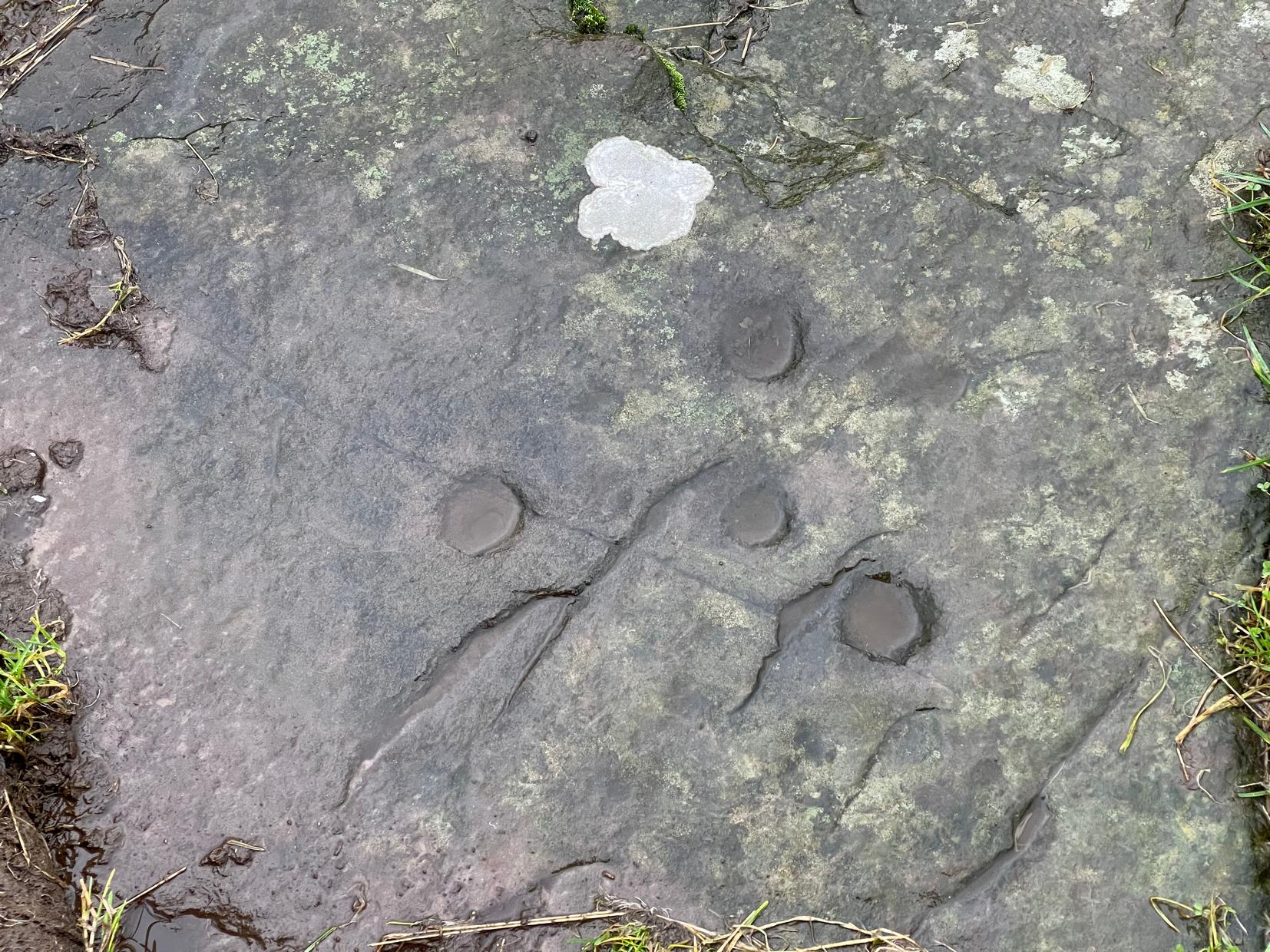
Despite this being a very basic simplistic design, I’m somewhat disappointed in myself as when we visited here, She was pouring with rain and for some reason or other I didn’t indulge myself in the soaking muddy ground and peel back the dung-infested turf to see the entire surface of this stone—and so, as a result, didn’t see the carving in its entirety. I’d have got soaked and been covered in shit! 🙂 But later this day we were visiting an antique centre and book-dealer straight afterwards, so for once I couldn’t play in the mud. Damn those neat and tidy folk!
It’s nowt special to look at in all honesty, but it’s in a good state of preservation as it was seemingly uncovered in pretty recent times beneath the curious large mass of loose stones right next to it. The stone mass gives the impression of it being a ruined cairn, but seems more likely to be a clearance cairn that was piled up, quite fortuitously, next to the cup-marked rock.
The carving consists of eight cup-marks (not all shown in these photos): five large and prominent, one not so prominent, and two that are small and very shallow. The more distinct cups would seem to have been worked and re-worked many times, obviously possessing a practical nature of some sort. As we can see in the photos, four of the larger cups stand out, whilst the small ones can be difficult to see. If there are any petroglyphic locals who fancy getting up here to clear the rest of the stone to see if there are more cup-marks underneath the soil, please let us know! Perhaps check it out when you’re looking at the nearby cairns at Ballachraggan and beyond.
References:
Main, Lorna & Page, R., “Easter Brackland, Stirling,” in Discovery & Excavation Scotland, volume 2, 2001.
About mile south of Northchurch, on the far side of the A41 dual carriageway, somewhere past the old crossroads (or perhaps even at the crossing) an ancient tree lived—and truly lived in the minds of local people, for perhaps a thousand years or so. Mentioned in the Lay Subsidy Rolls in 1307, the Cross Oak gave its name to the old building that once stood in the trees and the hill itself, at the place now known as Oak Corner. Whether or not a “cross” of any form was set up by this old oak, records are silent on the matter. Its heathen ways however, were pretty renowned! (a plaque should be mounted here)
Folklore
The first reference I’ve found of this place is in William Black’s (1883) folklore survey where he told that “certain oak trees at Berkhampstead, in Hertfordshire, were long famous for the cure of ague”—ague being an intense fever or even malaria. But a few years later when the local historian Henry Nash (1890) wrote about this place, he told that there was only one tree that was renowned for such curative traditions, that being the Cross Oak. He gave us the longest account of the place, coming from the old tongues who knew of it when they were young—and it had it’s very own ritual which, if abided by, would cure a person of their malady. “The legend ran thus”, wrote Mr Nash:
“Any one suffering from this disease was to proceed, with the assistance of a friend, to the old oak tree, known as Cross Oak, then to bore a small hole in the said tree, gather up a lock of the patient’s hair and make it fast in the hole with a peg, the patient then to tear himself from the tree, leaving the lock behind, and the disease was to disappear.
“This process was found to be rather a trying one for a weak patient, and by some authority unknown the practice was considerably modified. It was found to be equally efficacious to remove a lock of hair by gentle means, and convey it to the tree and peg it in securely, and with the necessary amount of faith the result was generally satisfactory. This is no mere fiction, as the old tree with its innumerable peg-holes was able to testify. This celebrated tree, like many other celebrities, has vanished, and another occupies its place, but whether it possesses the same healing virtues as its predecessor is doubtful. It is however a curious coincidence, that the bane and the antidote have passed away together.”
The lore of this magickal tree even found its way into one of J.G. Frazer’s (1933) volumes of The Golden Bough, where he told how the “transference of the malady to the tree was simple but painful.”
Traditions such as this are found in many aboriginal cultures from different parts of the world, where the spirit of the tree (or stone, or well…) will take on the illness of the person for an offering from the afflicted person: basic sympathetic magick, as it’s known. Our Earth is alive!
References:
Black, William G., Folk Medicine, Folk-lore Society: London 1883.
Frazer, James G., The Scapegoat, MacMillan: London 1933.
Jones-Baker, Doris, The Folklore of Hertfordshire, B.T. Batsford: London 1977.
Nash, Henry, Reminiscences of Berkhamsted, W. Cooper & Nephews: Berkhamsted 1890.
Acknowledgements:Huge thanks for use of the Ordnance Survey map in this site profile, reproduced with the kind permission of the National Library of Scotland.
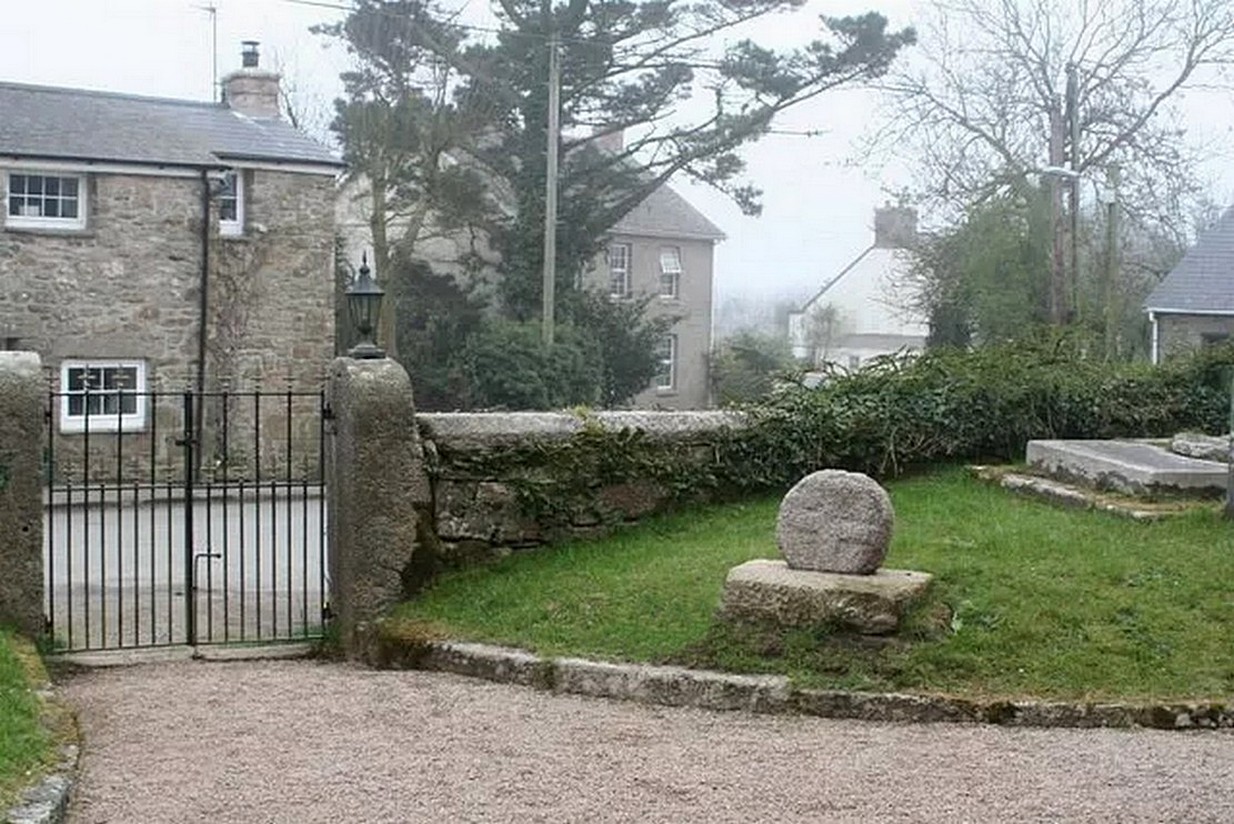
Nice ‘n easy: get into the village and walk through the church gates and there, on your left on the grass verge, a plinth and the cross-head sits before thee!
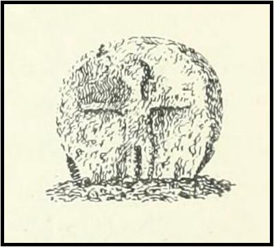
Archaeology & History
When the great Arthur Langdon (1896) wrote about Crowan’s cross-head, he was puzzled. At the time it was in the garden of a local surveyor in the nearby village of Praze-an-Beeble, but its origins seemed mysterious. The surveyor in question, a Mr William Carah, wrote to Langdon and said,
“It seems a mystery where the cross we have originally came from. A friend of mine, living abroad at present, saw it, I think, at a farm-place, being used as a bottom for a beehive. He asked the people for it, intending to fix it somewhere. At any rate, when he left England he had not done so, and at my request they gave the cross to me.”
The condition of the cross-head wasn’t too good and Langdon suggested it had “received some very rough treatment” – no doubt when it was hacked from its shaft. With his usual precision he gave the dimensions of the cross-head as follows:
“Height, 1 ft. 6 in.; width, 1 ft. 8 in.; thickness: at the bottom 6½ in., at the top 5½ in.
Front. — Part of a small conventional figure of Christ, extending to the knees, at which point the fracture occurred which separated the head from the shaft.
Back. — The remains of a mutilated Latin cross in relief.”
The stone shaft or menhir that once supported this carved head has, it would seem, long since been destroyed.
References:
Blight, J.T., Ancient Crosses and other Antiquities in the West of Cornwall, Simpkin Marshall: London 1858.
Courtney, R.A., The Evolution of the Wheel Cross, Beare & Sons: Penzance 1914.
Doble, Gilbert H., A History of the Parish of Crowan, King Stone Press: Shipston-on-Stour 1939.
Langdon, Andrew, Stone Crosses in West Cornwall, Federation of Old Cornwall Societies 1999.
Langdon, Arthur G., Old Cornish Crosses, Joseph Pollard: Truro 1896.
Travel along the B867 road from Bankfoot to Dunkeld (running roughly parallel with the A9) and you’ll reach the hamlet of Waterloo about one mile north of Bankfoot. As you approach the far end of the village, keep your eyes peeled for the small turning on your left and head up there for just over a mile. The road runs to a dead end at Meikle Obney farm, but shortly before reaching there you’ll pass this large standing stone on the right-side of the road, just along the fence-line. It’s almost impossible to miss!
Archaeology & History
This is one of “the large rude upright stones found in the parish” that William Marshall (1880) mentioned briefly, amidst his quick sojourn into the Druidic history of Perthshire. It’s an impressive standing stone on the southern edges of the Obney Hills that doesn’t seem to be in its original position. And it’s another one that was lucky to survive, as solid metal staples were hammered into it more than a hundred years ago when it was incorporated into the fencing, much like the massive Kor Stone 6½ miles south-west of here.
Site shown on 1867 mapWitch’s Stone at roadside
Shown on the first Ordnance Survey map of the area in 1867, its bulky 6½-foot-tall body stands all alone on this relatively flat plain, with open views to the east, south and west. It gave me the distinct impression that it was once part of a larger megalithic complex, but I can find no additional evidence to substantiate this. Call it a gut-feeling if you will. Intriguingly, the closest site to this are two standing stones just out of view literally ⅔-mile (1.07km) to the northeast, aligned perfectly to the Witch’s Stone! Most odd…
Folklore
The story behind this old stone is a creation myth that we find all over the country, but usually relating to prehistoric tombs more than monoliths. The great Fred Coles (1908) wrote:
“the common legend is told of a witch who, when flying through the air on some Satanic behest, let the Stone fall out of her apron.”
Marshall, William, Historic Scenes in Perthshire, William Oliphant: Edinburgh 1880.
Stewart, Elizabeth, Dunkeld – An Ancient City, Munro Press: Perth 1926.
Acknowledgements:Huge thanks for use of the Ordnance Survey map in this site profile, reproduced with the kind permission of the National Library of Scotland.