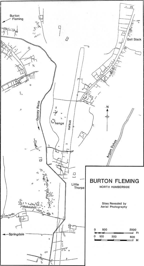
Plan of Rudston D Cursus & associated monuments (after I.M. Stead 1976)
To the north of Rudston village and its giant standing stone, running roughly parallel with the divinatory waters of the Gypsey Race river and passing a mass of prehistoric remains en route, we find one the biggest prehistoric cursus monuments in the British Isles: the Rudston D cursus. More than twice as long as any of the three other cursus monuments nearby, its northern end or ‘terminal’ is flattened in nature (others are rounded) and is due east of the village of Burton Fleming starting at the intriguingly-named Maidens Grave field, just as the land begins to rise at TA 099 717. From here it begins its almost southern trajectory and runs almost dead straight for several hundred yards until edging, ever so slightly in direction, to a slightly more secure southern alignment. Past the site of the Rudston henge, the cursus broadens out slightly and, as it reaches the farmlands of Littlethorpe, edges slightly further to a more decisive direct southern route. The cursus then maintains a dead straight course for another mile, heading straight for, and stopping just short of the Rudston monolith in its modern churchyard. A short distance before we reach its southern end, archaeologists found that a section of the Cursus C monument cut right across it. Altogether, the Rudston D Cursus is more than 4km (2.3 miles) long! At its narrowest width, this monument is a mere 160 feet (50m) across, and at its widest is 280 feet (90m). A giant by anyone’s standard!
Along the entire length of this continuous ditch and inner bank there were just 3 small cuttings on the western side and three on the east, but two of the eastern openings were quite large. Some of these openings were affected by natural elements and others by modern agriculture. Today, much of this gigantic ritual monument (as the archaeologists call them) is not visible at ground level.
In visiting this area, make yourself aware of the other monuments in this class: the Rudston A cursus and Rudston B cursus, southeast and southwest of here respectively. A full multidisciplinary analysis of the antiquities in this region is long overdue. To our ancestors, the mythic terrain and emergent monuments hereby related to each other symbiotically, as both primary aspects (natural) and epiphenomena (man-made) of terra mater: a phenomenon long known to comparative religious students and anthropologists exploring the animistic natural relationship of landscape, tribal groups and monuments.
References:
Burl, Aubrey, Rites of the Gods, J.M. Dent: London 1981.
Harding, Jan, ‘Pathways to New Realms: Cursus Monuments and Symbolic Territories,’ in Barclay & Harding, Pathways and Ceremonies: The Cursus Monuments of Britain and Ireland, Oxbow: Oxford 1999.
Loveday, Roy, Inscribed Across the Landscape: The Cursus Enigma, Tempus: Stroud 2006.
Pennick, Nigel & Devereux, Paul, Lines on the Landscape, Hale: London 1989.
Stead, I.M., ‘La Tene Burials between Burton Fleming and Rudston,’ in Antiquaries Journal, volume LVI Part II, 1976.
Of the four giant linear cursus monuments that were laid out around the landscape that holds Britain’s largest standing stone—the Rudston monolith—this one, the Rudston ‘C’ cursus, is the one we know the least about. This is mainly due to it receiving the minimum of archaeological attention, which can be forgiven round here as there is so much material to explore! Traces of the cursus at ground level are also quite negligible. Thankfully however, like the other cursus monuments nearby, some of the site can be made out on GoogleEarth.
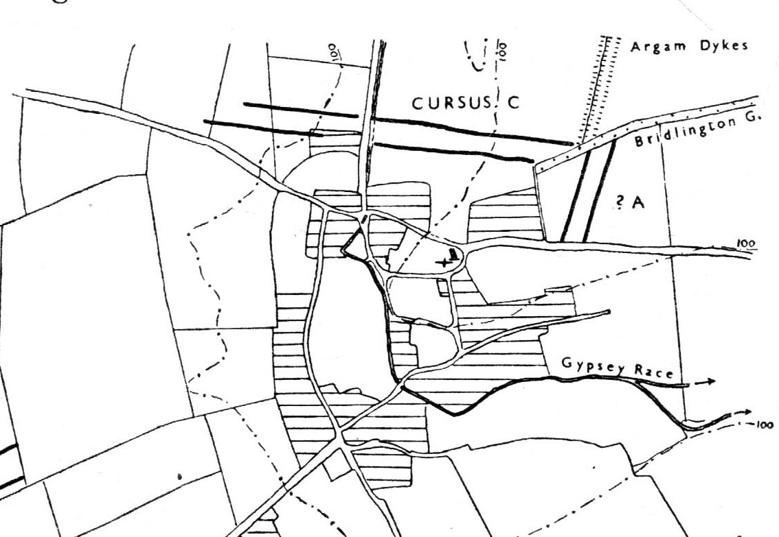
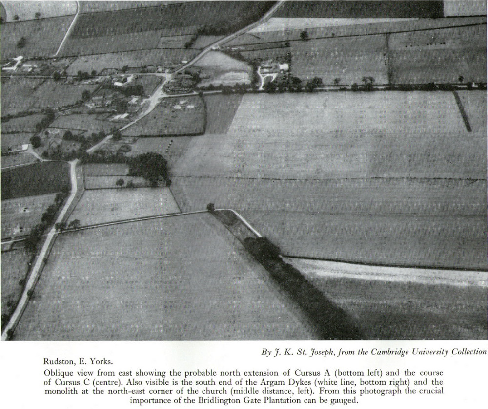
The alignment of this cursus runs east-to-west, cutting across the Cursus D monument and then running above the northern course of Nature’s curious river known as the Gypsey Race, which local folklore ascribes as being used in animistic divinatory practices. Cursus C was first noticed in aerial photographs taken by Prof. J.K. St. Joseph in 1961 and first described by D.P. Dymond (1966) a few years later, who told us:
“Immediately north of the village (Rudston), two parallel ditches, about 60 yards apart, are visible as crop-marks running east-west for 1000 yards… As they are too far apart to be considered as road-ditches and are similar to the linear ditches (of Rudston A and B), they are best interpreted as a fragment of a third cursus, C. The western end fades out near the York road as it climbs onto high ground, while at the east the ditches disappear into Bridlington Gate Plantation. Like Cursus A, this also crossed the Gypsey Race. Approximately 1½ miles northwest of the last westward point of these ditches is the presumed site of two lost long barrows, joined together at one end. There may, therefore, have been an original connection between Cursus C and these long barrows.”
First faint photo of Cursus C
His final remark is quite a good one! And since Dymond’s initial description (according to the PastScape lads anyhow), Cursus C has been found to be much longer than the initial 1000 yards, growing another 500 yards at least! The final point or ‘terminal’ on the eastern end still remains hidden, as it was intruded upon by the later Argham Dyke and the trees. The start or western terminal also remains unfound, so we don’t know for sure the exact length of this giant neolithic ‘line on the landscape’, as Pennick and Devereux (1989) call them.
References:
Dymond, D.P., “Ritual Monuments at Rudston, E. Yorkshire, England,” in Proceedings of the Prehistoric Society, volume 32, 1966.
Harding, Jan, ‘Pathways to New Realms: Cursus Monuments and Symbolic Territories,’ in Barclay & Harding, Pathways and Ceremonies: The Cursus Monuments of Britain and Ireland, Oxbow: Oxford 1999.
Loveday, Roy, Inscribed Across the Landscape: The Cursus Enigma, Tempus: Stroud 2006.
Manby, T.G., “The Neolithic in Eastern Yorkshire,” in Archaeology in Eastern Yorkshire, University of Sheffield 1988.
Pennick, Nigel & Devereux, Paul, Lines on the Landscape, Hale: London 1989.
Stead, I.M., ‘La Tene Burials between Burton Fleming and Rudston,’ in Antiquaries Journal, volume LVI Part II, 1976.
From Blackford on the north side of the A9, cross over and take the small B-road which quietly runs up and over Sheriffmuir towards Dunblane. After a mile, keep your eyes keen for the approaching woodland on your right-hand side; for in the field just before the woods, you’ll see a patch of grass near the corner of the field with a long stone poking out of it. That’s it!
Archaeology & History
It seems that very little has been written about this monolith in any of the archaeology texts, but it’s ascribed locally to be a fallen standing stone. The site’s described in Finlayson’s (2010) fine local megalith guide where he points out how it’s in line with other nearby standing stones at Gleneagles and the White Stone – and the line is damn close!
…and from another angle…
With a quartz vein running through it, the stone lays some thirteen feet long and was, at some time in the not-too-distant past, readied to be quarried, as evidenced by the chisel-marks cut into it, prior to the usual destruction. But this time, for some reason, someone must have come to the rescue and prevented its demise…thankfully…
The farmer annually cuts around the fallen stone, shaped like a long boat (hence the name), near the top corner of the field. It would have looked damn good when stood upright, standing about ten feet in height and visible for a good distance. But today it’s quite forlorn laid here, seemingly alone, in this quiet part of the country, and is probably only one of interest to hardcore megalithomaniacs amongst you!
References:
Finlayson, Andrew, The Stones of Strathearn, One Tree Island: Comrie 2010.
From Comrie town centre take the road south across Dalginross Bridge over the river, heading towards Braco, up the winding B827 road for 2-3 miles until you reach a small crossroads (you can easily miss it, so watch out!). Turn left and, about a mile on, keep your eyes peeled – either for the standing stone in the field on your left, or the dirt-track to Craigneich Farm 100 yards further on.
Archaeology & History
…and again, looking east
This is a large standing stone in a truly beautiful setting. More than six-feet tall, it stands amidst a gorgeous atmosphere just off the quiet roadside and has been all-but neglected by most archaeological surveys. Thankfully it was one of the many impressive monoliths in this district that was described in one Fred Coles’ (1911) fine surveys. Described in conjunction with the even more massive standing stones on the slopes to the south, he told:
“This Stone is one mile and a furlong SSE of the last, on the north side of the road between Straid and Shillinghill, at 514 feet above sea-level. The locality lies to the north of Aodan Mohr, which is the name given to the upper portion of Dunruchan. .. Its base is of an extremely irregular four-sided shape, having a jutting-out ledge on the south (see drawing). In basal girth it measures 15 feet 9 inches, and in height 6 feet 4 inches. The longest axis points N. 33° E.. by S. 33° W .”
Craigneich stone (Coles 1911)
Others may have once stood in close attendance, as the Chronicles of Strathearn (1896) tells how at Blarinroar (the name of the fields here) there were standing stones twenty feet tall! Cole thinks this to be an error based on the megaliths of Dunruchan, half-a-mile to the south. On the other side of the road from here, in the hedgerow, lies a fallen stone covered in ages of moss.
The now singular upright has been linked, albeit tentatively, to the Dunruchan megaliths as part of a possible stone row (Burl 1993; Thom 1990), but this seems very unlikely.
In Edward Peterson’s (1996) survey of Pictish monuments, he thought the Craigneich stone may have been important to the Seal tribe in ages gone by, as he says there are some Pictish carvings on the stone:
“The heads of two seals are relatively clear, positioned near the centre of this stone. Not so clear is the head of a cat at the top right hand corner, and to the immediate left is another seal head. These are only a few of the animal heads appearing on this sea/seal-god standing stone.”
More antiquarian research is obviously required here. It’s a truly superb spot!
References:
Burl, Aubrey, From Carnac to Callanish, Yale University Press 1993.
Cole, Fred, “Report on Stone Circles in Perthshire, Principally Strathearn,” in Proceedings of the Society of Antiquaries, Scotland, volume 45, 1911.
Along the A9 dual carriageway between Blackford and Auchterarder, take the A823 road south, up the Glen Eagles road as if you’re heading towards Pool of Muckhart and Dunfermline. Less than 100 yards up the road, turn immediately right and go past the standing stone of Gleneagles B for a coupla hundred yards or so, where there’s a left turn (down to Peterhead Farm). Stop here and look into the field in front of you. You can’t really miss it!
Archaeology & History
Gleneagles ‘A’, gazing west
This short standing stone, more than 3ft tall, has an elegance about it which megalith lovers alone will understand! Maybe it’s the setting; maybe the feel of the land; or maybe something else. I dunno… On my first visit to the site, Nature was wearing a grey overcast cloak, but the site and I didn’t seem to care; and although the view from here doesn’t have the same grandeur of Glen Eagles to view as its companion stone a few hundred yards to the east might have, there felt a greater welcoming at this smaller stone. Odd, considering this monolith had been knocked over and re-positioned by the farmer in the not-too-distant past. Anyway…less of this subjective nonsense of feelings from the landscape and megaliths! Utter drivel all of it!
The earliest measured account of the stone is to be found in Mr Hutchison’s (1893) essay, where he notes this and its companion close by, giving us the dimensions of this monolith:
“This (stone) is roughly columnar in shape, but wider at the base than above. Its height is 3ft above ground; circumference at base 6ft. 5in., diminishing to 4ft. 2in at the top. It is of metamorphic schist. The line of direction between these two gives a horizontal angle of 260°.”
Since that day, in the mass of archaeology essays that have been scribed, this smoothed upright gets only a minimal description. Charles Calder’s (1947) account is typical, saying simply that it is,
“Somewhat cylindrical in form with a girth of 7 feet at the base, it rises with a decided tilt towards the west to a height of 3 feet 10 inches above ground-level.”
The stone fares better in Andrew Finlayson’s (2010) fine local survey of megalithic ruins, where he points out that this and its compatriot stone Gleneagles B, are in an alignment with the fallen Boat Stone and the upright White Stone, a few miles to the southwest. This line works on 1:50,000 map, but when transferred to larger-scale surveys, the alignment misses each outlying site by 20-30 yards here and there.
Standing Stones (destroyed): OS Grid Reference – NN 7643 2086
Archaeology & History
Site shown on 1886 OS-map
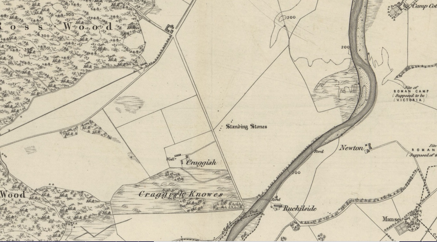
Highlighted on the 1866 OS-map was an impressive cluster of standing stones that sadly met their demise sometime around at the end of the 19th century. They were mentioned to “still exist” when the local writer Samuel Carment passed them in 1882, but had been destroyed by the time the Ordnance Survey lads resurveyed here in 1899. Altogether there were at least six of them, standing aligned sharply northeast-southwest and were described in one of Fred Coles’ (1911) essays, who lamented their passing. Listed in the stone row surveys by Burl (1993) and Thom (1990), the prime description we have of them was by Cole himself, who told:
“This site has also been wantonly bereft of its group of megaliths. Up to so recent a date as 1891 there were several. These were shown on the (Ordnance Survey map) as three in one line and two in another, on a field about one furlong NE of Craggish farmhouse, close to the road coming down from Ross, and nearly a quarter-mile NW of the ford across the Ruchil at Ruchilside.”
In Finlayson’s (2010) colourful survey of the local megaliths he told that the stones,
“Stood, by the road, in what is now ‘The Whinney Strip’: a boulder-strewn strip of land 20m wide dividing up otherwise flat and even grazing land.”
References:
Burl, Aubrey, From Carnac to Callanish, Yale University Press 1993.
Cole, Fred, “Report on Stone Circles Surveyed in Perthshire, Principally Strathearn,” in Proceedings of the Society of Antiquaries, Scotland, volume 45, 1911.
Thom, A., Thom, A.S. & Burl, Aubrey, Stone Rows and Standing Stones – 2 volumes, BAR: Oxford 1990.
Acknowledgments: Big thanks for use of the early edition OS-map in this site profile, Reproduced with the kind permission of the National Library of Scotland.
Take the B824 road that runs between Dunblane and Doune and, whichever direction you’re coming from, watch out for the large statue of David Stirling by the roadside (y’ can’t really miss it!). Stop here. Then, walk along the dirt-track into the field by the side of the statue, keeping your eyes peeled 50 yards along, for the upright stones in the field on your right, at the top of the brow of the hill.
Archaeology & History
Glenhead Farm standing stones
A few hundred yards south of the large Glenhead Standing Stone, we come across this curious small row of three reasonably large standing stones which — the more you look at them — give the distinct impression that they may be the remains of a large prehistoric tomb. But archaeology records are silent on this matter and we must contend with what we can see. At the northernmost end of the row, a fourth stone lays amongst the vegetation: it may have once stood alone, or maybe been snapped from its fellow monolith. 20 yards south is a large mass of stone; perhaps from an old building, perhaps cairn spoil (does anyone know?)
The local historian Moray Mackay (1984) thought that the line of stones here were once a part of something larger, saying:
“Originally it was probably a circle of six stones, with a seventh in the middle, and this central stone can still be identified by its flat top on which are the mysterious and well known cup-marks, much weathered but plainly visible. Close to the site, urns and stone hammers were unearthed last century.”
Glenhead stone row, looking north
Of the three remaining upright stones, it is the central one which has the cup-markings visible on its top and side (Allen 1882), with a lovely covering of almost luminous lichen giving it extra effect! (a separate TNA Site Entry for the cup-marked stone will be written in due course)
The famous astroarchaeologist Alexander Thom and his son (1990) described the place as,
“A three stone alignment showing about 33° N declination in one direction and 31° S in the other, but the azimuth comes from the stones only and so cannot be accurate. Perhaps the line is lunar to the hill in the SW…”
In Thom’s (1967) earlier work he posited that the alignment may relate to the rising of the star Capella around 1760 BC, but this is untrue. Thom’s error however, was not of his making, but due to the false dates that archaeologists ascribed to megalithic ruins at the time – dates which Thom used in his research, believing that the archaeological fraternity would know what they were talking about! In their collaborated text, Aubrey Burl added how,
“these stones stand on a hill summit at 360ft (110m) OD. The row is on a north-facing slope. Three stones stand. A fourth, prostrate, 6ft 6 in (2m) long, lies against the NE pillar. The row has a NNE-SSW axis. The northernmost stone is 3ft 6in high, the centre 4ft, and the SSW, characteristically the tallest, 6ft 6in… The line is about 27 feet (8.3m) long. The central stone has 23 cupmarks on its top and 4 more on its western side.”
…to be continued…
References:
Allen, J. Romilly, “Notes on some Undescribed Stones with some Cup-Markings in Scotland,” in PSAS 16, 1882.
Burl, Aubrey, From Carnac to Callanish, Yale University Press 1993.
Although cited in all modern archaeology texts as a series of four henge monuments, a recent article by J. Lewis & D. Mullin (2011) inform us that these “are not henges but belong to a tradition of enclosure that predates them and had a different function.” We’ll have to wait and see what they mean by that! In the meantime, we’ll have a quick scurry through the historical accounts of these four impressive ‘henges’ as Burl, Piggott and the others call ’em.
Surrounded at all angles by numerous barrows and tumuli, these four great henge monuments were shown on the 1887 Ordnance Survey map as a row of ‘Supposed Ring Forts’, when such ideas were in vogue, running in a line roughly SSW-NNE; the third one up having a couple of ponds within it. A brief early account of them was given by Harry Scarth (1859)—who was describing the series of nine round barrows a few hundred yards to the south—who told them to be “circular banks” each 500 feet across. The first more detailed account was in A.H. Allcroft’s (1908) classic text, where he wrote the following:
“…Close to the Castle of Comfort Inn, where the high road to Bristol crosses the line of the old Roman road running north-westward towards Charterhouse, there lies immediately west of the high road a series of four circles…all of one size, all of one plan, and all as mathematically exact as circles could well be when executed in such a soil and on such a scale. Although they have suffered greatly from the mining operations which have scarred all the Mendips, as well as from the plough — one of the four is almost obliterated — they are still quite easy to make out. The diameter of each is some 550 feet within the area, which is surrounded by a broad low vallum, and that again by a correspondingly broad and shallow ditch. The height of the vallum above the ditch, where best observable, is some 5 feet. There are no determinable entrances. The most southerly of the group is about 250 feet away from the second ; the second about 200 feet away from the third; and a line joining the centres of the first and third passes through the centre of the second also, and points 17° east of north. The fourth circle lies 1,200 feet away from the third, not in a right line with the others, but slightly to the west. Between the third and fourth circles passes the Roman road. Within the third circle is an old pond of some size.
“With every appearance of being all of one date, and that a venerable one, these circles lack every characteristic of military works. Their peculiar disposition, their painstaking regularity, and their identity of size, all suggest that they must, if really old, be of ritual, and perhaps of astronomical character”
Old drawing of the central hengesHenge 1, recently damaged (courtesy Pete Glastonbury)
Allcroft’s ideas of ritual and astronomy were pretty good for the period, as we take it for granted these days that such events occurred at henges — so the existence of four such sites right next to each other, would have made this one helluva place in neolithic and Bronze Age periods. A few years after Allcroft, the henges were described in Mr Burrow’s (1924) excellent illustrated survey, from which the drawing of the two central henges is taken (the two ‘R’s in the background highlight the line of the Roman road which runs past them). Burrow’s didn’t add much more of any note, simply telling:
“…in the fields north and south, are placed earth-work rings, each about 180 yards in diameter, on a line placed slightly north by east. The most northerly of these rings is almost obliterated, but the three on the west of the road from Chew Stoke to Oakhill are quite clearly defined, as my drawing (above) will show. I have been able to include two of these remarkable rings in my picture, the edge of the bank (which was, when I saw it, fringed with yellow gorse), being about 6 feet above the level of the ditch outside. It is generally supposed that these ringed earthworks were connected with some prehistoric ritual, and Hadrian Allcroft thinks were used for primitive astronomical observations or the construction of a primitive calendar.”
Tratman’s plan of Priddy HengesAnother view of Henge 1 (courtesy Pete Glastonbury)
Many years later when archaeologist K.S. Painter (1964) came to describe these henges, he listed them as “stone circles” (what the hell was he on!?), but this error may derive from the finding of several stones that once existed inside the southernmost Henge 1. These were uncovered following excavation work done here by E.K. Tratman (1967) and his colleagues, who explored and numbered the four henges—running from south to north—as follows:
“Circle 1: This is tolerably complete. A portion of the southwest quadrant has been destroyed by mining and there are three modern gaps in the ring. Mining has involved the ditch on the west and south, and to a small extent on the east. There is an irregular extensive hollow west of the centre and this too is a product of mining and contains a number of large stones so derived. The circle is not quite a true one, being flattened slightly on the west. The circle has a diameter from bank top to bank top of 520ft. The single original entrance is NNE of the centre. Stones 1 and 3-7 were removed by the farmer before excavation, but subsequent ploughing immediately after removal did not reveal any change in soil texture or colour. Stone 8 was placed in its present position quite recently. It is not known where it came from. Other stones have recently been placed on top of the bank east of the entrance by the farmer (1964-5). Stone 2 is in a relatively ancient position.
Circle 2: This is a true circle and its diameter and position of its entrance are similar to Circle 1. It has been considerably disturbed by mining. A group of stones (10-14) and stone 9 represent modern collections from the field. None of them is in its original position. There are two modern gaps in the ring.
Circle 3: This is distinctly flattened on the east and west. The N-S diameter is 520ft and the E-W 490ft from bank top to bank top. The northeast quadrant reported by Allcroft as being levelled is still traceable. The circle has been greatly disturbed by mining… The entrance is SSW of the centre, the opposite pole to circle 1 & 2, and has probably been widened, perhaps by miners. The marsh may be an original feature or the product of mining. The two ponds are certainly modern, and so is a small mound, which is probably spoil from the major pond.
Circle 4: This is incomplete. It has a diameter of 560ft, which is considerably larger than any of the others. The OS map shows only the eastern semi-circle remaining. However, the bank and in part the ditch can be traced…If the visible and proved end of the ditch on the SSW was intended to be at the edge of the causeway, then the entrance would have been in the same position as that of Circle 3.”
Very recently, a local land-owner quite deliberately bulldozed a large portion of the southern henge in this complex, destroying much of it. This act of criminal vandalism will hopefully not go unpunished and is, at the present time, going through the courts.
…to be continued…
References:
Allcroft, A. Hadrian, Earthwork of England, MacMillan: London 1908.
Burrow, Edward J., Ancient Earthworks and Camps of Somerset, E.J. Burrow: Cheltenham 1924.
Lewis, J. & Mullin, D., “New Excavations at Priddy Circle 1, Mendip Hills, Somerset,” in Proceedings of the University of Bristol Speleological Society, volume 25, 2011.
Painter, K.S., The Severn Basin, Cory, Adams & Mackay: London 1964.
Scarth, Harry M., “Some Account of the Investigation of Barrows on the Line of the Roman Road Between Old Sarum and the Port at the Mouth of the River Axe,” in The Archaeological Journal, volume 16, 1859.
Any remains of this once sacred site are now beneath the airport between Benson and Ewelme, a couple of miles northeast of Wallingford, on the eastern side of the River Thames. A great pity. It was one of the early cursus monuments discovered as a result of Major G.W. Allen’s many aerial surveys in southern England — as shown in his photo here — and subsequently described in Mr Leeds’ (1934) Antiquaries Journal article. A cluster of cursus monuments were built in this part of England in neolithic times, and Roy Loveday (2006) includes the Benson Cursus as an ingredient within the ‘sacred landscape’ region of what he calls “the Dorchester-on-Thames complex.” The Benson Cursus and surrounding regional monuments,
“in fact possesses features that would declare it as an inter-regional sanctuary if encountered in an historical setting; namely, intensity of monument construction, longevity of respect, addition of later exotic monuments with far-flung parallels, large numbers of burials, and placement in a landscape structured, partly at least, by other monuments. These elements recur from Delphi to Uppsala, and from Pachacarmaca to Mecca, at sites that Mircea Eliade (sic) has termed hierophanies — locations where the otherworld of gods and ancestors communicate with the living.”
Loveday’s 2006 planBenson Cursus plan (after Barclay & Lambrick)
It’s good to know that the correct paradigms are at last emerging from those archaeocentric minds!
In Mr Loveday’s (2006) plan of the cursus, no entrances could be found into the monument apart from a small section along the northeastern length of the structure (left). From its southernmost point, this giant monument runs along a SSW-NNE alignment — one echoed in other nearby cursuses — for 1192 yards (1090m) and is 71 yards (65m) across, covering 7.3 hectares in all. No internal structures were noted anywhere within the monument.
…to be continued…
References:
Barclay, A., Lambrick, G., Moore, J. & Robinson, M., Lines in the Landscape, OAU: Oxford 2003.
Benson, D. & Miles, D., The Upper Thames Valley: An Archaeological Survey of the River Gravels, Oxford Archaeology Unit 1974.
Eliade, Mircea, The Sacred and the Profane, Harcourt, Brace & World: New York 1959.
Leeds, E.T., “Rectangular Enclosures of the Bronze Age in the Upper Thames Valley, in Antiquaries Journal, 14:4, 1934.
Loveday, Roy, Inscribed Across the Landscape, Tempus: Stroud 2006.
Bittova journey this — but well worth it! From Broughton-in-Furness take the A595 road west, past Duddon Bridge for about another 1½ miles, turning right up the small single-track country lane beloved of city-mind drivers, up the fertile scruffy road, past Broadgate and stopping just before Cragg Hall Farm. There’s a dirt-track running up the back of Cragg Hall. Go up here and keep walking for a mile or so until, as you approach Swinside Farm and the fields open up in front of you, the stones begin to appear.
Archaeology & History
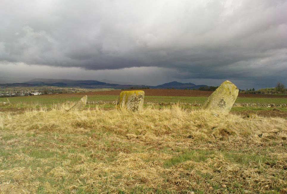
Swinside, looking east
The Swinside stone circle is Aubrey Burl’s favourite. And for good reason! Like other impressive megalithic rings of the region, the stones are large, well set, and the landscape holds the stones finely in the hills. Without the landscape here, Swinside (like Castlerigg and elsewhere) would not have such grandeur. When you sit in the ring, or walk round it, Knott Hill to the south was of obvious mythic relevance to the people who built this stone circle four or five thousand years ago. But this can be said of many of the surrounding crags. A few miles southwest we see the top of the haunted Black Combe rising into clouds, still speaking to some with spirits from animistic realms, long known to our ancestors. Following the skyline west and past the small falls of Whicham stream, whose name speaks of long past trees, we reach the near-west skyline with the cairn-looking pap of the Raven Crag, symptomatic of magickal rites calling to and beyond the circle. To the north is the symbolic ridge of Lath Rigg. Along the craggy eastern ridges from here you get the impression that you’re more in Argyll than Cumbria; and the break in the hills to the southeast reaches to the distant pinnacle of Kirkby Moor, where the midwinter sunrise emerged to tell of solar calendrical motions and the coming of the dark season to our megalithic tribes. But enough of the landscape!
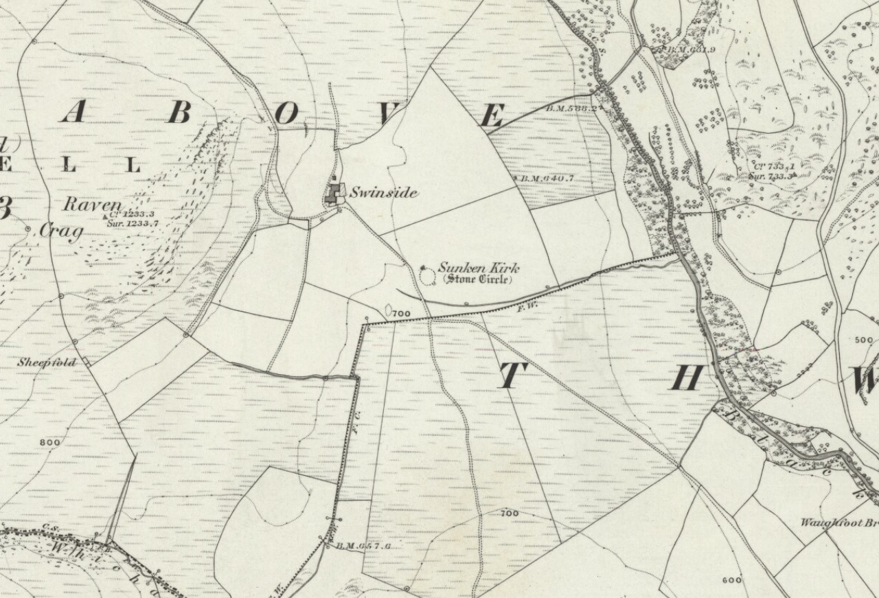
Swinside on 1867 OS-map
Although the name Swinside can be traced back to the 13th century, the local folk-name of the circle—Sunken Kirk—was mentioned for the first time as “the Chapell Suke” in Parish Registers of 1624. No earlier literary source has yet been identified, probably because of the isolation of the site and the lack of people writing about the area. Swinside stone circle is, just about, a perfect circle, give or take a foot here and there, holding the circular dome of the heavens within its domain. Yet despite its almost regal appearance, early references to the site seem scant. It seems to have been first described in William Hutchinson’s huge History of Cumberland (1794), where he told:
“In the neighbourhood of Millum, at a place called Swinside, in the estate of William Lewthwaite Esq., of Whitehaven, is a small but beautiful druidical monument; it is circular, about twenty eight yards in diameter; the stones of which it is composed are from six to eight feet high, all standing and complete. A little to the south, is another of larger dimensions, but not in so perfect a state: the neighbouring people call those places by the emphatical names of Sunken Kirks.”
A few years later, William Camden’s legendary text Britannia was edited and reprinted again, this time by Richard Gough (1806), who told:
“At Swineshead, a very high hill…is a druidical temple, which the country folk call Sunken Kirk, i.e., a church sunk into the Earth. It is nearly a circle of very large stones, pretty entire. No situation could be more agreeable to the Druids than this; mountains almost encircle it, not a tree is to be seen in the neighbourhood, nor a house, except a shepherd’s cot at the foot of a mountain surrounded by a few barren pastures. At the entrance are four large stones, two placed on each side at the distance of six feet. The largest on the left hand side is five feet six inches in height, and ten feet in circumference. Through this you enter into a circular area, 29 yards by 30. This entrance is nearly southeast. On the north or right-hand side is a huge stone of conical form, in height nearly nine feet. Opposite the entrance is another large stone which has once been erect, but is now fallen within the area: its length is eight feet. The left hand or southwest is one, in height seven feet, in circumference 11 feet nine inches. The altar probably stood in the middle, as there are some stones still to be seen, though sunk deep in the earth. The circle is nearly complete, except on the western side some stones are wanting. The largest stones are about thirty one or two in number. The outwards part of the circle upon the sloping ground is surrounded with a buttress or rude pavement of smaller stones raised about half a yard from the surface of the Earth… This monument of antiquity, when viewed within the circle, strikes you with astonishment, how the massy stones could be placed in such regular order either by human strength or mechanical power.”
Tall, northernmost stone to centreNortheast section of the ring
It seems he was impressed! Yet despite this, in the 19th century not many folk strayed this far into the western edges of Lakeland to look upon Swinside. There were occasional descriptions from travellers and antiquarians such as J.T. Blight (1843) and Edwin Waugh (1861), each speaking of the site’s visual magnitude, but it wasn’t until archaeologist C.W. Dymond came here, first in 1872 and then again in 1877, that a fuller account of the site came into being. In his essay on a “Group of Cumberland Megaliths,” he said how the stones were still in excellent condition and that,
“few of the stones seem to have been removed — probably because plenty of material for walling and road-making could be collected from the neighbouring hillside.” (Dymond 1881)
When Mr Dymond first came here he told of the remains of a rowan tree which had split one of the stones, but this has long gone. More than twenty years after the archaeologist’s first visit, he returned with R.G. Collingwood to make a more detailed evaluation of the ring. He measured and planned Swinside like it had never been done before and his ground-plan (below) is still very accurate indeed. Aubrey Burl (1999) takes up the story:
“The ring was partly excavated by Dymond, Collingwood and three men from midday Tuesday, 26 March 1901, until the close of the following evening. They dug two long, intersecting 46cm-wide trenches, NW-SE, NE-SW, across the ring with a curious zigzagging pattern of others between southeast and southwest: an investigation of some 51m² of the central area. Within the circle the trenches represented less than a thirteenth of the 642m² of the interior.
“Below the grass and turf was a thin layer of soil under which yellowish marl or ‘pinnel’ varied from 15cm to 75cm in depth, being deepest at the entrance which had been dug into earlier around 1850. Wherever it was uncovered the gravelly marl was wavily uneven, presumably the result of ploughing. The bases of the circle-stones rested on the pinnel, held firmly in their holes by small cobbles with others heavily packed around the sides. The only finds were a nut-sized lump of charcoal just northeast of the centre with others near the entrance; a minute splinter of decayed bone near the first bit of charcoal and two pieces of red stone. There were also some contemporary glass sherds and a Lancaster halfpenny dated between 1789 and 1794 lying in the uppermost turf layer.”
Dymond’s 1881 plan of Swinside
Since these early archaeological digs, Swinside has given up little else. Much like other stone circles in the British Isles, few real clues as to exactly what went on here have been forthcoming. But in the 1960s, investigations into megalithic sites made a bit of a quantum leap and some old ideas about astronomical ingredients were resurrected.
Alexander Thom’s plan of Swinside
Swinside was one of the places explored by engineer and megalith enthusiast, Alexander Thom. Thom was one of the prime figures instrumental in the resurgence of interest in megalithic sites — and his finds of megalithic astronomy and prehistoric mathematics had a lot to do with it. Although we know today that some of Thom’s work isn’t correct, his explorations and research stand him far ahead of most archaeologists who pretended to represent this area of research. He left us with the most detailed ground-plans of megalithic sites to date and, of course, showed some fascinating alignments.
Thom listed Swinside as site “L1/3” and made the most detailed and accurate ground-plan of this and 18 other megalithic rings in Cumbria. He found it to be 94 feet in diameter, with an internal area measuring 6940 square feet. The one major alignment Thom found at Swinside was of the winter solstice sunrise, lining up just on the edge of the ‘entrance’ to the circle’s southeastern side.
Folklore
Like a number of other stone circles, folklore told that you couldn’t count the stones. Janet and Colin Bord (1997) also told that people once tried to build a church here in early christian days, but once the builders went home in the evening, the Devil pulled down what they’d built during the day. A motif found at Ilkley’s Hanging Stones cup-and-ring carvings and many other prehistoric sacred sites in the country.
References:
Armstrong, A.M. et al., The Place-Names of Cumberland – volume 2, Cambridge University Press 1950.
Bord, Janet & Colin, Prehistoric Britain from the Air, Weidenfeld & Nicolson: London 1999.
Burl, Aubrey, “‘Without Sharp North…’ – Alexander Thom and the Great Stone Circle of Cumbria”, in Ruggles, Clive, Records in Stone, Cambridge University Press, 1988.
Burl, Aubrey, A Guide to the Stone Circles of Britain, Ireland and Brittany, New Haven & London 1995.
Burl, Aubrey, Great Stone Circles, Yale University Press: New York & London 1999.
Burl, Aubrey, The Stone Circles of Britain, Ireland and Brittany, Yale University Press 2000.
Dymond, C.W., “A Group of Cumberland Megaliths,” in Transactions of the Cumberland and Westmorland Antiquarian and Archaeological Society, volume 5, 1881.
Dymond, C.W., “An exploration at the Megalithic Circle called Sunken Kirk at Swinside, in the Parish of Millom, Cumberland,” in Transactions of the Cumberland and Westmorland Antiquarian and Archaeological Society, New Series volume 2, 1902.
Gough, Richard (ed.), Camden’s Britannia, J. Nichols and Son: London 1806.
Hutchinson, William, The History of the County of Cumberland – volume 1, F. Jollie: Carlisle 1794.
Seton, Ray, The Reason for the Stone Circles in Cumbria, R. Seton: Morecambe 1995.
Thom, Alexander, Megalithic Sites in Britain, Oxford University Press 1967.
Thom, A., Thom, A.S. & Burl, H.A.W., Megalithic Rings, BAR: Oxford 1980.
Waterhouse, John, The Stone Circles of Cumbria, Phillimore: Chichester 1985.
Waugh, Edwin, Seaside Lakes and Mountains of Cumberland, Alexander Ireland: Manchester 1861.
ACKNOWLEDGEMENTS:
Huge thanks to Brian Else for his photos. And to Paul and Tricia for taking us here, in awesome downpour weather!


")


")
")

")


")
")