High Cross, Tottenham, Greater London

Wayside Cross: OS Grid Reference – TQ 33781 89561

Also known as:

  1. Historic England Grade II Listed Building Number 1188856

Getting Here

The Cross is on the east side of the A10 Tottenham High Road, on the traffic island at the Monument Way Junction.

Archaeology & History
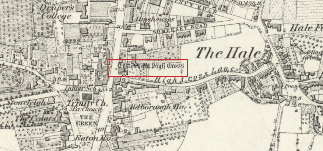
Cross shown on 1873 map

One of the earliest records of what was called the “hie crosse” is contained in a court-roll of 1456.  It was at that time a wooden wayside cross, but there are hints that its origins may go back to Roman times.  The Cross is next to what was the southern end of Ermine Street, built by the Romans where there was no pre-existing roadway and described as the most important thoroughfare in Britain: built to give direct communication to the main centres of the military occupation at Lincoln and York.  Writing of Roman land survey marks, the now discredited early 20th century Middlesex historian Sir Montagu Sharpe (1932) thought Tottenham Cross possibly marked an earlier (i.e. Roman) stone, although no archaeological evidence has been found to support this.  As it was next to Ermine Street it could equally have been a milestone or ceremonial pillar. After the Romans left it may have become a local heathen shrine which, with the coming of Christianity, was ultimately replaced by a wooden cross—but this is speculation, and we will probably never know why and when the original cross was placed where it was.

Originally in the historic County of Middlesex, the settlement of Tottenham surrounding the Cross was known from mediaeval times to the 19th century as ‘Tottenham High Cross’.  Local historian William Robinson writing prior to 1840 thus describes the Cross:

“About the year 1580, a column of wood was standing, with a square sheet of lead on the top to throw off the water, supported by four spurs: these, being decayed and rotten, were taken down, about the year 1600, by Dean Wood, Dean of Armagh, who at that time resided in a house on the east side of it, and who erected on its site an octangular brick column, pointed at the top and crowned with a weathercock, and the initials of the four cardinal points, and under the neckings, small crosses, which were called tau-crosses, according to the true cross or Greek letter T.

“Tottenham High Cross, as it appeared in 1788, was an octangular brick pillar, divided into four stories, viz.: a double plinth, first portion of the pillar; second portion, of the same; and a pinnacle; each plinth and story rendered distinct one from the other by certain appropriate mouldings ; and the whole design appeared without any kind of ornament, pointed at the top and crowned with a weathercock. The Cross having fallen into decay, several of the inhabitants of the parish entered into a subscription, in the year 1809, for the purpose of putting it into a proper state of repair, and about the sum of £300. was raised. It was accordingly repaired, and covered with Parker’s cement. The octangular plan, and the proportions of the Cross in its four stories, have not been departed from ; but in other respects it is a new work ; some of the decorations seem to be formed from the exterior and interior of the chapel of Henry VIII; the double plinths or pedestals are as plain as before, but the intermediate mouldings are new; the first portion of the pillar consists of angular pilasters at each cant done with a pointed head; compartment of five turns, connecting itself with another compartment; above it diamonded, with a shield containing an imitation of the black letter. As there are eight faces to the upright, of course there are as many shields, each bearing a letter of the same cutting, beginning at the west face, TOTENHAM: in consequence of there being but eight shields, one of the T’s in the spelling has been necessarily dispensed with. The mouldings between this story and the second are worked into an entablature, with modern fancy heads and small pieces of ornaments alternately set at each angle.

“Second story—small buttresses at the angles of the octagon, with breaks and pinnacles, but no bases. The face of each cant has a compartment embellished with an ogee head, backed with narrow pointed compartments. The mouldings between this story and the pinnacle, making out a fourth story, give, at each angle, crockets, and its termination is with a double finial, but not set out in geometrical rule to the crockets below : there is at the top a vane, with N. E. W. S. The base is surrounded with a neat iron railing on Portland stone curb. The date at which these alterations were made is not placed in any conspicuous part of the structure.”
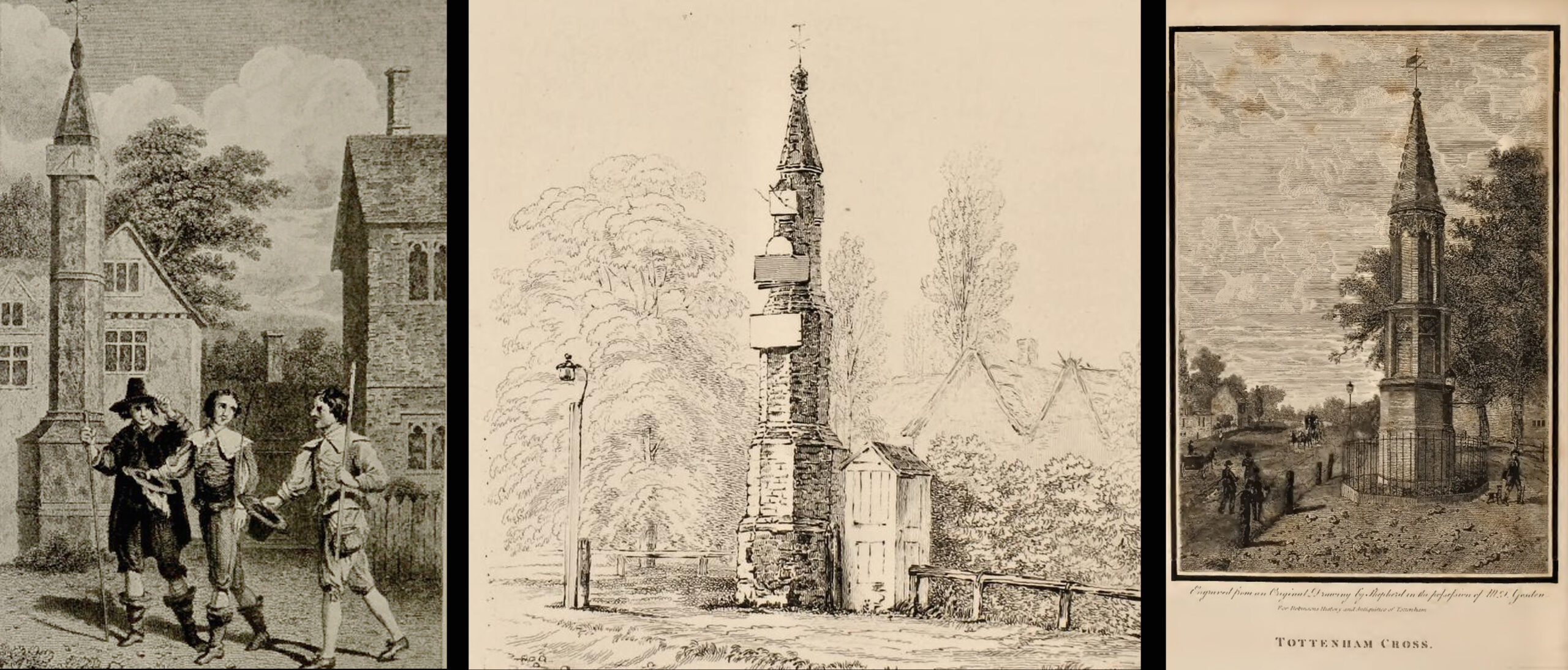
(left) engraving based on Samuel Wale’s 1759 illustration to Compleat Angler; (centre & right) 19th C views pre- and post-renovation

The craftsman who carried out the modernisation was a Mr. Bernasconia, working to the designs of a Mr. Shaw. Not everyone was pleased by the transformation. A regular contributor identified only as ‘An Architect’ made these caustic comments in the November 1809 edition of the Gentleman’s Magazine:

“Tottenham High Cross has this summer been covered over with Compo: it previously bore a simple appearance, but is now rendered of a very rich and elaborate cast, doing away in the first instance the Architectural history of the erection; and allowing it possible that there might once have been on the spot an Eleanora Cross, holding in contempt, by a want of due imitation, the characteristic style of decoration prevailed at at the time of the Queen’s demise.  But according to the system of our Professional innovators, to destroy a sacred relick of antiquity, and to restore it as it is called, upon a model quite in a different style and nature, is one and the same thing. “Any thing is Gothick.”

“….Surveyed November 1809. Entirely covered with the proclaimed everlasting stuff, Compo; a stuff now the rage for trowelling over our new buildings, either on the whole surface, or in partial daubings and patchings; it is used in common with stone work, for instance, on an arcade, half one material, half the other; “ making good,” as it is called (abominable expedient) the mutilated parts of Antient Structures, there sticking on until it reverts (after exposure to the air for three or four years, more or less) to its first quality, dirt and rubbish, and then is seen no more….

“Provided this Compo effort had been advanced on any other occasion, and on any other piece of ground, where no piece of Antiquity was to become the spoil, such as an object to mark the centrical point of three or four counties, a general standard of miles or any other common document for the information or amusement of travellers, all would have been well, and some praise might have been bestowed, for its tolerable adherence to the above style, if not for the material wherewith it is made up. But as nothing of this sort will come in aid of the innovators, and only the barefaced presumption, “ alter or destroy, what was,” is to be encountered, let the detail of parts, put this matter to issue….”

Folklore
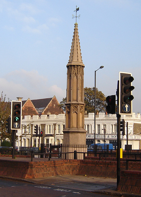
A modern view (Wikipedia Creative Commons)

The Cross stood in front of the Swan Inn, a place frequented by fishing writer Izaak Walton in the 1640s when he would go to fish in the nearby River Lea.  In 1653 he published The Compleat Angler describing his fishing activities in the classical form of a philosophical dialogue between him as ‘Piscator’ and ‘Venator’ (hunter) and other passing characters, starting and ending his adventures at the High Cross.  The 1759 edition of Compleat Angler contains the earliest illustrations of the Cross, with some slight artistic licence, by Samuel Wale.

Afterword

As the Cross now stands in the maelstrom of North London’s traffic, it is worth recalling American traveller Nathaniel Carter’s 1825 observation when travelling north from London:

“Passing Tottenham Cross, we entered a rich agricultural country, possessing the usual charms of English landscape.”

References

  1. An Architect (pseud.) – Architectural Innovation No. CXXXIX – The Gentleman’s Magazine, November 1809
  2. Anonymous – Tottenham High Cross, The Gentleman’s Magazine, April 1820
  3. Blair, John, The Church in Anglo Saxon Society, Oxford University Press 2005
  4. Carter, Nathaniel Hazeltine, Letters From Europe..in 1825 ’26 & ’27, G & C & H Carvill, New York, 1829
  5. Margary, Ivan D., Roman Roads in Britain, 3rd Ed., John Baker: London 1973.
  6. Robinson, William, The History & Antiquities of the Parish of Tottenham, 2nd Ed., Nicholls & Son, W. Pickering, W.B. Hunnings: London 1840.
  7. Sharpe, Montagu, Middlesex in British, Roman & Saxon Times, 2nd Ed., Methuen: London 1932.
  8. Walton, Izaak, The Compleat Angler, Facsimile of the 1st Ed., containing illustrations from the 2nd US edition by John Major, No imprimatur, 1907.

© Paul T Hornby 2020
River Avon Stone, Bulford, Wiltshire

Standing Stone (lost):  OS Grid Reference – SU 161 432

Archaeology & History

In William Stukeley’s Stonehenge, he described a number of monoliths outlying Salisbury Plain that also possessed a prehistoric pedigree.  Most of them have been recorded, but this one seems to have been forgotten about — perhaps by virtue of it having fallen into the River Avon!  Edgar Barclay (1895) described it in his fine survey, saying:

“In the bend of the river below the village, is a large submerged stone; only during drought is any portion of it visible above water; it can, however, in ordinary times, be dimly seen from the bank, which is of chalk, here very steep and overgrown.  The country people assert that a metal ring, “turning always,” is let into its upper end.  Legend relates that when the Devil brought the rocks of Stonehenge from Ireland, tied together with withes, this stone escaped from the bundle and fell into the river.  Its position forbids the belief that it got fixed in the bed of the stream when its passage to Stonehenge was being attempted, for it lies immediately beneath the crest of a very steep bank, and at its most inaccessible point; as the stream sweeps against this, the water must always have been deep at this spot, the open valley would everywhere offer more favourable points for such an operation, especially would this be the case before the Avon was dyked.  A boundary stone would have been placed on the brow of the hill; if the stone be a grey-wether, as report says, and as is probable, it may originally have stood on the bank, and “once upon a time”, a ring having been fixed in it, it may have been dragged into the stream to moor a ferry-boat.  It lies closely midway between the stone on Bulford Down and that in Durrington fields.”

One wonders if any local people might know more about this…

References:

  1. Barclay, Edgar, Stonehenge and its Earth-works, D. Nutt: London 1895.

© Paul BennettThe Northern Antiquarian

Dawe’s Cross, Cambridge, Cambridgeshire

Cross (destroyed):  OS Grid Reference – TL 455 578

Archaeology & History

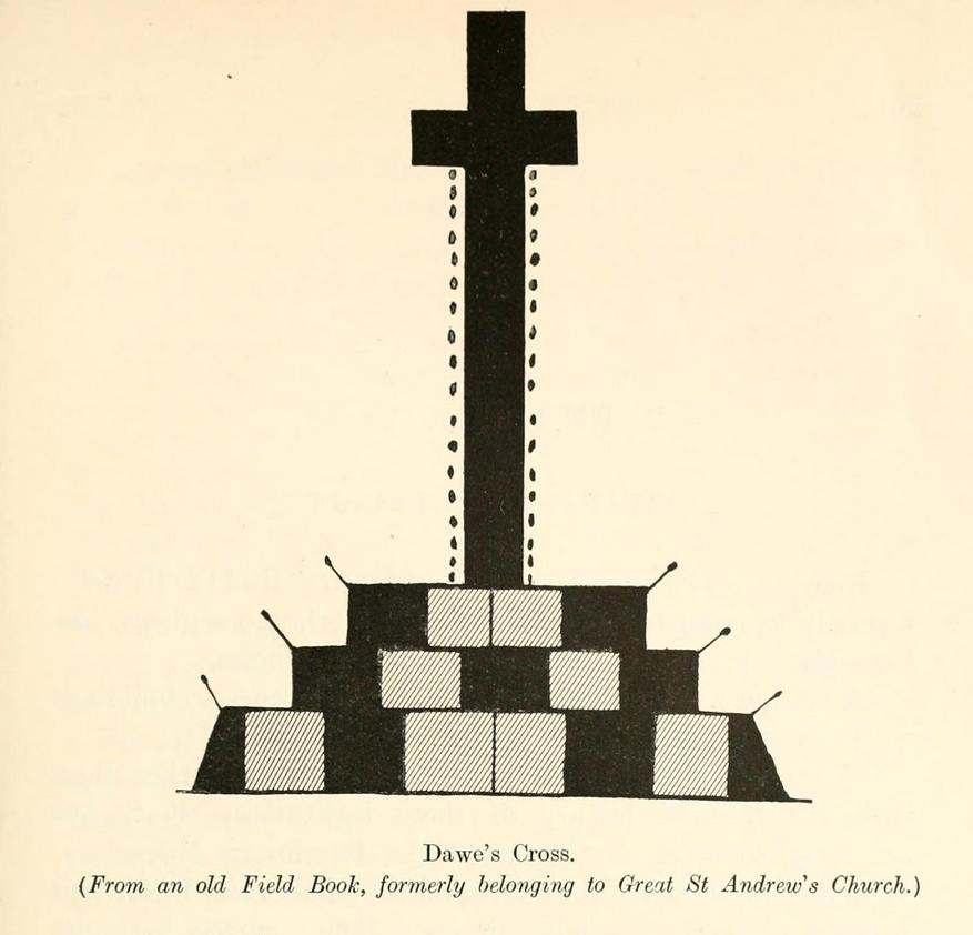
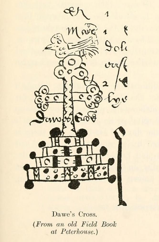
This is one of several medieval stone crosses in Cambridge that were destroyed several centuries ago.  This particular one was erected on a three-stepped stone base at the old crossroads where, today, the modern A1307 of Regent Street meets the A603 Lensfield Road.  It was described in an old Field Book of 1575 as standing being beside an old poplar tree, long gone.  Mr H.P. Stokes (1915) gave us a short account of the site, telling:

“In describing the lane called “Deepway” between the London Road and the Hadstock Way and known as “King’s Lane” from the latter road to Hinton Way, mention was made of a Cross (called Dawe’s Cross) which stood at what is now known as Hyde Park Corner.  Dawe’s Cross is often mentioned in ancient deeds, and in an old Field Book, which formerly belonged to the vestry of the Church of St Andrew the Great, there was a most interesting representation of it.  This is here reproduced…from a copy in the celebrated Bowtell MSS.”

The cross stood along one of Alfred Watkins’ (1932) “archaic tracks”, or leys, in this area—although he wasn’t aware of its existence.

References:

  1. Stokes, H.P., Outside the Barnwell Gate, Cambridge Antiquarian Society 1915.
  2. Watkins, Alfred, Archaic Tracks round Cambridge, Simpkin Marshall: London 1932.

© Paul BennettThe Northern Antiquarian

Two Captains, Stetchworth, Cambridgeshire

Tumuli (destroyed):  OS Grid Reference – TL 6246 6048

Also Known as:

  1. Two Howes

Archaeology & History

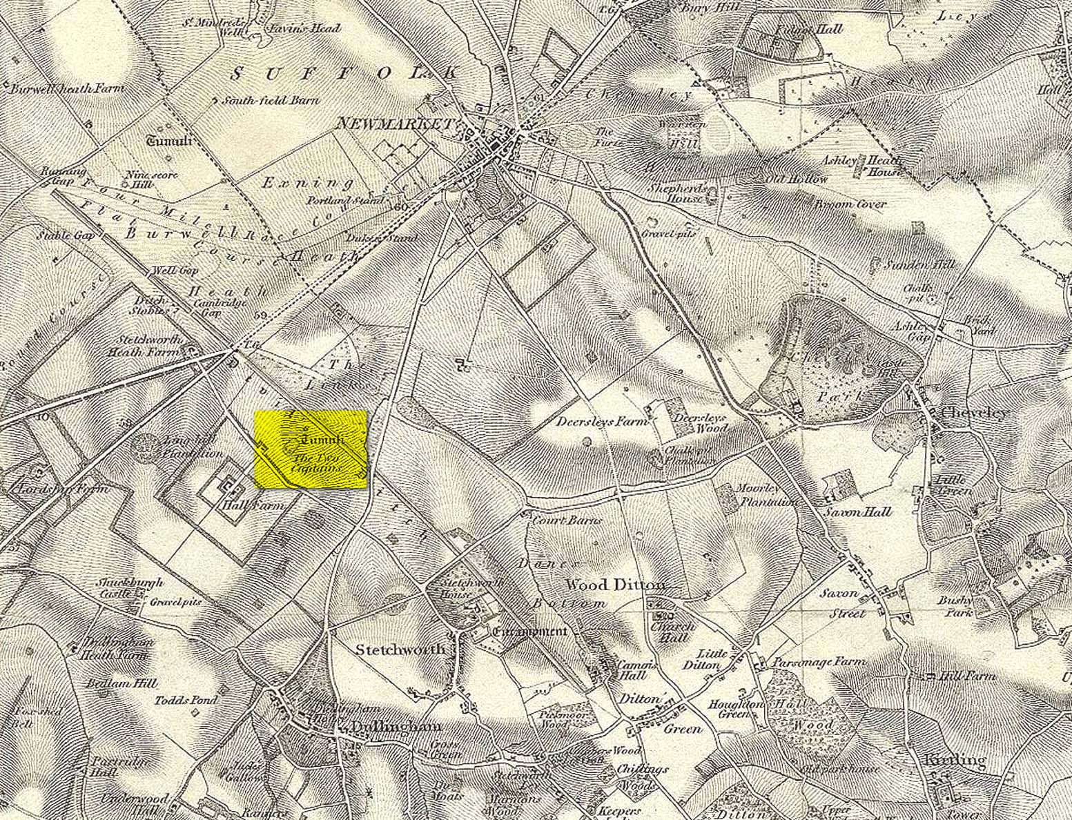
Mentioned as early as the 15th century in the Ely Cartulary as the “Tuomhowe,” or “two hills”, the place-name authority P.H. Reaney (1945) identifies this with the two “barrows” which our early cartographers map as our ‘Two Captains’.

Site shown on 1834 map
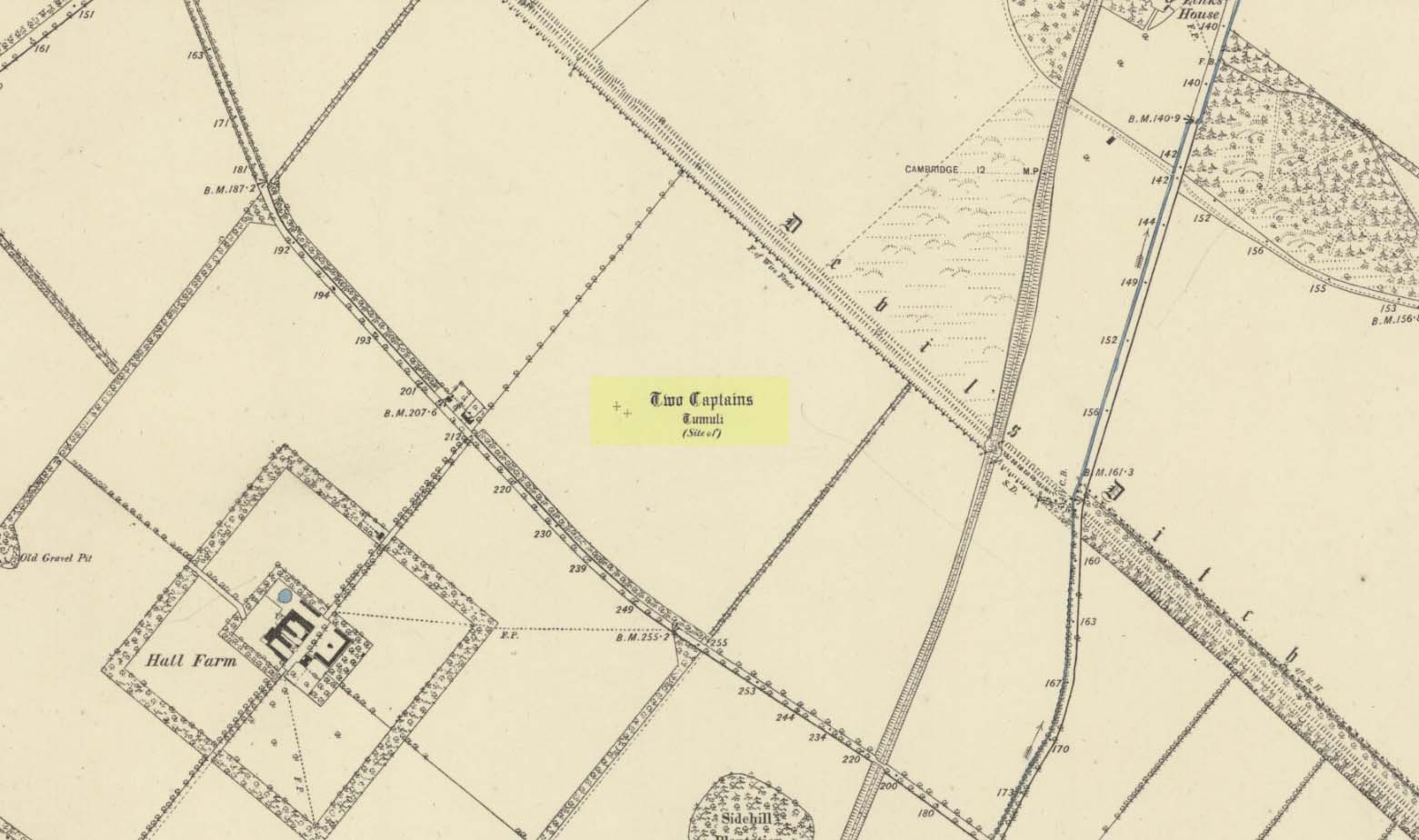
Site of the Two Captains on the 1885 OS map

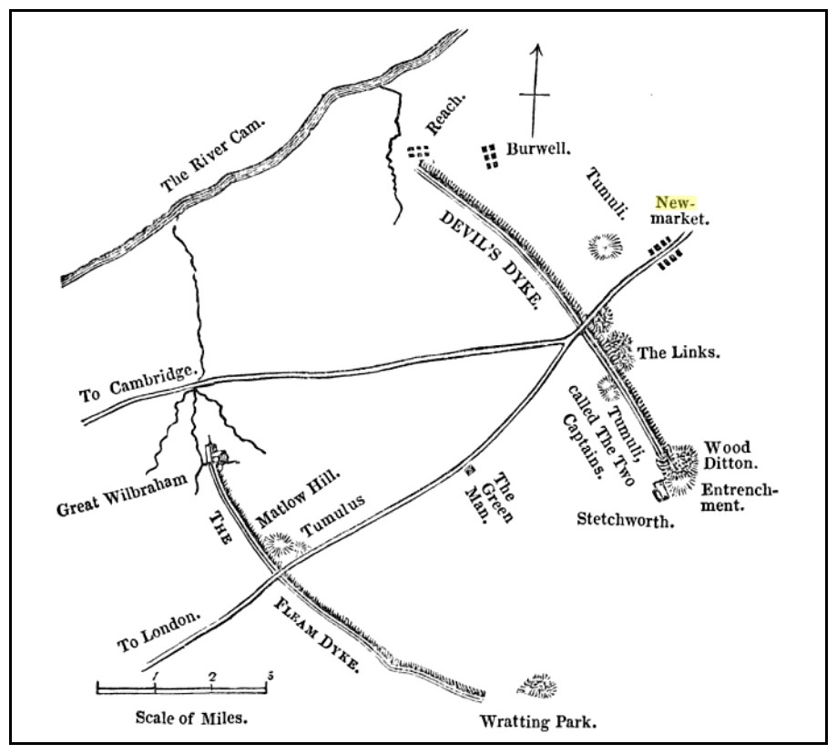
In the 1834 survey by the Ordnance Survey lads, these conspicuous burial mounds were clearly marked on the west side of the Devil’s Dyke, less than 2 miles south of the Newmarket Necropolis.  They were seen first-hand by a number of local walkers, including A.J. King (1845) in his account of the aforementioned dyke.  But on the 1885 OS map, the old tombs had apparently gone.  Evidently some local knob-head had come along and took it upon himself to destroy these two burial mounds, which had lived here for thousands of years.  However, despite the OS-maps indicating that it had been totally destroyed in the 1880s, a couple of later writers said that faint traces were still visible, including the historian Charles Harper. (1904)  When he came here, he told how

“Little is now left of this once prominent mound, once important enough to be marked on Ordnance maps, but now ploughed nearly flat.  It stands in the third field from the road, on the right hand, a field now under corn, but until forty years ago a wood.”

A.J. King’s 1845 map

Very little is known about the place and even the late great barrow fetishist, L.V. Grinsell (1936) could dig nothing out, despite the two tombs mentioned in passing by a number of writers.

Folklore

In Grinsell’s (1976) book on the folklore of ancient sites, he drops the Two Captains into a simple category of them relating to some battle, without any information.  But it seems there isn’t much to go on.  The local history work of Charles Harper (1904) intimates the same thing, bringing attention to the folklore of the adjacent Devil’s Dyke, as

“it is one of the many sites identified as the scene of Boadicea’s defeat by Suetonius Paulinus, but we are sceptical of this particular one, although the ancient tumulus on the outer face of the Ditch, still called the Two Captains, points to some forgotten conflict in which two leaders were slain and buried on the contested field.”

References:

  1. Gomme, G.L., The Gentleman’s Library: Archaeology – volume 2, Elliot Stock: London 1886.
  2. Grinsell, Leslie V., The Ancient Burial Mounds of England, Methuen: London 1936.
  3. Grinsell, Leslie, Folklore of Prehistoric Sites in Britain, David & Charles: Newton Abbot 1976.
  4. Harper, Charles G., The Newmarket, Bury, Thetford and Cromer Road, Chapman & Hall: London 1904.
  5. King, A.J., “The Devil’s Dyke, Newmarket,” in The Gentleman’s Magazine, January 1845.
  6. Reaney, P.H., The Place-Names of Cambridgeshire and the Isle of Ely, Cambridge University Press 1943.
  7. Royal Commission Ancient Historical Monuments, Inventory of Historical Monuments in the County of Cambridgeshire – Volume 2: North-East Cambridgeshire, HMSO: London 1972.
  8. Tymms, S., “The Devil’s Dyke, Newmarket” in Proceedings Suffolk Inst. Archaeology. 1, 1849-53 168-70

© Paul BennettThe Northern Antiquarian


Newmarket Heath (3), Newmarket, Suffolk

Tumulus (destroyed):  OS Grid Reference – TL 6122 6358

Archaeology & History

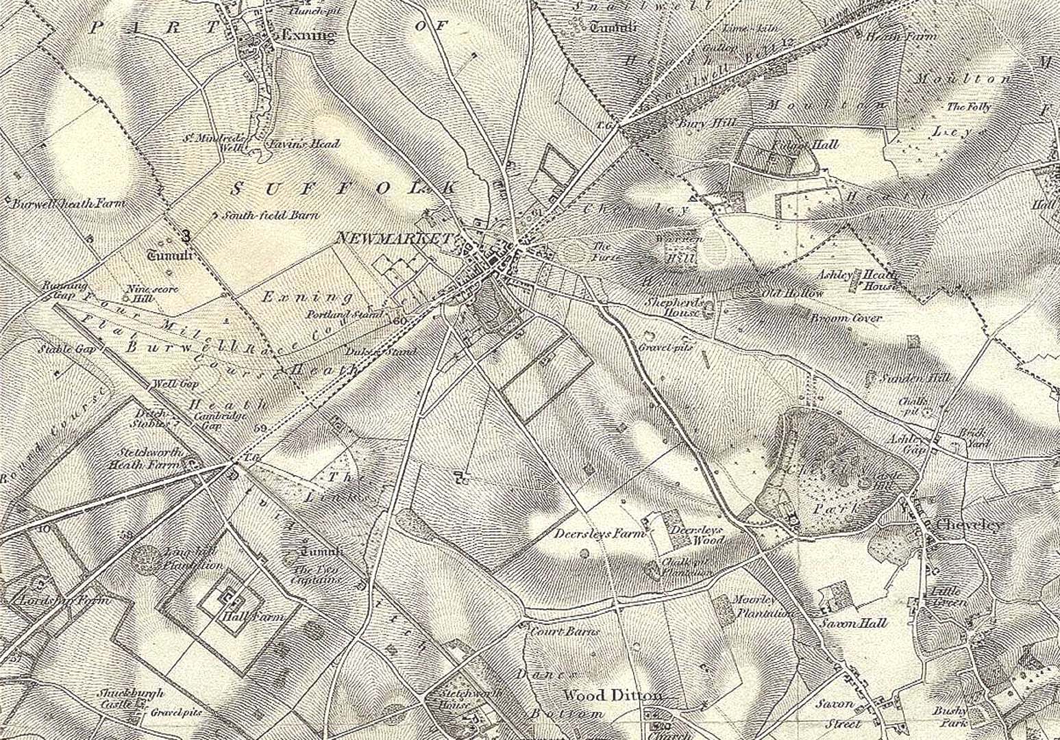
Tumulus ‘3’ on 1834 map

This is one of at least five prehistoric tombs that were known to have existed in and around the Newmarket race-course—all long gone.  It stood some 50-60 yards northeast of the Newmarket Heath (2) tumulus and was one in the cluster highlighted as ‘tumuli’ on the 1834 OS-map (right).  Despite its destruction sometime in 1883, a scar of the monument was seen from the air in the 1940s by J.K.S. St Joseph as a ploughed-out ring ditch, showing it to have been some seventy feet across.  Sadly, no ground trace of the monument exists.

References:

  1. Fox, Cyril, The Archaeology of the Cambridge Region, Cambridge University Press 1923.
  2. Royal Commission Ancient Historical Monuments, Inventory of Historical Monuments in the County of Cambridgeshire – Volume 2: North-East Cambridgeshire, HMSO: London 1972.

© Paul BennettThe Northern Antiquarian


Newmarket Heath (2), Newmarket, Suffolk

Tumulus (destroyed):  OS Grid Reference – TL 6116 6352

Archaeology & History 

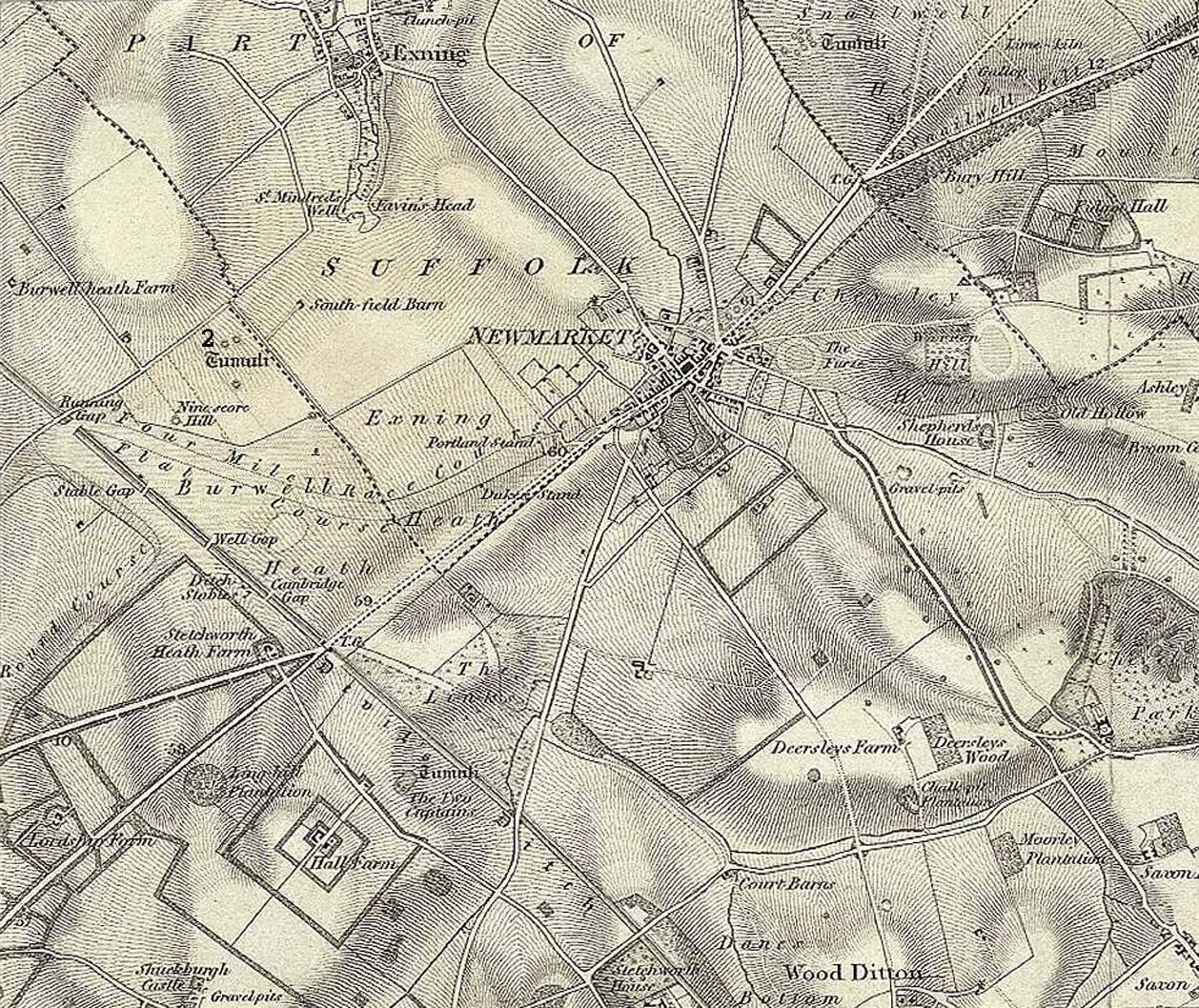
Tumulus 2, centre-left

This is one of at least five prehistoric tombs that were known to have existed in and around the Newmarket race-course.  Found some 600 yards NNE of the Ninescore Hill tumulus, and some 40 yards from its nearest companion, it was shown as one in a group of ‘Tumuli’ on the 1834 OS-map (right) but, along with the rest, was subsequently destroyed sometime around 1883.  A landscape scar of the monument was seen from the air in the 1940s by J.K.S. St Joseph as a ploughed-out ring ditch some 75 feet across.  This was reported as still visible by the Royal Commission doods in the 1970s, but no ground trace whatsoever exists.

References:

  1. Fox, Cyril, The Archaeology of the Cambridge Region, Cambridge University Press 1923.
  2. Royal Commission Ancient Historical Monuments, Inventory of Historical Monuments in the County of Cambridgeshire – Volume 2: North-East Cambridgeshire, HMSO: London 1972.

© Paul BennettThe Northern Antiquarian


Newmarket Heath (5), Swaffam Prior, Cambridgeshire

Tumulus (destroyed):  OS Grid Reference – TL 60 62

Archaeology & History

This is one of many long lost prehistoric tombs that were known to have existed in and around the Newmarket race-course, but unlike the Newmarket tumuli 1 – 4 which were all on the first OS-map of the area, this one had been destroyed before the Ordnance Survey lads came here.  As a result we don’t know its exact whereabouts.

Described in both the Cambridge Chronicle and Gentleman’s Magazine in 1827, the accounts even then were talking about it in the past tense, albeit pretty recently.   The race-course at Newmarket was being modified, leading to the destruction of our ancient landscape—and with it, this tumulus.  In those days however, such destruction was deemed as an ‘improvement’, as Sylvanus Urban (1827) tells at the start of his account:

“The improvements making in the exercise ground at Newmarket, Cambridgeshire, have led to some discoveries which may, perhaps, tend to the elucidation of the hitherto obscure origin of the entrenchment commonly called “The Devil’s Ditch.”  In removing one of the monumental remains denominated barrows, or tumuli, which are numerous in this neighbourhood, the skeleton of a person was found deposited near the surface, whose remains were too recent to be associated with the area of its place of interment; but, upon clearing away the earth to the centre of the mound, a discovery was made of an urn, of rude construction and materials, containing ashes, together with some beads, which, it is presumed, formed the ornaments of the person to whose honour the barrow was dedicated.  There were also found two coins, supposed to be Roman, and a fragment of a cup, of far superior manufacture to the urn, lying promiscuously at the depth of about two feet.”

A summary of this was included in Babbington’s (1883) archaeological survey.  But in Cyril Fox’s (1932) list of barrows near Cambridge he seemed to confuse this “tumulus on Exercise Ground” (no.16) with what he thought was another tumulus (no.17), which he described as, “Exact site unknown. Contained a cremation interment. Burnt bones and sherds of Bronze Age type, also Roman sherds.” The two are the same thing.

References:

  1. Babbington, Charles C., Ancient Cambridgeshire, Cambridge Antiquarian Society 1883.
  2. Fox, Cyril, The Archaeology of the Cambridge Region, Cambridge University Press 1923.
  3. Royal Commission Ancient Historical Monuments, Inventory of Historical Monuments in the County of Cambridgeshire – Volume 2: North-East Cambridgeshire, HMSO: London 1972.
  4. Urban, Sylvanus, “Domestic Occurrences,” in Gentleman’s Magazine, September 1827.

© Paul BennettThe Northern Antiquarian


Newmarket Heath (4), Newmarket, Suffolk

Tumulus (destroyed):  OS Grid Reference – TL 613 633

Archaeology & History

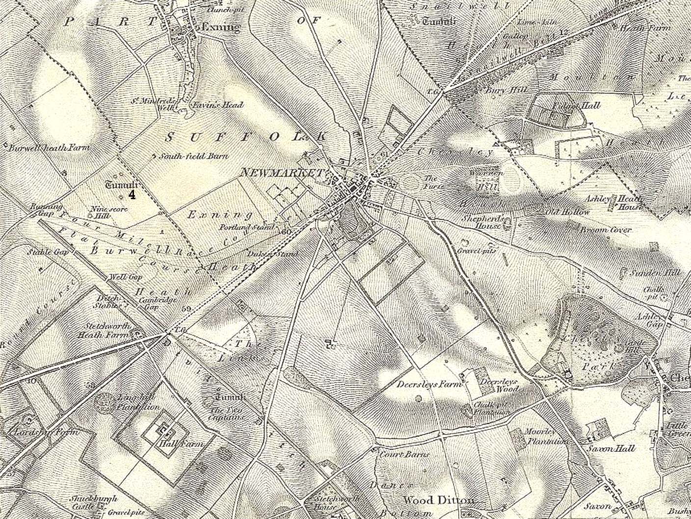
Tumulus 4, centre-left

This is one of at least five prehistoric tombs that were known to have existed in and around the Newmarket race-course.  It could be seen five-hundred-and-odd yards northeast of the Ninescore Hill tumulus and about 280 yards southeast of its Newmarket Heath 2 companion. The site was shown as one of the “tumuli” on the 1834 OS-map (right) but, along with its friends, was destroyed sometime around 1883.  Unlike its companions, no scar of its remains are visible from the air so we don’t know how big it was, but I’d assume the olde fella to be of a similar size and style to its close neighbours.

References:

  1. Fox, Cyril, The Archaeology of the Cambridge Region, Cambridge University Press 1923.
  2. Royal Commission Ancient Historical Monuments, Inventory of Historical Monuments in the County of Cambridgeshire – Volume 2: North-East Cambridgeshire, HMSO: London 1972.

© Paul BennettThe Northern Antiquarian


Ninescore Hill, Newmarket, Suffolk

Tumulus (destroyed):  OS Grid Reference – TL 6091 6304

Also Known as:

  1. Newmarket Heath 1
  2. Ninescore Hill Barrow

Archaeology & History

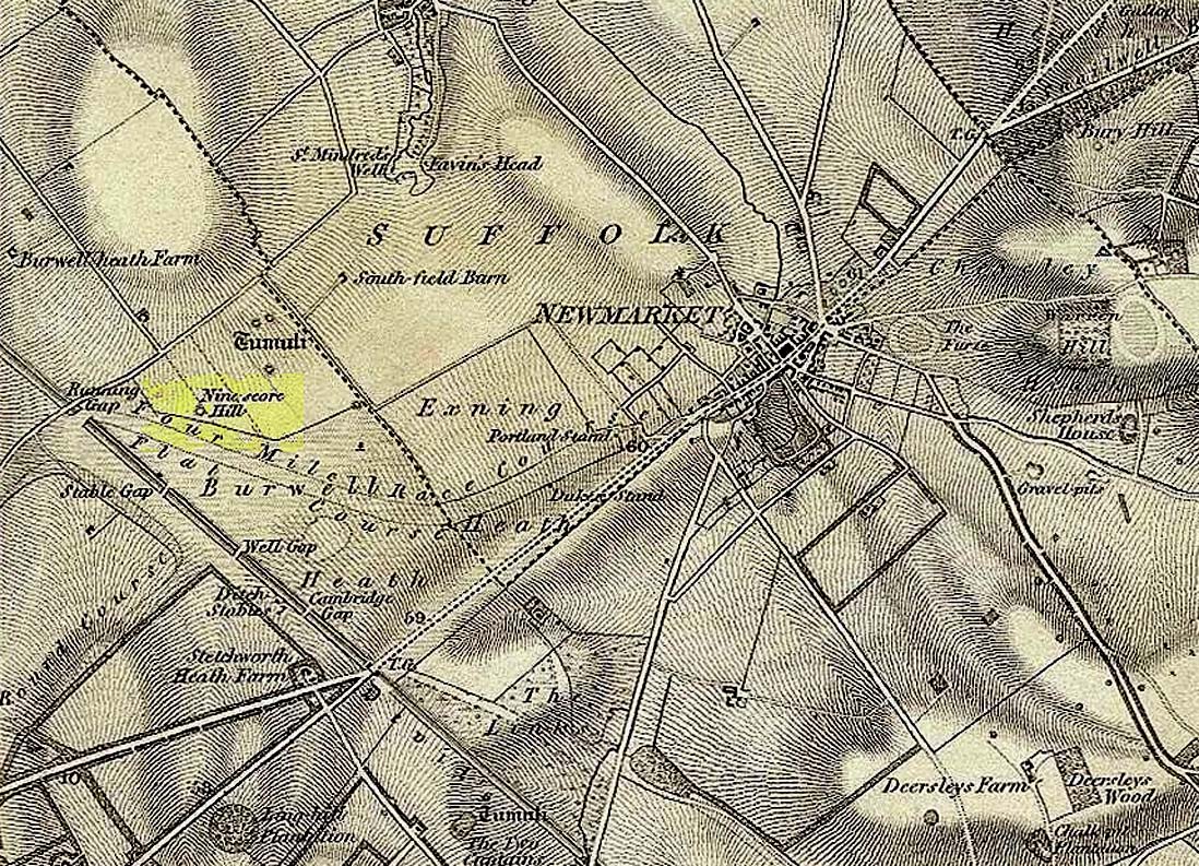
Ninescore Hill on 1834 map

Upon the small and curiously-named Ninescore Hill on the edge of Newmarket’s race-course, the old-school archaeologist Cyril  Fox (1923) told that “800 yards due east of Running Gap”, was a prehistoric burial mound that was destroyed in 1885.  Highlighted on the 1834 OS-map, a 19th century excavation found that the tomb “contained two inhumation interments associated with beakers,” along with some “flint arrowheads, and a secondary interment, probably Saxon.” In more recent times, the doods from the Royal Commission (1972) added the site to their inventory and noted that a faint outline—known as as ring ditch—is visible from the air when conditions are just right.  But there’s bugger all left of it at ground level.

References:

  1. Fox, Cyril, The Archaeology of the Cambridge Region, Cambridge University Press 1923.
  2. Royal Commission Ancient Historical Monuments, Inventory of Historical Monuments in the County of Cambridgeshire – Volume 2: North-East Cambridgeshire, HMSO: London 1972.

© Paul BennettThe Northern Antiquarian

Robin Hood’s Oak, Great Horkesley, Essex

Legendary Tree (lost):  OS Grid Reference –TL 96 28

Archaeology & History

In more than twenty volumes about Robin Hood in the Northern Antiquarian library, no mention can be found of this all-but-forgotten site, first recorded (I think) in September 1637, in the boundary perambulation account of northern Colchester.  In days of olde, folk walked the boundaries annually and so the description given here follows their very footsteps – although the landscape has obviously been altered in places since then.  Because of the length of the entire perambulation their account is rather long, so I’ve cut to the piece relating to our legendary oak tree, which gives a good idea of its location.  We meet up with them at a place called Motts-Bridge, just above a place that is today called Seven Arches Farm (TL 9630 2595):

“…and so over Mott’s-bridge, and so cross the river by Nicholas Ayleward’s howse into the meadowe crossinge over to the lower ende of West-fielde, and from thence to Buttolph’s brooke leavinge the Brooke alwais upon the left-hand, and so along to Thomas Abrige (which is righte against Robin Hood’s oake). And from thence to Black-brooke under Chesterwelle and so along the Rampiers by Horkesley Heathe to the brooke that is under Langham-park-corner…”

P.H. Reaney (1935) proposes that the ‘Rampiers’ in this account is the Iron Age hillfort of Pitchbury Ramparts.

The description of its whereabouts isn’t too clear, but in a subsequent and much longer perambulation account from August 1671, some extra topographical features are mentioned.  Starting not far from Mott’s Bridge, down Shett’s Hill to Newbridge,

“and then into the Fields in the occupation of Matth. Ayleward…through a gate a little above the Bridg: and soe along to Matth. Ayleward’s Yard, crosse the River into Matth. Ayleward’s Meadowe, and crosse that Meadowe into the lower part of Westfields, neare to which is a Foote-bridge cross the river, which is called Mott’s-bridge.  And soe along through West-fields to a Gate in a lane at or neere the north ende of a Meadow of one Mrs —, now in Samuel Duglet’s occupation, which lane parts West-fields from Bergholt, as the Parsons of each Parish, whoe were both present, affirmed; and, upon a Tree standing neere to which Gate is set a crosse.  And from thence to Butolph’s brooke, leaveing the brooke allwaies  upon the left-hand; and soe along through Mr Leming’s Meadows and Woods at the ende of them to a Bridge called Thomas Abridge, leading on to Horkesley Heath, which bridge is right against Robin Hood’s Oake, that stood on the pitch of the hill. And from thence along the Naylande Roade over Horkesley-heathe to Blackbrooke under Chesterwell, which Brooke runnes crosse the way at the foote of Horkesly cawsy…”

This second account seems to speak of the tree in the past tense, telling us that “Robin Hood’s Oake, that stood on the pitch of the hill”, but we can’t be completely sure.  I presume that there’s no longer any trace of this legendary oak tree; however, considering the fact that oaks can live to an incredible age, it may be worthwhile for a local antiquarian to follow this ancient boundary and see if, perchance, any remaining tree stump might still be there.  Y’ just never know…..

There are several other place-names in Essex relating to our mythical outlaw, including Robinhood End at Finchingfield described in 1699, and a farm of the same name nearby; plus a Robin Hood’s Inn near Loughton. (Reaney 1935)  There are probably a few more hiding away in field-name records…

NB:  The grid-reference map linked to this site is an approximation.  If someone can find the exact spot where the tree stood, we’ll update its position.   

References:

  1. Morant, Philip, The History and Antiquities of the Most Ancient Town and Borough of Colchester, W. Bowyer: London 1748.
  2. Reaney, P.H., The Place-Names of Essex, Cambridge University Press 1935.

© Paul BennettThe Northern Antiquarian