‘Standing Stone’: OS Grid Reference – SS 8896 3355
Getting Here
You can’t really miss this. Take the road south from Winsford, up the steep hill onto the moors and before you reach the crossroads, look up across the slope on your left where you’ll see a small building on its own. Go there!
Archaeology & History
A curious upright monolith more than five feet long (though some of this is embedded in the ground) with the words ‘CARAACI NEPVS’ carved on one side, is strangely closetted in a silly ‘house’ of its own on the moortops! But the origins and history of the stone are contentious. Some proclaim it as prehistoric, others Romano-British, and others as being from the Dark Ages. In the 1960s and ’70s, archaeological tradition had its origins in the Romano-British period, and certainly the carved lettering on the sides of the stone seem to indicate a Roman provenance; but as the great Exmoor historian S.H. Burton (1974) told,
“It is possible that the stone was erected hundreds of years before it was inscribed, and the existence of an ancient trackway alongside, leading to the Barle, strengthens this possibility. But, like most things about the Caratacus Stone, this is guesswork.”
We know it stood here in the 13th century as it was described in perambulation records of 1219 and 1279 AD; but it’s more than likely to be a monolith erected in the Dark Ages. Grinsell (1970) however is a little more cautious, telling:
“The likelihood of the person in whose memeory this stone was raised claiming kinship with the Caratacus who was the arch-enemy of Rome, c. AD 45-50, has on more than one occasion been questioned. It is, however, too tempting to be abandoned by the present writer.”
The carving on the stone was deciphered by the legendary Prof. John Rhys at the end of the 1800s, telling it to have been Carataci Nepos, the Kinsman of Caratacus (and variants thereof), who held out against the Romans in south Wales until AD 50. The old Celtic writer, R.A.S. Macalister, thought the stone to have been dedicated to a local christian hero, St. Carantoc, but this notion has been generally dismissed.
Folklore
The old stone is said to be a site where buried treasure exists — though none has ever been found. There is also an old tradition that “ghostly horses and waggons rumble towards the stone at midnight” — but this as likely relates to its proximity with the old crossroads a short distance away.
References:
Burton, S.H., Exmoor, Hale: London 1974.
Grinsell, L.V., The Archaeology of Exmoor, David & Charles: Newton Abbot 1970.
Page, John Lloyd Warden, An Exploration of Exmoor and the Hill Country of West Somerset, Seeley 1890.
Vowles, Alfred, History of the Caratacus Stone, privately printed 1939.
Sonning Cursus & other ancient remains (after Ford 1987)
Barely visible nowadays, the site was described by archaeologist Steve Ford (1987) as, “a very convincing cropmark with markedly rectangular end with entrance gap” at its far eastern end. This once impressive looking cursus aligns east-west and is found amidst a cluster of other neolithic and Bronze Age monuments.
It was first discovered by aerial surveying in 1959, but still remains unexcavated (I think!). The dead straight neolithic monument,
“consists of parallel ditches 45 metres apart extending for at least 200m west towards lower ground. The eastern end has a (flattened) terminal with a single entrance, whereas the western end is untraceable beyond a modern field boundary.”
In Roy Loveday’s (2006) survey, this cursus was stated as measuring 250m in length and 35m across. Although the western end hasn’t been located, it’s highly probable that it reached to the River Thames a short distance away. An excavation at one of the three ‘enclosures’ beyond the eastern end of this monument, revealed it have been built in the late neolithic period.
References:
Ford, Steve, East Berkshire Archaeological Survey, Berkshire County Council 1987.
Loveday, Roy, Inscribed across the Landscape, Tempus: Stroud 2006.
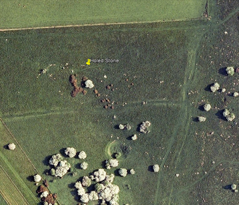
Follow the same directions as if you’re visiting the Polisher Stone at the top-end of Overton Down where it meets Fyfield Down. From here, walk down the slope for a hundred yards or so where you’ll notice, just above the long grassy level, a line of ancient walling running nearly east to west. It’s very close to the yellow marker in the attached aerial image shot to the right. If you walk along this line of walling you’ll find what you’re looking for.
Archaeology & History
Overton’s Holed Stone
As I’ve only been here once, and briefly — under the guidance of the Avebury expert Pete Glastonbury — my bearings on this site may need revising. There are two distinct sections of walling here: one has been excavated by Peter Fowler and his team; the other hasn’t. (correct me if I’m wrong Pete) And in Fowler’s (2000) fine survey of this area he does not describe this very distinct holed-stone in the line of walling, or adjacent “linear ditch F4”, as it was called. But then, many archaeologists don’t tend to find items such as these of any interest (unless their education stretches to other arenas, which isn’t usually the case). But the stone seems to be in a section of walling that isn’t in their survey; standing out in aerial imagery as a less well-defined, but still obvious line of walling that is closer to the fence, 70-80 yards north, with a decidedly Iron-Age look about it!
But, precision aside! — as you can see in the photos, the holed stone here isn’t very tall — less than 2 feet high; though we don’t know how deep the stone is set into the ground. This spot is on my “must visit again” list for the next time we’re down here!
There’s nowt specific to this stone, nor line of walling, nor settlement (as far as I know), but it seems right to mention the fact that in British and European folklore and peasant traditions, that holed stones just like the one found here have always been imbued with aspects of fertility — for obvious reasons. Others like this have also acquired portentous abilities; whilst others have become places where deeds and bonds were struck, with the stone playing ‘witness’ to promises made.
References:
Fowler, Peter, Landscape Plotted and Pierced: Landscape History and Local Archaeology in Fyfield and Overton, Wiltshire, Society of Antiquaries: London 2000.
We were graciously guided to this spot by local archaeological authority, Pete Glastonbury — which is good, cos otherwise it’d have probably taken us all day to find the damn thing! Best way to get here is out of the Avebury circle, east, up for about a mile up the Herepath or Green Street till you hit the ancient track of the Ridgeway. Turn left and walk up the gentle slope for another 350 yards or so, then note the footpath on your right. Go down the slope for about 150 yards, keeping your eyes peeled for the smooth rock with the slits in it, not far from the Holed Stone!
Archaeology & History
Although classified on the Wiltshire Sites & Monuments Record as an “unclassified feature,” this is one of a number of whetstones (as we call ’em up North) that feature in various settings in and around the Avebury region: literally, a rock used for sharpening axes, daggers and other metallic artifacts. First rediscovered in the spring of 1963 by a Mr Inigo Jones when he was out exploring the many rocks hereby for rare lichens and any more cup-markings like the one at nearby Fyfield Down, the site we see today is merely a long piece of stone with five or six long lines or grooves cut into the top-end, along which the ancient weapons and tools slid and cut into the rock, sharpening them.
It was thought until recently that this was the prime function of this stone; but following excavation work done here by Pete Fowler and his team in 1963, it seems that the stone actually stood upright! Digs were made on three sides of the stone and some earlier disturbance seemed apparent:
“The material appeared to be redeposited on top of an earlier ground surface, inferentially of medieval or earlier date. At the north end of the sarsen bench, the lip of a pit or trench was partly excavated. It showed clearly in plan as a feature dug into the top of an undated surface level with the disturbed top of the clay-with-flints; it was filled with flinty, clayey humus similar to that through which it was cut. In the top of that fill was a heavily weathered sarsen, c 0.6m by 0.45m, and a cluster of smaller, broken sarsen stones. The hole was at least 0.45m deep, its bottom as excavated marked by an increase in the density of flints. The evidence, though incomplete, suggested very strongly that the feature was part of a hole dug to take the pollisoir as an upright stone.” (my italics, Ed)
In the same dig, a medieval coin of King John (1199-1216) and the remains of a medieval horseshoe were found beneath the stone, giving Fowler and his team the notion that the stone had been split and pushed over at this period. Consistent evidence of activity from the neolithic period onwards was expected and found here.
In Lacaille’s (1963) original description of the site, he gave a most accurate description of the dimensions of the stone and its incisions. Highlighting its proximity to a cluster of other stones, as well as being close to a wide ditch, Lacaille’s measurements were thus:
“From 1ft (0.31m) above ground at its south end the regular surface of the sarsen slopes to the grass, its main axis being aligned about 15° west of the true north and south line. In length the stone measures 5ft 6in (1.68m) above the grass, and 2ft 10in (0.86m) in width.
“Closely grouped in the south-eastern corner of the sarsen there are six hollows. In plan the largest and southernmost is of long elliptical shape, 1ft 8in (0.5m) long and 9in (0.23m) at widest and 1in (0.0254m) deep. From its wider end near the eastern long margin there protrudes a short groove. Beside this, and curving slightly inward, there is another groove, 1¼in (0.028m) wide and ½in (0.013m) deep. It is as long as the large basin-like cavity. Next to it there runs one of similar length and width, but of only half the depth. In turn, a third groove, ½in (0.013m) wide, 1ft 8in (0.5m) long, has been worn at right angles to the long edge but to a much deeper hollow than its companions. At 2in (o.051m) to the north a lesser version of the main basin occurs. Like this it measures 1ft 8in (0.5m) in length, but is only 2¼in (0.058m) wide and ¾in (0.016m) deep. Vague in places over its interior length of 10in (0.25m), but attaining a maximum width of 1¼in (0.028m), a last hollowing shows faintly at both ends and nowhere deeper than 1/8in (0.0032m).”
The Polisher & its marksCeloria & Lacaille’s 1963 drawing of the stone
It appears that this fallen standing stone was being used to sharpen knives and axes whilst it stood upright and, in all probability, as a result of this ability would have been possessed of magickal properties to our ancestors. Metalwork was an important province of shamanism and smiths, whose practices were deeply enmeshed in the very creation of mythical cosmologies. Hence, the simple act nowadays of sharpening metal tools onto rocks would not have been a mere profanity to the people who came and used this stone to re-empower their weapons, but would have been entwined within a magickal cosmology. The spirit inherent in this stone would likely have been named and recognised. Today it is forgotten…
It also seems that this standing stone was part of some ancient walling. Aerial views clearly show it along the line of some sort of enclosure that runs down the slope, along the bottom and back up and around. In the same stretch of this enclosure walling we find the Holed Stone a little further down the slope. And holed stones, as any student of folklore and occult history will tell you, have long-established magickal properties of their own…
References:
Fowler, Peter, Landscape Plotted and Pierced: Landscape History and Local Archaeology in Fyfield and Overton, Wiltshire, Society of Antiquaries: London 2000.
Grigson, Geoffrey, The Shell Country Alphabet, Michael Joseph: London 1966.
From the Avebury stone circle, walk out eastwards and straight up the ancient Ridgeway for about a mile until it levels out and meets up with the adjoining track upon the hilltop. Instead of going left or right, go straight across and onto the footpath that crosses Overton Down, until you reach the wide horse-racing track lookalike called ‘the Gallops.’ Stop – don’t go on it – and follow the fence down for a coupla hundred yards till you’ll see the fenced-off rise with a modern ‘barrow’ enclosed within. You’re very close! From here, go another 100 yards or so down and keep your eyes on the rise of land with rocks scattered around it. That’s it!
Archaeology & History
From all accounts, there’s been nowt of any consequence written about this site — which is bloody incredible to be honest!! We came here on a fine day (that’s Mikki, Geoff and June) in the company of the local Avebury magus, Pete Glastonbury. Crossing Overton Down towards an experimental “barrow” that some archaeo’s have knocked-up, the rise in the land here stands out quite clearly, saying (at the very least), “look at me!” But until Pete Fowler (2000) first described this “unrecorded kerbed round barrow” a few years back, it had escaped the noses of all previous archaeological surveys! How!?
What the hell do archaeologists in the Avebury area do with themselves if they can’t pick this sorta monument out!? But anyway…
Overton Down cairn – looking NW
This is quite a large rounded cairn structure by the look of it. At least 30-feet across, probably kerbed from the initial look (only for a few minutes, sadly). Local writer Terence Meaden has apparently found the site of some importance in his studies (not yet published). Its position here in the landscape was what caught my attention more than anything: it stands on the crest of the hill and has superb uninterrupted views far across the Avebury landscape. This siting was obviously quite deliberate. Less than 100 yards due north of here are two curiously placed stones which may ‘frame’ the cairn for a southern lunar alignment. I had no time to look at this really, so it would be good if some local Avebury dood could check this out. The outlying stones may be merely fortuitous, but it’d be good to know for sure!
The site has been plotted amidst a mass of landscape changes dating from the neolithic to medieval periods. It seems probable, on first impression, that the ‘cairn’ is of Bronze Age in character (though could be earlier), but until detailed analysis has been made we obviously won’t know for sure. A short distance to the south we have the much-denuded Overton Down site X1: another Bronze Age burial that yielded three beaker graves when Fowler excavated the place in the 1960s.
For those of you into geomancy, meditation and the subjective realms of genius loci, this one really grabbed me. Give it a go and lemme know what you get. But please, no stupid pagan or New Age offerings — the site doesn’t need that sorta thing.
References:
Fowler, Peter, Landscape Plotted and Pierced: Landscape History and Local Archaeology in Fyfield and Overton, Wiltshire, Society of Antiquaries: London 2000.
This rather delapidated spring of water (there are actually two springs here) marks the western edge of the parish boundary, just on the south-side of the A368 road towards Ubley, on what Phil Quinn (1999) described as “a neglected triangle of shrubby ground.” Its name derives from once being associated with a prehistoric tomb, or barrow, as the associated field-names of Barrows Orchard and Barrow Cross here indicates. Sadly however, all remains of whatever tomb there once was appears to have gone. Aerial imagery shows what may have been two or three barrows in the said field.
Folklore
A haunted site: the folklore here is akin to banshee-lore and similar mythic figures. The fact that it marked the old boundary line between here and Ubley may have something to do with it. Quinn (1999) says how,
“Local folklore states that the well was haunted by the ghost of a woman washing cabbages”!
But this vegetative lore is likely a mistranslation of a local dialect word. Precisely what the spirit was supposedly ‘washing’ seems to have been lost in translation.
References:
Quinn, Phil, The Holy Wells of Bath and Bristol Region, Logaston: Almeley 1999.
Tumulus (destroyed): OS Grid Reference – TQ 163 703
Archaeology & History
This is one of very few prehistoric tombs that are known about from the London region and — surprise, surprise! — very little is left of the place. No surprise really. It appears to have first been explored soon after Queen Victoria came to the throne
“A barrow on the south side of Sandy Lane was excavated in 1854. It revealed some much disturbed burials, some flint tools and part of a bronze dagger.” (Ching & Howe 1980)
There were in fact the remains of three people found here: one at base level; the other just below the top; and the third body comprised remains that appear to have been buried just beneath the surface. The tomb was a big thing aswell — being nearly 100 feet across and more than 10 feet high. Pity there’s little to be seen of it today…
References:
Ching, Paddy & Howe, Ken, Teddington – As it Was, Hendon: Nelson 1980.
Gordon, E.O., Prehistoric London– Its Mounds and Circles, Covenant: London 1946.
Merriman, Nicholas, Prehistoric London, London Museum 1990.
Spence, Lewis, Legendary London, Hale: London 1937.
Fortunately for the person who lives here, this much overgrown and denuded remains of a fabled tumulus is in their garden! The mound is divided by a hedge in the back garden, up near the bend of where Fitzwalter Road meets St. Clare Road and the school field backs onto them. I’ve no idea whether the people who own the gardens are OK with you visiting the site or not. If you wanna look at it, I s’ppose the only thing to do is knock on their door and ask!
Archaeology & History
Plan of the Lexden tumulus (Laver, Archaeologia 1927)
Ascribed as late Iron Age, some of the finds here are distinctly Romano-British. Indeed, excavations here by P.G. Laver in 1924 uncovered rich Belgic remains akin to the chariot burials found in East Yorkshire! (though not quite as good as them) There was a considerable collection of gold, silver and other metalwork remains here, along with considerable remains of pottery aswell. It seems there was a tradition of burials here, with some evidence dating from the Bronze Age — but the majority of remains found in the excavations were from the much later period. One account attributes the burial mound to have held the body of Cunobelin; the other, the body of Addedomaros of the Trinovante tribe.
Folklore
Quoting from an earlier source (A.H. Verrill’s Secret Treasure, 1931), in Leslie Grinsell’s (1936) fine early survey on British prehistoric tombs, he described the legend of there being hidden treasure here, saying that locally there was
“a belief that it was the burial place of a king in golden armour, with weapons and a gold table.”
But was this legend described anywhere before P.G. Laver’s excavation of the site in 1924…? It would be very intriguing if we could find this out!
References:
Grinsell, Leslie V., Ancient Burial Mounds of England, Methuen: London 1936.
Laver, P.G., ‘The excavation of a Tumulus at Lexden, Colchester,’ in Archaeologia journal, no.76, 1927.
Follow the directions to reach the Devil’s Den, a half-mile north of Clatford up the footpath towards the Fyfield Down cup-marked rock. You can’t miss it! The cup-markings are on the top of the capstone.
Archaeology & History
First described and illustrated by local historian and photographer, Pete Glastonbury, as far as I’m aware these cup-markings have not previously been included in any of Wiltshire’s archaeological surveys (that can’t be, surely?). The only reference I’ve found — not untypically — is from one of the early editions of the english Folklore Journal.
…and again!Devil’s Den cup-markings
At least two well-defined cups stand out on the top of the capstone. Each of them have ‘cracks’ running out of them, with the easternmost one of them (closer to the edge) turning into a channel which runs upwards on the stone, before then leading down off the edge of the rock. Each cup-mark is very clear, about two inches across and about a half-inch deep.
Archaeologists can check these cups out and work out for themselves whether they’re natural or not. They’re far more qualified than I on such matters and may be able ascertain other faint remarks on the stone. The proximity of the nearby Fyfield Down cup-marked rock, several hundred yards to the north, shows that such petroglyphs can be found in this region. Although we cannot expect many examples of rock art in this area (the rock’s damn tough and takes some burrowing into), it is likely that more carvings await discovery.
Folklore
The capstone on which these cup-markings are seen was told to be immovable and had lore said of it akin to that found at the great Whispering Knights, near the Rollright Stones. But the main piece of lore describes the cups quite specifically. In an article by Alice Gomme (1909), she told that:
“if anyone pours water into any of the natural cup-shaped cavities on the top stone at midnight, it will always be found in the morning to be gone, drunk by a thirst-tormented fiend.”
The tale is later repeated in Kathleen Wiltshire’s (1975) survey, where she too mentions the cup-marking (though only one), saying that,
“if a person pours water into the natural cup-shaped cavity on the top stone at midnight it will always be found to be gone in the morning — drunk by the devil.”
This folklore motif — repeated in Grinsell’s (1976) text — is found at rock-art sites in a number of the northern counties, where milk has been poured into the cup-markings (some of which were known as ‘cat stones’) and left overnight for the spirits to drink. In the case we have recorded at Devil’s Den, the spirit of the place seems to have been demonized, as is common.
Miss Gomme (1909) also reported the curious ingredient that the spirit of a white rabbit with glowing eyes would appear on the capstone at midnight and help the devil demolish the site with the aid of eight oxen! On this latter matter, I am duly informed by one-in-the-know that, to “those of us that know the locals and their humour, we just know this tale was made up for a visiting townie!”
References:
Gomme, Alice B., ‘Folklore Scraps from Several Localities’, in Folklore Journal, 20:1, 1909.
Grinsell, Leslie V., Folklore of Prehistoric Sites in Britain, David & Charles: London 1976.
You can’t really miss this. Roughly halfway along the B1383 London Road between Littlebury and Wendens Ambo, just above Chestnut Avenue, a dirttrack on the west-side of the road takes you up and onto the wooded hillside. Where the track splits in two, head straightforward up and into the trees until it opens into the clearing. You’re there!
Archaeology & History
This great monument had already been described several times before the Domesday Book had even been thought about! Indeed, it seems that the town itself gets its name from the hillfort! (Reaney 1935) Nowadays the place is just about overgrown and covered in woodland. You cna make out various undulations where parts of the ditches are apparent, but it could do with a clean-out. Thought to be Iron Age, Nick Thomas (1977) described the site as,
“Oval in plan, this fort follows the contour of the hill it encloses, protecting about 16½ acres… the defences consist of a bank, ditch and counterscarp bank, of which only the ditch is well-preserved.”
References:
Reaney, Paul, The Place-Names of Essex, Cambridge University Press 1935.
Thomas, Nicholas, Guide to Prehistoric England, Batsford: London 1977.


")

")

