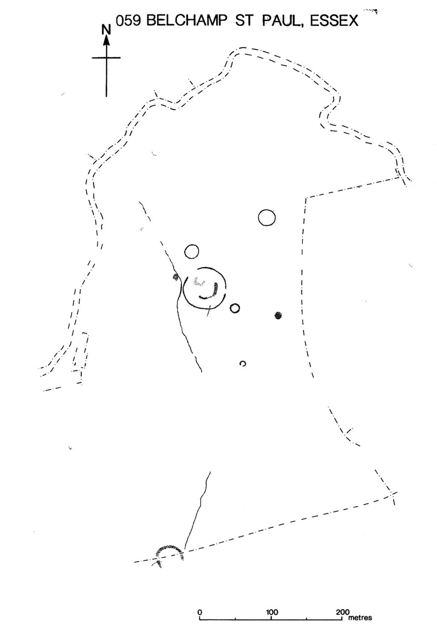
Several hundred yards northeast from Hickford Hill, a cluster of prehistoric sites could once be seen close to each other just south of the River Stour below line of the Essex-Suffolk county boundary. Several of these were tombs and are accounted for in Priddy’s (1981) essay on the prehistoric Barrows of Essex; but adjacent to them were also found faint traces of a large circular enclosure of some sort, which Harding & Lee (1987) included in their definitive survey of British henge monuments. Their account of it was brief and simple, saying:
“Enclosure defined by the cropmark of a sub-circular rather narrow ditch broken by two entrances. No trace of a bank. Internal traces of a concentric innner ditch in part of the circuit… Internal diameter range 56-57m…; width of outer ditch c.1.5-2.5m; width of entrances, c.7m (E) and 16m (NW); width of inner ditch c.2.5-5m.”
Although this large ringed enclosure was thought by the Haverhill & District Archaeology Group to “be a henge-type monument,” Harding & Lee (1987) thought it unlikely that these remains “belong to the henge class” of monuments. A brief archaeological dig into one of the trenches here in 1997 showed the site to be Bronze Age; but finds by the local archaeology team have also come across finds in the fields hereby dating from the Mesolithic and Neolithic periods.
References:
Harding, A.F. & Lee, G.E., Henge Monuments and Related Sites of Great Britain, BAR 175: Oxford 1987.
Priddy, D., “The Barrows of Essex,” in A.J. Lawson’s The Barrows of East Anglia, Norfolk Museums Service 1981.
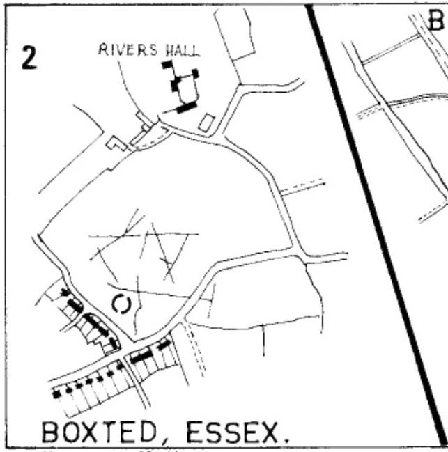
As with many sites in Southern England, intensive agriculture has taken its toll on the archaic monuments. The Boxted Cross henge is no exception and hardly any elements of it remains today. But it seems that it was an impressive fella in our more ancient heathen past.
The site was only rediscovered in the 1970s and was first described in Mrs Ida McMaster’s (1975) survey of crop-marks that had been revealed by aerial surveying in Essex and Suffolk counties. Her brief account of the monument told it to be,
“A Class II henge with a wide somewhat ploughed out ditch. Various linear ditches are near, together with prolific variegated ‘field outlines’ of glacial subsoil cracking which extends into the next field southwards. The ditch terminals of the southwest entrance to the henge appear to be wider than the general run of the ditch, say 4-5 metres.”
When Harding & Lee (1987) examined the site, they were a little more cautious in their interpretation of it being a definite henge, citing that there was “insufficient information, but cannot be ruled out as henge-related,” adding that it “could also be a mill.” This latter element seems unlikely, though a windmill may have been built onto the site at a later date.
More recently however the site has been categorized by Historic England as “a Late Neolithic henge.” The monument itself was defined by a broad circular ditch with two large opposing entrances to the north and south. The total diameter of the enclosure is 44 yards (40m) across; but with the surrounding ditch measuring 5½ yards (5m) across all around, the inner level of the henge was about 33 yards (30m) in diameter. Plenty of room for partying old-style!
References:
Harding, A.F. & Lee, G.E., Henge Monuments and Related Sites of Great Britain, BAR 175: Oxford 1987.
The exact location of this site remains a mystery. Addison (1951) mentions it as being “close to the Blake Hall Road” where a drinking fountain was erected, but notes that this was not the original site of the spring. It was obviously a medicinal spring of some renown to the local people, before it was appropriated by the wealthy to turn it into a ‘spa well’. In doing so, it brought the attention of those curious lords and ladies, along with King James himself, adorning themselves in usual view as important people, and playing the part in social gatherings, as folks did at those spa wells. But the fad didn’t last long and the spa never really caught on. One account tells how it was a dangerous place for the rich and wealthy to visit! Locals can and do get pissed-off if you steal their basic water supplies!
The primary description of the site is that afforded by Christy & Thresh (1910) in their excellent survey of Essex waters. With no mention of the unimportant local people (!), they told how it was “first discovered” in the early 17th century:
“John Chamberlain, the news-letter writer, writing from London to Sir Dudley Carleton, on 23 August 1619, says:
“‘…We have great noise here of a new Spaa, or spring of that nature, found lately about Wansted; and much running there is to yt dayly, both by Lords and Ladies and other great companie, so that they have almost drawne yt drie alredy; and, yf yt should hold on, yt wold put downe the waters at Tunbridge; wch, for these three or foure yeares, have ben much frequented, specially this summer, by many great persons; insomuch that they wch have seene both say that yt [i.e., Tunbridge] is not inferior to the Spaa [in Belgium] for goode companie, numbers of people, and other appurtenances.”
“We have been quite unable to ascertain anything as to the part of Wanstead parish in which this spring was situated. In all probability, it was quite a small spring. One may infer as much from Chamberlain’s statement that, within a short time of its discovery, the company resorting to it had “almost drawn it dry.” If such was the case, the spring was, no doubt, soon deserted and ultimately forgotten.
“Mr. Walter Crouch, F.Z.S., of Wanstead, whose knowledge of the history of the parish is unequalled, writes us : —
“I have always had the idea that this Mineral Spring was not at the Park end of our parish, which abuts on Bush wood and Wanstead Flats, but in the vicinity of Snaresbrook and on the road which leads to Walthamstow; but it is possible that it was in the grounds of ‘ The Grove ‘ (now cut up and built over). The spring is not marked on Kip’s View (1710), nor on Rocque’s large Map (1735), nor on Rocque’s still larger map of a few years later.”
“Under the guidance of Mr. W. Ping, F.C.S., of Wanstead, Mr. Christy has visited two springs at Snaresbrook — namely, that known as the ‘Birch Well’, in the Forest, near the Eagle Pond, and a spring in the grounds of ‘The Hermitage’; but neither of these is credited locally with being a mineral spring and neither has any appearance of being such. Since then, Mr. Ping has written us as follows: “I have spoken with the oldest inhabitant of Wanstead, a Mr. Merryman, whose knowledge, both local and national, is remarkable and accurate. He tells me that the only Mineral Spring he ever heard of in Wanstead was in the grass bordering the roadside nearly opposite the house, in the Blake Hall Road, formerly occupied by Lord Mayor Figgis, and now by Sir John Bethell, M.P. This spring he remembers well. Its water was chalybeate and left considerable reddish deposit. People came and drank it to give them an appetite. They used to kneel down and drink it from their hands, and also took it away in bottles. Others used to bathe their ankles in it to make them strong. Mr. Merryman adds that, about 1870, drainage operations deprived the spring of its water. The fountain, which has since been put up near its site, supplies waterworks water only.” Mr. Ping adds that, recently when deeper drainage operations were in progress at the spot, water of a very markedly ferruginous character was encountered. This is no evidence that this spring was identical with that which came into prominence in 1619, but very likely it was.
“Mr. Dalton expresses the opinion that, if either surmise as to the position is correct, seeing that the comparison with the Tunbridge Wells chalybeate water was sound, the well in question probably yielded a ferruginous water from the Glacial (?) gravels of the Snaresbrook plateau at their contact with the pyritous London Clay.”
References:
Addison, William, English Spas, Batsford: London 1951.
Christy, Miller & Thresh, May, A History of the Mineral Waters and Medicinal Springs of the County of Essex, Essex Field Club: Stratford & London 1910.
Hembry, Phyllis, The English Spa 1560-1815, Athlone Press: London 1990.
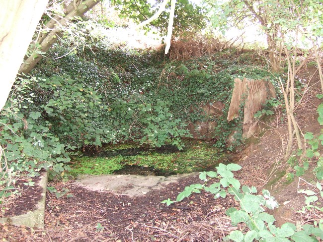
The Runwell (copyright with permission http://www.spiritrealms.co.uk/gallery.htm )
It can be found by taking a road off the A132 (Wickford Road) which leads to Stock (directly opposite the Parish Church), continuing until you reach another minor road to Rettendon. A short way up this road it forks. Take the road to the right & continue until one reaches a minor drive to Poplars Farm (distinctive with its trees each side of the drive). Continue up here until one passes the house to a small piece of tarmac. Here a footpath continues directly in front, continue until one reaches on the left a gate. Enter through here, and head across the field towards a notable tree, and a gap in the hedge. To the left, follow the edge of the field, until one sees another opening into the well. The approach from the south is the only route worth considering as northerly access is blocked by a fence. It can be extremely muddy, so good footwear is advisable.
Archaeology & History
Philip Morant (1763-8) is the first to mention it, suggesting that the settlement is named:
“..from a considerable Running well in the Parish.”
Again, Chandler (1896)—noted in Collins (1986)—emphasises:
“a remarkable spring of water on Poplars Farm, which is always running and has never been known to fail.”
Despite this obvious assumption, Ekwall (1936) suggested that the prefix originates from O.E rune for ‘mystery’ or implying a well possessing a secret of some religious observance. This is suggestive of the strange legends and traditions involved with the site. Alternatively it could derive from hruna referring to the tree trunk—and it does arise in a copse. A roman road runs by here.
The only reference to a religious site appears to be in 1602 when the parish register records ‘Shrine of the Bl. Virgin of RunnyngeWelle’. However, stone remains found over the years around the well may support the idea of a well chapel; these remains were two pieces of limestone window mullion and a piece which appears to be part of a step as well as pieces of Kentish ragstone.
Folklore
According to Bazille-Corbin (1940), Runwell is steeped in lore and legend. One must take these stories as possible antiquarian fancy as there does not appear to be any concrete evidence for them. Doubtless some of it is true, other bits not. He states that in the Sixth Century AD, Christian missionaries Lucus and Lucilus visited Essex and found a scene of paganism here, built a chapel, and rededicated the well to “Our Lady St Mary.” The floor of this chapel had a unique designed cross, with black flint and red strawberry stone, to show the teachings of the tenets of the Christian Faith.
To protect this and collect subsequent devotional gifts, a nunnery, of six members, was developed around the site. They tended to the shrine, well head and the statue of Our Lady, to which many miracles were attributed. Little evidence exists concerning this foundation, but it is believed to have been dissolved in the 16th Century. Locally it is said parts of the nunnery were incorporated into the nearby farm-house ‘The Poplars’. In the 1980s, Andrew Collins, searched for records of this local priory, but found none.
Another legend connected with the well accords that a young nun, Sister Lucy, after renouncing her vows, found the outside world not to her liking and returned in repentance, one snowy night, to the chapel for forgiveness. Yet, upon reaching the chapel steps, she slipped and fell into the icy waters of the well. (cf. The Single or St. Thomas’ Well at Ifield, Kent)
Her ghost is said to haunt the area, preserving perhaps the memories of these past water deities. This is enforced by the belief by some authorities that the well’s dedication indicates a Christianisation of the Iceni goddess Epona. This is supported by these horseshoe-shaped motifs, and that the approach to the well being haunted by a horse.
Andy Collins (1986) was informed that a concrete water tank was installed over the spring. This proved to be inaccurate, but the well was defined by a concrete chamber. Collins thought that this may be the remains of some adaptation for a spa bath, but no hard evidence was forthcoming regarding this.
It certainly had passed through considerable years of neglect, as noted by the Runwell Rector John Edward Bazille-Corbin (1942), who said it was “in much need of dredging and cleaning out.”
The photo shown in Collins’s (1986) work shows a concrete lined rectangular pond, defined by corrugated iron. He was thus responsible for its repair and clearing away the years of neglect, also revealing the concrete rectangular pond, which was reached by a series of steps from its north side. A flight of steps appear to enter the well itself from the front. The body of water is of considerable size and depth and one could easily immerse oneself in it. When I last visited here, the water appeared murky but a sample revealed (apart from the pond fauna) a remarkable clarity.
Within recent years the well appears to have attracted a ‘cult following’, clearly manifesting itself in two ways. One is a seasonal Boxing Day walk to the well started in 1975, which is still undertaken (see link, below). The other more traditionally is the attachment of rags or cloutties to the surrounding shrubbery. Such activity, although probably done by those ‘in the know’ rather than any continuation of any local tradition, is the only such example I have come across in East Anglia—although recent photographs fail to show this and it appears that the tree has been cut down where these have been placed and the area opened up.
References:
Bazille-Corbin, J. E., Runwell St. Mary: A farrago of History, Archaeology, Legend and Folk-lore, 1940.
Collins, Andrew, “Devilish Mysteries at Runwell,” in Essex Countryside Vol. 33 no.431, p38-39, 1985.
Collins, Andrew, The Running Well Mystery, 1986.
Ekwall, Eilert, Studies in English Place and Personal Names, Lund 1931.
Ekwall, Eilert, The Concise Oxford Dictionary of English Place-Names, Oxford 1936.
Morant, Philip, The History and Antiquities of the County of Essex – 3 volumes, London 1763-8 (reprinted by EP: Wakefield 1978).
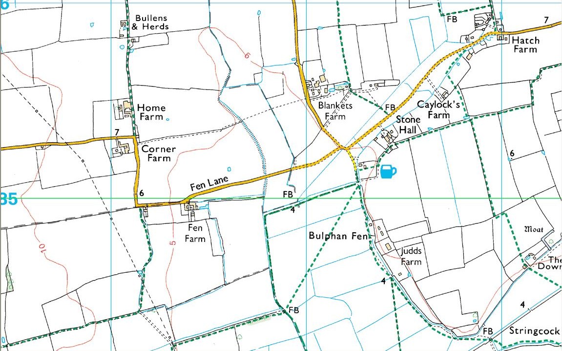
As with many prehistoric sites, this too was unearthed and seemingly destroyed in the 19th century. Although it seems that nothing now remains of the place, the english archaeological fraternity have the site listed as a “Romano-British site”, which seems reasonable; although the lay-out of the barrows or tumuli described and portrayed in the sketch here give a more traditional Bronze Age look. But we may never know for sure. Thankfully a fellow antiquarian called Walter Field (1863) was on hand to make a record of the place before its final destruction. In a short paper he wrote for the Essex Archaeological Society, he told that:
“In the Spring of 1858, a number of labourers were employed in trenching some fields belonging to Holme Farm, forming part of a large tract of land called Bulphan Fen, and situated about a mile-and-a-half west of the village of North Ockenden. In the course of their operations they found a number of beds of dark soil, in which were a large quantity of bones, supposed at first to be human, together with fragments of pottery and pieces of charcoal. It was the general belief among the workmen that the field had been the scene of some great battle, a belief supported by some local traditions. One thing seems certain, that it is the site of a Roman or early British Burial Ground, extending over a space of about sixteen acres; but whether it marks the battlefield of one of those many great struggles which took place in this county between the Britons and Romans, or whether it denotes the peaceful cemetery of a Roman Station, it is perhaps not very easy to determine.
“The little evidence, however, which the plough and the harrow have left remaining, seems in favour of the latter. The regular and almost equidistant arrangement of the lines of dark soil in many parts, and the many fragments of cinerary urns found in nearly all of them, seem to indicate rather the orderly interment of a cemetery, than the more hasty burial of a battle-field; but this is by no means conclusive.
“The graves are at once discernible from the surrounding soil, the natural soil being a yellow clay, whilst the earth of the graves is nearly black. It is impossible, with any accuracy, to trace the exact forms of the graves, some appear to be circular, and to vary in size from 10 to 40 feet in circumference, others appear to be of an oblong form; one grave is much larger than the rest, and is of about 60 feet in length and 20 in width. There are doubtless more of these graves in the bordering fields. It is worthy of note that a neighbouring meadow is called the Church Field, and a portion of the land on which these discoveries were made is still called Ruin Field. Both these names, probably, have reference to the formerly uneven sur&ce of the ground, caused by a great number of burial mounds. The fragments of Pottery vary much in their character, some being of the very rudest workmanship, whilst others have been more carefully manufactured; and a few small pieces of Samian Ware were found; mingled with them, were the bones of different animals — the horse, the deer, the boar, etc., but no human bones; much of the earth, stones, and pieces of wood bear evident marks of the action of fire; beyond these there was nothing found, except a portion of a flint arrow-head and a part of a hand mill stone. Not a single coin or piece of metal was discovered. The circumstances that all the fragments of pottery, and nearly all the bones of animals, are broken up into small pieces lying equally at the bottom as at the top of the dark soil, and that the graves are about three feet deep, narrow at the bottom and widening to the surface, lead me to think that the present graves are only the trenches of the original barrows, but that the field has been gradually levelled for agricultural purposes, and that the plough and the spade have in process of time filled up the original trenches with the soil, urns, bones, &c., of the burial mound.”
References:
Field, Walter, “Discovery of British and Roman Remains at North Ockenden and White Notley,” in Transactions of the Essex Archaeological Society, volume 2, 1863.
This site entry is dedicated to Sarah Hunt, once of North Ockendon, wherever she may be…
Decorated prehistoric urn from St John’s Green tumulus
In a prehistoric burial mound that was destroyed by the usual self-righteous arrogance of industrialists, this well-decorated urn or beaker in the old photo (right) was somehow retrieved. Included in Dave Clarke’s (1970) major survey on such vessels (as an Abercrombie type A, no less!), the remains came to light in January 1930, “during the laying of a gas main under the west footpath of Flagstaff Road, about 100 yards south of St. John’s Green.” Although the barrow or tumulus had already been levelled, sheer diligence and care on behalf—one believes—of antiquarian M.R. Hull saved the vessel from an otherwise inevitable doom!
In Mr Hull’s (1946) article on to this and other similar finds in Essex, he described how the urn, about seven inches high,
“…stood upright in the side of the trench, only 18in below the surface. The ground had been disturbed before, and one side of the beaker was badly damaged… The clay was fine, but contains some sparse grit, fairly large and white. It is light brown-red in colour and black in the break. The body is decorated all over with impressed lines, some done with the print of a stick or bone, some in an indefinable way which produces an almost maggot-like impression of varying length, and some with the end of a comb, as on the Type B beakers, but the teeth are oblong (very narrow) instead of square—the comb in fact, was very thin, at least at the point.”
References:
Clarke, David L., Beaker Pottery of Great Britain and Ireland – volume 2, Cambridge University Press 1970.
Hull, M.R., “Five Bronze Age Beakers from North-East Essex,” in Antiquaries Journal, volume 26, Jan-April 1946.
Tumulus (destroyed): OS Grid Reference – TM 0628 2022
Archaeology & History
Alresford Hill urn
In a region well known for the finding of early British remains (Belloc 1905), another prehistoric burial mound was destroyed in the Essex landscape simply due to ignorance and neglect. Thankfully once more we have local antiquarians and an astute schoolgirl for discovering and preserving a record of this site, otherwise we’d have no record of the place at all! Described in M.R. Hull’s (1946) article on some of the Bronze Age relics of the area, he told how a well-preserved urn in the edge of the tumulus,
“was found in June 1942 by a schoolgirl, Miss Anne Pilkington, on the top of the hill overlooking Alresford Creek and the Colne Estuary, about 70 yards northwest of Bench Mark 74.8 and 560 yards slightly west of south from Alresford church, west of the road to the creek and south of the lane running west along the north side of the field. This is the northern limit of a huge gravel-pit. She noticed the vessel standing upright in the side of the pit and recovered it. Nothing else was noticed…
“Afterwards the diary of our late Fellow, Mr P.G. Laver came into my hands and I find under the date 8th July, 1922, that he noticed, when motoring past the site, ‘a definite tumulus, but much ploughed down, now barely 18ins above the field level. It is close to the road through the field, the centre being roughly 20 yards S of the road and about 200 yards from the road to the ford.’ The sketch-plan leaves no doubt on the identity of the site.”
Annoyingly though, Mr Hull didn’t think it worthwhile to reproduce this alleged sketch-map. He did however give us a good description of the urn and its position in the ground, saying,
“The vessel is stated to have been about 5ft below the surface when found, but I am not certain whether the top-soil had been removed or not. The clay is fine, burnt light red, but black within, and the whole body is covered with horizontal lines impressed in exactly the same way as (those on the Flag Inn urn), but much less clearly. The base is slightly hollowed beneath and is not far from having a foot-ring.”
Folklore
Mr Hull (1946) also made an interesting comment on the views of local people about the site where Anne had found this urn, reminding me of what Highland and hill folk would have put down to faerie-lore, though no such memory was noted. He told:
“On enquiry I learnt that no one had observed a mound at the spot, but that it had been observed that exactly there the corn, when the field was cultivated, grew taller and greener in a large round patch”!
References:
Belloc, Hilaire, The Old Road, Archibald Constable: London 1905.
Hull, M.R., “Five Bronze Age Beakers from North-East Essex,” in Antiquaries Journal, volume 26, Jan-April 1946.
Tumulus (destroyed): OS Grid Reference – TM 117 178
Archaeology & History
Bronze Age beaker from the Flag Inn tumulus
Roughly halfway between Thorrington and St. Osyth, a few hundred yards east of the Flag Creek on the grassy wasteland south of the historic Flag Inn, could once be found a fine tumulus, of whose past we sadly know so little. Nothing now remains of the old burial mound apart from a carved urn that once lived therein and was recovered from the site before its final demise. According to M.R. Hull (1946) the well-preserved Bronze Age beaker found here—which he said “stood out as different” from others in this area—
“was found in 1930 on the 50ft contour-line about 200 yards south-southeast of the Flag Inn, in a gravel pit, in St. Osyth parish. The position is a mile and a quarter north-northwest of St. Osyth church. On this occasion it was not possible to examine the site, which could only be established with moderate accuracy some time after the discovery…
“The clay is fine, of light red colour, ornamented with three bands of trellis pattern, each bounded by three horizontal lines, and a band of four such lines at the base, all executed with an instrument making a short line of square impressions, probably the end of a comb used in weaving.”
References:
Hull, M.R., “Five Bronze Age Beakers from North-East Essex,” in Antiquaries Journal, volume 26, Jan-April 1946.
Tumulus (destroyed): OS Grid Reference – TL 8228 2704
Archaeology & History
Aerial image showing ghostly circular outline
This is one of many lost prehistoric burial sites destroyed in Essex in recent centuries and whose only remains now, as seen here to the right, are the ghostly outlines left in the Earth when looking down from above. We are very fortunate indeed in even having a record of this place—this time thanks to an astute fellow antiquarian hearing of some old remains alleged to have been in an old burial mound, south of Greenstead Green.
It’s short story was described in M.R. Hull’s (1946) essay on a series of Bronze Age beakers in Essex that were found in association with once-proud tumuli, living amidst a landscape held as sacred by our peasant ancestors. Although we have no good description of the tumulus, Mr Hull said that this well-preserved clay beaker,
Perces Bronze Age beaker
“was found in 1930 on the 200ft contour-line 366 yards due south of Piercys in the parish of Halstead…that is 2¼ miles south-southeast of Halstead Church. I visited the site immediately after the discovery with our late Fellow, Mr P.G. Laver, and the finder assured us that no other remains were found. He had dug a small pit into the natural gravel, and in doing so came upon this vessel at a depth of 7ft from the surface. When we arrived the burial pit had been destroyed, and, although the depth of the vessel from the surface suggests that a tumulus existed, we were unable to see any remains of it. We found a calcined flint…in the excavation. The vessel…(of) clay is fine, containing a very small quantity of quartz-like grit; the colour is a warm red-brown, and the body is decorated all over with finger-nail impressions.”
References:
Hull, M.R., “Five Bronze Age Beakers from North-East Essex,” in Antiquaries Journal, volume 26, Jan-April 1946.
Tumuli (destroyed): OS Grid Reference – TM 022 143
Also Known as:
Barrow Hills
Five Barrows
Archaeology & History
Known as Five Barrows presumably from the five main burial mounds that were once here, very little in modern texts seem to describe them. In the grid-reference given above, I’m not 100% certain that this is the correct spot – and as many of them have been destroyed, we’ll stick to this until someone tells us otherwise! (it is only Essex anyway)
The ‘barrow’ site that remains has been ascribed as Romano-British in date, whilst the others don’t seem to get a modern mention. These missing barrows were described in a short article in The Gentleman’s Magazine by a Mr J.A. Repton (1840), who told the following:
“In reading an account of Essex, I find the following Borough, or rather Barrow Hills, on the north side of the Black Water Bay, were considerable in number. These tumuli are supposed to have been raised indiscriminately over the bodies of the Danes and Saxons that fell in the battles occasioned by the frequent landing of the former in this part of the coast. The lands on which the barrow hills stood were completely inclosed from the sea in 1807, and the whole are now levelled, one excepted.
“This barrow I heard was going to be cleared away for manure. I made a point of visiting it under an idea that it might be proved a Roman one; when I arrived at the spot, I found it to be a bowl barrow, about 14 yards diameter, and about 6 or 7 feet high, and rather more than half of it cut away, and what surprises me, not a single urn, bone, or ashes, nor any mark to be found; perhaps the barrows being mostly under water during the tide may account for the disappearance of bones, etc., if there ever were any placed; or rather that the Danes and Saxons were not so careful as the Romans in preserving the remains of their friends. I met one of the old inhabitants who lived in the parish more than forty years; he remembered the number of barrows being destroyed, and said not a single bone or urn was ever found in them.
“Perhaps you can give me some information, whether by digging below the natural surface of the ground, any remains may be traced. It is not a gravelled, but a clean, light clay soil. The land is low and marshy, and celebrated for Maiden salt, and near it there is a decoy. ”
If anyone has further information about the other barrows which are described in several old early accounts, it’d be good to know!
Folklore
Archaeologist and folklorist Leslie Grinsell (1976) noted briefly that the barrows here supposedly covered the remains of Danes who died in battle here.
References:
Grinsell, Leslie V., Folklore of Prehistoric Sites, David & Charles: London 1976.
Repton, J.A., “Borough Hills, Essex,” in The Gentleman’s Magazine, 1840 (part 2, p.114).