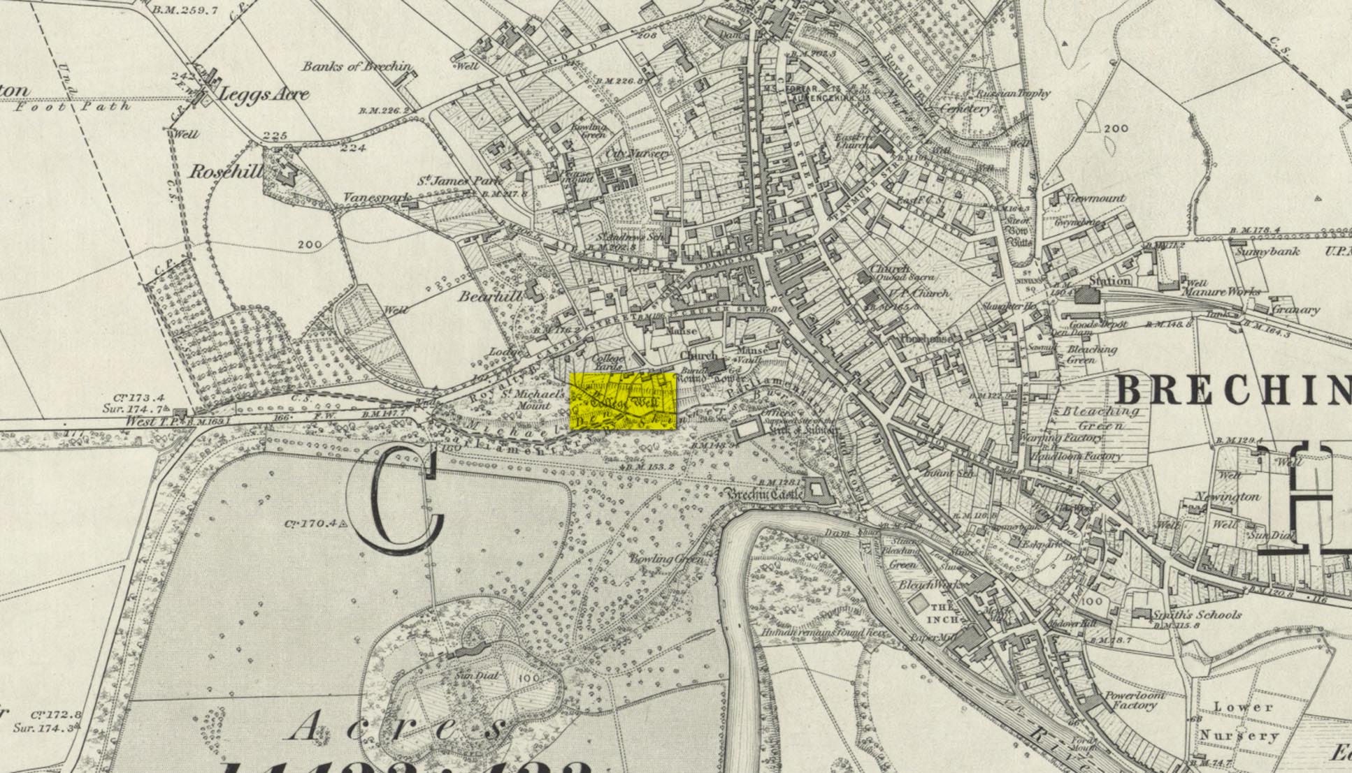
Highlighted on the 1865 OS-map, this lost water source was located between the Brechin cathedral/round tower and the curiously-named St. Michael’s Mount, whose history seems to be lost. It would seem to be the well which Ruth & Frank Morris (1981) name as the ‘Ancient Well’ in their survey.
Folklore
The reason behind this site being classified as a sacred (or holy) well is based on the tradition that the Culdees had a religious convent here in the 12th century and, according to David Black (1839),
“This convent is believed to have stood a little to the west of the present parish church, in the gardens now belonging to the kirk-session, still called “the College Yards.” A small well of delightfully pure water in these gardens receives the name of the College Well, and is reported, by tradition, to have been the well of the Culdee convent.”
On the issue of St. Michael, students of folklore will know that, in the christian cult, he was an early dragon-slayer. His annual commemoration day is September 29. One of his shamanistic functions “relates to the very old tradition of Michael as the receiver of the souls of the dead.” (Attwater 1965)
References:
Black, David D., The History of Brechin, Alexander Black: Brechin 1839.
Gibson, Colin, Folklore of Tayside, Dundee Museum c.1968.
Acknowledgements: Huge thanks for use of the 1st edition OS-map in this site profile, Reproduced with the kind permission of the National Library of Scotland.
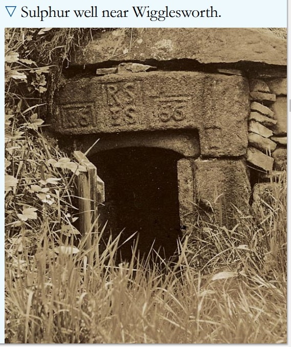
In William Addison’s (1951) standard work on the history and development of Spa Wells, he told us that “the spas began as holy wells”; yet in spite of him listing the Wigglesworth Spa in his work, such “holiness” wasn’t a feature found here and, sadly, we have no written records that tell of any. But that doesn’t mean to say it had no sense of importance or animistic sacrality to local people. The earliest written record we have of this Sulphur Well is to be seen on the stone-work at the top of the small well-house, where the year “1666” was carved, marking the year when the structure was built under the directions of a local rich dood. But earlier knowledge of these healing waters would have been passed to the land-owner by local people, as indicated in Thomas Short’s (1765) words where he told that “it has been used time out of mind.”
Mr Short (1724) makes mention of this Sulphur Well in his gigantic early work, but only in its similarity in both taste and smell to the Sulphur Well at Harrogate and letting us know that, “I have tried carefully” the waters of the two sites. We had to wait another forty years before he gave us a more detailed account of the medicinal properties here. He wrote,
“Now come we to a sulphur water of a very peculiar nature, such as I never met with or heard of in England besides, and deserves to be much more strictly examined and enquired into, viz. Wigglefworth Spaw, near Settle, in the parish of Long-Preston. It has been used time out of mind, and more formerly than at present, because it is little known; rains and drought affect it not. Country people drink four or five pints of it in a morning to vomit them, and six or seven pints to purge them. The water is very black, smells strong of sulphur, has a very small stream, but stagnates not, bubbles not, but springs up; it is always covered with a white scum, (and) dies all in its course white. It rises out of a great stone soil, near much lime-stone, at the foot of a hill. It tastes salt, yet curdles not soap, and boils with milk. A phial glass, one third part full of it, well corked, and tied down with a bladder, and set in the cold water to be evaporated; when the water began to boil, it was taken out and poured a little of it on solution of silver, which turned black and curdled. The phial was corked again, and set half an hour longer in the boiling water, it still turned solution of silver black. It was corked a third time, and set half an hour longer in the boiling water, then tried, but was not so black as before, and caused little curdling. This last stood all night, next day its precipitation was blackish; the water was clear above. This is the only blackish sulphur water I have met with (as Rippon is a greenish yellow) and retains its sulphur the longest, from its contained oil.”
Consistent with other writers of his time, Mr Short then wrote at length on how the Wigglesworth waters reacted to various chemical tests, many of which were done in order to indicate the veracity, or otherwise, of any medical qualities. He also made comparative studies between this and the sulphur wells at Harrogate and elsewhere, and concluded that the Wigglesworth Spa would successfully deal with the following ailments or conditions:
“Sloth, idleness, too violent slavish exercise or labour, too great affluence, or plenty of nourishing rich high foods, spices, forced meats, acrid, stimulant and aromatic viands; the earthy viscid dregs of fermented liquors, or the parching, drying, shriveling spirits of wine, sugar, fruits, grain, or fermented liquors, as well as poverty and unwholesome diet, irregular hours, etc, are the parents of many diseases, whose cure lies in relieving oppressed nature from the unwieldy load (brought upon her by indolence, gratifying the vitiated taste, intemperance and debaucheries) by cleansing and rousing the vessels, restoring the juices to a healthy state; rectifying and establishing the secretions and excretions of the body, and restoring vigour and activity to the fibres, vessels and solids. To the above causes of diseases, we may add pride, luxury, sensuality, inverting the natural course of time, turning day to night, and night to day. These give birth to many chronic diseases, as well as acute, from acidities, crudities, viscidities in the stomach, communicated thence to the bowels, and so to the whole habit; hence are vitiated juices, great obstructions, and a long train of diseases affecting sundry parts of the body, and therein the whole nervous system, with hypo, hysterics, melancholy, costiveness, or looseness, suppression of natural necessary discharges, etc., which require thinning, relaxing, resolving, opening, or invigorating remedies.”
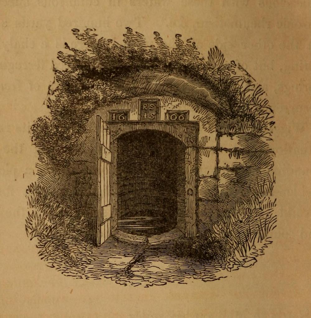
Photo of the well, c.2008Howson’s 1850 sketch
For about two centuries this well had a very favourable reputation. It’s therefore slightly curious as to why the great spa-writer, A.B. Granville, in his visit to this part of Ribblesdale to seek out some of the medicinal springs in the 1830s (including a petrifying well), made no mention of our Sulphur Well. Whether this was due to his patronizing attitude towards local people isn’t known, but it certainly wouldn’t have helped him in Yorkshire! One might suggest it was due to the fact that the spa had fallen into disuse, but this wasn’t the case because, subsequent to Granville’s visit, the local writer William Howson (1850) later told us that,
“In the woody dingle to the north of the village is a sulphurous spring, protected by a neat and antique stone canopy bearing the date 1666, and the initials of Sir Richard Sherburne and Isabella his wife, a daughter of John Ingleby of Lawkland Hall. Of this well, Dr (John) Murray the well-known analytical chemist says, ” It is a most valuable and unusually strong sulphuretted water, and as far as I have examined mineral waters, second to none.” From his analysis and that of Dr. Garnett it appears that a gallon of the water contains seventeen cubic inches of sulphuretted hydrogen, four of azote, and a small portion of carbonic acid, sulphate of magnesia in the proportion of seventy five grains to a gallon, a considerable quantity of muriate of soda, and a minute proportion of carbonate of lime.”
(The aforementioned Dr Garnett was a renowned 18th century authority on medicinal wells in Yorkshire, best known for his works on the spa wells of Halifax (1791) and Harrogate (1791, 1792), along with some in Scotland.)
Messrs Short (1765) and Howson (1850) mentioned other medicinal springs very close by, including the Chalybeate Well in the field immediately north on the other side of the stream.
References:
Addison, William, English Spas, Batsford: London 1951.
Brown, G.H., Walks, Drives and Excursions around Settle, Craven Printing: Settle 1880.
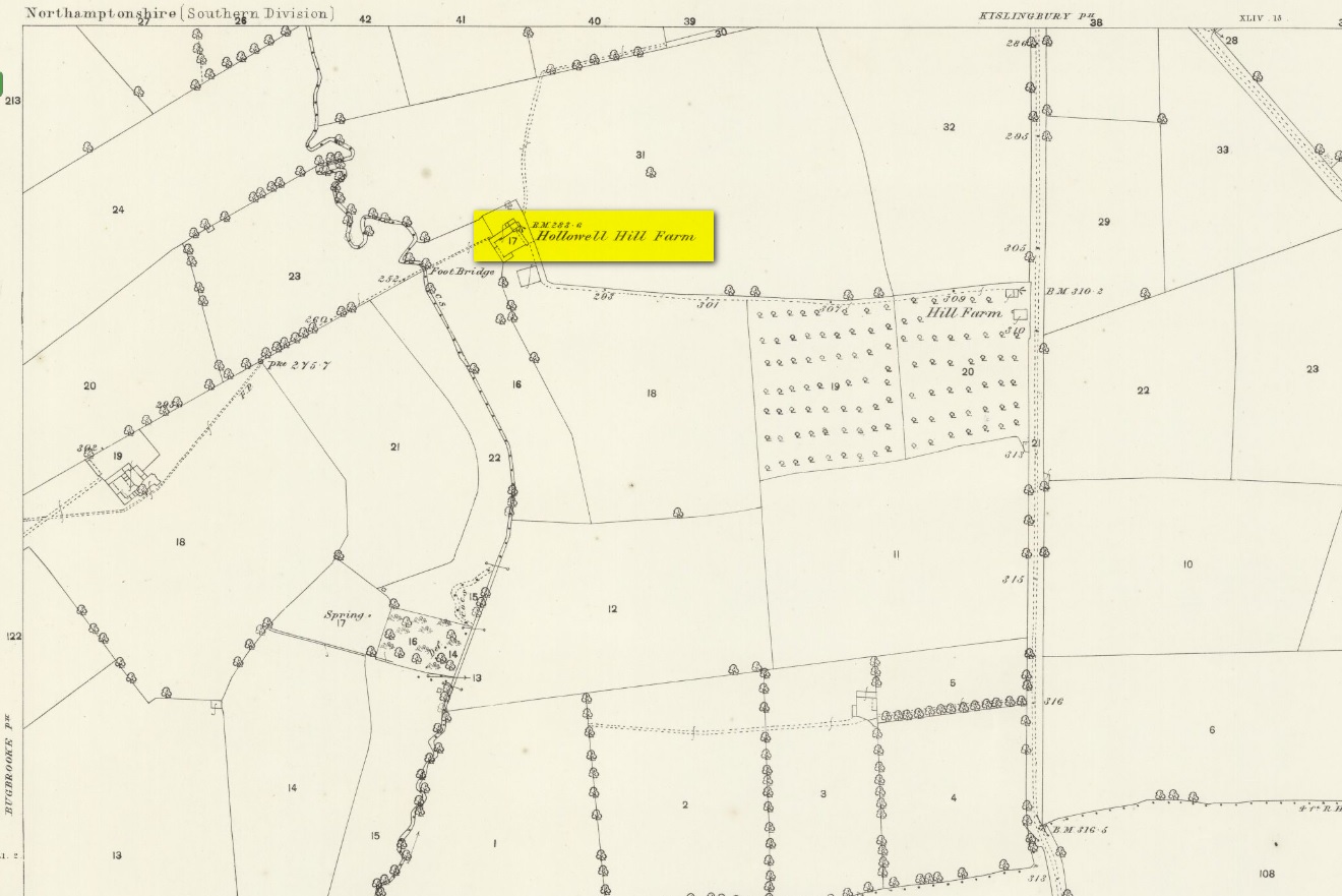
A mile south of Kislingbury village, just by the roadside is the old Hill Farm. In times gone by—as the early OS-maps show—a trackway led from here, westwards, for just a few hundred yards, until it reached the old farm of Hollowell Hill, all trace of which has long since gone. The farm owed its name to the existence of a holy well mentioned briefly in 14th century records in the Cartulary of St. Andrews, Northampton, where it was described as Halywellhille, or the Holy Well on a hill. All trace of it seems to have been lost. A ‘Spring’ that is shown on the 1885 map, a few hundred yards south of the old farm, seems to be the closest contender, but it seems more likely that the well was adjacent to, or beneath the farm-building.
References:
Gover, J.E.B., Mawer, A. & Stenton, F.M., The Place-Names of Northamptonshire, Cambridge University Press 1975.
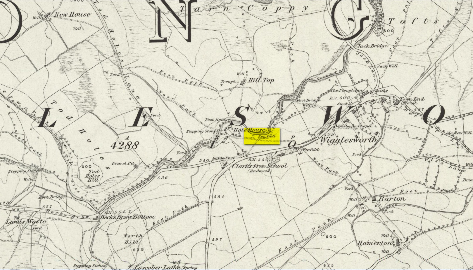
Healing Well (destroyed?): OS Grid Reference – SD 8047 5700
Archaeology & History
In Thomas Short’s (1765) description of the once-renowned Wigglesworth Sulphur Well, he mentioned briefly that there were “some (other) chalybeates near it.” Thankfully 85 years later, with the aid of William Howson (1850) who gave us a marginally better description, we were able to locate the whereabouts of one of them! From the Sulphur Well, this one could be found,
“two hundred yards above, on the other side of the rivulet there is a chalybeate spring, but (it was) of no unusual strength.”
In fact it’s a little closer to being 300 yards than 200—but that’s a minor issue in the grand scheme of things! The place in question was marked on the 1852 OS-map, marked simply as a “Well.” …This iron-bearing spring would have been a good pick-me-up and, as with all such wells of this nature, fortifies the blood and the immune system. Mr Howson also told us that “ferrugineous springs, stronger than this, are of frequent occurrence in the neighbourhood,” echoing Short’s earlier remark. Sadly, it seems that all trace of this Well has disappeared.
This long-lost stone cross should not be confused with the more recent one, erected by one Mr H. C. Richards in 1901 to commemorate some malarky about Edward VII. The one in this profile was much older than that, although both of them were erected close to each other. The older cross was found, said T.H. Cole (1884), “at the head of the Town, near All Saints’ Church.” Also known as the North End’s Cross, the old market was held here and close by were the gallows, the whipping post and the stocks.
Sacred Well (destroyed): OS Grid Reference – SE 17567 35473
Also Known as:
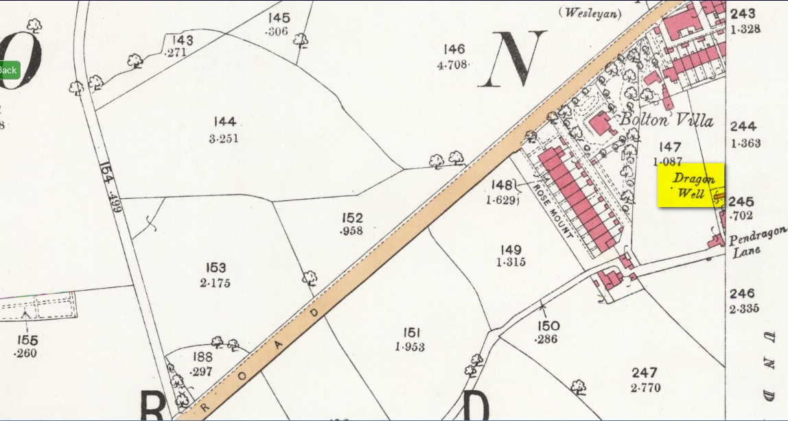
Pendragon Well
Archaeology & History
Site on the 1893 map
A most curious place: this ‘Well of the Dragon’ as it was first called (on the 1852 OS-map) and subsequently the ‘Pendragon Well’ (on the 1922 map) just off Pendragon Lane, seems to have been forgotten in both folklore and history. I grew up round here and no legends of dragons were known, either in my life, nor that of the old folks I knew; nor any pub of that name that might account for it.
Equally unexplained is the name of the adjacent ‘Pendragon Lane’, which has been known as that for some 175 years. We have no Arthurian myths anywhere in West Yorkshire that remains in folk memory—and certainly nothing hereby that accounts for it.
As for possible landscape associations (i.e., serpentine geological features), nothing in the vicinity has any bearing on the name. Indeed, the only thing of any potential relevance was the former existence of a healing rock known as the Wart Stone, some 100 yards to the east at Bolton Junction. Such stones are usually possessed of naturally-worn ‘bowls’ of some sort on top of the rock—akin to large cup-markings—into which water collected that was used to rid the sufferer of warts or similar skin afflictions. But such an association seems very unlikely.
The only thing we can say of this Dragon Well is that probably, in times gone by, a folktale or legend existed of a dragon in the neighbourhood that had some association with the waters here. Dragons are invariably related to early animistic creation myths, and this site may have been all that remained of such a forgotten tale. The nearest other place in West Yorkshire with dragon associations is six miles northwest of here on the south-side of Ilkley Moor. In Britain there are a number of other Dragon Wells, the closest of which is in South Yorkshire.
In John Bridges’ (1791) account of the parish of Aynho, he made mention of an old market cross that stood in the village, but even in his day it had been removed and so we know little about it. Chris Markham (1901) included it in his inventory of crosses, but could find no additional details to those provided by Mr Bridges. He told us:
“In the seventeenth year of Edward II (1323-4) John de Clavering was lord of the manor of Eynho, and obtained the King’s charter for a weekly mercate, or market, to be held every Tuesday, and a yearly fair on the vigil and day of St. Michael and two days following. This market was continued until the twentieth year of James I (1622-3), when Richard Cartwright obtained a new charter for holding the market and fair, with the addition of another yearly fair on the Monday and Tuesday after Pentecost. Bridges, however, writing about 1700, says that the market had been discontinued for some sixty years, and that the market cross had been then long since taken down. Since then the fairs have also sunk into desuetude.”
References:
Bridges, John, The History and Antiquities of Northamptonshire – volume 1, T. Payne: Oxford 1791.
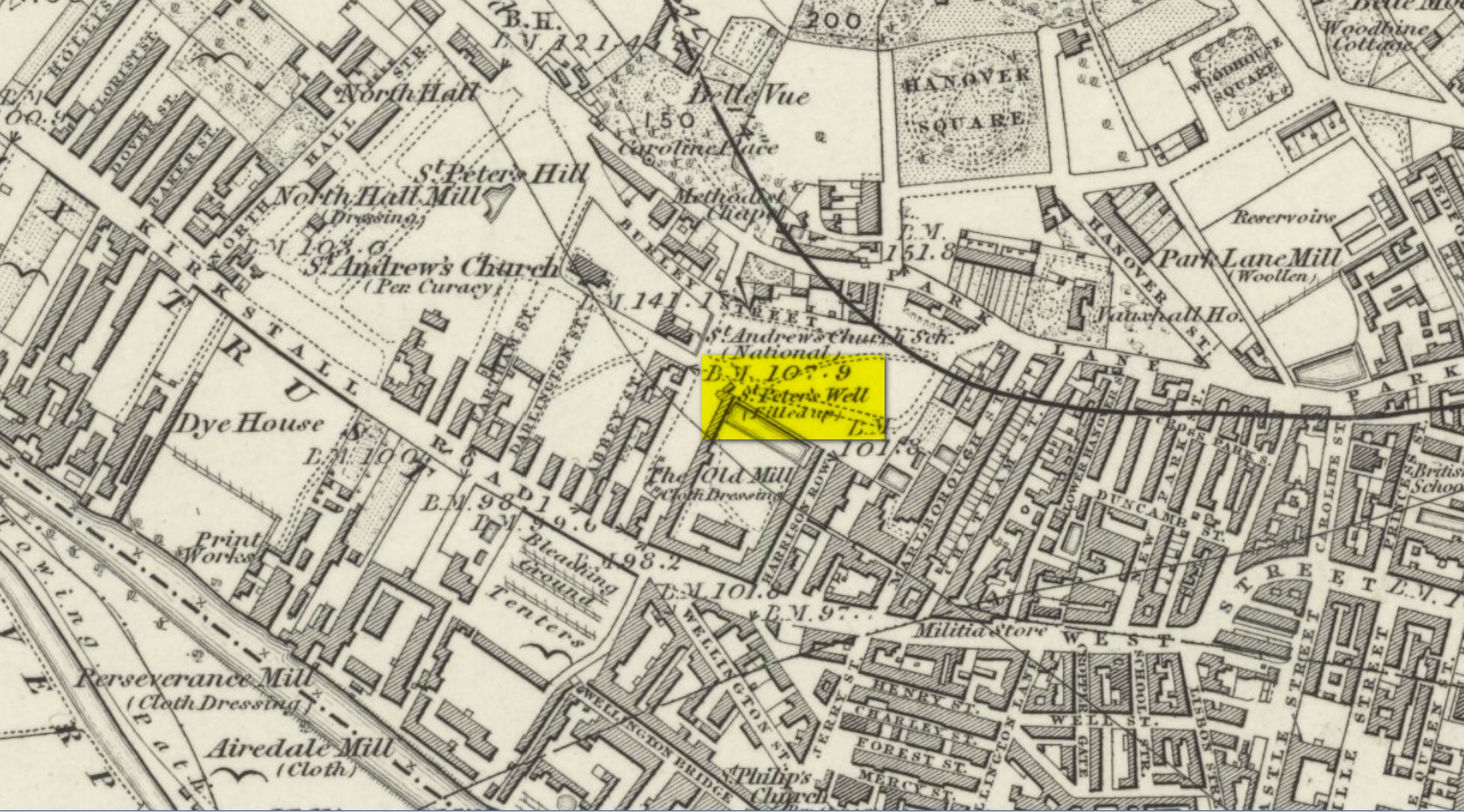
Holy Well (destroyed): OS Grid Reference – SE 2894 3382
Archaeology & History
St Peters Well on 1852 map
Not to be confused with the other St. Peter’s Well that once existed in the city centre, this site was shown on an 1815 map of Leeds (which I’ve not been able to get mi hands on!), known as the Waterloo Map. But when the Ordnance Survey lads visited the place in 1846, it had been covered over. Immediately west of here, the saint’s name was also given to a nearby hill, whose folklore seems has been forgotten.
Although Ralph Thoresby mentioned it in passing, Edward Parsons (1834) gave us a brief description of its qualities, telling us that,
“Near North Hall is the celebrated spring called St. Peter’s Well ; the waters are so intensely cold that they have long been considered very efficacious in rheumatic disorders.”
Bonser (1979) reiterated this in his survey, also telling that, like its nearby namesake, its waters were “intensely cold and beneficial for rheumatism, rickets, etc.” An old bathing-house that was “annexed to the Well” may have been used specifically to treat such ailments, but we cannot say for sure.
Interestingly, Andrea Smith (1982) told that 400 metres away a well was sunk in 1838 and a quantity of petrified hazelnuts were recovered from a broken red jar which had a female head painted on it. Such a deposit is not too unusual, as a number of sacred wells in bygone days were blessed with nuts and signified the deity Callirius, known by the Romans as Silvanus, the God of the Hazel Wood – though we have no direct tradition here linking St. Peter’s Well with this ritual deposit.
St. Peter’s festival date was June 29.
References:
Bonser, K.J., “Spas, Wells and Springs of Leeds,” in The Thoresby Miscellany – volume 54, Leeds 1979.
Hope, Robert Charles, Legendary Lore of the Holy Wells of England, Elliott Stock: London 1893.
Parsons, Edward, The Civil, Ecclesiastical, Literary, Commercial and Miscellaneous History of Leeds, Halifax, Huddersfield, Bradford, Wakefield, Dewsbury, Otley – volume 1, Frederick Hobson: Leeds 1834.
Smith, Andrea, ‘Holy Wells Around Leeds, Bradford & Pontefract,’ in Wakefield Historical Journal 9, 1982.
Healing Well (lost): OS Rid Reference – NS 579 884
Archaeology & History
One-and-a-half miles east of Balfron, this curiously-named well could once be seen – and indeed may still be there. Mentioned just once in D.S. Buchanan’s (1903) Guide as a well-known place, I’ve been unable to locate it and can find no other accounts of the place. He wrote:
“A little beyond Dailfoil there is a road to the right, down which, about 200 yards, there is a stile over the fence, only a few feet from the famous Gerchew Well, on the banks of the Endrick. Here the visitor can repose for a time under the shade of the trees, and quench his thirst in its pure, cool, and bubbling waters.”
His directions seem to indicate it as being just off the small road that runs to the ruins of Easter Gerchew, but there is nothing of note hereby. A half-mile away was Wester Gerchew house, which seems contrary to his directions —and there’s nothing in evidence there either. And so I enter it here in the hope that someone might be able to relocate this healing well. (the grid reference is an approximation based on Buchanan’s description)
References:
Buchanan, D.S., Buchanan’s Popular Illustrated Guide to Strathendrick, Aberfoyle and District, J. & C. Buchanan: Balfron 1903.
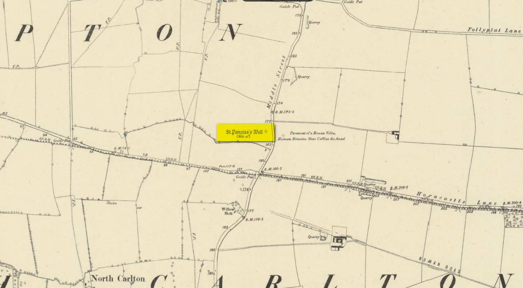
Holy Well (destroyed): OS Grid reference – SK 9542 7853
Archaeology & History
Site shown on 1886 map
Mentioned in Thompson’s (1999) survey but without comment, it was, curiously, Skyring Walters’ (1928) that drew my attention to this site. He added it to his list of St Pancras sites, telling how even in his day, it had fallen into memory. Indeed, it had already gone when the Ordnance Survey lads came here in 1885. Thankfully we were left with an albeit piecemeal account of the place by Cayley Illingworth (1810) before its destruction. It was an iron-bearing well that existed some fifty yards from an ancient Roman villa and was probably the water supply for the Romans who lived here. He told us:
“The circumstance…of the chalybeate spring within a few yards from the entrance of the villa, and still called Saint Pancras Well…favours the conclusion of a chapel having been erected on its site. (This) is supported by the strong evidence of a discovery, upon record, that a chapel dedicated to Saint Pancras did actually exist on this spot, so early as the beginning of the twelfth century; about which period Richard Fitz-Robert of Scampton gave to the monastery of Kirksted three selions of land in that lordship, two of which are described in the gift as lying in the south field, on the south side of the chapel of Saint Pancras.”
He further told that at the bottom of the well an oak floor had been laid, which had been dug up “several years ago.”
St Pancras’s festival date is April 3.
References:
Cameron, Kenneth & Insley, John, The Place-Names of Lincolnshire – volume 7, English Place-Name Society: Nottingham 2010.
Harte, Jeremy, English Holy Wells: A Sourcebook – volume 2, Heart of Albion Press: Loughborough 2008.
Illingworth, Cayley, A Topographical Account of the Parish of Scampton in the County of Lincoln, T. Cadel & W. Davies: London 1810.
Thompson, Ian, Lincolnshire Springs and Well, Bluestone: Scunthorpe 1999.
Walters, R.C. S., The Ancient Wells, Springs and Holy Wells of Gloucestershire, St Stephens Press: Bristol 1928.