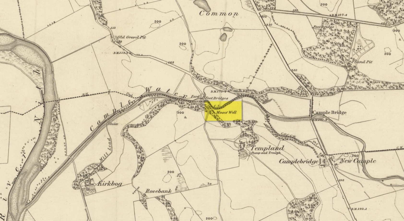
This little-known Biblical-sounding spring has apparently long since fallen back to Earth (perhaps there might be some local folk who could find out for certain). Shown on the 1861 Ordnance Survey map as being at the side of the wall in the small copse of trees—immediately east of kirk- place-names and a half-mile north of St Ninian’s Well—it was briefly described by T.C. Ramage (1876), who seemed to know nothing of its lore, merely telling us that,
“on Templand farm, close to the wooden bridge over the Cample, there is Moses’ Well, an unusual designation, but which some Knight Templar may have given in remembrance of his toils in Palestine.”
The Templar designation was deemed by Ramage to come from the name of the farm. However, a few years prior to this, the early Scottish place-name surveyors were traversing the area and found from local people how it derived “its name from a Tinker named Moses Marshall who with his family lived near it in a Camp during the time they had the small pox.” The Well was also included in the Morris survey (1982), but without comment. Another Moses Well can be found 44½ miles to the northeast, near Galashiels at NT 4046 4306.
Holy Well (destroyed): OS Grid Reference – SE 6071 5187
Archaeology & History
At the beginning of the 19th century, William Hargrove (1818) described the scant remains of some old walling along old Haver Lane (renamed as Green Lane and now known as The Stonebow) which were the remains of a building, long gone, and which,
“tradition informs us (was) a religious house, which formerly stood here, called Holy-Priests; and though the site of it is not known, the report is greatly strengthened by the appearance of the walls just mentioned, and by the circumstance of a deep draw-well which now remains, being still called Holy-Priests Well.”
Some suggest that this water source may still exist beneath one of the buildings hereby, but the landscape here has been so badly mutilated over the last two hundred years that it’s very unlikely.
References:
Hargrove, Willliam, History and Description of the Ancient City of York – volume 2, part 2, W. Alexander: York 1818.
Holy Well (destroyed?): OS Grid Reference – SO 9609 8284
Archaeology & History
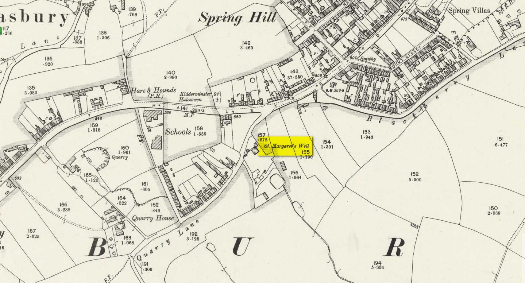
The site on the 1904 map
Shown on the 1904 OS-map, beneath the aptly-named St Margaret’s Hill on its northern side, we can see where the holy well of St Margaret used to be, not too long ago. Although it seems to have fallen pray to industrial destruction, there are a number of old references to the site, mainly gathered together in Jeremy Harte’s (2008) magnum opus on the subject. It was also mentioned in a survey by the British Geological Society (Richardson 1930) where we were told that it was,
“in the private grounds of a house recently erected, and is a spring issuing from the Halesowen Sandstone at the junction of two faults (shown west of the ‘H’ of Hasbury on the new series Geological Map, Sheet 168) about 100 yds SW of the point where Blackberry Lane joins Hagley Road. It is referred to, as a well of good cold unmineralised water, by T. Nash in 1781.”
And it was Mr Nash who gave us the earliest description of the place, saying:
“In the hamlet or township of Hasbury is an ancient holy well, called St Margaret’s Well, which formerly had much good stonework about it; but that was wholly removed in the year 1747. One of these stones contained some curious sculpture, the figure of a man in a posture of hasty walking, and in the next compartment that of another man leaning on crutches… This place is called Margaret’s Hill and the water of the well supplies a small brook, which runs below the Grange, and falls into a piece of water at the end of the town, called Cornbow Pool.”
It’s more than probable that the old carvings he described—of one man on crutches and the other of a figure walking speedily—represents one of the main curative allegations that these waters possessed. Cases of people walking on crutches to sacred wells, drinking the waters, then walking away without them (and in many cases leaving their crutches at the well-side as testament to its properties) are commonplace. And, aptly enough, the curative elements of this ancient site has been maintained in modern times with the medical centre of St Margaret’s Well Surgery being built by this very spot!
Holy Well (destroyed): OS Grid Reference – NO 4007 3046
Also Known as:
Grey Friar’s Well
Archaeology & History
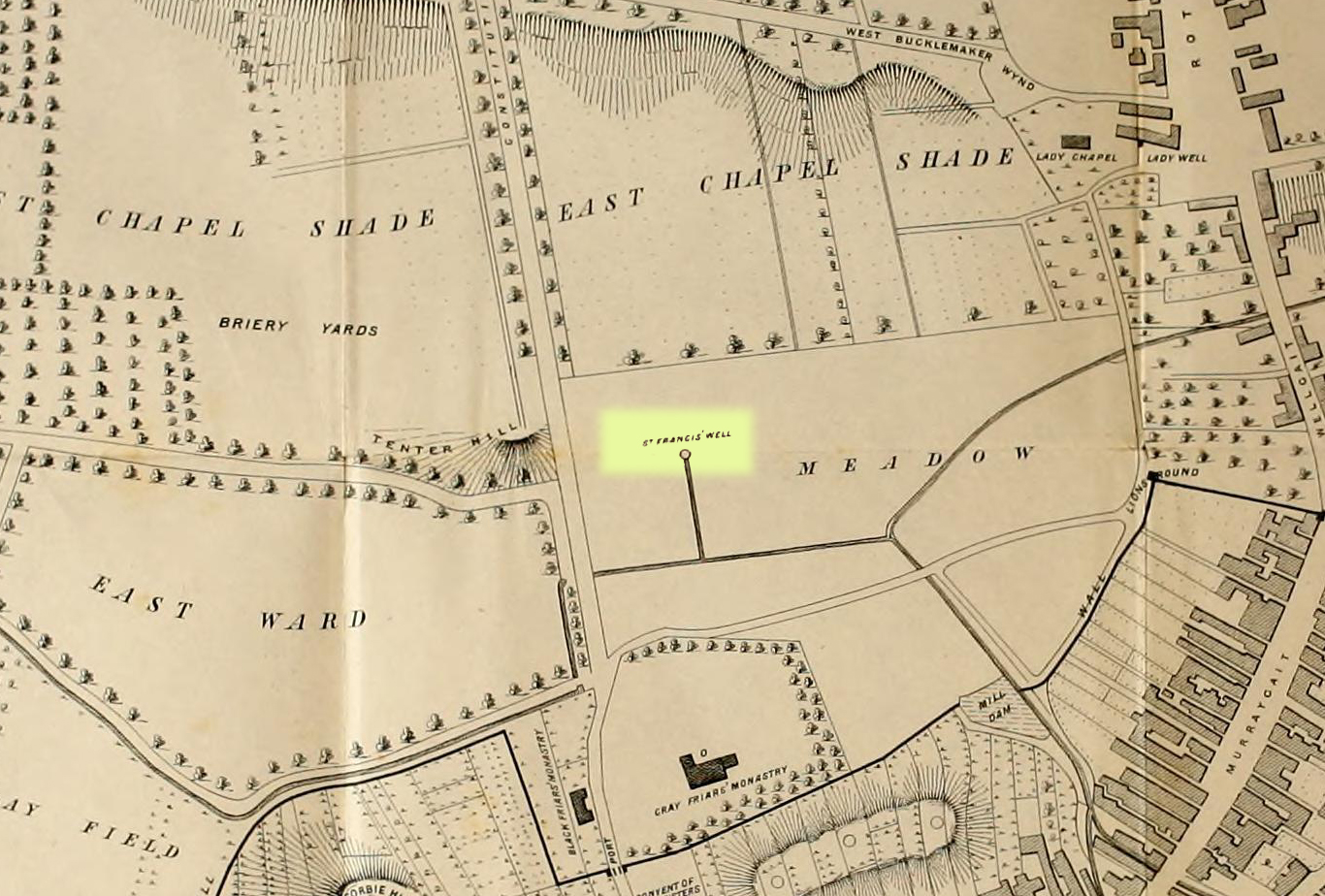
Site shown on 1776 map
This is another one of Dundee’s lost holy wells (see also the Lady Well, the Nine Wells, St Clement’s Well, St Mary’s Well and Sinavey Well), around which the town was first built. Its cold fresh waters were located less than a hundred yards north of the old Houff graveyard in the middle of town, or where Alex Maxwell (1884) described as upon “the sunny slopes of the Gray Friars’ meadows.”
Maxwell told us that this sacred site was the most favoured of the the holy wells in the area, having been dedicated to St Francis of Assisi by the monks who built the medieval Grey Friars monastery, whose ruins lie beneath the Houff graveyard. After the destruction of the priory in the 16th century, the holy well and surrounding meadows came under the ownership of the local council. The well had become ruinous and so was repaired back to its old condition, but a few decades later had become very neglected again and was ordered to be closed. It was mentioned in several early land rental documents, including this from 1630 which told,
“That haugh or meadow lying on the south side of the Tentour Hill, and on the east side of the meadow called Monorgan’s croft, togidder with the lands lying about St. Francis’ well, were set for the yearly penny mail of fifty-ane pounds.”
The most extensive description of it came from Alex Maxwell’s own pen, and I reproduce it here in full. He began by speaking of the other holy wells of Our Lady and St. Clement’s in Dundee, but told us that,
“The most important of them was the Gray Friars’ well, which came out of the rising ground westward from where the High School is built, and had been dedicated to the honour of St. Francis, the founder of the order — a man of exalted character, whom Dean Milman calls “most blameless and gentle.” The water, which ran perennially and was of singular purity, had no doubt been highly venerated in the days of the old Church, and it continued to be much esteemed, and even to maintain somewhat of its traditional sanctity, long after the memory of the good man whose name it bore had become forgotten.
“When the Friars’ house was in ruins, and the gardens laid waste, St. Francis’ well did not escape unharmed. One austere iconoclast—James Patrie was his name—had probably been offended at its sculptural reminiscences of the old faith, and he cast it down. When arraigned to answer for this,
“he confest and grantit that he took down the common well callit the Friar well, quhilk servit the haill town with guid and wholesome water, and referrit him in the Bailies’ and Council’s will thereanent; and they being advisit with his offence, declarit that he sail pay for the reparation of the said well and common warks the soum of ten pounds; always, gif he big and repair the well as Weill as it wes of before with lime mortar, or Pasch next, this pain to be remitted; otherwise, the day past and the well nocht biggit, to pay the said soum but favour.”
James, however, proved contumacious; the day did pass, and the well still lay in ruins. But he got further time, for the Council not yet having possession of the monastic lands, had not chosen to act arbitrarily, and
“James Patrie was ordained to repair the Friar well conform to the last act, under the pain contenit thereintil, betwix the date hereof and Whitsunday;”
and he probably then proceeded to restore it into good condition, as we do not find any other ordinance on the matter. He had not, however, erected it very substantially; for, before thirty years had elapsed, the structure was again ruinous, and the Council resolved
“that St. Francis’ well be of new biggit and made close, so that na common access be had thereto.”
“The meadow land of the Gray Friars which lay around the well, formed a pleasant open space for the use of the old burgh, and it was always held in much regard. Early in last century, the water from the Lady well was impounded and conveyed in pipes for supplying other cisterns throughout the town ; but St. Francis’ spring, which was softer and purer, was left undisturbed to flow down the grassy slope in its natural course ; and when the place became appropriated for homely purposes, and upon
“Its verdant braes,
The lasses used to wash and spread their claes,”
“the gossiping naiads made the meadow very lively as they plashed in the brimming basins of the Friars’ old well, or filled their pitchers at the fresh fountain, or sprinkled the water in crystal showers over their snowy linen. About the time that the ground was sacrificed for the erection of buildings, a dyer in the neighbourhood sank a well which evidently reached the source of the spring and drained it off. Years afterwards, when the place had been overbuilt, he ceased to use his well, and the stream, returning to its old course, found access into the lower part of a church which now covers the site of the fountain, much to the dismay of the deacons. The water was then carried off elsewhere, and will be seen no more ; and the remembrance of those virtues which belonged to the once famous well will soon have passed away.”
In Christian lore, St Francis’ festival day was October 4.
Holy Well (destroyed): OS Grid Reference – TA 026 223
Archaeology & History
This curiously-named, lost holy well was to be found somewhere between the old terrace at West Field and the old road of West Acridge, but even when Henry Ball (1856) wrote about it, the site had passed into history. He told that,
“In the old enclosures to the west of the town was a spring of clear water called St. Trunnion’s well, and in a field in the West Acridge a very old thorn tree called St, Trunnion’s tree, which was standing in 1736; but who St. Trunnion was is not known…”
The close proximity of the tree with the well is highly likely. Throughout the British Isles there are many relationships where sacred trees and wells of the same name are next to each other and we have little reason to doubt this was the case here. However, unless local historians can uncover some old field-name maps, the exact location of the site seems to have been lost. It was named as St Tronians in 1665; with his sacred tree mentioned in early enclosure awards dated 1681 and 1697 respectively.
The enigmatic saint ‘Trunnion’ is thought to derive, not from some old hermit or heathen holy dood, but from the corruption of an early word: “a perversion of Trin-union or Tri-union, used as an asservation or oath”; although another option cited by Cameron (1991) is that it derives from “trinune, trin-une, referring to the Trinity”—which would explain the sanctification of the waters.
Holy Well (destroyed): OS Grid Reference – TA 032 222
Archaeology & History
Not far from the middle of this small town there lived, many centuries ago, a sacred spring of water dedicated to St. Catharine. Described in local field-names from 1697 (as St. Catherin’s Well), all trace of it has long since vanished. Indeed, even when Henry Ball (1856) wrote about it, local knowledge of it had already fallen into obscurity. He could merely tell us that,
“At the end of Newport, in what was called “the Colony,” was St. Catharine’s Well, and the road from thence to Finkle lane was named Catharine street.”
Folklore
St Catharine’s festival date—known as Cattern Day in some parts of England—is November 25.
Holy Well (destroyed): OS Grid Reference – NT 2523 4045
Archaeology & History
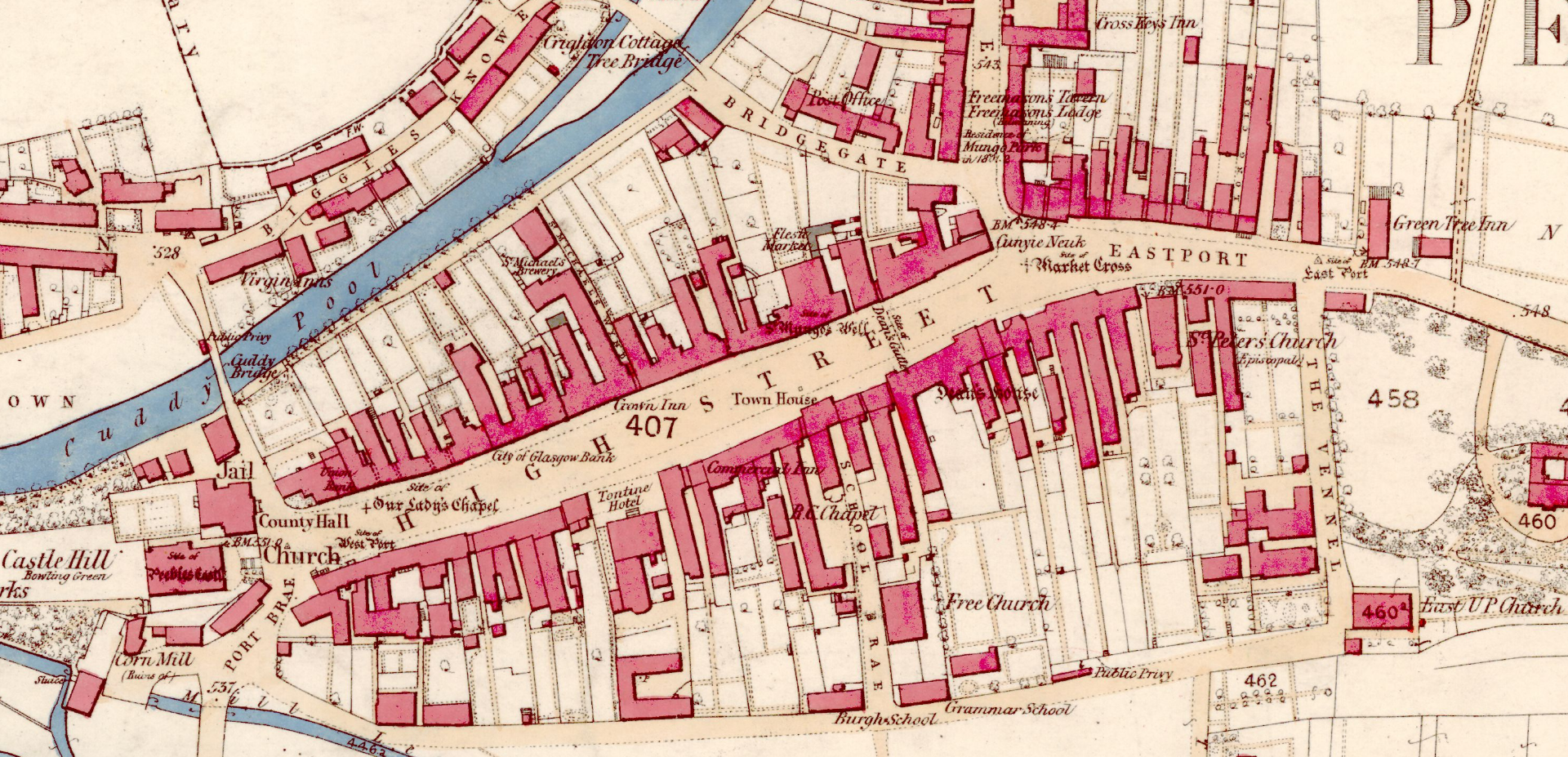
St Mungo’s Well, 1858 map
Highlighted on the 1858 OS-map, two-thirds the way up the High Street, this long forgotten sacred well was described by the Ordnance Survey lads in their Name Book (1856) as “an excellent spring”—and no doubt an ever-flowing one, even in the greatest of droughts. But it had already been destroyed when they came here. It was mentioned in passing by William Chambers’ (1856), who described it as a “public fountain” dedicated to old Mungo, a.k.a. St Kentigern. But its position in the High Street wasn’t where it originally emerged. Local tradition told it was once on the slopes of Venlaw immediately north of the town, possibly making it into the folklore category of “Wells that Move”—usually because the spirit of the place has been offended.
But in truth, little is known about its mythic history. Its origin seems, as with so many ancient sites, entangled in what Dr Gunn (1908) in his definitive work on the history of Peebles church explained, the heathen “superstitious regard for fountains”, pre-dating the christian dedications. St Mungo himself, said Gunn,
“is remembered in Peebles to-day by his holy well upon the slopes of Venlaw, hallowed by its use in the Sacrament of Baptism.”
It’s profane history tells simply that, in 1728, its waters were piped into the trough on High Street for public use. It became damaged sometime in the early 19th century, but some remains of the stonework were found when roadworks were done here in 1845. It would be good if we could recover further information about this important holy well.
References:
Chambers, William, A History of Peeblesshire, W. & R. Chambers: Edinburgh 1864.
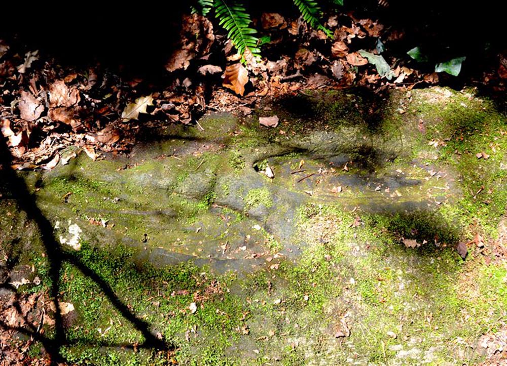
St Columbkille’s place in Irish history was considerable and, said Maghtochair (1867), he was said to have “founded more than one hundred churches and religious houses.” His feet, also, have been carved or burned into a number of rocks scattering the Irish landscape. Not to be confused with his ‘feet’ that are carved near Londonderry, the ones here have been classed in the archaeological inventories as a bullaun and, wrote Brian Lacy (1983) in the Donegal Archaeological Survey, can be found on,
“A 2m long ledge of rock outcrop containing two depressions, c.0.33m in diameter x ).1m deep. They are known locally as St. Columbkille’s footprints.”
As can be seen in the above photo, the ‘footprints’ seem to have been artificially outlined at some time long ago, to make them more notable.
References:
Lacy, Brian, Archaeological Survey of County Donegal, Donegal County Council 1983. p.307
Maghtochair, Inishowen – Its History, Traditions and Antiquity, Journal Office: Londonderry 1867.
Sconce, James, “Cup-Marked Stones,” in Transactions of the Edinburgh Field Naturalists, volume 5, 1907.
Swan, Harry Percival, The Book of Inishowen, William Doherty: Buncrana 1938.
Acknowledgements: Big thanks to Catherine, of the We Love Donegal website.
Holy Well (destroyed): OS Grid Reference – SE 2894 3382
Archaeology & History
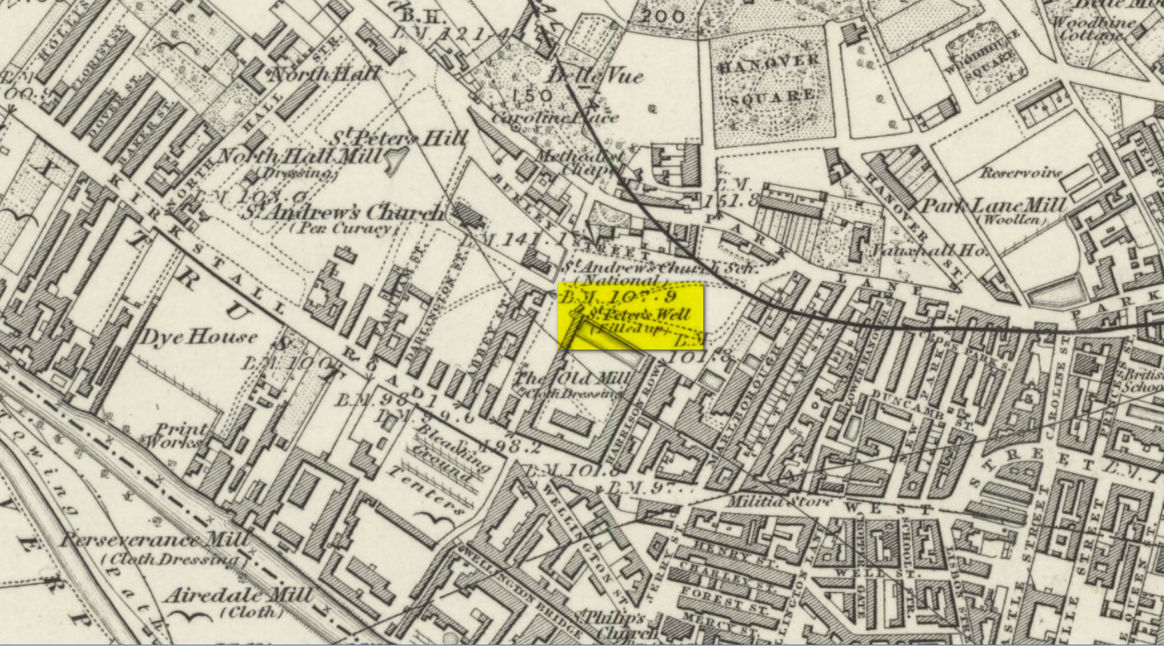
St Peters Well on 1852 map
Not to be confused with the other St. Peter’s Well that once existed in the city centre, this site was shown on an 1815 map of Leeds (which I’ve not been able to get mi hands on!), known as the Waterloo Map. But when the Ordnance Survey lads visited the place in 1846, it had been covered over. Immediately west of here, the saint’s name was also given to a nearby hill, whose folklore seems has been forgotten.
Although Ralph Thoresby mentioned it in passing, Edward Parsons (1834) gave us a brief description of its qualities, telling us that,
“Near North Hall is the celebrated spring called St. Peter’s Well ; the waters are so intensely cold that they have long been considered very efficacious in rheumatic disorders.”
Bonser (1979) reiterated this in his survey, also telling that, like its nearby namesake, its waters were “intensely cold and beneficial for rheumatism, rickets, etc.” An old bathing-house that was “annexed to the Well” may have been used specifically to treat such ailments, but we cannot say for sure.
Interestingly, Andrea Smith (1982) told that 400 metres away a well was sunk in 1838 and a quantity of petrified hazelnuts were recovered from a broken red jar which had a female head painted on it. Such a deposit is not too unusual, as a number of sacred wells in bygone days were blessed with nuts and signified the deity Callirius, known by the Romans as Silvanus, the God of the Hazel Wood – though we have no direct tradition here linking St. Peter’s Well with this ritual deposit.
St. Peter’s festival date was June 29.
References:
Bonser, K.J., “Spas, Wells and Springs of Leeds,” in The Thoresby Miscellany – volume 54, Leeds 1979.
Hope, Robert Charles, Legendary Lore of the Holy Wells of England, Elliott Stock: London 1893.
Parsons, Edward, The Civil, Ecclesiastical, Literary, Commercial and Miscellaneous History of Leeds, Halifax, Huddersfield, Bradford, Wakefield, Dewsbury, Otley – volume 1, Frederick Hobson: Leeds 1834.
Smith, Andrea, ‘Holy Wells Around Leeds, Bradford & Pontefract,’ in Wakefield Historical Journal 9, 1982.
Holy Well (destroyed): OS Grid Reference – TL 10302 30328
Also Known as:
Hertfordshire Historic Environment Record No. 1926
Archaeology & History
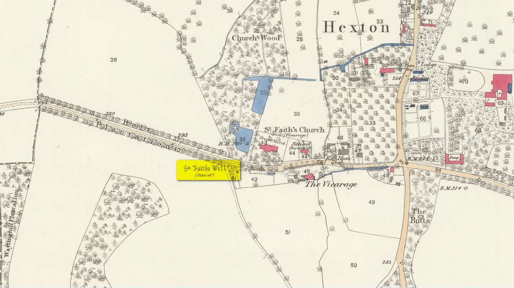
The site of the well is now in the garden of a house on the south side of the B655 Barton Road in Hexton, south west of St Faith’s church. Prior to the Reformation, there was a small chapel of St Faith adjacent to the well containing a shrine to the saint, which was, with the well a place of pilgrimage.
N. Salmon, writing in 1728, told us:
St Faiths Well on 1882 map
“At Ravensborough, within a Quarter of a Mile, is a fine Spring, which runs down to Hexton, and meets there another Stream rising at the Berystede near the church, which is indeed a very remarkable one. It comes pouring out of the Earth in such plenty, that it would turn a Mill in a very little Way; and hath been since the Roman Times thought worthy of a Saint’s Name. It was called St Faith’s Well, to which the church also is dedicated, and the Image of St Faith was placed over it.”
The well is just to the north of the iron age hill fort of Ravensburgh and near the ancient prehistoric roadway of Icknield Way, so would certainly have been a welcome stopping point for prehistoric travellers in these chalk uplands. In line with Salmon’s contention of its having been known since Roman times, Francis Taverner, the 17th century Lord of the Manor of Hexton wrote of the well having been used for oracular purposes by people who would throw an object onto the surface of the water:
“which if swamme above they were accepted and there petition granted, but if it sinke, then rejected which the experienced Prieste had arts enove to cause to swymme or sinke according as himselfe was pleased with the partye, or rather with the offering made by the partye.”
St Faith who was a third century martyr who was beheaded at Agen in Gaul. Her saint’s day is 6th October, and her patronage was invoked inter alia by pilgrims, so the dedication of the well and nearby church may have been to ‘christianise’ a pre-existing oracular place resorted to by travellers on the Icknield Way.
Taverner again:
“There is a small parcel of ground adjoining the churchyard called “St. Ffaith’s Wick Court,” about a pole in measurement, anciently divided from Malewick by a ditch in the same place where now a large moat is made. The greatest parte of this Wick lying upon a bedde of springs, and undrained, was very boggye towards the churchyard; but the west side being higher, the ground was well planted with oaks, willows, and bushes, near adjoyning unto which, the craftye Priests had made a well about a yard deepe, and very cleere in the bottome, and curbed about, which they called St. Faith’s Well.
“Now over this well they built an howse, and in the howse they placed the image or statue of St. Faith, and a cawsey they had mad (which I found when I digged and levelled the ground) for the people to passe who resorted thither from farr and neere to visitt our Lady, and to performe their devotions reverently, kissing a fine-colloured stone placed in her toe. This Lady was trimly apparelled, and I find in an old book of churchwarden’s accounts, in the reign of Henry VIII, that they had delivered unto the St. Ffaith a cote and a velvet tippet. The Lady had no land to maintain her, that I know of, more than i acre lying in Mill Field, called at this day St. Ffaith’s acre, which, as being given to superstitious uses, came to the King’s hands at the dissolution, and is now parcel of the demesnes. The house being pulled down, and the idol cast away, the well was filled up, yet an apparent mention of the place remained till my time, and St. Ffaith’s Well continued as a waste and unprofitable and neglected piece of land till such time as the footpath was turned through the midst of it to the outside on the south by the highway, and their clearing and levelling the ground, having been drained, and sunk the spring, I converted the same, in the year of our Lord 1624, into a little orchard. The Lady Ffaith was a Virgin and Martyr of Agenne, in France, a.d. 1290.”
The well may have had healing properties too. Herbert Tompkins (1902) informed us how,
“…to folk who have never stepped out of Hertfordshire (I have known several such) the well of St. Faith is indeed the “Well at the World’s End.” The waters of that well were of miraculous efficacy, and an image of its saint was long preserved in the chapel of St. Faith Virgin, of which no stone remains.”
The parish church of Hexton remains dedicated to St Faith , as does the parish church of nearby Kelshall. There was another St Faith’s Well at Leven in East Yorkshire.
References:
Clutterbuck, Robert, History & Antiquities of the County of Hertford – volume 3, Nichols Son & Bentley: London 1827.
Farmer, David Hugh, Oxford Dictionary of Saints, Oxford University Press 1987.
Hippisley-cox, R., The Green Roads of England, 6th Edition, Methuen: London 1948.
Hope, Robert c., Legendary Lore of the Holy Wells of England, Elliot Stock: London 1893.
Johnson, Walter, Folk Memory or the Continuity of British Archaeology, Clarendon Press: Oxford 1908.
Jones-Baker, Doris, Old Hertfordshire Calendar, Phillimore: Chichester 1974.
Salmon, N., History of Hertfordshire, London, 1728.
Tompkins, Herbert W., Highways & Byways of Hertfordshire, Macmillan: London 1902.