Priest’s Stone, Lethnot & Navar, Angus

Standing Stone (destroyed):  OS Grid Reference – NO 5404 6892

Archaeology & History

Priest’s Stone on 1865 map

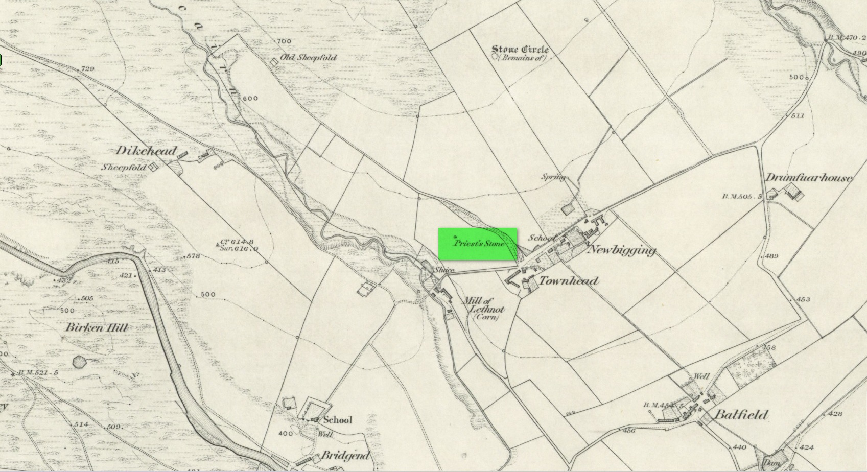
Despite being shown on the early OS-maps of the area, I can find few references this place.  The Ordnance Survey lads themselves, when visiting here in 1863, merely told that this it was “a standing stone of which nothing is known except the name.  It is 3 feet high, three feet in diameter at base, and a foot and a half at top.”  Even in Cruikshank’s (1899) definitive survey of this township he could add little more, merely telling:

“About a quarter-of-a-mile north of Bellhill is a field known as “the Priest’s Field.” There is a large right stone in the middle of it, called “the Priest’s Stone,” and it is so given on the Ornance Survey map. not simply because such is the local name, but also because the skilled surveyors after examining it concluded that it had been used for sacrifice. It stands just behind the site of the old farm steadying of Upper Argeith, or vulgarly, Townhead.”

Quite what he meant by saying that “it had been used for sacrifice,” god only knows!  But the writer was the local minister and so would have been possessed by the usual delusions.  Anyhow, the stone was uprooted and destroyed by the farmer at Newbigging, sometime prior to 1958.  Idiot!

A half-mile north of this could once be seen a stunner of a site: a double-ringed giant tomb from where hundreds of cartloads of stone were taken.  It too no longer exists!

References:

  1. Cruikshank, F., Navar and Lethnot: The History of a Glen Parish in the North-east of Forfarshire, Black & Johnston: Brechin 1899.
  2. Royal Commission on the Ancient and Historical Monuments of Scotland, The Archaeological Sites & Monuments of Central Angus, Angus District, Tayside Region, HMSO: Edinburgh 1983.

Acknowledgements:  Huge thanks for use of the Ordnance Survey map in this site profile, reproduced with the kind permission of the National Library of Scotland

© Paul BennettThe Northern Antiquarian

Holy Priests’ Well, York, North Yorkshire

Holy Well (destroyed):  OS Grid Reference – SE 6071 5187

Archaeology & History

At the beginning of the 19th century, William Hargrove (1818) described the scant remains of some old walling along old Haver Lane (renamed as Green Lane and now known as The Stonebow) which were the remains of a building, long gone, and which,

“tradition informs us (was) a religious house, which formerly stood here, called Holy-Priests; and though the site of it is not known, the report is greatly strengthened by the appearance of the walls just mentioned, and by the circumstance of a deep draw-well which now remains, being still called Holy-Priests Well.”

Some suggest that this water source may still exist beneath one of the buildings hereby, but the landscape here has been so badly mutilated over the last two hundred years that it’s very unlikely.

References:

  1. Hargrove, Willliam, History and Description of the Ancient City of York – volume 2, part 2, W. Alexander: York 1818.

© Paul BennettThe Northern Antiquarian

Priest’s Well, Glasgow, Lanarkshire

Holy Well (destroyed):  OS Grid Reference – NS 6029 6547

Also Known as:

  1. Minister’s Well

Archaeology & History

Site of the Priests Well in 1865

A ‘holy well’ with a bit of a difference when it was designated as such, however many centuries ago.  Found on the southern slopes below Glasgow ‘s Cathedral, just a few yards west above the Molendinar Burn (upon which Wishart Street now sits), this was deemed to be a well only to be used by the christian ministers or priests from above.  Local people were not supposed to drink here it seems!  Instead, they were supposed to either drink from the burn, or walk a short distance down to the Lady Well (now badly polluted) 175 yards to the southeast.  I don’t expect many Glasgow folk paid that much attention to such arrogant ministerial laws!

Shown on the earliest OS-map, simply as a ‘Well’, this is one of at least four water sources within a square mile of the Cathedral (including St. Mungo’s and Lady Well) that were deemed as ‘sacred’.  It truly makes you wonder what on Earth was here before the christians came along and built their huge temple on the rocks above…. What animistic heathen rites and traditions were suppressed around this natural landscape before the toxic blanket of christianity was imposed upon us?

References:

  1. Brotchie, T.C.F., “Holy Wells in and Around Glasgow,” in Old Glasgow Club Transactions, volume 4, 1920.
  2. MacGeorge, Andrew, Old Glasgow, Blackie & Son: Glasgow 1880.
  3. MacKinlay, James M., Folklore of Scottish Lochs and Springs, William Hodge: Glasgow 1893.

© Paul Bennett, The Northern Antiquarian