Follow the same directions for reaching the Baldwin Stone. From here, with your back to the wall, face the small remnants of Robin Hood’s Wood and walk straight to where the game-keeper’s stuff is in the trees 150 yards straight in front. Go through the small copse and out the other side, in a straight line for another 70 yards. This stone’s mainly covered over with vegetation (and we covered most of it back over again) so you might have trouble finding it. But with patience and a good nose, you’ll find it hereabouts!
Archaeology & History
Robin Hood’s Wood Cup-Marks
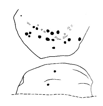
Another previously undiscovered carving, found yesterday (12.6.09) by Michala Potts after rummaging for sometime amidst the mass of Juncus grasses which cover the plain immediately north of Robin Hood’s Wood. Not much to see unless you’re a real rock-art freak, as we only have two definite cup-markings on the stone. A possible third cup can be seen closer to the NW edge, where the rock becomes more crystalline.
I was rather intrigued by Mikki’s find, as when she shouted me over, found that she’d rolled much of the vegetation back that had been covering the stone. Without rolling the grasses back from the surface, she wouldn’t have found the cup-marks; and considering the number of stones that scatter this plain, I asked why she’d chosen to uncover this one and not the others.
“It told me to!” she said in that blunt Yorkshire way.
Follow the same directions to reach the nearby Wondjina Stone, but as you reach the trig-point at the top of Rivock Edge, note the smooth rounded boulder 50 yards ESE. That’s it!
Archaeology & History
Named after the sea of cotton grasses, or niplets (Eriophorum angustifolium), amidst which it lives for several weeks of the year, the cups-marks that make up this design can be terribly difficult to work out even in the best of lighting. We have here a lichen-encrusted stone with perhaps as many as 25 cup-marks scattering, mainly, the top and westerly sloping face. Although some of the cups are quite noticeable, the vegetative growth and simple erosion has made an accurate visual impression of the original carving very difficult — as the images plainly tell! If I ever manage to capture the stone resting in a good mood, I’ll replace the photos I’ve got here!
Niplet Stone, looking SEBeautiful fusion of faded cups, lichen & great age…
Although I remember coming here and seeing this and the nearby carvings when I was a teenager, then a few years later on with Edna Whelan and Graeme Chappell, it seems that the first literary note of this carving after my own initial exploration was in the Ilkley Archaeology Group’s survey (Hedges 1986), where they make note of a flint that was found beside the stone. Boughey and Vickerman (2003) later include the same stone in their work, but with no additional information.
References:
Bennett, Paul, “The Prehistoric Rock Art and Megalithic Remains of Rivock & District (parts 1 & 2),” in Earth, 3-4, 1986.
Boughey, Keith & Vickerman, E.A., Prehistoric Rock Art of the West Riding, WYAS 2003.
Hedges, John (ed.), The Carved Rocks on Rombald’s Moor, WYMCC: Wakefield 1986.
From East Riddlesden, go up the road (over the swing-bridge) that takes you onto the moor-edge (ask a local if you have trouble). Go all the way up till you hit the road which encircles the moor (it’s called the Silsden Road where you hit it). Turn left for several hundred yards till you see the microwave tower just on the hillock to your right on Pinfold Hill (not the larger TV towers just below the forest). Walk up there, then follow the edge of the walling till you hit the old Pinus sylvestris trees of Robin Hood’s Wood where 2 walls meet. Go over the gate and walk to your right for about 200 yards, following the line of the walling. You’re there!
Archaeology & History
Cluster of cups on W edge
A newly-discovered cup-marked stone, located for the first time on Tuesday, June 9, 2009, by Michala Potts, who was out on an amble with some long-haired halfwit whizzing about getting excited about stupid cup-markings on stones, dragging her back and forth and leaving her in the middle of a bog! On one occasion when this ‘ere fruitbat wandered off (again!), leaving her alone in the middle of the hills, she decided to check out some rocks a bit further up the slope where she’d been left alone. And there, along the edge of some walling, right on the edge of the much-denuded Robin Hood’s Wood, a short distance west of Rivock, a curious stone popped out and caught her attention!
Was this a cup-marking she saw before her!? It certainly was! But she didn’t call out to this halfwit who’d left her to her own devices. She let him just wander off to his sad heart’s content, whilst she got into the nitty-gritty of checking the stone out, uncovering the essentials of the carving while he bimbled off like a freak! And what a nice carving it was she found…
Baldwin Stone – looking westFirst sketch of the stone
Although no accurate measurements were made of the stone (it was bigger than 10-inch!), at least 17 cup-markings were counted here: one singular and very well-preserved cup, alone on its southern edge, right by the walling. But the main feature of the design is a cluster of cup-marks (at least 11) on the western side of the rock — one part of this cluster having the appearance of the figure 5 on a dice! Several other well-defined cups occur on the central and more northern end of the rock.
Eventually, her sad stone-wandering fella returned, forlorn, having found no new carvings of his own (poor soul!). And so she took his poor little hand, and took him to see the little prehistoric treasure she’s uncovered — and her sad little man got all smiley and … well, you know what they’re like!
Additionally however, for the archaeo’s amongst you: if you come wandering up here to check this carving out, you’ll notice the remains of many large upright stones in a lot of the old stone walls round here. Many of these are the remains of Iron Age walling.
Take the same directions as to reach the Snowden Crags Necropolis, and where the small rounded hill rises up on the eastern end of the plain, look around and you’ll find the stone in question.
Archaeology & History
Up near the edge of the Snowden Moor settlement, just a few yards away from Carving-570, is this medium-sized earthfast boulder with what seems to be three or four cup-markings on its western-face. Boughey & Vickerman (2003) describe the stone as with a “deep gully, cups and enlarged cup, perhaps weathered carving but could be natural” — which seems a reasonable assessment. Certainly the cups seem weathered, although a couple of them may have been man-made. At the side of the rock are the remains of a small cairn, and it is positioned next to the beginning of the Snowden Moor Cemetery.
References:
Boughey, Keith & Vickerman, E.A., Prehistoric Rock Art of the West Riding, WYAS 2003.
Cowling, Eric T., Rombald’s Way: A Prehistory of Mid-Wharfedale, William Walker: Otley 1946.
From the village of Midgley, high above the A646 Halifax-to-Todmorden road, travel west along the moorland road until you reach the sharp-ish bend in the road, with steep wooded waterfall to your left. From here, across the road (roughly) there’s a track onto the moor. Go up this, keeping to the line of the straight walling uphill by the stream-side (instead of following the path up the quarries) all the way to the top. Here you’ll see the boundary stone of Churn Milk Joan. Take the footpath to its side for up onto the moor 250 yards or so, taking a right turn into the deeply cut footpath and walk along for several hundred yards, keeping your eyes to the north (right). You’ll see the rocky cairn of Miller’s Grave not far away in the heather, near to the large rounded boulder known as Robin Hood’s Pennystone.
Archaeology & History
Ascribed by some as neolithic, and others as Bronze Age (the more probable), here is a curious archaeological relic: curious, inasmuch as it’s received very little attention from archaeologists. It’s quite a large monument — and perhaps the fact that it has always seemed to be in isolation from other prehistoric remains has held it back a little. But recent ventures here have brought about the discovery of more cairns (though singular small ones), neolithic walling, hut circles and other prehistoric remains that have never previously been reported.
Miller’s Grave, Midgley Moor (in VERY heavy rain!)Central stone aligning north to Nab End
It’s a decent site aswell. Mainly consisting of the usual mass of smaller stones piled up and around one main point; in the middle of this ‘tomb’ is a large split glacial erratic boulder, which may have been the original focus of the builders. Some may even ascribe a coupla cup-markings on this ‘ere central rock form — but they’d be pushing it a bit! This large central feature aligns to the high peak of Nab Hill several miles north, above Oxenhope. Whether this feature was of any significance in the cairn’s construction is debatable (though as north represents death in pre-christian peasant lore, this ingredient has to be noted).
Profile shot – looking NELooking SE, with small cairn in foreground
The cairn is a goodly size: some 4 feet tall and about 50 foot across at its greatest diameter. Some of the stones near the centre of the stones have been put there in more recent years. In previous centuries, treasure-seekers came here in the hope that they’d uncover gold or other trinkets and stripped off much of the original cover, moving many rocks to the edges. Others were also stolen from here to make some of the grouse-butts, not far from away. In a foray to the site on 5.9.10. we were lucky to find the heather had been burnt back and found, some ten yards to the north and to the southwest, the remains of small, outlying singular cairns (though these need excavating to ascertain their precise nature).
Calderdale Council’s archaeology notes on Miller’s Grave tell it to be “situated on the summit of Midgley Moor”, which is quite wrong. The summit of the moor is some distance west of here, near where an old standing stone called the Greenwood B stone (75 yards south of the Greenwood Stone) and the much denuded remains of other prehistoric sites could once be found — though I’m not sure that they, nor the regional archaeologist for Upper Calderdale has ever been aware of them.
Folklore
In F.A. Leyland’s (c.1869) extensive commentary to Watson’s History of Halifax (1775), he relates a fascinating tale which seems to account for the name of this old tomb:
“About ninety years ago,” he wrote, “that is, towards the end of the eighteenth century – one Lee, a miller, committed suicide in Mayroyd Mill near Hebden Bridge. The jury at the inquest held on the occasion returned a verdict of felo-de-se, and the body was buried at Four Lane Ends, the Rough, in Midgley. The fact, however, of the body of one who had laid violent hands upon himself, lying in unconsecrated ground at a point where the highways met, and at a spot which the inhabitants passed early and late, oppressed the people of the neighbourhood with an irresistible dread. Persons going to market and passing from village to village, feared and avoided the unhallowed spot, until the feeling increased to one of insupportable terror; and, in the night time, a multitude collected with torches to disinter the body. This was speedily effected and violence was even offered to the dead. A man named Mark Sutcliffe, and others, who attempted to prevent the exhumation, were stoned* by the mob, and the body was hurried to the cairn on Midgley Moor, where it was hastily interred. Here however, it was not allowed to rest; the isolation of the body, though buried in a lonely spot, was yet apart from the common cemetery where the dead lie together in their special domain; and this invested the surrounding district with a superstitious awe difficult to describe. The body was still too near the haunts of the living; and, to the perturbed imagination of the inhabitants, the unquiet ghost of the suicide constantly brooded over the hills. As this was not to be endured, the body was at last removed from the cairn, and finally buried in the churchyard of St. Thomas a’ Beckett’s, Heptonstall. Although the interment of Lee, at the cairn, has conferred upon the spot the name of the Miller’s Grave, it cannot be doubted that the large quantity of heavy stones which we find heaped together at this place…was piled up in distant times…”
Modern pagan folklore ascribes the name of this site to relate to Much, the Miller’s Son: acquaintance of the legendary Robin Hood, whose ‘Penny Stone’ boulder is just 100 yards west of here.
Follow the directions for getting to the great Badger Stone carving. From here, walk eastwards on the footpath for about 400 yards. Hereabouts walk off the path and down the slope just a few yards and amble back and forth, checking the various stones. Keep doing this until you find it! (luckily, this stone’s marked on the OS-map) There are several other reasonable carvings nearby on the same plain…the Green Gates Stone (or carving no.257) for one!
Archaeology & History
The Pitchfork Stone (after Hedges, 1986)
First found (or rather, recorded) by our old friend Stuart Feather and described in Bradford’s Cartwright Hall Archaeology Group’s Bulletin in 1961. It’s status was all-but-secret until Hedges edited the Ilkley Archaeology Group’s Carved Rocks work in 1986. The stone’s a simple design as the illustration shows: an urn-like vessel with a cup in the middle; but the attached groove at the bottom gave one anonymous chap (who dared to use the modern name of RombaldII!) the idea of it looking like a pitchfork – so the name sticks!
The enclosing “lines” that make up the pitchfork aspect of the carving are pretty enhanced (as we can see in the photograph here) and may, just may, be the result of a more recent petroglyphic artist.
References:
Boughey, Keith & Vickerman, E.A., Prehistoric Rock Art of the West Riding, WYAS 2003.
Feather, Stuart, ‘Mid-Wharfedale Cup-and-Ring Markings – Nos. 2 & 3, Ilkley Moor,’ in Bradford Cartwright Hall Archaeology Group Bulletin, 6, 1961.
Hedges, John (ed.), The Carved Rocks on Rombalds Moor, WYMCC: Wakefield 1986.
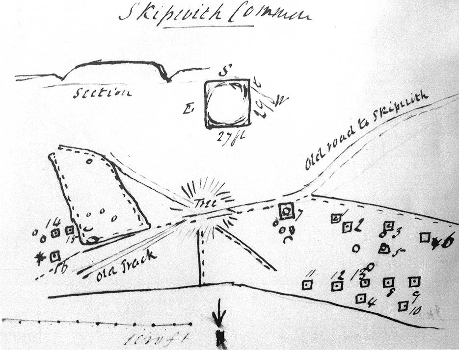
Travelling up (north) the A19, just as you get to Riccal village, there’s a small road to your right: take this! A mile along there’s a parking place just where the track veers into the woods. That’s where you’re heading. The remains of the tombs hereabouts can be hard to discern – but if your lucky you’ll either meet a local, or the virtue of patience will bring these overgrown tombs into focus! There are other tumuli a few hundred yards east and north of here aswell. If you wanna get a clear picture of them all, a full day would be a good bet!
Archaeology & History
Not to be confused with the other Danes Hills tombs a couple of miles northeast of here (as done on some other sites), the early Victorian geologist and explorer John Phillips (1853) was one of several early writers who described what, today, are known to be Iron Age tombs, scattered about a short distance east of Riccall village, saying:
“On Skipwith Common are many tumuli, old banks, and the slightly-marked foundations of ancient (turf or log?) houses or wigwams. These, by some error of tradition, are called ‘Danes’ Hills/ but, on opening the tumuli, no confirmation of so modern a date appeared. The tumuli are set in square fosses; the sides of the fossae range north and south and east and west (true). Similar facts appear in connexion with the tumuli on Thorganby Common adjacent. Burnt ashes and bones occur in the mounds; facts which suffice to overthrow the supposition of these hills being funeral heaps of the Danes of the llth century, for they then buried their dead. No instruments of metal, bone, or stone, or pottery were found.”
There were dozens of tombs that could be seen here in the past, but today many have been destroyed or are hidden by the cover of trees. A sketch-map (above) showing the rough location of many of the graves was made by the Yorkshire Antiquarian Club after a visit here in 1849 (Proctor 1855), who opened several of the barrows. Archaeologist Ian Stead (1961; 1979) defined these remains as being of the famous La Tene burials — though I’m unsure as to whether any of the tombs here had the great horse-chariots found in them, as found in the more famous Danes Graves tombs close to Driffield.
Folklore
The name of these small hills acquired their Danish title via a mix of real history and folklore. History tells of the old Danish King Harald Hardrada, who moored his fleet of ships a few miles away from here before going into battle against the armies of Northumbria and Mercia. “Dane’s Hill,” said Bogg (c.1895), “still marks the spot where the fight took place.” As John Burton (1758) told us:
“Ever since the aforesaid battle, it is by tradition to this day said, that the Danes were permitted to encamp here till they had buried their dead, and their ships at Riccal should be ready for their re-embarking for Norway.”
Local folk used to tell of the tradition of the local swamp — called Riccal Towdyke — being choked with the bodies of many slain in the battle hereabouts. Many pieces of red cloth were found all around in the neighbourhood of these tombs. However, despite this mix of fact and folklore, the tumuli were see marked on the modern OS-maps have been found to be Iron Age in origin.
…to be continued…
References:
Bogg, Edmund, From Eden Vale to the Plains of York, James Miles: Leeds n.d.
Burton, John, Monasticon Eboracense, N. Nickson: York 1758.
Elgee, F. & H.W., The Archaeology of Yorkshire, Methuen: London 1933.
Morrell, W. Wilberforce, The History and Antiquities of Selby, W.B. Bellerby: Selby 1867.
Phillips, John, The Rivers, Mountains and Sea-Coast of Yorkshire, John Murray: London 1853.
Proctor, W., ‘Report of the Proceedings of the Yorkshire Antiquarian Club, in the Excavation of Barrows from the Year 1849,’ in Proceedings of the Yorkshire Philosophical Society, 1855.
Stead, I.M., ‘A Distinctive Form of La Tene Barrow in Eastern Yorkshire,’ in Antiquaries Journal, volume 41, 1961.
Stead, I.M., The Arras Culture, Yorkshire Philosophical Society: York 1979.
Standing Stone (destroyed?): OS Grid Reference – SE 1765 5032
Archaeology & History
Eric Cowling (1946) described this lost or destroyed stone as “a squat standing stone at junction of the Askwith bridge-path with the Otley-Timble highway, saying how it gave its name to Stoop Hill, “which it surmounts.” But in several ambles here in search of this old stone, we’ve yet to locate it; though we did find the Stoup Hill cup-marking and possible neighbour on the southern edge of the hilltop.
Folklore
In days of olde, the ‘Old Man’ was the fabled companion of the legendary ‘Old Woman,’ or great cailleach (the christian cult stupidly, somehow, turned this mythic figure into their ‘devil’ – to which it has no relationship whatsoever). Although no specific folktale remains here, the name of this lost stone tells that it had some mythic tale underscoring it; perhaps simply that it marked the burial of some forgotten chief or elder.
Very close to being at the top of the island. If you do manage to get here take a gander at the legendary Gulf of Corryvreckan: one of the largest whirlpools on Earth, where the cailleach swirled her stuff when angry! This is the ‘hill where sorrel grows,’ and where George Orwell wrote 1984 – but more important for us is where the Royal Commission for Historic & Ancient Monuments of Scotland (Argyll, vol.5) designated that,
“a stony mound about 5.5m in diameter and 0.5m high, situated on the crest of the ridge east of Barnhill, appears to be a prehistoric burial cairn.”
Sadly I never managed to check this out when I was last up here as I didn’t know it was here!
References:
Royal Commission on the Ancient & Historical Monuments of Scotland, Argyll: volume 5 – Islay, Jura, Colonsay and Oronsay, HMSO: Edinburgh 1984.
Follow the same directions for getting to the Idol Stone, then walk just 30 yards further up the path and it’s the big rock on your left-hand side. Y’ can’t miss it!
Archaeology & History
Main section of cup-marks
This nice big boulder can be quite a temperamental chap, depending on how the light plays with the rock surface. I’ve got some photos of this old stone where you can see next to nowt on it; where as others show clearly aspects of the design that aren’t on the archaeo-images. But such is the nature of cup-and-rings I s’ppose!
Unlike its rather linear companion a few yards away, this great boulder has the more typical scattering of faded cups, lines and at least one cup-and-ring, etched with seemingly little purpose or structural design. But as we know, the very notion of structural design in forms consistent to modern mind-sets were anathema to the neolithic people who were etching these patterns on rocks. Indeed, even the notions of these images as ‘art’ as defined in modern times, has no relationship to the intrinsic reality of either cup-and-rings or reality per se, as experienced by our ancestors. And I think we find an explicit affirmation of this in the Cluster Stone here.
Close-up of cup-and-ring
Natural cuts in the rock have been heightened, for whatever reason, so that today the division between Nature’s marks and the mark of humans have become ambiguous as time has worn the features. The clustering of cup-marks on certain parts of the rock was surely indicative of (what we would term) separate events/forms, whose mythic relationship were, however, intrinscially related. This may be representative of a landscape map, or a series of events – but each would relate to one and other. But, of course, we truly don’t know, so think I’d best shut up!
Cluster Stone design (after Hedges 1986)
The carving itself, as we can see today, has perhaps as many as 40 cup-marks on it (Boughey & Vickerman safely vouch for 26), with five or six lines running across the surface, some of which have been modified by ancient peoples. The cup-and-ring on the stone is quite distinct. Neolithic or Bronze Age walling runs just a few yards away from here, but the precise line it takes has not been accurately assessed.
References:
Boughey, Keith & Vickerman, E.A., Prehistoric Rock Art of the West Riding, West Yorkshire Archaeology Service 2003.
Hedges, John (ed.), The Carved Rocks on Rombald’s Moor, WYMCC: Wakefield 1986.