St. Canna’s Stone, Llangan, Carmarthenshire

Legendary Rock:  OS Grid Reference – SN 1770 1874

Also Known as:

  1. Chair of St. Canna
  2. St Canna’s Chair

Archaeology & History

St. Canna’s Chair Stone

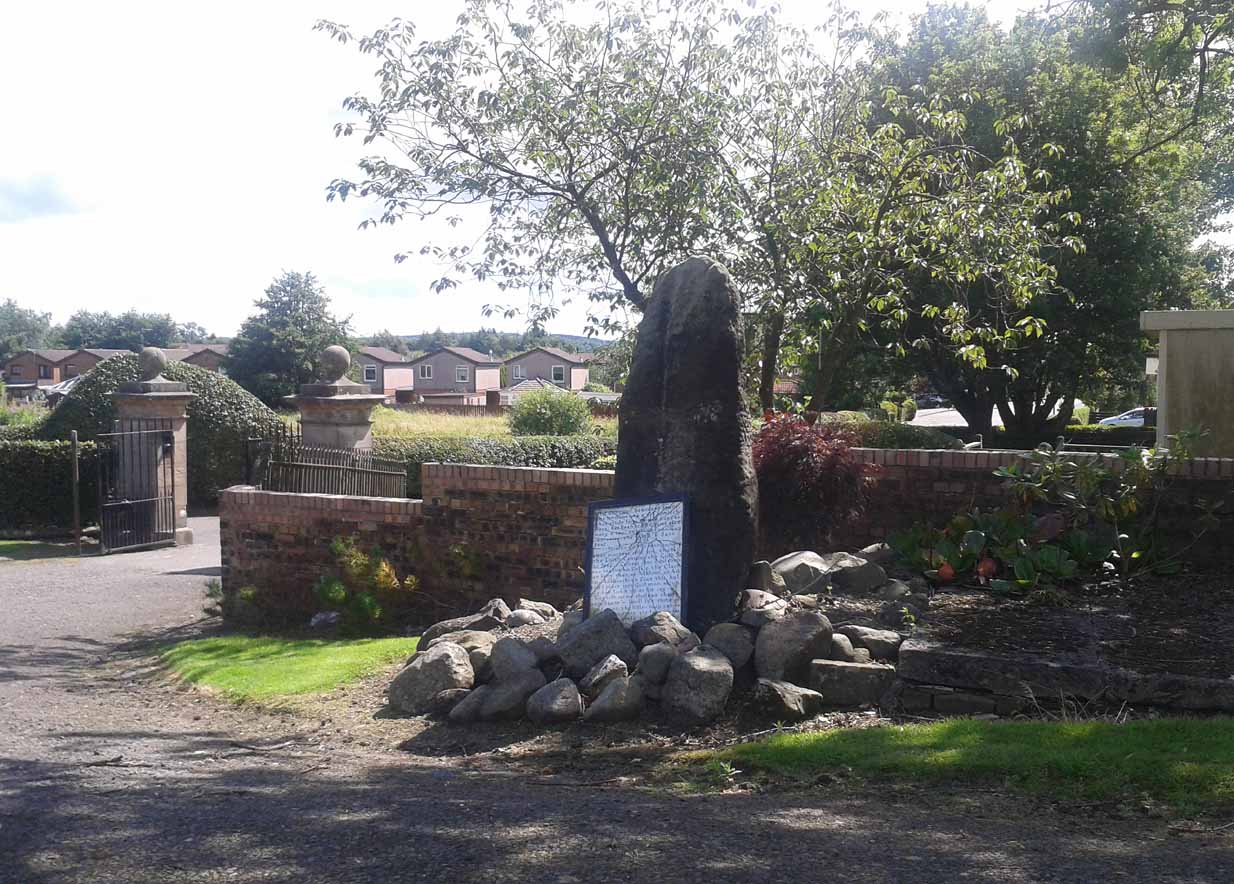
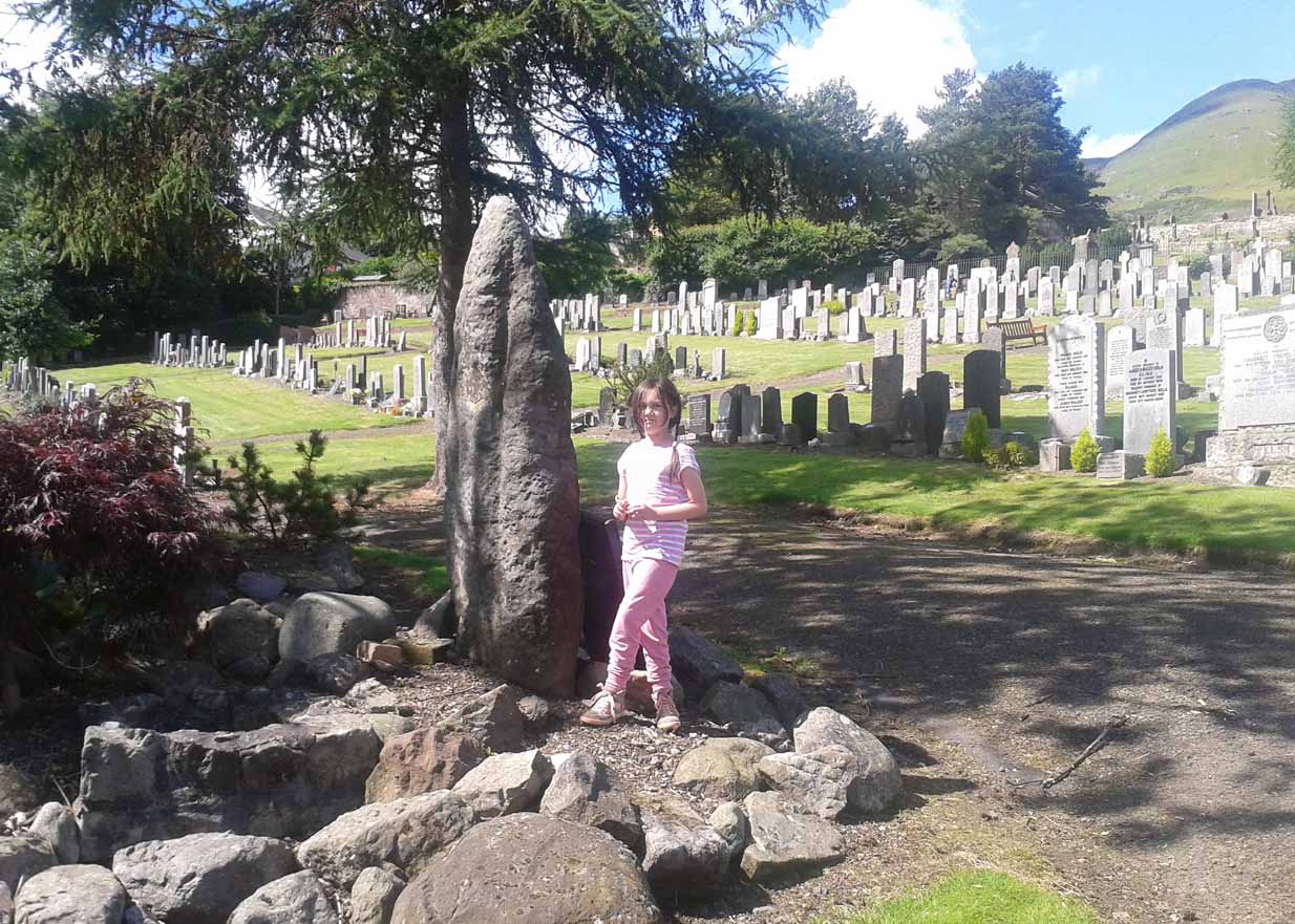
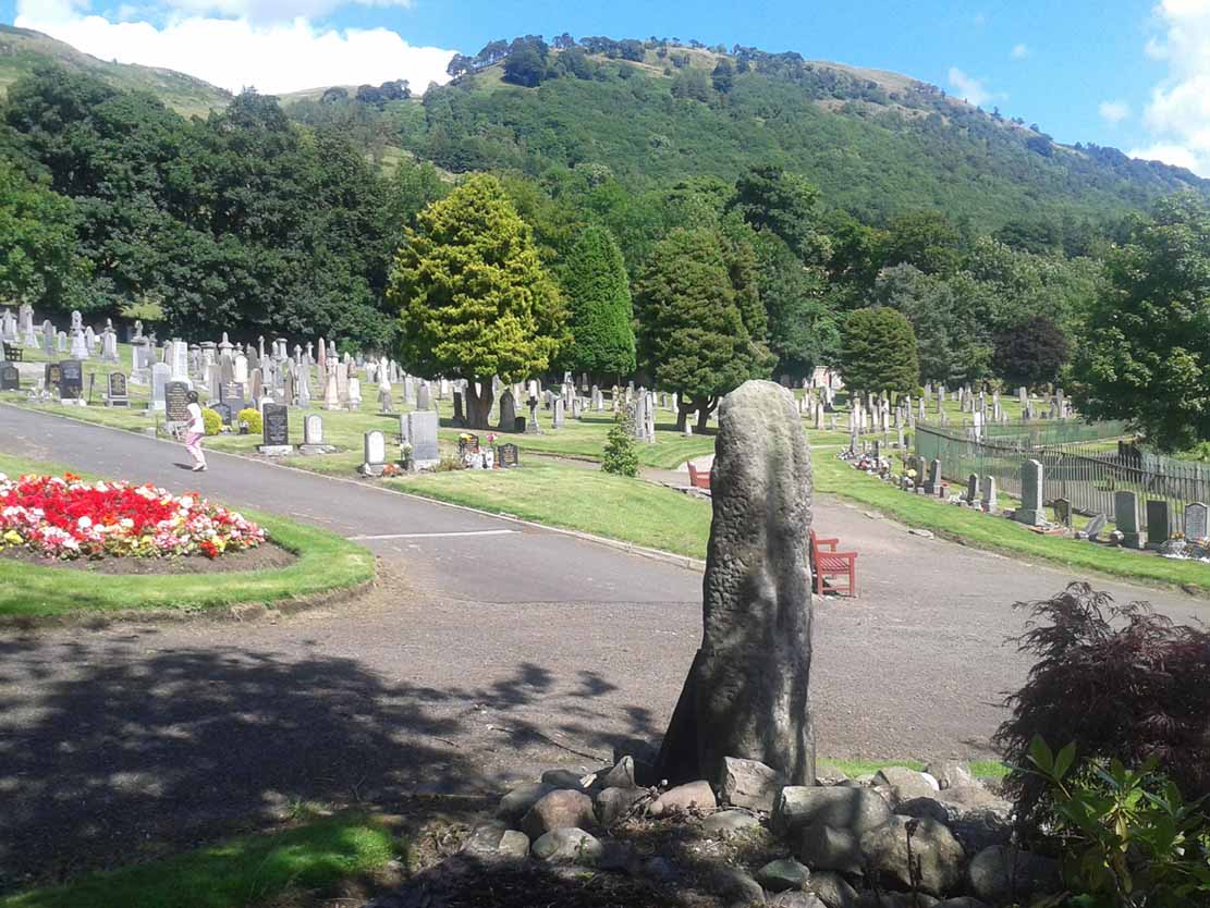
This once important healing stone that was moved a short distance (from grid reference SN 1775 1875 to SN 1770 1874 according to officials) to its present spot, around 1925, whilst having a long history according to the folk traditions of Carmarthenshire, was previously questioned as an authentic site by none other than Prof John Rhys (1875), following his visit to the site in the 1870s.  Although Rhys seemed an isolated voice, some modern archaeologists have also questioned its veracity.  It’s difficult to say precisely what the original nature of the stone may have been, but it was certainly accommodated in medieval times as a healing stone and used in conjunction with a pagan well – which was of course, accommodated by the Church.  If the stone itself had a megalithic pedigree, as some have believed, we know not what it may have been…

As Janet & Colin Bord (2006) wrote, the stone “still survives, but to the casual observer it looks like any other abandoned block of stone,” sitting innocuously within the ring of trees surrounding the church.  An early account of the stone was written by E.L. Barnwell (1872), who told:

“The present church of Llangan in Carmarthenshire is a wretched structure, built in 1820, and is about to be removed, as the population has long since migrated to some distance from it, and in a few years even the memory of Canna’s church having once existed here may cease. There is, however, a relic still left, which we trust will not be overlooked by the local authorities, as indeed it seems to have been hitherto ; for no notice occurs of it in the account of the parish in Lewis’s Topographical Dictionary or any other work. This relic is a rude stone, forming a kind of chair, lying in a field adjoining the churchyard, and about thirty or forty yards from it. When it was removed to its present position is unknown. There was also a well below the church called Ffynnon Canna; and there is still a small brook available, if required, for following the rules prescribed to those who wish to avail themselves of the curative powers of the saint’s chair. It appears that the principal maladies which are thus supposed to be cured are ague and intestinal complaints. The prescribed practice was as follows. The patient first threw some pins into the well, a common practice in many other parts of Wales, where wells are still thought to be invested with certain powers. Then he drank a fixed quantity of the water, and sometimes bathed in the well, for the bath was not always resorted to. The third step was to sit down in the chair for a certain length of time; and if the patient could manage to sleep under these circumstances, the curative effects of the operation were considerably increased. This process was continued for some days, even for a fortnight or longer. A man aged seventy-eight, still living near the spot, remembers the well and hundreds of pins in it, as well as patients undergoing the treatment; but, about thirty or thirty- five years ago, the tenant carried off the soil between the well and the watercourse, so as to make the spring level with the well, which soon after partly disappeared, and from that time the medical reputation of the saint and her chair has gradually faded away, and will, in the course of a generation or two, be altogether forgotten.”

Folklore

In Wirt Sykes (1880) classic text, he told us that the field where the original Canna’s Chair may have been, possessed fairy-lore that we find at other sites, usually ascribed as prehistoric.  He wrote:

“In the middle of this parish there is a field called Parc y Fonwent, or the churchyard field, where, according to local tradition, the church was to have been originally built; but the stones brought to the spot during the day were at night removed by invisible hands to the site of the present church.  Watchers in the dark heard the goblins engaged in this work and pronouncing in clear and correct Welsh these words, “Llangan, dyma’r fan,” which means, “Llangan, here is the spot.””

References:

  1. Allen, J. Romilly, The Monumental History of the Early British Church, SPCK: London 1889.
  2. Baring-Gould, S. & Fisher, John, Lives of the British Saints – volume 2, London 1907.
  3. Barnwell, E.L., “Canna’s Chair,” in Archaeologia Cambrensis, volume 3 (4th Series), 1872.
  4. Bord, Janet & Colin, Cures and Curses: Ritual and Cult at Holy Wells, Heart of Albion: Wymeswold 2006.
  5. Breverton, Terry, The Book of Welsh Saints, Bro Morganwg: Glyndwr 2000.
  6. Davies, Jonathan Ceredig, Folk-lore of West and Mid-Wales, Welsh Gazette: Aberystwyth 1911.
  7. “D.M.”, “Canna’s Chair,” in Archaeologia Cambrensis, volume 4 (4th Series), 1875.
  8. Rhys, John, “On Some of Our Inscribed Stones,” in Archaeologia Cambrensis, volume 4 (4th Series), 1875.
  9. Sikes, Wirt, British Goblins, Sampson Low: London 1880.
  10. Sharkey, John (ed.), Ogham Monuments in Wales, Llanerch: Felinfach 1992.
  11. Westwood, J.O., Lapidarium Walliae: The Early Inscribed and Sculptured Stones of Wales, Oxford University Press 1879.

© Paul Bennett, The Northern Antiquarian 


Fingal’s Stone, Killin, Perthshire

Standing Stone:  OS Grid Reference – NN 5712 3301

Also Known as:

  1. Canmore ID 24192

Getting Here

Fingal’s Stone, Killin

Less than 100 yards up the road from the Co-op in Killin, take the footpath on the same side of the road into the park at the back of the buildings. Keep following the footpath round the back of the buildings and you’ll see the stone in front of you soon enough.

Archaeology & History

Another curious site in this quite beautiful mountainous arena.  Thought to have originally stood by the rounded fairy knoll a bit further up the hill, no one knows for sure when the stone was moved to its present position—but locals will tell you how the curious knob-end atop of the stone was also a later addition to the fallen original, when it was resurrected in the latter half of the 19th century.  C.G. Cash (1912) also found the fairy mound and its companions on the slope above to be of interesting, wondering, as I have, that “they might have been burial mounds.” The local historian William Gillies (1938) said of the stone:

“Both the Old and New Statistical Accounts of the parish of Killin make reference to a site near the village that had been pointed out from time immemorial as the burial place of Fingal, the hero of Celtic folk stories. At this point, which is in the middle of a field immediately behind the schoolhouse, there is a standing stone 2 feet 8 inches high and 5 feet in girth.  The stone had fallen, but in 1889 it was re-erected by Mr Malcolm Fergusson, a patriotic native of Breadalbane.  Without any reference to the original arrangement, a smaller stone was fixed on the top, and others were placed near it. The lands in the vicinity of Fingal’s Stone used to be called Stix.  The name suggests that here, as at Stix between Kenmore and Aberfeldy, there were a number of standing stones, of which this one alone remains.”

And it certainly smells that way… Yet no further monoliths have been found hereby or on the slopes above.

Folklore

Reputed to be a stone that marks the grave of the hero-figure, Fionn.  Local historian  Duncan Fraser (1973) told that:

“Killin is steeped in history and one of its memorials of the past is a standing stone in a field behind the school, that is said to mark the spot where the mighty Fionn lies buried.  He is believed to have died about the end of the Iron Age, in 283 AD.”

Gazing N, to the Cailleach

William Gillies (1938) also reported how tradition said that an early church and graveyard was once to be found at the original site of Fingal’s Stone. Legends of Finn, his magick and his encounters with both faerie and men are found all over the landscape in this neck o’ the woods….

References:

  1. Cash, C.G., “Archaeological Gleanings from Killin,” in Proceedings of the Society of Antiquaries of Scotland, volume 46, 1911-12.
  2. Fraser, Duncan, Highland Perthshire, Standard Press: Montrose 1973.
  3. Gillies, William A., In Famed Breadalbane, Munro Press: Perth 1938.
  4. Wheater, Hilary, Killin to Glencoe, Appin Publications: Aberfeldy 1982.

© Paul Bennett, The Northern Antiquarian


Clach na Boile, Kinloch Rannoch, Perthshire

Standing Stone:  OS Grid Reference – NN 66983 57984

Also Known as:

  1. Canmore ID 24556
  2. Clach na Voile
  3. Stone of Fury

Getting Here

Clach na Boile & its rocky landscape

From the lovely village of Kinloch Rannoch, take the south road over the river that heads (eventually) to Aberfeldy.  3-400 yards along, another small road meets with the one you’re on, on your right. Stop here! Then look across at the field ahead of you, on your left, and you’ll see a small standing stone amidst the green.  That’s it!

Archaeology & History

This is a small, squat but impressive standing stone, less than 4 feet tall, set amidst a beautiful landscape which catches the eye in every direction.  Found close to the remains of several prehistoric cairns, it seems probable that funerary associations would have happened here, although direct evidence is lacking.

Folklore

Clach na Boile, looking south

Although I can find nothing specific to account for the Gaelic meaning (“stone of fury”) of the monolith, on the other side of the road in the trees is the old house of Innerhadden, where a curious ghost story told how an old inhabitant there was helped by the spirit of one who died in the Battle of Culloden. (Cunningham 1989)

References:

  1. Cunningham, A.D., Tales of Rannoch, Perth & Kinross District Library 1989.

© Paul Bennett, The Northern Antiquarian 


Allt Leathan Stone, Fortingall, Perthshire

Standing Stone: OS Grid Reference –NN 7251 5659 

Getting Here

Allt Leathan stone

Follow the same directions to reach the Allt Leathan enclosure and hut circles.  Walk along the eastern side of the hill on which the enclosure mainly sits, and as it slopes down the hill, you’ll note an odd-shaped stone leaning at an angle less than halfway down.

Archaeology & History

A truly curious and fascinating site, not previously recorded, but found by Paul Hornby on August 7, 2012, during a venture to explore the nearby settlement and hut circles around Meall Dubh.  On the eastern slope over the edge of the Allt Leathan enclosure, with its hut circles and possible cairns, we see this upright worn stone, leaning at an angle, which would stand nearly 5 feet high if pushed properly upright.  It is found in association with two other smaller stones, all of which stand and lean in the same direction.

Possible cairn remnants surrounds base of stone
…and again

Around the base of the main stone is a scatter of small rocks, as if suggesting that a cairn was once next to the standing stone, perhaps inferring that the stone marked a tomb.  There is also a very distinct line of walling running along the axis of the upright stones, meaning that we cannot discount the possibility that the monoliths here were connected with a walled enclosure in some capacity. And considering the excess of other prehistoric remains close by, this may be more likely than not!

© Paul Bennett, The Northern Antiquarian


Tullibody Stone Circle, Clackmannanshire

‘Stone Circle’ (destroyed):  OS Grid Reference – NS 86 95

Archaeology & History

In Alex Wilson’s (1901) rare work he gives the only reference of what may have been a stone circle once found in the township of Tullibody.  On a talk given at the Alloa Archaeology Society in the 19th century, the site was mentioned by one of the speakers in his talk on the standing stones of Stirlingshire and district.  Mr Wilson told us:

“…at a meeting in November 1871, Rev. Mr Bryson made one of his first speeches before the Society, and spoke of Boulders found in the district, and how these were gradually disappearing owing to the utilitarian spirit of the age.  Mr Bryson related how that he had been informed that about 60 or 70 years ago there existed seven or eight boulders round about the Boulder at Tullibody, which Mr Duncan had spoken of.”

This is a brief but intriguing account!  Whether we can ascribe the “seven or eight boulders” in the description as merely glacial erratics, or whether the ruins of a stone circle were here as the description seems to imply, we don’t know.  If anyone has any additional information they can add to this account, please let us know.

References:

  1. Wilson, Alex, Review of Proceedings since Inauguaration, Alloa Society of Natural Science and Archaeology, Buchan Bros: Alloa 1901.

© Paul Bennett, The Northern Antiquarian


Whooping Cough Stone, Struan, Perthshire

Legendary Rock: OS Grid Reference – NN 816 653

Getting Here

Old photo of the stone (after Duncan Fraser)

Up the A9 past Blair Atholl, a few miles later there’s the turning for Struan.  Scarcely a mile east of old Struan Church, head past the old farmhouse of Old Kindrochat and keep going eastwards along the edge of the trees for about 200 yards until you reach the sheepfold. There you’ll see a singular rock sitting alone by the fence. That’s it!

Archaeology & History

This little known healing stone was, at one time last century, of great repute in the Highlands. Today, very few people even know it exists. One of many rocks that were said to possess healing abilities, this one (obviously) was of great repute in the curing of whooping cough. But it wasn’t the rock alone that did the work here, for upon its edge was a small basin into which rainwater collected and this, when used correctly and in due accord with ancient ritual tradition, could enact the cure.  Mr Duncan Fraser said of this fascinating healing stone:

“The grey water-worn stone is about 4ft 6in long, 2ft 6in broad and 2ft high, with a deep gash on top, where the water lingers even in long dry spells. When full it holds about half-a-gallon. People were still coming here with their sick children as late as 1860 — and bringing a spoon made from the horn of a living cow. There was no cure without that.”

The ritual “spoon made from the horn of a living cow” was an important ingredient at another site with the reputation for curing whooping cough about 50 miles south of here, near Balquhidder. (see Whooping Cough Well, Killin)  What truly fascinates me is the origin of this stone and its medicinal virtues.  When  did the healing rites first start here – how long ago…?

References:

  1. Fraser, Duncan, Highland Perthshire, Standard Press: Montrose 1969.

© Paul Bennett, The Northern Antiquarian


Balbirnie Stone Circle, Markinch, Fife

Stone Circle: OS Grid Reference – NO 28585 02968

Also Known as:

  1. Balfarg Stone Circle
  2. Druid’s Circle

Getting Here

Balbirnie stone circle – with Marion checking it out!

Take the A92 road running north out of Glenrothes towards Freuchie and, after a couple of miles out of town, you’ll hit the B969 road on your left.  Across from here on the other side of the road, you’ve just passed a small B-road that takes you to Markinch.  That’s where you need to be!  Go along there for less than 100 yards and turn first right, swerving along the tree-lined road for 200 yards or so. Watch out, just before the first house on your left, for a footpath which leads into the woods. Walk down it, barely 10 yards!

Archaeology & History

This is a lovely megalithic ring in a lovely setting – albeit a new one. The circle was originally positioned some 125 yards northwest of here and would have been destroyed, but was thankfully reconstructed by Fife Council before road-widening of the A92 was done. And the job’s a good one! But as Burl (2005) tells, this wasn’t the first time Balbirnie had been threatened with damage:

The southeast stones & cists
Balbirnie from the roadside, looking SE

“With some stones removed in the eighteenth century, dug into in 1883 when bones and sherds were found, damaged by trees, it was finally excavated and restored in 1970-71,” before the main road was built. Thankfully it’s still here – and an excellent stone circle it is! However, the reconstructed site here doesn’t show the circle in its entirety. Originally there were ten standing stones making up the ring, as opposed to the seven you can see today.

The site was built amidst the scatter of other larger, and once more impressive, mythically important monuments than the circle – but it’s as likely that the circle added more to the sacred dimensions of the region as a whole when it first came to be built. For on the other side of the A92 we can still see the denuded remains of the Balfarg Riding School Henge, with imitations of its internal upright posts resurrected into position to give an idea of what once stood inside the sacred enclosure. And then about 200 yards west of that, the gigantic Balfarg Henge is impressively surrounded by a modern housing estate, built with the henge in mind, with its outlying megaliths and internal level surface area graciously intact. It’s a truly impressive prehistoric area all round, although the Balbirnie stone circle was built some considerable time after the two henges had been done, many centuries later…

Before the circle was moved, the consensus profile of the site was that given by the Royal Commission (1933) lads following their visit here in June 1925, when they told it looked like this:

Royal Commission ground-plan, c.1933

“At the southern end of a small wood on the east side of the main road from Kirkcaldy to Falkland, about 180 yards south of Balbirnie Lodge, are the remains of a large circular cairn and of the setting of standing stones by which it was once surrounded… The circle, which has had a diameter of some 48 feet, has been composed of sandstone boulders. Four of these are still in place, but one other on the southeast has been slightly displaced, while against the stone on the northeast lie two large boulders, which apparently have been transferred to this position. Any other stones that may once have existed have been removed or destroyed. The greatest height above ground of any of those that survive is 5 feet 6 inches, while one, which rises no more than 2 feet, measures in circumference as much as 9 feet 9 inches at the base. The cairn itself seems to have been broken into at two points. No record of these excavations appears to be extant, but a number of fragments of cinerary urns from the site are preserved in the National Museum. These indicate that, as might have been inferred from its general character, the monument was sepulchral and dates from the Bronze Age.”

Sepulchral indeed. When the stone circle was excavated at the beginning of the 1970s by J.N.G. Ritchie (1974) and his mates, it was discovered this was a primary function of the site. As Burl (2000) wrote:

“At Balbirnie patches of cremated bone lay underneath some circle-stones. Whatever the ceremonies here they were interrupted when the site was converted into a cemetery. Four or five cists associated with a late beaker and a jet button were constructed within the ring. The date of about 1650 BC came from wood alongside the beaker. Stretches of low walling were put up between the stones forming a continuous barrier…analogous to the embanked stone circles elsewhere in Britain that seem generally to belong to a period in the mid-second millennium… But the first cists did not long remain undisturbed and were seemingly rifled when later cists were built that contained the cremations of women and children… One of these later cists held a food-vessel and a flint knife.

“The stone circle was further abused. A low cairn was piled over all the cists. Sherds of deliberately broken urns, one with barley impressions, were scattered amongst the boulders, intermingled with small coagulations of burnt human bone. This last phase at Balbirnie occurred late in the second millennium BC, for a C-14 determination of…1200 to 900 BC came from the land surface that had built up within the ring during the centuries while the stone circle remained open to the weather.”

Measuring 49 feet across at the widest, this flattened ellipse also possessed a curious rectangular section of laid stone, near the middle of this circle, almost ‘Roman-road’ like in appearance and covering about a quarter of the internal arena. It’s visible today at the reconstructed site and looks almost intrusive! Measuring some 11 feet by 9 feet, the flat stone surface has been suggested as a place where corpses were rested.

Also found within two of the tombs inside the circle were the cup-and-ring marked stones of Balbirnie 1 and Balbirnie 2, showing yet again the relationship that some of these carvings have with spirits of the dead.

References:

  1. Burl, Aubrey, “Intimations of Numeracy in the Neolithic and Bronze Age Societies of the British Isles (c.3200-1200 BC),” in Archaeological Journal, volume 133, 1976.
  2. Burl, Aubrey, Rings of Stone, BCA: London 1979.
  3. Burl, Aubrey, The Stone Circles of Britain, Ireland and Brittany, Yale University Press 2000.
  4. Burl, Aubrey, A Guide to the Stone Circles of Britain, Ireland and Brittany, Yale University Press 2005.
  5. Denston, C.B., “The Cremated Remains from Balbirnie, Fife,” in Archaeological Journal, volume 131, 1974.
  6. Ritchie, J.N.G., “Excavation of the Stone Circle and Cairn at Balbirnie, Fife,” in Archaeological Journal, volume 131, 1974.
  7. Royal Commission on the Ancient & Historical Monuments, Scotland, Inventory of Monuments and Constructions in the Counties of Fife, Kinross and Clackmannan, HMSO: Edinburgh 1933.

AcknowledgementsHuge thanks to Marion Woolley for getting us out to see this and the related neolithic monuments.  Cheers m’ dears!

© Paul Bennett, The Northern Antiquarian


Boat Stone, Blackford, Perthshire

Standing Stone (fallen): OS Grid Reference – NN 87202 07286

Getting Here

Fallen monolith in the grass

From Blackford on the north side of the A9, cross over and take the small B-road which quietly runs up and over Sheriffmuir towards Dunblane.  After a mile, keep your eyes keen for the approaching woodland on your right-hand side; for in the field just before the woods, you’ll see a patch of grass near the corner of the field with a long stone poking out of it. That’s it!

Archaeology & History

It seems that very little has been written about this monolith in any of the archaeology texts, but it’s ascribed locally to be a fallen standing stone.  The site’s described in Finlayson’s (2010) fine local megalith guide where he points out how it’s in line with other nearby standing stones at Gleneagles and the White Stone – and the line is damn close!

…and from another angle…

With a quartz vein running through it, the stone lays some thirteen feet long and was, at some time in the not-too-distant past, readied to be quarried, as evidenced by the chisel-marks cut into it, prior to the usual destruction. But this time, for some reason, someone must have come to the rescue and prevented its demise…thankfully…

The farmer annually cuts around the fallen stone, shaped like a long boat (hence the name), near the top corner of the field. It would have looked damn good when stood upright, standing about ten feet in height and visible for a good distance. But today it’s quite forlorn laid here, seemingly alone, in this quiet part of the country, and is probably only one of interest to hardcore megalithomaniacs amongst you!

References:

  1. Finlayson, Andrew, The Stones of Strathearn, One Tree Island: Comrie 2010.

© Paul Bennett, The Northern Antiquarian


Alva Church, Alva, Clackmannanshire

Standing Stones:  OS Grid Reference – NS 88812 97235

Getting Here

Alva’s standing stone

Go on the A91 through Alva, eastwards, and just before you go out of the town, note the small road on your left up to the graveyard.  As you go into the graveyard, keep your eyes peeled on your left-hand side.  You can’t really miss it!

Archaeology & History

Reported as “lost” or “destroyed” in many official reports, one of at least two standing stones that were reported in the Old Statistical Account of 1795 can still be found at the bottom of the graveyard, adjacent to the old holy well of St. Serf, at the edge of Alva town  Very little has been written about it, and when it was mentioned in the OSA, the stones were only added in a foot note to the impressive stone cross on the outskirts of Alloa, saying:

“There are two stones resembling this one, in the neighbouring parish of Alva, at no great distance from the church, but not close to one another. They are both near the foot of the Ochils.”

A little person by its side
From the stone, looking NE

When some of the lads from the Scottish Royal Commission came here in July 1927, they could find no remains of any such standing stones and simply reported that they “no longer exist.” However, as visitors can plainly see, a tall upright standing stone still remains here, albeit repositioned by the good local people of Alva several decades ago.  Standing more than seven-feet tall, the stone is very weather-worn on one side, with a plaque at the bottom.

References:

  1. Royal Commission on the Ancient & Historical Monuments, Scotland, Inventory of Monuments and Constructions in the Counties of Fife, Kinross and Clackmannan, HMSO: Edinburgh 1933.

© Paul Bennett, The Northern Antiquarian 

Hawk Hill Cross, Alloa, Clackmannanshire

Cross: OS Grid Reference – NS 90135 92660

Also Known as:

  1. Parkmill
  2. Pillar Stone of Brath

Getting Here

Hawk Hill Cross, Alloa

From Alloa head east along the A907 road and park up at Morrison’s supermarket a half-mile on. From here, keep walking along the same road, but make sure you go on the dirt-track running parallel with the main road, and which runs alongside the field in which this monument is clearly visible. Just make sure you only visit it when the crops aren’t growing (between September through to April is OK).

Archaeology & History
This is a highly impressive monument, but I for one doubt that it has a wholly christian origin… The fact that a stone circle was on the same ridge totally visible a couple of hundred yards away, and a cluster of Bronze Age cairns immediately west, adds to my doubt; along with the sheer size of this thing trying to grab attention to itself. You’ll have to visit it yourself and see what I mean.

The stone was first described in the Old Statistical Account of the area in 1795, and it told:

“About a mile east of the town, there is a large upright stone, 7 feet 4 inches above the surface of the ground. It is three feet broad, and thought to be very deep in the Earth. The old people used to speak of the figure of a man on horseback, which they had seen on it. If any thing of that kind, or letters (as it is said), have been formerly observed, they are now totally effaced.”

However, in a footnote to this entry, it was said that,

“when the adjacent farm was enclosing, upwards of 20 years ago, a ditch was made close to the stone, when many human bones were discovered; which proves that a battle or skirmish had some time or other taken place near that spot; and probably some man of eminence was buried hard by, as it was a common practice of the Picts on such occasions. There are two stones resembling this one, in the neighbouring parish of Alva, at no great distance from the church, but not close to one another. They are both near the foot of the Ochils.”

It seems most probable that this great cross-carved monolith had some relationship to our heathen mythic history—an idea which has been put forward by others historians in bygone times. In Daniel Wilson’s (1851) huge work, he told us:

“On ground about half a mile to the east of the town of Alloa, called the Hawkhill, is the large upright block of sandstone sculptured with a cross which is represented in the annexed engraving. It measures ten and a quarter feet in height, though little more than seven feet are now visible above ground. A similar cross is cut on both sides of the stone, as is not uncommon with such simple memorials. During the progress of agricultural operations in the immediate vicinity of this ancient cross, in the spring of 1829, Mr. Robert Bald, C.E., an intelligent Scottish antiquary, obtained permission from the Earl of Mar to make some excavations around when, at about nine feet north from the monumental stone, a rude cist was found, constructed of unhewn sandstone, measuring only three feet in length, and at each end of the cover, on the under side, a simple cross was cut. The lines which formed the crosses were not rudely executed, but straight and uniform, and evidently finished with care, though the slab itself was unusually rude and amorphous. The cist lay east and west and contained nothing but human bones greatly decayed. Drawings of the cross and a plan of the ground, executed by Mr. Bald, are in the possession of the Society of Antiquaries. Here we possess a singularly interesting example of the union of Christian and Pagan sepulchral rites: the cist laid east and west, according to the early christian custom, yet constructed of the old circumscribed dimensions, and of the rude but durable materials in use for ages before the had superseded the aboriginal Pagan creeds.”

Old drawing of the site (after Wilson 1851)
Hawk Hill Cross, looking north

A few years later there was another account of this cross published in the Proceedings of the Society of Antiquaries, Scotland (1889), echoing much of what Wilson described, telling of the discoveries of many human remains found hereby. And when the Royal Commission (1933) account of the place was written after their inspection team visited the site in 1925, they told:

“This slab…is set up on a knoll about 200 yards south of the main roadway between Alloa and Clackmannan and about midway between the site of the (Hawk Hill) cairn…and that of the (Hawk Hill) stone circle… It is packed round the base with fairly large stones and stands with its broad faces east and west. A cross of Celtic form is incised on both sides, the incisions being about half an inch in depth. On the east face the shaft is made to spring directly from a base, without the intervention of a basic line. The design on the west face is similar, but the shaft here has been almost entirely obliterated by weathering. The slab is 8 feet in height, 2 feet 7½ inches in width at the base, and 9 inches in thickness.”

Notice that the more recent accounts don’t mention the horse carving: an intriguing element which was however mentioned in some early local history works of the place.  Indeed, some postulate that this may have Pictish origins. They may be right. As local historian T.C. Gordon (1937), told,

“that the old people of the parish could remember seeing on the soft surface of the stone the figure of a man on horseback.”

Cross on the east face
Cross on the west face

On the day I visited this stone I couldn’t make out any carved horse, but it seemed that something may once have been carved near the bottom the western face…perhaps… One writer also suggested that the nearby place-name of Gaberston may have related to this stone cross, with the word literally meaning ‘The Pillar Stone of Brath (Brude),’ which as Mr Gordon said, thus provides “the link between the stone and (the Pictish leader) Brude, and this link is strengthened when we remember that the burn that runs through Alloa is called ‘the Brathy Burn.’”

The possible Pictish motifs of a horseman were mentioned again in a letter from the local County Planning Officer to the Alloa County Clerk in 1971, along with a recommendation that the cross be removed and placed into a museum to prevent further weathering and erosion. Thankfully this suggestion was not followed through and the cross remains where it belongs: in its position in the landscape to beguile and intrigue us over its hidden commemorative past. Long may it remain upon its hill.

A very impressive site indeed…

Folklore

Thought locally to have played a part on an alignment or ley line with a little-known Druid Stone by the roadside in Alloa, the Hawk Hill cairn, and Hawk Hill stone circle to its east. The historian T.C. Gordon (1937) told that the cross marked the site where the Picts fought against the Saxons, saying:

“We know that Finguine, son of Deleroith, died in that battle in 711 AD, and maybe Brude too. A stone cross still marks the place at Hawkhill.”

References:

  1. Gordon, T. Crouther, A Short History of Alloa, Alloa Advertiser 1937.
  2. Lothian, James, Alloa and its Environs, Alloa Advertiser 1861.
  3. Miller, Peter, “Notices of the Standing Stones of Alloa and Clackmanan,” in Proceedings of the Society of Antiquaries, Scotland, volume 23, 1889.
  4. Royal Commission on the Ancient & Historical Monuments, Scotland, Inventory of Monuments and Constructions in the Counties of Fife, Kinross and Clackmannan, HMSO: Edinburgh 1933.
  5. Wilson, Daniel, The Archaeology and Prehistoric Annals of Scotland, Sutherland & Knox: Edinburgh 1861.

© Paul Bennett, The Northern Antiquarian