Take the Oakworth Road outta Keighley, turning right after a quarter-mile up Fell Lane. Go all the way up the very end (a mile or so), turning right at the end. After 100 yards or so, go up the track to the True Well Hall equestrian centre. As you approach the farmhouse, look on the grassy slope to the left and you’ll see a small run-down stone structure in the field above you. That’s it!
Archaeology & History
This is a curious site by virtue of so little being said of it, despite some modern proclamations of it having pagan values. Even the local historians say little on the place, with William Keighley (1858) being our notable exception. In his notes on the erroneous dedication of the Jennet’s Well to a fictitious saint of the same name, he mentions this once important water supply, writing:
“Westwards of Jennet’s Well there was another fountain, emphatically styled the ‘true well’, and probably from its once boasted efficacy intended as a rival to the former. This spring though no longer remembered for its healing qualities, evidently gave name to the farmhouse denominated ‘True Well Hole.'”
In Wright’s Dialect Dictionary (1898) we find the word ‘trew’ — also written as ‘true’ or ‘trow’ — could mean “to trust, believe, feel sure”, which may be applicable in terms of the value of the waters that once flowed here. We may never know. Though note should be made of the error at a recent exhibition in Cliffe Castle museum, where the 1842 Tithe Awards map of the region was copied and the field-names listed, showing the old True Well erroneously displayed as the ‘Time Well’. I assume they must have had a long day when they were copying the notes…!
Spring behind True Well Hall
A little further along the track running beyond True Well Farm we find another spring of water emerging from the grassy hill and which, perhaps, relates to the True Well. On the 1852 OS-map, we see a ‘trough’ shown in front of the farmhouse and not in the position where the modern map shows the True Well to be — and where the recent stone-worked trough in the photo is shown. In fact, on the 1852 map, no such well nor stonework is shown in the position presently deemed to be where the True Well is supposed to be, so the original position of the well is unclear. Is it possible that the spring of water which runs from the hillside behind True Well Farm may have been the site which gave this spot its name. Certainly the water from this spring is quite fresh and drinkable. If anyone knows owt more about the history of this curious site, it would be good to hear from you.
References:
Keighley, William, Keighley Past and Present, Arthur Hall: London 1858.
This little known site, long since destroyed during the construction of Keighley Railway Station, was found in a curious spot, close to the bottom of the Aire Valley. Most (known) prehistoric burials occur on the higher grounds in this area. And though we don’t appear to have the exact location of the find, it was pretty close to either side of Keighley’s old railway station (which is shown as 100 yards to the other side of the road of the present station on the 1852 OS map). This may position the site as being on the grounds opposite and below St. Anne’s Church; otherwise it was getting closer to where the River Worth runs by. In Keighley & Holmes’ early (1858) work they told that,
“Whilst excavating for the Railway within about a hundred yards of the Keighley station, one of the labourers discovered three urns containing a quantity of human bones. Two of them were unluckily broken, one being large enough to hold eight or nine quarts. The one brought away whole, and seen by the present writer, may hold about a quart; it is somewhat distastefully designed, moulded by hand out of the common clay, without glaze, and rudely ornamented on the outside by some sharp implement. The once animated contents of each urn were covered by a square flat stone.”
This final remark seems to indicate the urns were located in a cist (a small stone grave), but we don’t know whether this was found within the remains of a denuded tumulus or stone cairn. However, considering the lack of any remarks about a large pile of stones (which would have been very noticeable) covering this burial site, it would seem more probable that this site was originally an earth-covered tumulus, whose visibility and knowledge had long since diminished in this part of Airedale.
References:
Keighley, William & Homes, Robert, Keighley, Past and Present, R. Aked: Keighley 1858.
Go northwest along the country lane running between High Utley (on the outskirts of Keighley) and Steeton known as Hollins Lane, which then becomes Hollins Bank Lane. You’ll see the fine castle building as you go along, known simply as The Tower arising from the top of the tree-line. As you get to the driveway leading down to the Tower, a less impressive farm building is on the other side of the road, known as Hollins Bank Farm. On the right-hand side of this house is an old overgrown road. Walk along here to the end, going into the field immediately left where a small group of stones can be seen halfway up the field by the tree. You’re here!
Archaeology & History
First discovered one sunny afternoon on April 7, 2010, in the company of Buddhist scholar Steve Hart, this is a really curious carving, inasmuch as it seems to have been deliberately carved around what may be curious naturally eroded cup-forms. You’ll have to visit it to see what I mean. They’re a bit odd. Almost too perfect as cups to be the ancient eroded ones we’re used to looking at. But this aside….
…and againDragon Stone, looking NW
It’s a lovely flat stone, with curvaceous lines running across the middle and edges and into cup-markings. Although some of the cups give an impression of being natural, others have the authentic-looking ring to them, with at least one of them possessing a near-complete ring encircling it (as you can faintly see in the close-up photo here). There are at least 19 cup-markings on this stone, and four main ‘lines’ running roughly in north-south directions, with the cups interspersed between them. At the top (north) end of the rock, separated by a crack, the lines stop and we just have some cup-markings. The crack in the stone may have been functional here.
Although graphically different, the carving has a similar feel in design (for me at least) to that of the Wondjina Stone at Rivock Edge, on the other side of the Aire Valley a couple of miles east of here — though this newly found carving is in a better state of preservation. The small scatter of rocks around it seem to have been unearthed or moved recently by the land-owner (who aint keen on you looking on his land, so be careful) and the good state of preservation may be that they were only unearthed sometime this century. We must also keep in consideration that the lines that run across the surface of this stone are water-lines and may be more the result of Nature’s hand than humans. It’s obvious that some human intervention has occurred here, but it may be difficult to ascertain the precise degree of affectation between the two agencies.
Close-up of cups & lines
According to the archaeological record-books there are no carvings here, but another simple cup-marked stone accompanies this more extravagant serpentine design just a few yards away; a simple cup-marked stone may be seen at the top of the hill; and the faint Currer Woods carving can be found 0.68 miles (1.09km) due west of here, on the other side of the small valley. Other outcrop stones scatter the fields and slopes here, some of which still need checking to see whether or not further carvings exist.
…And for those who may bemoan my seemingly romantic title of the carving: remember! — close by in Steeton township, between the years 1562 and 1797, there was an old field-name known well to local folk, of “one parcel of arable land in town field called Drakesyke, 3 acres”, i.e., the dragon’s stream or dyke. (Gelling 1988; Smith 1956)
References:
Clough, John, History of Steeton, S. Billows: Keighley 1886.
Gelling, Margaret, Signposts to the Past, Phillimore: Chichester 1988.
Smith, A.H., English Place-Names Elements – 2 volumes, Cambridge University Press 1956.
Go through the village of Stanbury, past the last of the two reservoirs until you’re on the western edge of Ponden. Stop and look up the slopes to your south. This spot was recently found and photographed by Richard Stroud: a curious-looking mound with all the hallmarks of being a forgotten tumulus. We’ve gotta check it out properly though!
Folklore
Although not in the archaeological records (not too unusual in Yorkshire it seems), the site does have some literary references and some all-too-common folklore motifs. Perusing my library for info about another nearby site (the Cuckoo Stones), I found the following said of this place in a rare book by James Whalley called The Wild Moor (1869, pp.103):
“It appears that some hills, as well as dales…have silvery names. There is a hill which is on the right hand on the way from Ponden House to Crow Hill Moor, which is distinguished by the beautiful designation of ‘Silver Hill.’ The hill is surrounded by a wall (I suppose to guard the treasure) and its surface is adorned with trees. Grey-headed men living on the borders of Crow Hill and Lancashire Moors affirm that during the Scotch rebellion here was deposited a large chest of silver, which was hid in the hill. It would appear as if the chest of silver is still there!”
This tradition was echoed a decade later by J. Horsfall Turner, and then again by Halliwell Sutcliffe in 1899, who reckoned the “vast treasure was said to have been buried during the ’45 rebellion,” adding how “the fields which climb this hill were well tilled aforetime through being constantly turned over in search of the treasure” – but nowt was ever found.
An additional bit of folklore tells of two spirits nearby: one of a man; another of a fiery barrel — either a remnant of earlier solar folk traditions hereby, or perhaps just an earthlight. One of these (the fiery barrel) rolled down the hill nearby; whereby the ghost of the man walked by the hillock along the track from Ponden House a little further east.
References:
Horsfall-Turner, J., Haworth Past and Present, J.S. Jowett: Brighouse 1879.
Sutcliffe, Halliwell, By Moor and Fell in West Yorkshire, T. Fisher Unwin: London 1899.
Get up to the Twin Towers right at the top of Ilkley Moor (Whetstone Gate), then walk east along the footpath, past the towers for about another 100 yards, looking out on the other side of the wall until it meets with some other walling running downhill onto Morton Moor. Follow this walling into the heather for a few hundred yards. Where it starts dropping down the slope towards the small valley, stop! From here, follow the ridge of moorland along to your left (east) and keep going till you’re looking down into the little valley proper. Along the top of this ridge if you keep your eyes peeled, you’ll find the stone cross base sitting alone, quietly…
Archaeology & History
This old relic, way off any path in the middle of the moor, has little said of it. Whilst its base is still visible — standing on a geological prominence and fault line — and appears to taken the position of an older standing stone, christianised centuries ago, the site is but a shadow of its former self. When standing upright may centuries back, the “cross” was visible from many directions. We discovered this for ourselves about 20 years back, when Graeme Chappell and I sought for and located this all-but-forgotten monument. When we found the stone base, what seemed like the old stone cross lay by its side, so we repositioned it back into position on July 15, 1991. However, in the intervening years some vandal has been up there and knocked it out of position, seemingly pushing it downhill somewhere. When we visited the remains of the cross-base yesterday (i.e., Dave, Michala Potts and I) this could no longer be located. A few feet in front of the base however, was another piece of worked masonry which, it would seem, may have once been part of the same monument.
Cross-base, looking northClose-up of cross-base
Years ago, after Graeme and I had resurrected the “cross” onto its base, I went to visit the Bradup stone circle a few weeks later and found, to my surprise, the upright stone in position right on the skyline a mile to the northeast, standing out like a sore thumb! This obviously explained its curious position, seemingly in the middle of nowhere upon a little hill. This old cross, it would seem, was stuck here to replace the siting of what seems like a chunky 3½-foot long standing stone, lying prostrate in the heather about 10 yards west of the cross base.
Stuart Feather (1960) seems to be the only fella I can find who described this lost relic, thinking it may have had some relationship with a lost road that passed in the valley below here, as evidenced by the old milestone which Gyrus and I resurrected more than 10 years back. Thankfully (amazingly!) it still stands in situ!
If you aint really into old stone crosses, I’d still recommended having a wander over to this spot, if only for the excellent views and quietude; and…if you’re the wandering type, there are some other, previously undiscovered monuments not too far away, awaiting description…
References:
Bennett, Paul, The Old Stones of Elmet, Capall Bann: Chieveley 2001.
Feather, Stewart, “A Cross Base on Rombald’s Moor,” in Bradford Antiquary, May 1960.
Feather, Stewart, “Crosses near Keighley,” in Cartwright Hall Archaeology Group Bulletin 5:6, 1960.
From Steeton go to the top of Mill Lane, turning left up High Street. After about 200 yards, turn right (opposite Falcon Cliff street) and go down past the end of the row of terrace houses, to the end of the dirt-track past the allotments. Then cut up the fields to the rocky crags a coupla hundred yards above you on the left. Over the wall at the top, look out for the single tree in the field by the walling where there’s a small cluster of stones. That’s it!
Archaeology & History
The little Crater Stone and its more ornate companion, below
Hiding away on private land, this lovely simple carving was first located on Wednesday, April 7, 2010 (in the fine company of the Great Guru). Our initial assessment found it to be just a simple cup-marked stone with 4 normal cup-marks, plus two large ‘bowls’ just where the rock goes into the ground. When we found it the other day, Steve pulled a little bit of the earth back to get a better look at the stone, but we need to return here to unearth the rest of the stone (we didn’t have utensils with us this day, as we were just playing out).
The position of the stone in the land is excellent for views, looking down on the greater-looking Dragon Stone carving just a few yards away, but also looks across the Aire Valley and onto the moorland heights above Rivock, and the south-side of Ilkley Moor. I’ll update and add further notes and clearer images when we go back to the site (hopefully) in the next week (aswell as hopefully conjure up a more respectable title!).
Follow the same directions to reach the Harden Moor circle. From here, walk down the footpath at its side down the slope for 100 yards and take the first little footpath on your left for 25 yards, then left again for 25 yards, watching for a small footpath on your right. Walk on here for another 100 yards or so, keeping your eyes peeled for the image in the photo just off-path on your left, almost overgrown with heather.
Archaeology & History
This is just one of several cairns in and around this area (I’ll probably add more and give ’em their own titles and profiles as time goes by), but it’s in a pretty good state of preservation. Nothing specific has previously been written about it, though it seems to have been recorded and given the National Monument number of 31489, with the comment “Cairn 330m north of Woodhead, Harden Moor.” (anyone able to confirm or correct this for me?)
It’s a good, seemingly undisturbed tomb, very overgrown on its north and eastern sides. Three pretty large upright stones, a couple of feet high, remain in position with an infill of smaller stones and overgrowth (apart from removing a little vegetation from the edges to see it clearer, we didn’t try disturbing it when we found it). It gives the impression of being a tomb for just one, perhaps two people and is more structured than the simple pile-of-stone cairns on the moors north of here above Ilkley and Bingley. Indeed, the upright stones initially gave the impression of it once being a small cromlech of sorts! Other cairns exist close by, but until we get heather-burning done up here, they’re difficult to find – or at least get any decent images of them!
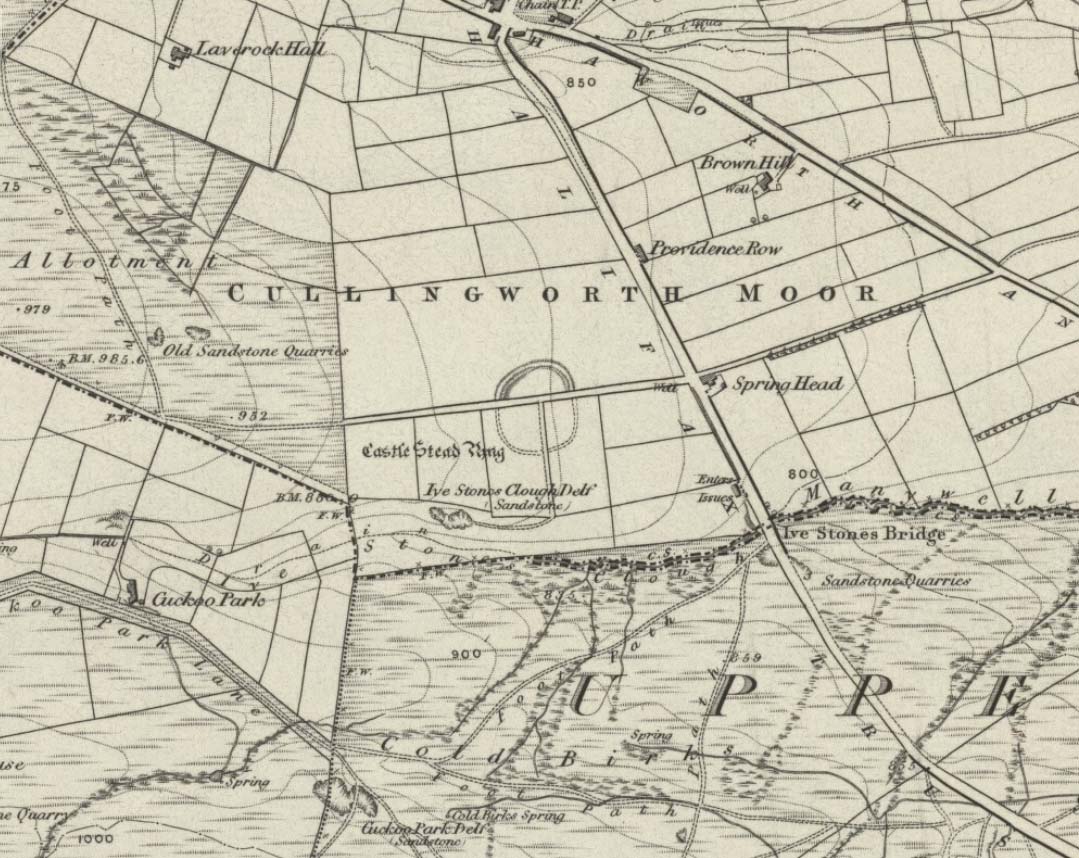
Dead easy this one! On the Keighley-Halifax A629 road, about 500 yards south past Flappit Spring (public house), there’s a small road to your right. Walk on here for 200 yards and look in the field to your right. If the grass is long you might struggle to see it, but gerrin the field and it runs right up against the wall. Y’ can’t miss it really! You can park up a coupla hundred yards down the A629 main road, by the old quarry, and walk back to get here.
Archaeology & History
Although I’ve earlier described this as “nowt much to look at,” the more I come here, the more I like the place (sad aren’t !!?). The hard-core archaeology folks amidst you should like it aswell. Not to be confused with the site of the same name a mile to the south of here, this large earthwork was shown on the 1852 OS-map as a complete ring, which is also confirmed in old folklore; and a survey done by Bradford University in the late 1970s indicated a complete circle was once in evidence. To view this for yourself: if you type the OS grid-reference into Google maps, you’ll see from the aerial image that a complete ring was indeed here at sometime in the not-too-distant past.
Bend in the ditch on northern side of the ringHarry Speight’s 1898 drawing
Today however – indeed, since William Keighley described it 1858 – there’s only a shallow, semi-circular ditch to be seen in the fields. But despite this, its remains have brought it to the literary attention of about a dozen writers – though we still don’t know exactly what it was! The best conjecture is by the archaeologist Bernard Barnes (1982), who thinks it best to describe as a enclosure or earthwork dating from the Bronze Age. Eighty feet across and covering more than 1.5 acres, an excavation of the site in 1911 found nothing to explain its status.
One of the first descriptions of this site comes from the pen of the industrial Bradford historian, John James in 1876 (though Hearne, Leland and Richardson describe it in brief much earlier). Talking of the sparsity of prehistoric remains in the region (ancient history wasn’t his forte!), he said, “I know of no British remains in the parish that are not equivocal, unless a small earth-work lying to the westward of Cullingworth may be considered of that class.”
Indeed it is! He continued:
“It is situated on a gentle slope, about two hundred yards from a place called Flappit Springs, on the right-hand side of the road leading thence to Halifax. The form has been circular. (my italics) The greater part of it to the south has been destroyed by the plough. I took several measurements of that part which remains, but have mislaid the memoranda I then made; I however estimate the diameter to have been about 50 yards. The ditch to the westward is very perfect. It is about two yards deep and three wide; with the earth thrown up in the form of a rampart on the inner side. The remain is less perfect to the eastward.”
James then speculates on the nature of the site, thinking it to be “one of a line of forts erected by the Brigantes…to prevent the inroads of the Sistuntii.” Intriguing idea!
A few years later when William Cudworth (1876) visited the site, he described:
“At present there only remains about one-fourth part of a circle representing the appearance of a considerable earthwork or rampart. The remainder has been cut away by the construction of the road leading to the allotments.”
Echoing Mr James’ sentiments, Cudworth also suggested “it may have been an enclosure to guard their cattle, while in summer they grazed on the vast slope on which it stands.” Y’ never know…
NW section showing bank and ditchExposed stonework of inner embankment
A visit to the place on October 21 2007, found not only a profusion of mushrooms scattering the field (varying species of Amanita, Lycoperdon, Panaeolina, Psilocybes, etc), and the remnants of two old stone buildings 20 yards of the NE side, but a distinctive ‘entrance’ on the northern side of the ring, which gave the slight impression of it being a possible henge monument. It’s certainly big enough! All traces of the southern-side of the ring however, have been ploughed out.
The views from here are quite excellent, nearly all the way round. You’re knocking-on a 1000 feet above sea level and the high hills of Baildon, Ilkley, Ogden Moor and the Oxenhope windmills are your mark-points. There’s one odd thing to think about aswell: if this is a prehistoric site, it’s pretty much an isolated one according to the archaeo-catalogue – and as we know only too well, that aint the rule of things. We’ve got adjacent moorlands south and west of here, very close by. Likelihood is, there’s undiscovered stuff to be foraged for hereabouts…
Folklore
An old folk-name given to this ring is the Blood Dykes, which is supposed to relate to the place being the site of a great battle.
References:
Barnes, Bernard, Man and the Changing Landscape, Eaton: Merseyside 1982.
Bennett, Paul, The Old Stones of Elmet, Capall Bann: Milverton 2001.
Cudworth, William, Round about Bradford, Thomas Brear: Bradford 1876.
Elgee, Frank & Harriett, The Archaeology of Yorkshire, Methuen: London 1933.
Forshaw, C.F., ‘Castlestead, near Cullingworth,’ in Yorkshire Notes and Queries – volume 4, H.C. Derwent: Bradford 1908.
James, John, The History and Topography of Bradford, Longmans: London 1876.
Keighley, J.J., ‘The Prehistoric Period,’ in Faull & Moorhouse’s, West Yorkshire: An Archaeological Survey to AD 1500 – volume 1, WYMCC: Wakefield 1981.
Keighley, William, Keighley, Past and Present, Arthur Hall: Keighley 1858.
Speight, Harry, Chronicles and Stories of Bingley and District, Elliott Stock: London 1898.
This site hasn’t been located. However, if it hasn’t been destroyed by the quarrying on the SW side of the moor, remains of it should still be found amidst the heather and would be a good discovery for any enthusiast.
Archaeology & History
The first notes I found about this place were those by archaeologist Sydney Jackson in 1956, who wrote:
“It would be interesting to know what Dr Richard Richardson, of Bierley Hall, Bradford meant when, writing about 1709, he said that Mr Benjamin Ferrand show him a ‘skirt of stones’ on Harden Moor, near to a row of stones placed in a line nigh two hundred paces in length some two feet above the heath, others hidden beneath it.” (my italics)
The undoubted man-made nature of this row of stones was emphasized by Dr Richardson when he wrote,
“That these stones were placed here by design, no person can doubt; but for what I end cannot conjecture, having never seen anything of this kind before.”
The great Yorkshire historian Harry Speight (1898) also came across the same antiquarian notes many years before and speculated how,
“it may be inferred from this that it had been a double row of stones, like the avenue of Maiden Castle in Swaledale.”
The ‘skirt of stones’ that were described here may be the well-preserved Harden Moor Circle. However in recently finding the short essay of Peter Craik (1907) of Keighley, this idea may need re-assessing, as Craik clearly shows in his survey of the the nearby Catstones Ring earthwork, what he described as the “remains of a cairn” on the northern edge of that ring, giving us a different location for this lost stone row.
However, another potential position for our lost stone row that needs exploring is the one described by Butler Wood following an exploratory visit here with the Bradford historian, William E. Preston, at the beginning of the 20th century. Mr Wood (1905) told of them both coming across some sort of earth-and-stone line “half-a-mile north of” the Catstones Ring, telling:
“Mr W.E. Preston and myself traced a short time ago on Harden Moor, remains of an entrenchment for a distance of 80 or 90 yards. It faces south, and lies near Spring Head Heights. The wall consisting of boulder and earth rising three feet above the soil, but there is no trace of a ditch.”
This is obviously half the length described by Richardson and Ferrand in 1709, but nearly two centuries separate the two accounts (the position of Mr Woods’ line is roughly SE 072 387; whilst that nearer to the Catstones Ring would be nearer SE 069 383).
I’ve searched the tops of this moorland a number of times hoping to locate this seemingly important megalithic stone row, obviously without success. Further searches on the moor are needed after the heather’s been burnt back.
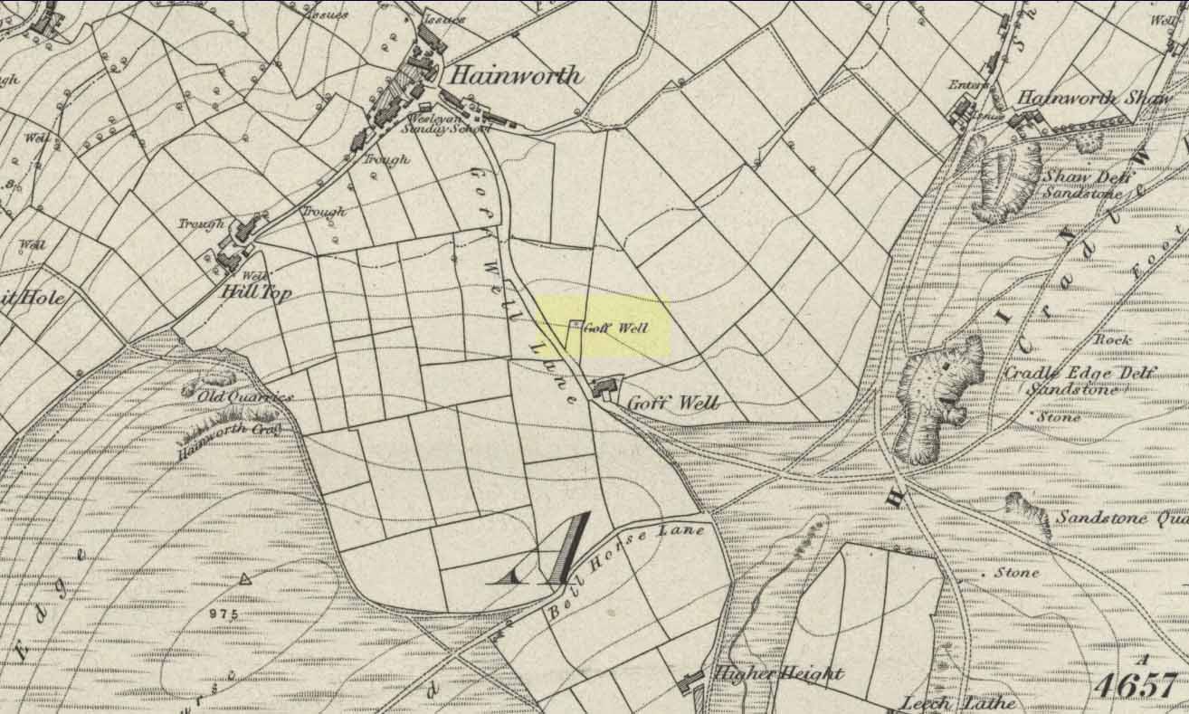
Various ways here. From Keighley, go up the A629 Halifax Road, first left after the Ingrow West train station, uphill; then turn right, and up the long, cobbled, zizaggy road past the little hamlet of Hainworth and uphill till you reach the solitary farmhouse of Goff Well Farm (where its friendly owners can sell you organic fresh eggs!). It’s the field just before here on your left (if you reach the Guide Inn pub further uphill by the crossroads, you’ve gone too far). Alternatively start at the Guide Inn pub and walk across the road and downhill till you reach the farm. It’s in the first field on the right just past it.
Archaeology & History
Little is known about the history of this water source. The first description of it seems to be in 1852. Harry Speight (1898) mentions it briefly when he talks about the holy wells of the locale, saying simply:
“Goff Well, close to the road on Harden Moor leading to Hainworth, has given name to a neighbouring farm, but the purpose or virtues of this water are not now known.”
Goff Well on 1852 OS-map
Today the well is much overgrown and in need of attention. It’s near the bottom corner of the field where the larger of the elder tree grows (the witch’s tree par excellence) and could do with being cleaned out. When the owner of Goff Well Farm, Barry, took us to see the site, the waters couldn’t be seen but we could hear the water running clearly just beneath the surface, so it just needs a few hours work to bring it back into life. Twouldst do the land and the genius loci the world of good!
The very name of the well is something of an anomaly. There are several possibilities and we (as yet) cannot say which is the more likely derivation. We know in northern dialect that Goff is a simpleton or fool, and although we can apply that definition in some cases, it’s unlikely to apply here. If we could ascertain there was ever an apple tree growing here, the mystery would be solved, as a goff was an old word used for the common apple. In West Yorkshire dialect the word was also used to denote “a hammer worked by water-power”; aswell as it being a corrupted form of the word ‘God.’ Take your pick!
Folklore
The early Victorian historian William Keighley (1858) thought Goff Well was named after a long-forgotten hermit called Goff who, at some time in the past, gave his name to the old hamlet of Hermit Hole, a half-mile downhill from this water source. Mr Keighley wrote:
“On the skirts of Harden Moor is a farmhouse known by the name of Goff Well; and as goff is said to be the Danish word for red, it would probably be no great stretch of the imagination to suppose that the hermit was so named on account of his red hair, and the spring or well designated after him from the frequency and sanctimonious nature of his visits.”
But this is pure supposition on Keighley’s part — nice idea though it is! The only tangible piece of folklore we have is that the well “was a famous resort of gypsies before the moor was enclosed in 1861.” (Speight 1898)
References:
Keighley, William, Keighley, Past and Present, Arthur Hall: London 1858.
Speight, Harry, Chronicles and Stories of Old Bingley, Elliott Stock: London 1898.


")