Stone Circle (destroyed): OS Grid Reference – NN 9424 5871
Archaeology & History
Missing from the primary surveys of Burl (2000) and Barnatt (1989), a mention of this long lost site was made by local historian Hugh Mitchell (1923) in his survey of the area. He told that,
“On the east side of the Moulin road beyond the Hydro Hotel a knoll and a clump of trees will be noticed on the right, inside the Hydropathic grounds; this knoll is known as the Cnoc Dubh, or “Black Knoll” and still bears an uncanny reputation as being an old site of Pagan worship. There was at one time a stone circle on it, but the stones are said to have been broken up, fully 100 years ago, to build the old farmhouse of Balnadrum.”
Something ancient was there, obviously, as it was mentioned in another earlier account—albeit just a tourist guide of Atholl—which said that, on
“the knoll known as Knock-Dhu, within the (Pitlochry Hydro) grounds, are the remains of a pre-historic fort, now overgrown with pine trees.”
References:
Anon., Atholl Illustrated, L. Mackay: Pitlochry c.1910.
Dixon, John H., Pitlochry Past and Present, L. Mackay: Pitlochry 1925.
Mitchell, H., Pitlochry and District: Its Topography, Archaeology and History, L. Mackay: Pitlochry 1923.
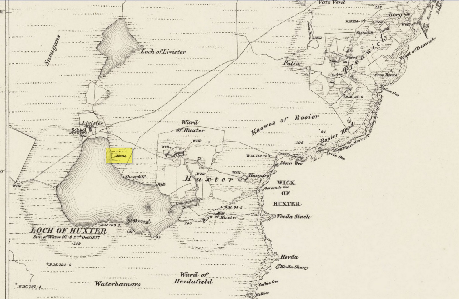
Standing Stone (destroyed): OS Grid Reference – HU 5577 6237
Archaeology & History
Site shown on 1882 map
Highlighted on both the 1880 (25-inch) and 1882 (6-inch) Ordnance Survey maps, this is another one of our ancient stones that has bitten the dust, so to speak. Local folk said that it stood about five feet tall, but when the Royal Commission doods visited the place in 1935, it had gone. They were told that it had been “broken up for building purposes in about 1912.” No traditions were known of it.
References:
Royal Commission Ancient & Historical Monuments, Scotland, Inventory of the Ancient Monuments of Orkney and Shetland – volume 3, HMSO: Edinburgh 1946.
I’ve already added a site-profile of the standing stones that used to be close to this loch, and added to it the folklore below; but I realised that for students of water-lore, a separate profile for the loch itself is needed. For those of you who are not into water-lore, I hope you can forgive this repetition.
The loch, its associated chapel and the standing stones were visited at the end of the 17th century by John Brand, who gave a good account of the rituals performed by local people at the time. They regarded the waters here as very special indeed, with great medicinal powers. The loch had sense of sacrality whose nature was intimately tied to the repetition and regeneration of the seasons, valorizing the healing function of the waters.
By the edge of the loch stood St Tredwell’s church, outside of which was a cairn of stones. When people visited here to be cured of their various ailments, they would pick up one of them and cast it into the loch as an offering (some folk would cast money), so that its waters would heal their illness. According to Mr Brand and the local minister, such cures were numerous. The narrative is truly fascinating. Brand told us that,
“nigh to the east end of which this chapel is, is held by the people as medicinal, whereupon many diseased and infirm persons resort to it, some saying that thereby they have got good; as a certain gentleman’s sister upon the isle, who was not able to go to this loch without help, yet returned without it; as likewise a gentleman in the country who was much distressed wifh sore eyes, went to this loch, and washing there became sound and whole, though he had been at much pains and expense to cure them formerly. With both which persons he who was minister of the place for many years was well acquainted, and told us that he saw them both before and after the cure. The present minister of Westra told me that such as are able to walk, use to go so many times about the loch as they think will perfect the cure, before they make any use of the water, and that without speaking to any, for they believe that if they speak this will marr the cure: also he told that on a certain morning not long since he went to this loch and found six so making their circuit, whom with some difficulty he obliging to speak, said to him they came there for their cure.”
For the curing of sore eyes, the loch was specifically resorted to at Easter and during Lent. Traditions such as these are found at other lochs in Scotland and at lakes in many other parts of the world.
Another interesting feature related to the element of Kingship; for the waters of the loch were said to turn red when anything important was going to happen to a member of the royal family.
St Tredwell herself—also known as St. Triduana—has her saints day on October 8.
References:
Banks, M. MacLeod, British Calendar Customs: Orkney and Shetland, Folk-lore Society: London 1946.
Black, G.F., Examples of Printed Folk-lore Concerning the Orkney and Shetland Islands, Folk-Lore Society: London 1901.
Brand, John, A Brief Description of Orkney, Zetland, Pightland Firth and Caithness, George Mosman: Edinburgh 1701.
Eliade, Mircea, The Sacred and the Profane, Harcourt: New York 1959.
Fergusson, Robert M., Rambling Sketches in the Far North, Simpkin Marshall: London 1883.
MacKinlay, James M., Influence of the Pre-Reformation Church on Scottish Place-Names, William Blackwood: Edinburgh 1904.
Standing Stones (destroyed): OS Grid Reference – HY 497 509
Archaeology & History
These long lost standing stones most probably played a part in some ritual acts performed by the Orkney people until relatively recent times. Whilst their simple description doesn’t tell us this, the folklore of the adjacent body of water strongly suggests it. The stones were visited at the end of the 17th century by the antiquarian John Brand (1701) from whom we gain the only known account. He told that,
“At the north-east side of (St Tredwell’s) loch, nigh to the chapel, there is a high stone standing, behind which there is another stone lying hollowed in the form of a manger, and nigh to this there is another high stone standing with a round hole through it, for what use these stones served, we could not learn; whether for binding the horses of such to them as came to the chapel, and giving them meat in the hollow stone, or for tying the sacrifices to, as some say, in the times of Pagan idolatry, is uncertain.”
Several other hold stones are found in Orkney, some of which had lore that was thankfully recorded. We don’t know when these stones were torn down, but there is the possibility that they may have been cast into the loch alongside which they stood.
Folklore
An intriguing piece of folklore relates to the adjacent St Tredwell’s Loch, right next to the stones. The loch was known of far and wide as possessing great healing properties which Mr Brand told to be distinctly pagan in nature. St Tredwell’s church had a cairn of stones by its side and those who visited here would pick one up and cast it into the loch as an offering (some folk would cast money), so that its waters would heal that person’s ailment. According to Brand and the local minister, such cures were numerous. The narrative is truly fascinating. Brand told us that,
“nigh to the east end of which this chapel is, is held by the people as medicinal, whereupon many diseased and infirm persons resort to it, some saying that thereby they have got good; as a certain gentleman’s sister upon the isle, who was not able to go to this loch without help, yet returned without it; as likewise a gentleman in the country who was much distressed wifh sore eyes, went to this loch, and washing there became sound and whole, though he had been at much pains and expense to cure them formerly. With both which persons he who was minister of the place for many years was well acquainted, and told us that he saw them both before and after the cure. The present minister of Westra told me that such as are able to walk, use to go so many times about the loch as they think will perfect the cure, before they make any use of the water, and that without speaking to any, for they believe that if they speak this will marr the cure: also he told that on a certain morning not long since he went to this loch and found six so making their circuit, whom with some difficulty he obliging to speak, said to him they came there for their cure.”
The reason that I’ve included this folklore to the site profile of the monoliths is that, at some time in the early past the stones would most almost certainly have played some part in the ritual enacted at the loch by which they stood. The building of Tredwell’s chapel was, quite obviously, an attempt to mark the place as christian in nature; but in such a remote region, old habits truly died hard. Of particular interest in the rituals described here is the element of silence. It’s fascinating inasmuch as it’s an integral ingredient in various ritual magick performances in different parts of the world. Even in some modern magickal rites, this is still vitally important. It’s a tradition also found at other lochs in Scotland and at lakes in many other parts of the world.
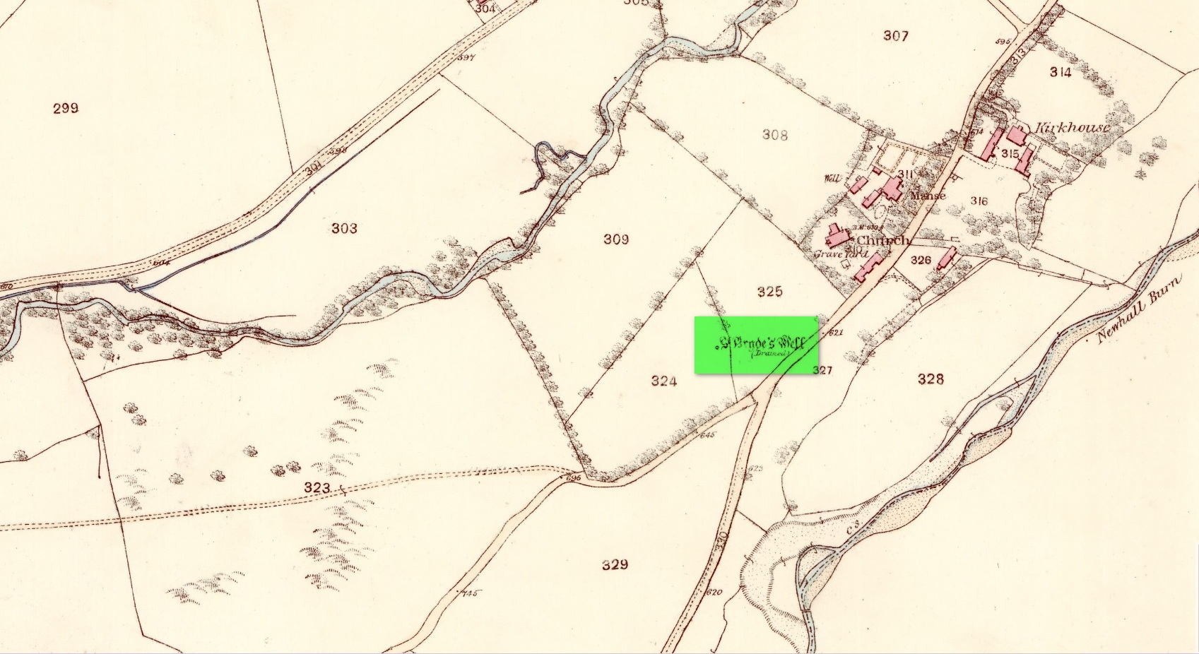
Holy Well (destroyed): OS Grid Reference – NT 3190 3339
Also Known as:
St Bryde’s Well
Archaeology & History
Site shown on 1858 map
Two hundred years ago, located halfway between Traquair’s present parish church and that of the demolished (apparently) 12th century church of St. Bride to the southwest, were the flowing waters of this once sacred water source. But it’s long since been destroyed. It was drained sometime prior to when the Ordnance Survey lads came here in 1856 and its water taken to supply the nearby manse. Subsequent surveys by the Royal Commission (1967) and Mr & Mrs Morris (1982) affirmed its demise. It was listed in the early Scottish holy well surveys, without comment, and I can find no local history accounts of the place.
References:
Hallen, A.W. Cornelius, “Holy Wells in Scotland,” in The Scottish Antiquary, volume 9, 1895.
Royal Commission on the Ancient & Historical Monuments, Scotland, Peeblesshire – volume 2, Aberdeen University Press 1967.
Walker, J. Russel, “‘Holy Wells’ in Scotland,” in Proceedings of the Society of Antiquaries of Scotland, volume 17,, 1883.
Acknowledgements:Huge thanks for use of the Ordnance Survey map in this site profile, reproduced with the kind permission of the National Library of Scotland.
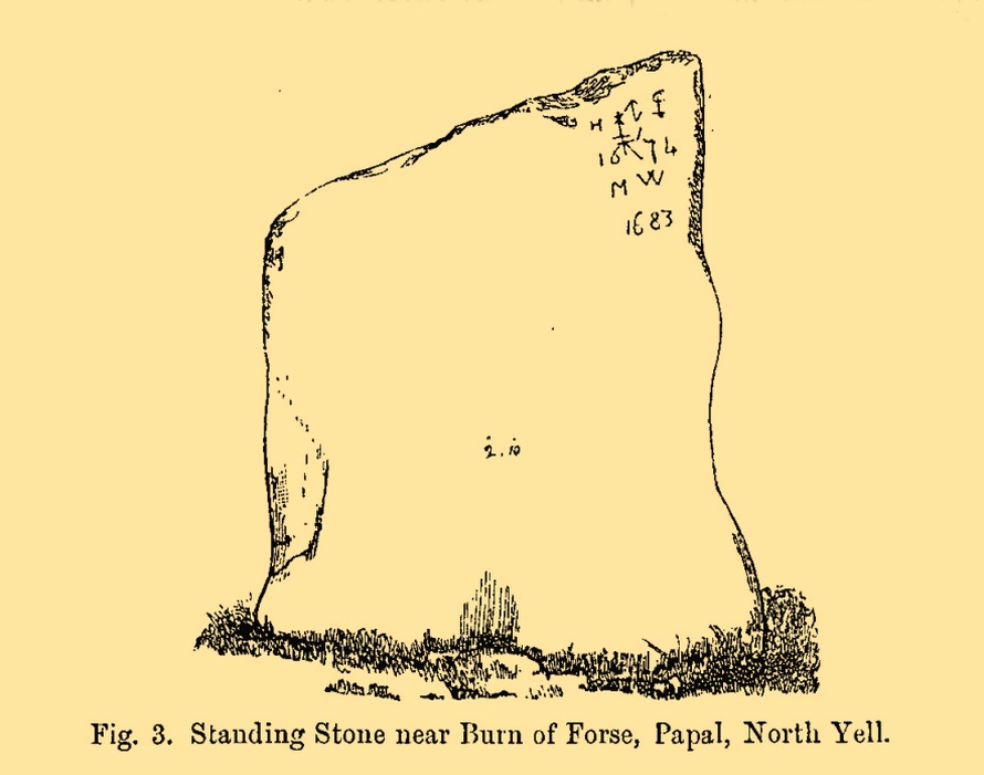
Standing Stone (destroyed): OS Grid Reference – HP 5378 0425
Also Known as:
The Brough
Archaeology & History
This standing stone formerly stood close to the Burn of Forse, otherwise known as the Garth of Papal in the far north of the island. Described briefly in J.T. Irving’s (1887) essay on the prehistoric remains of the area, the upright was obviously of local stone being,
Papil stone (PSAS 1887)
“a broad flat slab, slightly lower at one side than the other and measuring 4 feet 2 inches in greatest height by 2 feet 10 inches in width, and varying from 18 inches to 6 inches in thickness. In one corner were the initials H I 1674 and M W 1683, with an old merchant’s mark, or something of that description… The late Dr Hunt of the Anthropological Society, dug under it in 1865, with the result that it was left to fall down, and be eventually broken up for building material to be used in the walls of a new school-house.”
Folklore
Irving (1887) told us that, “there is a tradition that a queen who came in a ship to Papal died there, and was buried beneath this stone.”
References:
Irving, J.T., “Notes on some Prehistoric Burial-places and Standing Stones in the Island of Yell, Shetland”, in Proceedings Society Antiquaries, Scotland, volume 21, 1887.
Royal Commission Ancient & Historical Monuments, Scotland, Inventory of the Ancient Monuments of Orkney and Shetland – volume 3, HMSO: Edinburgh 1946.
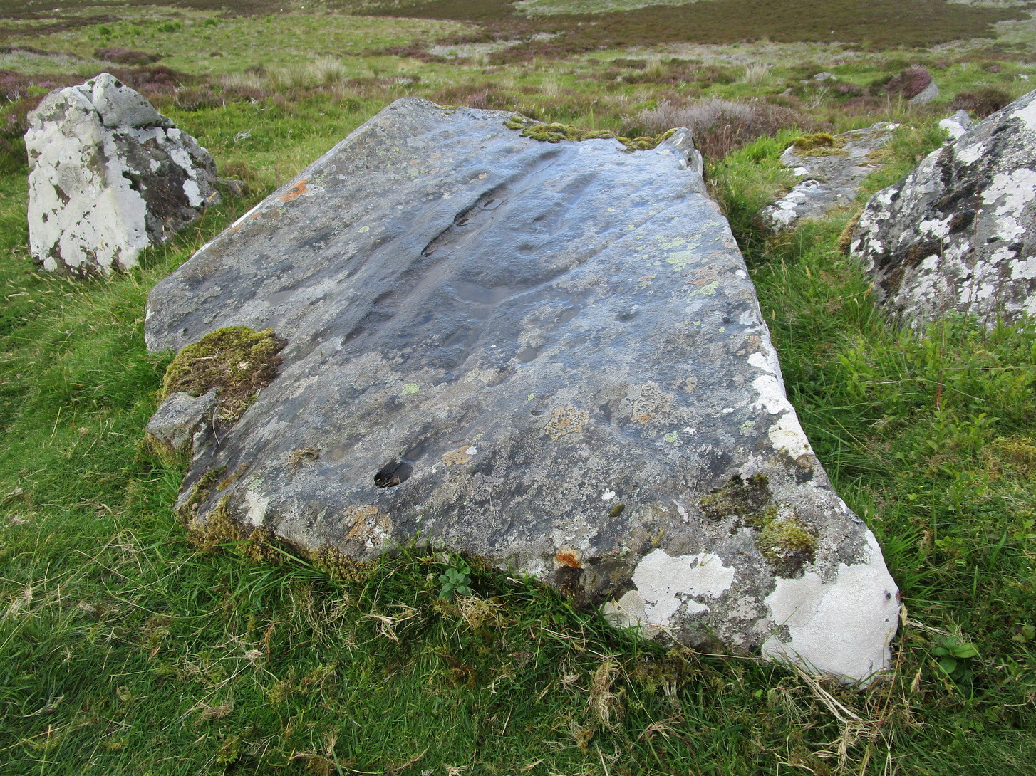
Legendary Rock (destroyed): OS Grid Reference – HP 5223 0467
Archaeology & History
Whilst classifying this as a “legendary” rock, it was as much a functional stone that played an integral part of local village life in the 19th century and, most probably, way before that. This large stone possessed a large cavity in the shape of a giant human footprint, measuring 12 inch by 4 inch. It could be seen “above the Deeks of Bracon, North Yell, up Hena”, but when first described in 1865, it was said to be “no longer in existence.” Despite this, when an Ordnance Survey dood came looking for it in 1969, he reported it as “still in existence” and known of by local people. Is there anyone in the far far north who can tell us?
Folklore
The impression of the large footprint was natural, but the use to which local people made of it is valuable when we seek to understand pre-industrial customs. The Royal Commission (1946) lads echoed the folklore handed down by J.T. Irvine from 1865, telling that,
“Formerly the people used to wash in dew or rain-water that had gathered in the cavity and stand in it to get rid of warts. The tradition was that a giant had planted one foot here and the other on a stone on the Westing of Unst.”
Healing stones with such properties can be found everywhere on Earth.
References:
Royal Commission Ancient & Historical Monuments, Scotland, Inventory of the Ancient Monuments of Orkney and Shetland – volume 3, HMSO: Edinburgh 1946.
Follow the same directions to reach either the Craig Hill cluster (3), no.4 or no.5 carvings. Once here, looking at the sloping moorland ahead of you, the elongated stone that’s closest to where the moorland slopes downhill is the one you’re after. Y’ can’t really miss it!
Archaeology & History
The sixth carving in this small close-knit cluster and, design-wise, the least impressive of the bunch. There are three distinct cup-marks on the rock: two on its more southern side and one near the middle of the stone. There may be another two cups, but these may have been part of the curious long, naturally-eroded line running along the length of the stone. Other man-made elements may have been cut into the stone, but it needs to be seen in perfect low light to tell us one way or the other.
Holy Well (lost?): OS Grid reference – SX 2258 5311
Archaeology & History
This spot is where an old field-name has preserved the memory of an all-but-forgotten holy well, known as the “Holywell Ground.” Although it may have fallen back to Earth, there are two possible spots regarding its position: i) a spring that was marked on the 1882 OS-map at SX 2258 5315, and ii) a “Well” that’s shown on the recent OS-maps (SX 2257 5306). Hence, the grid-reference I’ve given to this place is the halfway spot between them both. (it has to be pointed out that the “well” on recent maps occurs right next to an old quarry, which are well known to bring forth water sources that were previously deep underground) Whether or not Sclerder Abbey—about 400 yards west of here and only built in 1843—had anything to do with the sanctifying this well, we can but guess…
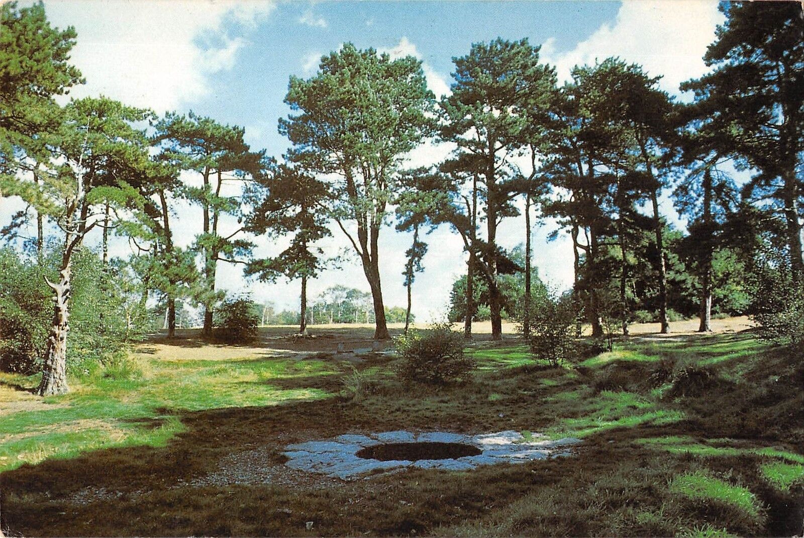
There are numerous ways to get here from all directions: i) from the west-side of Wimbledon Common, on the Robin Hood’s Way A3 road, keep your eyes peeled for the small crossroad of Robin Hood Lane and Road, obivously taking the one into the park. Keep on the dead straight Robin Hood Ride path until your hit the carpark ¾-mile on; and from here, bear sharp left (NW) for 250 yards or so, where a small slope down on your left takes you there; or, ii) from Wimbledon village side on the A219 Parkside A219 road, where the War Memorial stands, head onto the Common along The Causeway, past the Fox & Grapes going on Camp Road, then up the Sunset Road towards the carpark. And then, once again go NW for 250 yards or so, where the small slope on your left takes you there. You’ll find it.
Archaeology & History
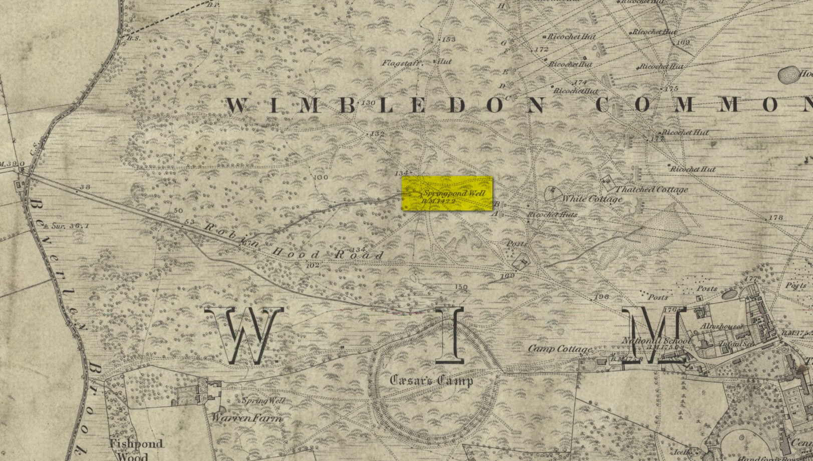
Described by William Bartlett (1865) as “the never-failing spring of water, improperly called the Roman Well”, its constant flow was severely tested in the great drought of 1976—and it kept on flowing. Only just though! It was highlighted on the early Ordnance Survey map with the plain name of the Springpond Well. The great historian and folklorist Walter Johnson (1912) gave us the best historical resumé of the site, telling that,
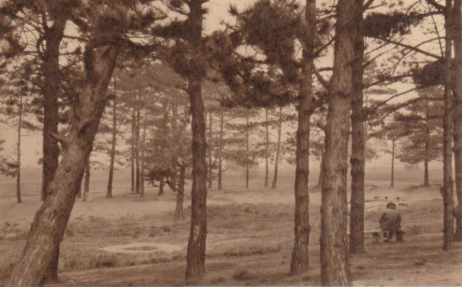
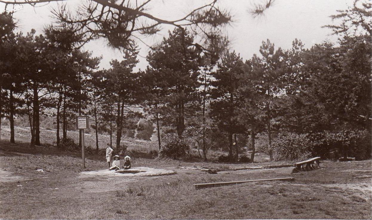
Caesar’s Well around 1900Caesar’s Well around 1911
“Caesar’s Well, formerly known as Robin Hood or Roman Well—the Springpond Well on the Ordnance Map—issues on the other side of the little watershed above mentioned, at a height of 149 feet O.D. The well lies in a little hollow, now ringed with Scottish pines. The gathering ground is the land to the east, rising to 198 feet O.D. This area is not large, but quite sufficient to maintain a permanent rill of pure water. The well, the waters of which once were deemed of special medicinal merit, was enclosed with brick in 1829, and, as the inscription tells us, refaced with granite blocks by Sir Henry W. Peek, M.P., in 1872. The outflowing waters descend to Brickfield Cottage, where they expand into a turbid duckpond; thence the course is through the yard behind the house, and along the north side of Robin Hood Road to Brook Cottage. During 1911 the “Well” proper altogether dried up, but water still issued from the stand spout a few yards below, which is supplied by an artificial boring and pipe that tap the spring at a depth of 18 feet.”
Site shown on the 1874 map
The proximity of this never-failing spring to the huge prehistoric enclosure of Caesar’s Camp just a few hundred yards to the south would indicate it was an important water source in Bronze Age times and, I’d hazard, would have been bestowed with some sanctity, as many such wells tended to be.
Folklore
James Rattue (2008) informed us that the name Robin Hood’s Well was known here in the 18th century prior to it being known as Caesar’s Well, but there seems to be no known relationship between Robin Hood and this site. However, a piece written in 1922 told that there was a lingering tradition that Julius Caesar encamped on Wimbledon Common in 51 BCE and that this folk memory was kept alive in the lore of local children who devoutly believed that the great Roman Emperor drank from the cool depths of this well.
References:
Bartlett, William A., The History and Antiquities of the Parish of Wimbledon, Simpkin Marsall: London 1865.
Hughes, John L., “Caesar’s Well, Wimbledon Common,” in Source magazine, no.9, Spring 1989.
Johnson, Walter, Wimbledon Common – Its Geology, Antiquities and Natural History, T.Fisher Unwin: London 1912.
Rattue, James, Holy Wells of Surrey, Umbra: Weybridge 2008.