This long lost holy well used to be found somewhere on the south-side of the Water of Leith, close to Powderhall, between Warriston and Broughton. References to it are minimal. Whilst Ruth & Frank Morris’ (1981) thought it might have been an alternative name of the Bonnington Mineral Spring—aka St. Cuthbert’s Well—a half-mile to the north-east, we know from John Russel’s (1933) article that it was a quite separate site; but all he could tell us was that St. Leonard’s Well was “a now forgotten mineral well”. The clearest indicator telling of its whereabouts is in John Geddie’s (1896) lovely work on the history of the Leith watercourse, where he described this “forgotten mineral spring” as being below Powderhall “beside the Water”, i.e., the river Leith. A few miles south, a crag at Arthur’s Seat was once dedicated to St. Leonard. (the grid-reference to this site is an approximation).
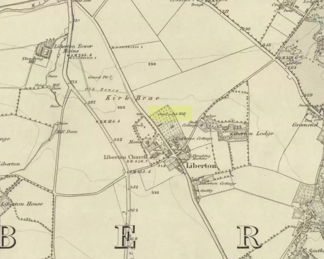
Mentioned in passing by John Geddie (1926)—who was skeptical of any ‘holy’ associations here—this was one of two holy wells in Liberton parish with the same name. Whilst one is on the northwest side of the parish, this was closer to the centre of the village on the piece of land known as the Kirk Brae. It was some 200 yards northeast of the old church at the crossroads, originally dedicated to St. Cuthbert, whose feast day was March 20 — or right next to the Spring Equinox, perhaps when the waters here had greatest virtues.
Highlighted on the earliest OS-map of the region, little is known of it via the written records. Our primary account comes from the Name Book of 1852, where they told:
“An ancient well, known by more ancient settlers as the Christening Well, from the circumstance of this being the only one, from which water was taken in Ancient times for Baptizing; the water being considered the purest; hence it was dedicated to the Virgin.”
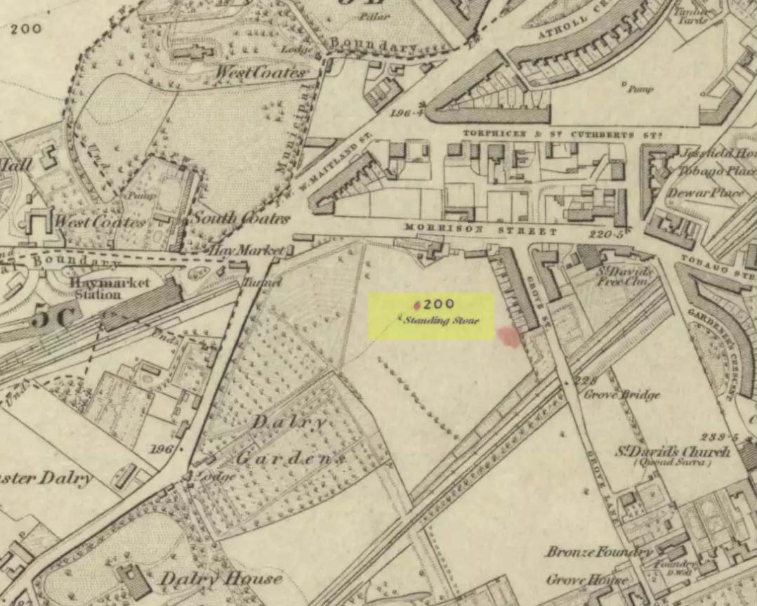
Standing Stone (destroyed): OS Grid Reference – NT 2421 7317
Archaeology & History
Standing Stone of Dalry, 1853
Not far from Edinburgh city centre, heading out towards Haymarket just off Morrison Street where the large car-park is, once stood a possible prehistoric standing stone. Not that long ago either… It was highlighted on the OS-map of 1853, but had been destroyed by the end of the 19th century when the Industrialists cut railway lines across its ground. The stone was shown in non-antiquated lettering, indicating there was no tradition of its prehistory. It may have been part of a folly, but I can find no account to indicate this. Do any Edinburgh historians or researchers know anything more about it? Help!
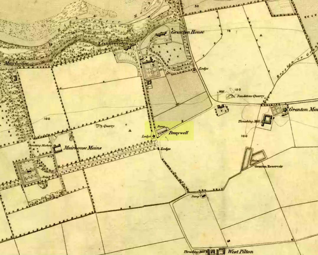
On the 1853 Ordnance Survey map of Granton we are show the house and place-name of Pennywell with a ‘pump’ adjacent to it. Sadly we don’t have as rich a history of the place as its namesake at Newington. Its earliest written appearance seems to be in 1812. A few years later, in the OrdnanceName Book of the area, it was recorded that,
“Two cottages on the property of Sir John McNeil the name appears to be derived from a well which was formerly situated at the North east end of the houses where one Penny was paid for a draught of water.”
Remembered as a watering place for horses, the old Scots word ‘penny’ may be behind this old name, in terms of it giving the animals and locals their water supply. Stuart Harris (1996) thought that this Penny Well may have been the long lost St. Columba’s Well in the parish of Cramond.
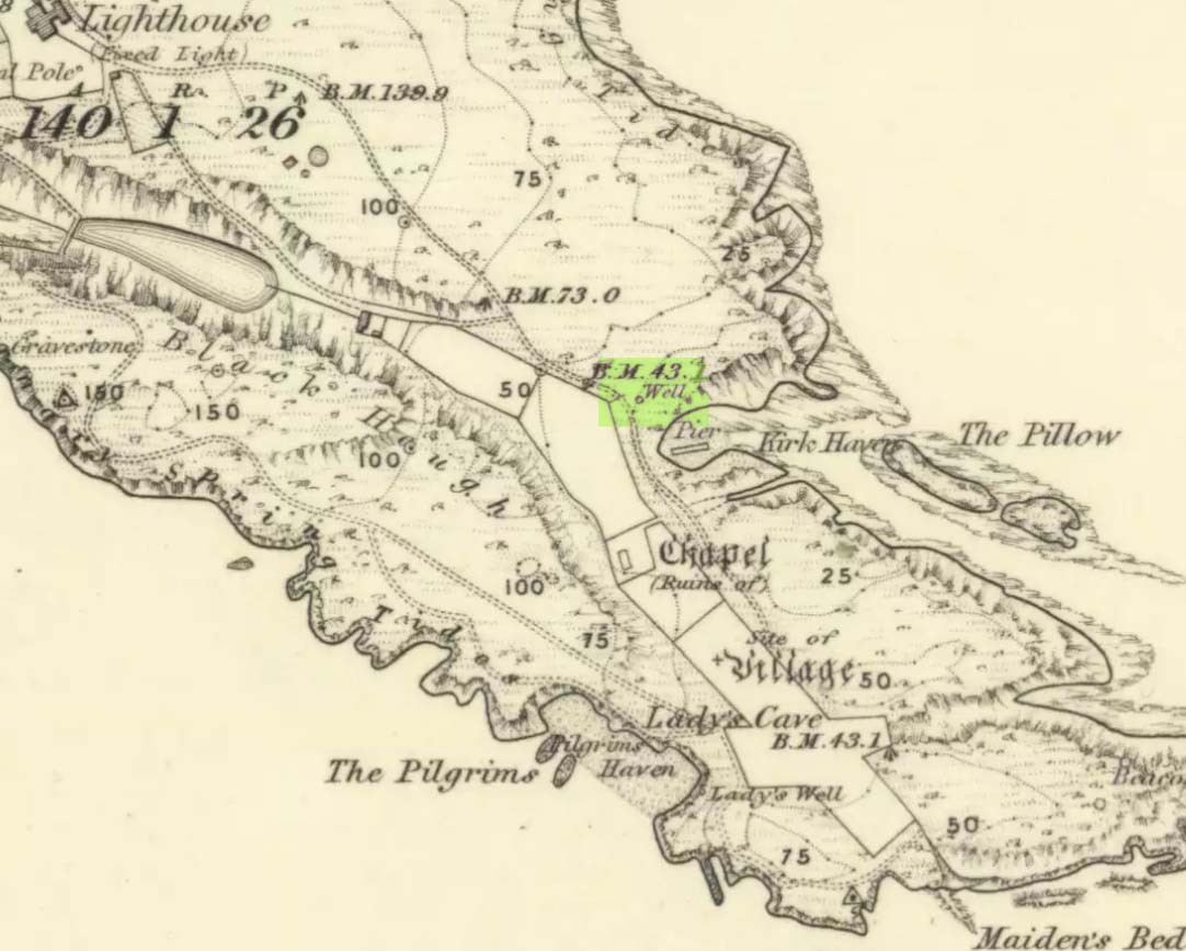
This seems to be the only ‘St John’ dedication on the Isle of May: a small island littered with more saint’s names, seemingly, than Iona and Lindisfarne combined! Illustrated on the 1855 OS-map, without name—and on the present-day large-scale OS-maps too, 20 yards or so from its 1855 position—the standard archaeo-historical records say nothing of the place. Thankfully antiquarian and folklore accounts have preserved evidence of its title. When the Victorian traveller Thomas Muir (1868; 1883) visited the Isle of May, he told how the islanders struggled to maintain a good water supply during a drought there in the 1860s. St. John’s Well was, he told,
“A pump standing by the path above Kirk Haven. The water good, but a little brackish. During all the drought of this summer we pumped water out of this well to supply our cattle.”
After Æ. J.G. Mackay’s (1896) visit to the island he told that here, along with the other holy wells on May,
“their brackish waters have lost the magic virtue they were credited with in early christian, possibly in pagan times.”
In more recent times it was described in W.J. Eggeling’s (1985) natural history survey. St. John’s Well was,
“the well within the high, cylindrical, whitewashed wall-surround lying across Haven Road from the Coal House. Also known as the Pump Well. It is a guiding mark for boats entering Kirk Haven.”
Folklore
St. John’s Day (June 24) was the christian name given to the traditional Midsummer Day, or days, around which good heathen festivals occurred; but we can find no ritual accounts of activity specific to this Well. Help!
References:
Dickson, John, Emeralds Chased in Gold; or, The Isles of the Forth, Oliphant: Edinburgh 1899.
Muir, Thomas S., The Isle of May – A Sketch, Edinburgh 1868.
Muir, Thomas S., Ecclesiological Notes on some of the Islands of Scotland, David Douglas: Edinburgh 1883.
Simpkins, John Ewart, Examples of Printed Folk-lore Concerning Fife, with some Notes on Clackmannan and Kinross-shires, Sidgwick & Jackson: London 1914.
In John Dickson’s (1899) fine work on the history and antiquities of the Forth islands, he describes a number of all-but-forgotten holy and medicinal wells that could be visited in the 19th century—this one included! It was highlighted, without name, on the 1855 OS-map of the island, a short distance west of the curiously named Holyman’s Road. Aerial views of it today seem to indicate that the well was surrounded by walling, which may have been an old well-house—although the archaeological record here is silent. Mr Dickson told us:
“St. Andrew’s Well, beside the Altar Stones, contains the best water on the May and is entirely used for domestic purposes. This spring frequently dries up during the summer months and, in these circumstances, the islanders obtain a supply from Crail.”
Although it is still shown on modern large-scale OS-maps (as ‘St Andrew’s Well’), its present condition is unknown. If this has become boggy and overgrown, it is a sure case for renovation, despite its desolate geography; and especially considering that St Andrew is the patron saint of Scotland, whose festival date is November 30 (thought originally to have been Samhain, or Halloween—the old heathen New Year’s Day). If any visitor or islander could send us photos of the site, that would be awesome!
References:
Dickson, John, Emeralds Chased in Gold; or, The Isles of the Forth, Oliphant: Edinburgh 1899.
Muir, Thomas S., The Isle of May – A Sketch, Edinburgh 1868.
Muir, Thomas S., Ecclesiological Notes on some of the Islands of Scotland, David Douglas: Edinburgh 1883.
Simpkins, John Ewart, Examples of Printed Folk-lore Concerning Fife, with some Notes on Clackmannan and Kinross-shires, Sidgwick & Jackson: London 1914.
Taylor, Simon & Markus, Gilbert, The Place-Names of Fife – volume 3, Shaun Tyas: Donington 2009.
Holy Well? (destroyed): OS Grid Reference – NT 27534 75794
Archaeology & History
Despite this site having a number of albeit brief literary references, from the early 19th century onwards, the history and traditions of this Well are very scant indeed. It figures in various texts that detail the historical ‘Battle of Leith’, but there is little additional information in such tomes. Even local history works pass it by with brevity.
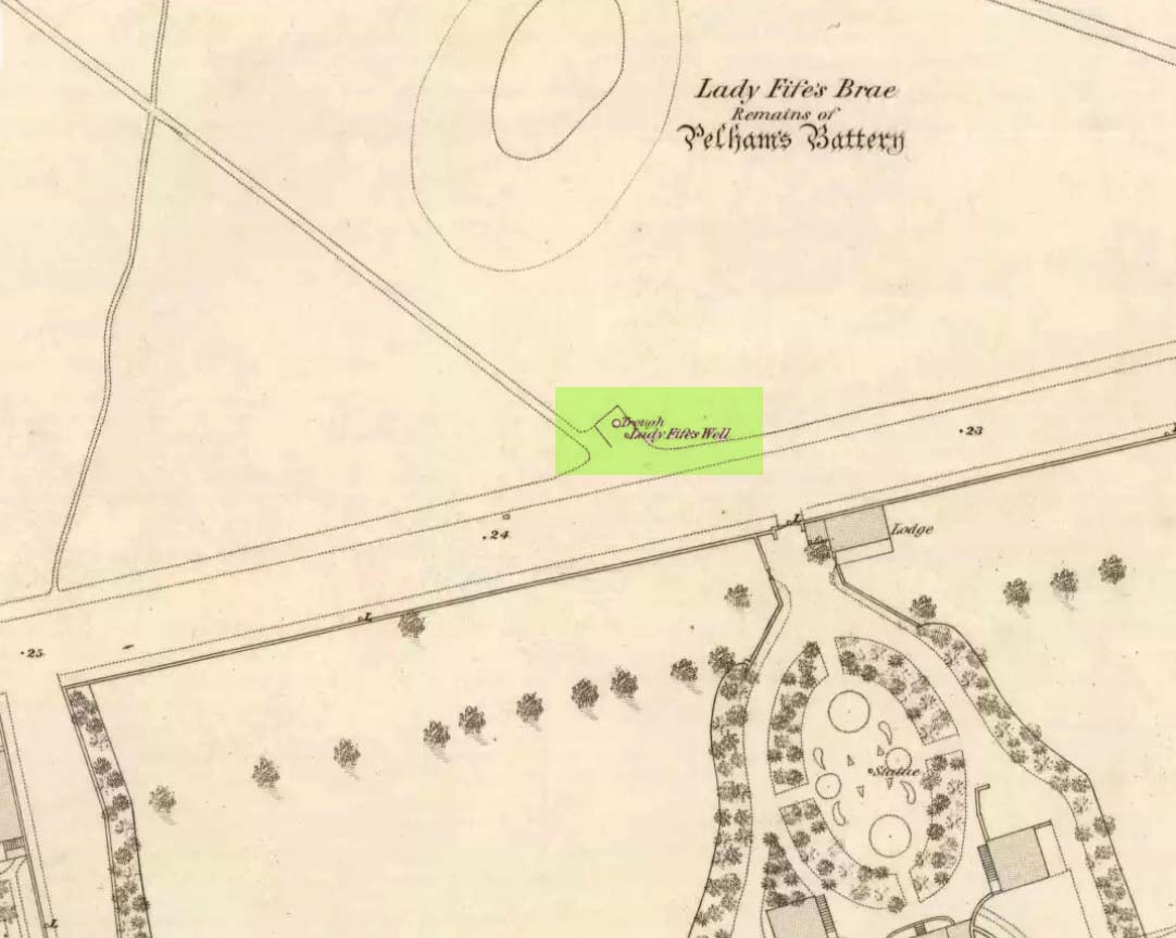
Lady Fifes Well on 1852 mapLady Fifes Well on 1853 map
Its present name derives from the Countess of Fife who, in the 19th century, lived in the nearby mansion of Hermitage House (and who also grafted her name onto the nearby mound of Lady Fife’s Brae); but this title seems to have been grafted onto the earlier ‘Ladie Well’, implying it had a dedication to St. Mary or more probably an earlier heathen female spirit at the waters. Although it is shown on the OS-maps of 1852 and ’53, and described in Grant’s 1883 work as being there in his time, all subsequent maps after this date seem to indicate that it had gone.
All that we know is that the waters ran into a small stone trough and that Lady Fife enjoyed her evenings here, partaking of the waters.
Healing Well (destroyed): OS Grid Reference – NT 2511 7322
Archaeology & History
Like many others in the city centre, this old well has long since passed into history. Said by Stuart Harris (1996) to have been “about twenty-five yards east of the eastern corner of Lady Lawson Street”, the Victorian writer Alison Dunlop (1890) told it to be by “a narrow close and an outside stair gave (which) entrance to the Court-house.” It was the focus of much social activity in ages past; and although a number of public wells could be found in this part of the city, south of the Castle, the Westport Well was the most renowned. Miss Dunlop told that,
“…its waters (were) of excellent repute (and) had to satisfy the necessities of all the inhabitants of the district. The early morning never failed to see a long line of water-stoups stretching from it in either direction like the queue at a French theatre door. Not so quiet, however, for tongues, mostly feminine, wagged freely, and the ‘Waal’ news and gossip were then the equivalent for a racy morning newspaper.”
According to her account, the patience of the people collecting the water was exemplary:
“All crowding-in was fiercely resented; gentle and simple had to stand their turn; only the water-caddies had the abiding right of precedence, and satisfied their customers at the moderate rate of two stoupful for a penny. We have already mentioned these ancient aquarian vessels peculiar to Scotland. In the event of a marriage taking place—in which case the bride was responsible for an amount of house plenishing not considered incumbent or even fashionable now-a-days—the ‘stoups’ were invariably purchased by the intending husband. Indeed, the Weetin’ o’ the Stoups was the synonym for the last bachelor supper prior to matrimony. Such festivities are understood to be hilarious, happy, hopeful; and the weetin’ o’ the stoups in Old Portsburgh, as in Old Edinburgh, was sometimes very wet indeed.”
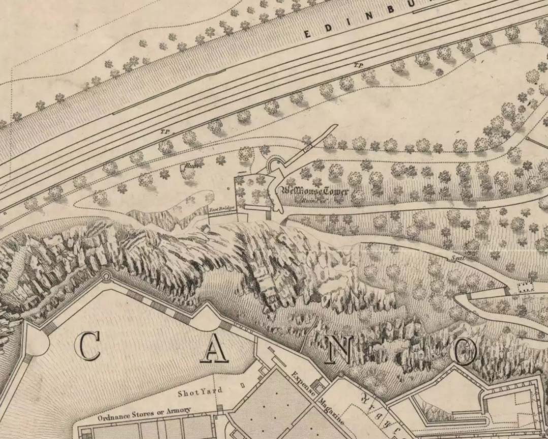
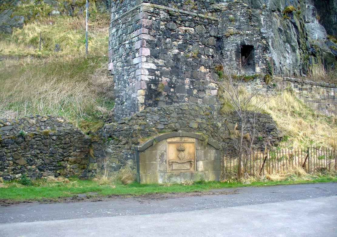
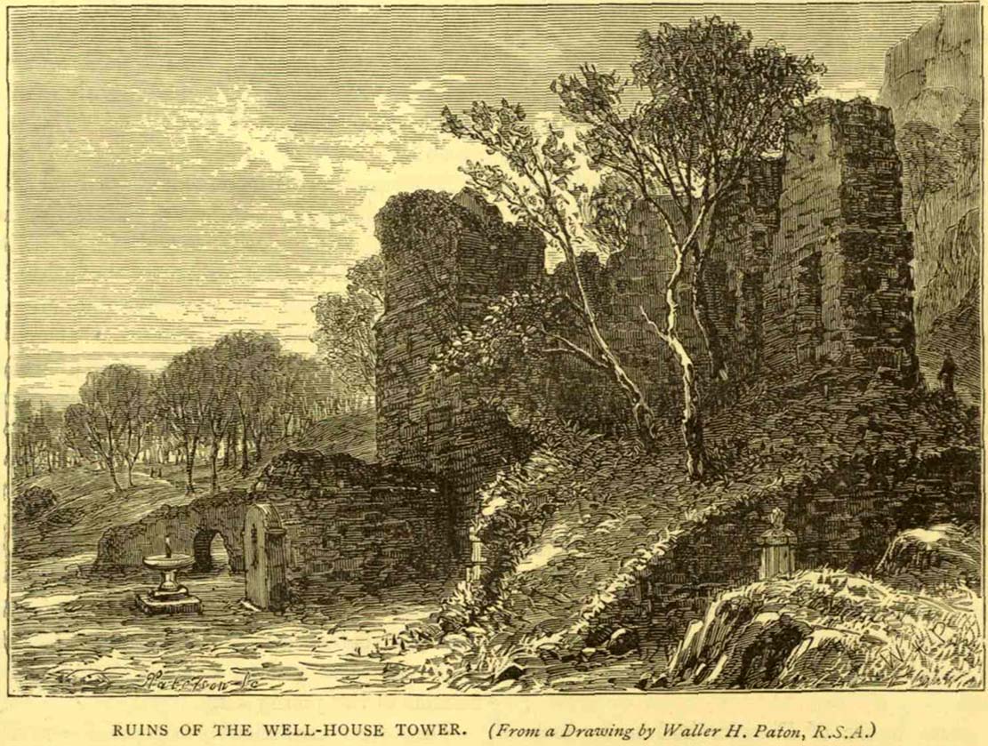
Along the more western end of Princes Street, looking up at the castle, wander into the park below and walk towards the railway line. There’s a foot-bridge over it. Once on the other side, turn right and walk along the path for just over 100 yards until you’re just about beneath the cliffs. There, in front of you, a ruinous stone building and carved faded plaque reads “St Margaret’s Well.”
Archaeology & History
The bedraggled architectural remnants we see of St. Margaret’s Well today, is not where the waters originally emerged. We must travel 2-300 hundred yards west of the present edifice, along old Kings Stables Road near St Cuthbert’s Church, for its original position. Long since gone of course…
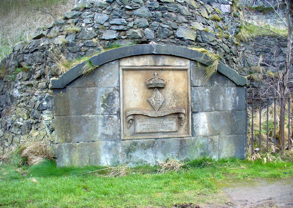
Close-up of plaqueSt Margarets, by the old ruins
The history of this holy well tends to be found scattered in a number of sources—but none give us a decent narrative of its medicinal or traditional lore. Perhaps the best was conferred in W.M. Bryce’s (1912) lengthy essay on St. Margaret’s chapel where he told:
“Of the fountain in West Princes Street Gardens, also known as St. Margaret’s, and for the protection of which the Well-house Tower was erected in 1362, no legend of a similar nature seems to have survived. It was a little flowing stream of pure water, and down to the year 1821 was utilised for drinking purposes for the supply of the garrison, in supplement of the ancient draw-well of the Castle. The earliest notice of this fountain appears in a charter by David I in favour of the Church of St. Cuthbert, dated circa 1127, in which he conveys the land under the Castle from the fountain which rises close to the corner of the King’s Garden, and along the road leading to the church. It was here, in this royal garden, beside the pellucid waters of the well which was afterwards to bear her name, that Queen Margaret, in the company of her husband and children, spent many a sunny afternoon under the shade of the rugged old Castle rock.”
St Margarets Well in 1870s
The carved plaque in front of the old tumbled-down well-house sadly hides no water anymore; merely some trash and heroin-addicts needles at the back. Best avoided.
Folklore
This Scottish Queen and consort of King Malcolm Canmore, ‘St Margaret’, had several days in the calendar on which she was commemorated. Mrs Banks (1941) told how, traditionally, her day is June 10:
“This day was appointed for her festival by papal decree, but in Scotland her day is that of her death, November 16. The festival of her translation was commemorated on June 19th.”
W.M. Bryce (1912) cited St Margaret’s Day to be generally accepted as June 19, which is closer to Midsummer and could easily be accommodated into local heathen traditions.
References:
Banks, M. MacLeod, British Calendar Customs: Scotland – volume 3, Folk-lore Society: London 1941.
Royal Commission on the Ancient & Historical Monuments, Scotland, Inventory of the Ancient & Historical Monuments of the City of Edinburgh, HMSO: Edinburgh 1951.
Healing Well (destroyed): OS Grid Reference – NT 314 735
Archaeology & History
This was one of two medicinal springs that could once be found in old Portobello village. Like its companion Chalybeate Well nearly a mile northwest, in the early 19th century those entrepreneurial types tried fashioning these waters into being a Spa Well. It didn’t really work and the fad passed after just a couple of decades—and soon after the local people had completely lost their water supply here. The best historical account of it is in William Baird’s (1898) magnum opus on Portobello. He told how the well,
“was, at the beginning of the century, situated in a garden near to the main road, where there was a well with drinking cups for the accommodation of visitors, a small sum being charged from those using it. The supply here having in some way become interrupted the spring was neglected for a time. It found vent, however, lower down and nearer to the Promenade at the foot of Joppa Lane. About fifty years ago there was a pretty large open basin, in the centre of which the water bubbled up about half a foot. It was of a red brick colour. Unfortunately on the starting of a pump on the Niddrie Bum to drain the water from the Niddrie coal pits, the supply of water was again interrupted, and this excellent mineral spring, which was strongly impregnated with oxide of iron and sulphate of lime and magnesia, ceased to flow with its former fulness.”
In 1869, the Industrialists dug into the Earth to construct their promenade and, after countless centuries, the waters of this old medicinal well finally died and fell back into the deep Earth…