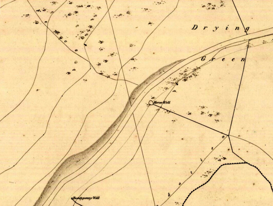
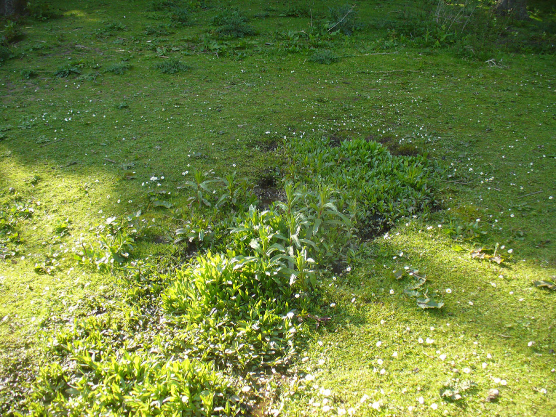
Get to the Delf Well from Duddingston and keep walking along the lochside road for 60-70 yards, where you go through the black metal gate in the fence on your left. Walk down the slope just a few yards and (drought dependent!) you’ll see an initial damp patch where the well used to arise 150 years ago; just a few yards further down the slope is the more notable spring water of the Horse Well below you.
Archaeology & History
The site is shown on the 1852 map of the area where it was later “capped” and used by the old local water authority. Thankfully the water has managed to escape and is once more feeding the birds and the land, running into the loch below. When we arrived here, a crow was drinking from the waters.
Horse Well & its herbs
Although you’d expect that this was once a watering-place for horses, the name of the well may relate to the Scottish folk-name of the herb Veronica beccabunga, generally known as Brooklime or European Speedwell, but locally called Horse-well grass—some of which seemed to be growing in the watery spring amidst the other plants. As a herb it was used in the treatment of scurvy. The history of the well however, seems all but forgotten…
Standing Stones (destroyed): OS Grid Reference – c. NT 178 655
Archaeology & History
We are uncertain about the nature and form of what was once known to be “a group of five standing stones” near the destroyed giant cairn of Harlaw, west of Balerno (which was probably built near the old trig-point at NT 1783 6594). This cluster of standing stones may have been the remains of a stone circle or a possible megalithic stone row, and it’s even been postulated as a line of possible boundary stones—but this is most unlikely.
The only known reference of the site comes from the New Statistical Account in 1845 which told:
“About a quarter of a mile to the south of the large cairn were five very tall and large stones set perpendicularly in the Earth.”
They were destroyed around the same time as the cairn in the early 1800s. Until we find further information, its exact status remains unknown. (Kaledon Naddair – are you out there?)
References:
Baldwin, John & Drummond, Peter, Pentland Place-Names, FotP: Edinburgh 2011.
Get onto the Royal Mile road (which comprises Lawn Market, High Street and Canongate) which runs down from the castle; and near the bottom of the High Street section (between North Bridge and St. Mary’s Street), on the left side of the road you’ll see a large upright monument which was formerly a stone drinking fountain. You can’t really miss it!
Archaeology & History
Found just yards away from the house of the religious lunatic, John Knox, this is one of several wells that could once be found along the old High Street, or Royal Mile, near the middle of the city. A fast-flowing spring of water was contained within this solid stone monument first built around 1675 by the King’s mason, Robert Mylne. The fountainhead was rebuilt at a later date and it supplied water for the inhabitants of the old town.
Fountain Well, Edinburgh
Fountain Well, early 19th C
It has a small semi-circular water trough at its western base and is ornamented on this and its eastern side with small mythical fauns, out of which water emerged. The local council should ensure to make the well work again, giving people clean drinking water when they need it.
The local historian Stuart Harris (1996) puzzled over the origin of the name ‘Fountain Well’, wondering whether it related to a nearby mansion, but he wasn’t too clear in his description for those who live outside of the city, where this mansion was. He wrote:
“It is…reasonable to suppose that the present well got its name from being in the general vicinity of the mansion, and that the mansion and the (Fountain) Close must have been named for another well, now lost, in the close or at its head. It is suggested in Wilson (1891), but scarcely proved, that it was the Endmyleis Well…which is mentioned in…1567.”
Bereft of natural animism, the site is more likely to be of interest to architects than the usual hydromancers and their exploratory ilk…
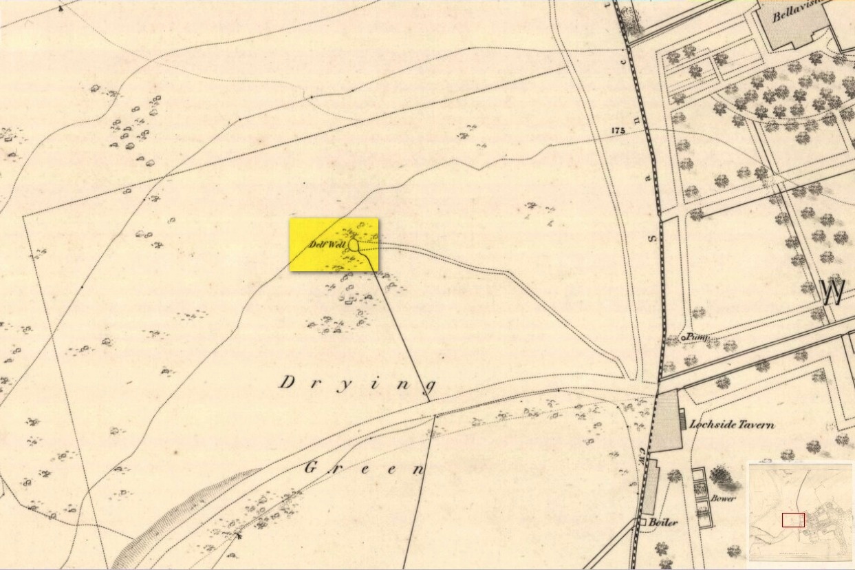
From the south-side of Arthur’s Seat at Duddingston, along Duddingston Road West, turn west along Old Church Lane. Where the houses finish there’s the loch on your left and the small car-park on your right. From here, walk above the cars and onto the small footpath. Barely 20 yards ahead, under the edges of the trees, a sealed oblong concrete water-hole is front of you. That’s the spot you’re looking for.
Archaeology & History
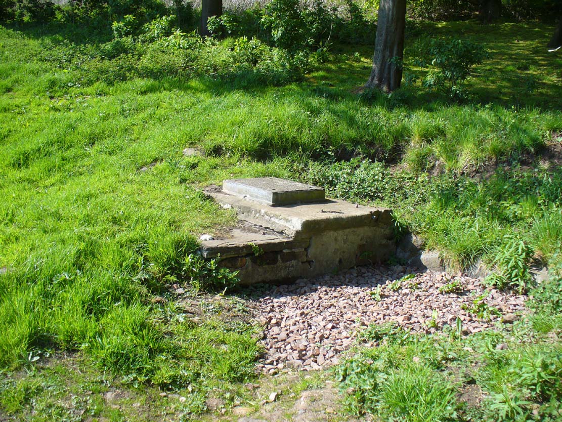
Delf Well, covered
Only for the purists amongst you, the Delf Well has fallen prey to being capped and piped away so you can no longer drink here. It is shown on the early 19th century maps of the area and was used as a water supply for the opulent South Lodge of Holyrood Park. An old metal chain — remains of which are still attached to the covering stone — once had an old cup attached, to enable walkers to drink here.
Healing Well (covered): OS Grid-Reference – NT 23894 63346
Archaeology & History
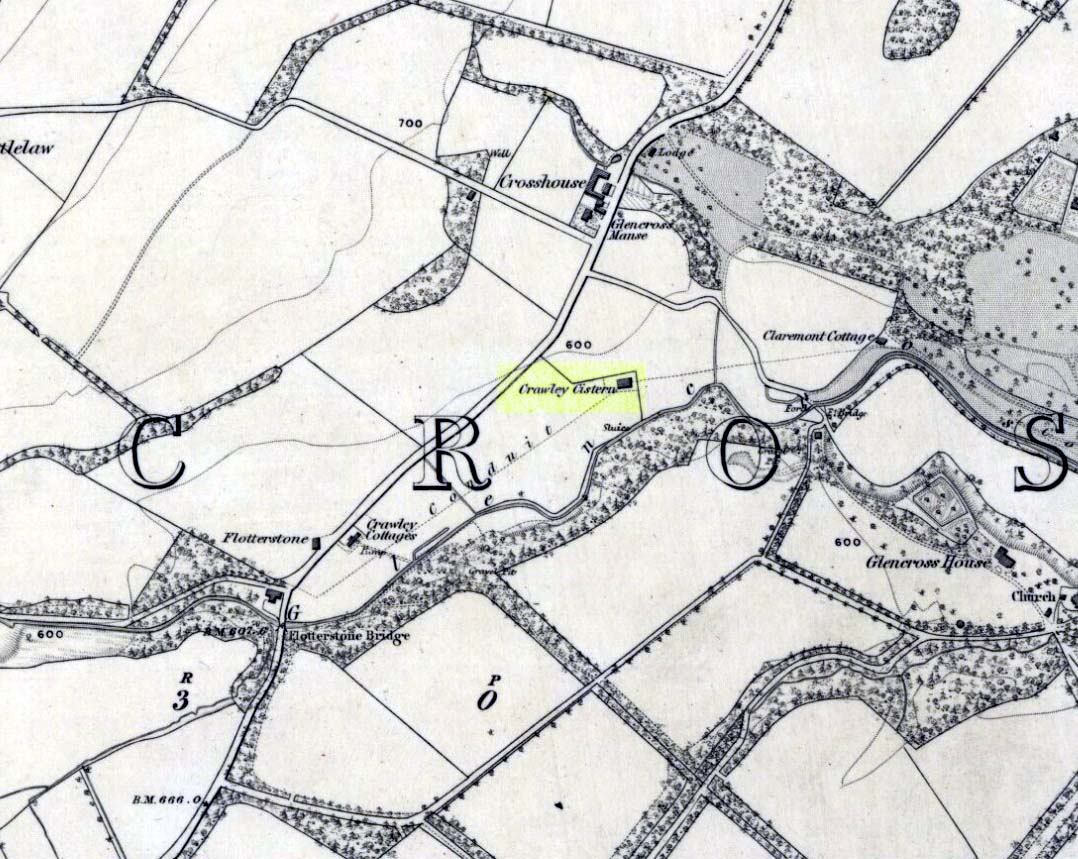
Site of Crawley Spring on the 1854 map
Once found flowing freely beneath the shadow of the prehistoric hillfort of Castlelaw, this all-but-forgotten site was thankfully recorded in Hope & Telford’s (1813) survey of Edinburgh’s natural water supply. Mr Telford said how “This noble spring rises from the bottom of a bank, at the foot of the Castlelaw Hill, at the edge of a small, low, almost marshy meadow close by the Glencorse Burn, a little way below the bridge.” Twelve years after writing this, the well had been blocked and a cistern built over it.
It was proclaimed by local people to be medicinal (though to what ailments, I cannot find), but there was an effective confirmation of some medicinal qualities in the waters following an analysis in 1810 when very tiny mineral elements were found. Mr Telford (1813) explained:
“The water is perfectly transparent and colourless, free from every smell and taste and is of excellent quality. It has, as is the case with almost all spring water, some matters dissolved in it, though in smaller quantities than common… This foreign matter consist of carbonate of lime, muriate of soda, and sulphate of lime, with an excessively minute portion of magnesium salt. The proportions of these ingredients, in each pound, are nearly:
Carbonate of Lime – 0.43 of a grain
Muriate of Soda – 0.10 of a grain
Sulphate of Lime – 0.90 of a grain
Sulphate of Magnesia – 0.05 of a grain
The carbonate of lime is dissolved by means of carbonic acid, which is not in greater quantity than is barely sufficient for the purpose. All of these ingredients are in themselves innocent to the human body; and in the quantity in which they are present in the water, do not affect its goodness. The water is perfectly soft and fit for washing, infusing tea and other domestic purposes. The water, therefore, is exceptional in every respect.”
When it came to the Crawley Spring waters being used to feed the habits of Edinburgh city, there was considerable opposition by the land-owner and local people who were, correctly, concerned that that ecosystem here would be adversely affected if the waters were to disappear. And so it was that Earth’s blood was taken from the land and the people and the animals, to benefit and feed the religion of Industrialism and ‘progress’ once more…
Legendary Stone (destroyed): OS Grid Reference – NT 1292 7840
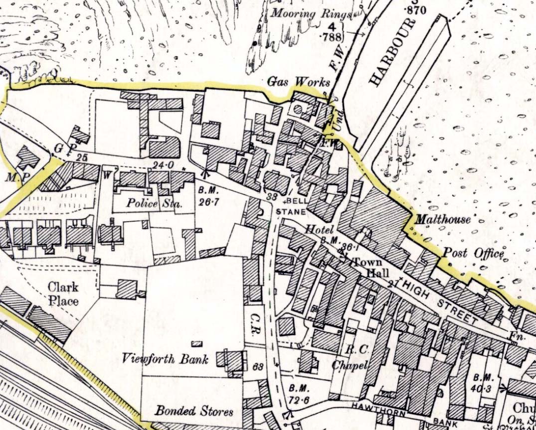
Bell Stane on 1896 map
Archaeology & History
An intriguing site that needs adding to the Northern Antiquarian due to the foraging research of the Edinburgh historian Stuart Harris (1996). Although the Bell Stane has been ascribed by the Canmore researchers to be just,
“a stone near the Mercat Cross on which the hand bell was set (rung to herald the opening of the weekly market or annual fair),”
Mr Harris dug deeper and found other references which led him to think that the site was “a conspicuous boulder or standing stone.” I have to agree with him. In his outstanding work on the historical place-names of Edinburgh and district, Harris wrote:
“The Bellstane…is noted on Ordnance Survey 1854 as the name of an object just outwith the burgh boundary and in the southwest corner of the little square that now bears the name. Whilst it has been surmised that it was a stone named for a handbell rung beside it on market days, in point of fact a burgh council meeting of 1642 (quoted in Morison’s Queensferry, p.131) records that a piece of ground hitherto waste and unused, within the burgh but near the bellstane, was to be set aside for markets and fairs in times coming; and the clear inference is that the name belonged to the stone before any markets were held near it. In absence of a reliable description of the stone or of early forms of its name, the origin of the name can only be guessed at. Similar names (of sites) in Kirknewton and Whitburn are no better documented, but the early forms of Belstane in Lanarkshire (Bellitstane, Bellistane, Belstane and Bellstane prior to 1329 and Beldstanein 1452) suggest that its first part may be Anglian ballede or early Scots bellit (from a Celtic root, ball, white), making the name ‘the stone with a white or pale patch or stripe on it’ — such as one with a band of quartz running through it. A conspicuous boulder or standing stone of this sort on this spur of higher ground above the shore would have been a useful meith or landing mark for boats making for the narrow landing place at the Binks.”
If anyone uncovers additional evidence about this Bell Stane that can affirm it as a standing stone (or otherwise), we will amend its status.
References:
Harris, Stuart, The Place-Names of Edinburgh: Their Origins and History, Gordon Wright: Edinburgh 1996.
Morison, Alexander, Historical Notes on the Ancient and Royal Burgh of Queensferry, West Lothian Courier: Bathgate 1927.
Unlike the Adam’s Well in Kent, deep daan saaaf, this northern site of the same name is not only long lost, but we can find no traditions relating it either—something of an oddity for these northern climes. It could once be found in the open meadows east of Colinton, near where now the Redford Barracks exist and was a puzzle to the regional historian Stuart Harris (1996), who could find no early accounts of the site. Although its name may relate to a local man called Adam, there are other examples of wells with this name from Kent to Scotland: the Kent example is deemed as an authentic holy well, whilst examples in Yorkshire and those in southern Scotland relate to the waters themselves being known as ‘Adam’s Ale’ or Adam’s Wine’—an old nickname for water itself!
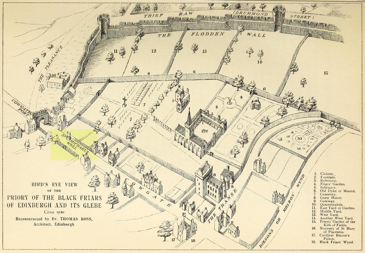
This ‘holy well of the dragon-slayer’ could once be found close to where old Cowgate meets St Mary’s Street. Highlighted on an old map of the city around 1540, and on Mr Bryce’s sketch of the old inner city at the end of the 19th century, we do not know when the Well acquired its name, but it may have been by an early group of jews, to whom the saint was important. Hereby in 1779 was listed a small piece of land called the ‘Silverwell Close’ which both Watson (1923) and Harris (1996) thought was a corruption of the St Michael’s Well, somehow. Watson (1923) explained that St Michael’s
“connection with fountains, or a ‘silver well’, is probably due to the legends of the miraculous spring of Monte Galgano in Apulia and Mont-Saint-Michele in Normandy.”
In Ruth & Frank Morris’ (1981) survey of Scottish holy wells, they report how, in the 16th century, this forgotten site was “a favourite resort” of local people. They told how,
“in 1543 an act of penance was ordered to be performed at the fountain of St. Michael.”
The greatest scattering of accounts relating to St Michael’s Well are found in the Records of the Burgh of Edinburgh, wherein we read:
29 July, 1556: “The prouest baillies and counsale foirsaid deputtis Dauid Symmer to be oursear of the well callit Sanct Michaellis well, and Johne Loch to the Mvs well, to caus tham be maid depar and preparit for watter gaddering.”
16 December, 1556: “The prouest baillies and counsale ordanis the thesaurar Alexander Park Auent the to reperell the wcllis callit Sanct Michaellis well, the Mws well, and the Stok well, and to begyn thairto at Sanct Mongois day nixt tocum, and ordanis Maister Johne Pirstoun to be oursear to Sanct Jlichaelis well, Johne Loch to the Mws well, and Alexander Barroun to the said Stok well, and quhat expens he makis thairon salbe allowit to him.”
Folklore
St Michael was a powerful mythic figure to the Muslims, Christians and Jews. In the old calendar in Scotland his festival date was September 29th and known as ‘Michaelmas’ (although other dates have been ascribed by the varying sects in other countries). In truth, this site should be highlighted for tourists, pilgrims, historians and religious followers alike due to the importance this mythic figure once held in the various pantheons.
This is the first detailed guide ever written on the holy wells and healing springs in and around the ancient city of Edinburgh, Scotland. Written in a simple A-Z gazetteer style, nearly 70 individual sites are described, each with their grid-reference location, history, folklore and medicinal properties where known. Although a number them have long since fallen prey to the expanse of Industrialism, many sites can still be visited by the modern historian, pilgrim, christian, pagan or tourist.
The book opens with two introductory chapters: the first explores the origin and nature of holy wells and what they meant to local people in earlier centuries; and the next is a comparative overview of water cults worldwide. It is an invaluable guide for any student or tourist who wants to look beneath the modern history of the city and get a taste of the more archaic customs that once belonged here…
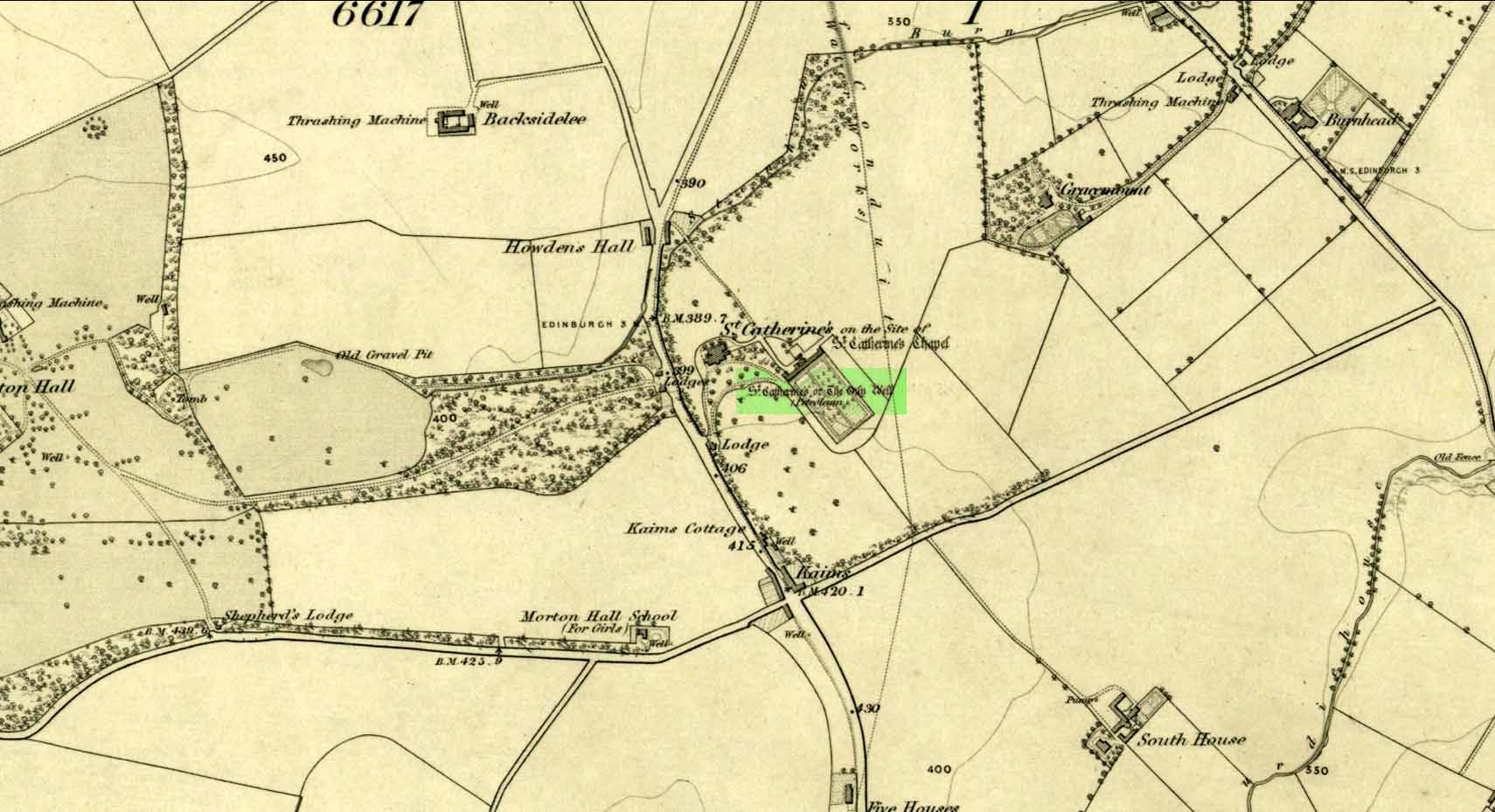
Take the A701 road from the east end of Princes Street south—down North Bridge, South Bridge, Nicolson Street, onto Liberton Road and then Liberton Gardens—towards Penicuik. 3¾ miles along, in the parish of Liberton itself, where the A701 is called Howden Hall Road, keep your eyes peeled for the turning into the Toby Carvery on your left. Park up and walk across the grass and look behind the trees ahead of you (if you can’t find it, ask the people in the pub). .
Archaeology & History
Located south of Liberton village—a few hundred yards west of the long-gone chapel erected by St. Margaret in honour of St. Catherine—this famous holy well is now in the grounds of a public house and is easily accessed. It has been described by many historians through the centuries, from Matthew Mackaile’s (1664) short work to more recent tourist guides. When the local historian George Good (1893) told about it, local lore still spoke of the old church. “These lands,” he wrote,
“belonged to a very ancient chapel dedicated to St. Catherine, which stood with its burying-ground near the modern mansion of St. Catherine’s. All trace of this chapel has disappeared, but at the end of last century its ruins were still extant. It was reputed to be the most ancient place of worship in the parish, and the ground around the chapel was consecrated for burials. Hither came annually in solemn procession the nuns from the Convent of Sciennes, a foundation due to the piety of one of the St. Clairs of Rosslyn, who may possibly have also been connected with the origin of the Chapel of St. Catherine.”
Its relationship with the world-famous Roslyn Chapel, less than 4 miles to the south, remains (to my knowledge) unproven, but it’s an association that would not be unlikely. This aside, St Catherine’s Well has a long history. Described in Hector Boece’s Latin text Scotorum Historia (1526), we have one John Bellenden to thanks for a wonderful translation into early english under the title of The History and Chronicles of Scotland in 1536. Herein one of the later editions we read, in that quaint old dyslexia:
“Nocht two miles fra Edinburgh is ane fontane dedicat to Sanct Katrine, quhair sternis of oulie springs ithandlie with sic abundance that howbeit the samin be gaderit away, it springis incontinent with gret abundance. This fontane rais throw ane drop of Sanct Katrine’s oulie, quhilk was brocht out of Monte Sinai, fra her sepulture, to Sanct Margaret, the blissit Quene of Scotland. Als sone as Sanct Margaret saw the oulie spring ithandlie, by divine miracle, in the said place, sche gart big ane chapell thair in the hounour of Sanct Katrine. This oulie has anr singulare virteu agains all maner of kankir and skawis.”
In the middle of the 17th century, its medicinal virtues were brought to the attention of the surgeon Matthew Mackaile who, in 1664, wrote:
“In the paroch of Libberton, the church whereof lyeth two miles southward from Edinburgh, there is a well at the Chapel of St. Catherine’s, which is distant from the church about a quarter of a mile, and is situate toward the south-west, whose profundity equaleth the length of a pike, and is always replete with water, and at the bottom of it there remaineth a great quantity of black oyl in some veins of the earth. His Majesty King James VI, the first monarch of Great Britain, of blessed memory, had such a great estimation of this rare well, that when he returned from England to visit his ancient kingdom of Scotland in anno 1617, he went in person to see it, and ordered that it should be built with stones from the bottom to the top, and that a door and a pair of stairs should be made for it, that men might have the more easy access into its bottom for getting of the oyl. This royal command being obeyed, the well was adorned and preserved until the year 1650, when that execrable regicide and usurper, Oliver Cromwell, with his rebellious and sacrilegious complices, did invade this kingdom, and not only defaced such rare and ancient monuments of Nature’s handiwork, but also the synagogues of the God of nature.”
St Catherine’s Well today
This historical appraisal has been echoed by other writers and is very probably accurate. Some years after Cromwell and his murderers had desecrated the land and people in this area, the well was again repaired to its former condition and slowly, quietly, people began traditionally using the site for ritual and healing once more. But over the next two hundred years, probably through religious persecution by the Church, the site was used less and less and, by the time Thomas Muir (1861) visited and wrote about it, the well-house had become “dilapidated”. A few years later when the holy wells writer J.R. Walker (1883) visited the place, he found that not only was it still,
“celebrated for the cure of cutaneous diseases, (but) it is still visited for its medicinal virtues”; and was “now carefully protected and looked after.”
In James Begg’s (1845) account of the well for the Statistical Account, he told:
“At St. Catherine’s is a well which contains a quantity of mineral oil or petroleum, obtained most probably from the spring flowing over some portion of the coal beds. This bitumous matter floats copiously on the surface of the water, and is also partially dissolved in it. The spring is reckoned medicinal by the country people, and may have some slight efficacy in cutaneous eruptions…
“At St Catherine’s, there is the famous well, before alluded to, anciently called the Balm Well. Black oily substances constantly float on the surface of the water. However many you remove they still appear to reside in this well, and it was much frequented by persons afflicted with cutaneous complaints. The nuns of the Sheens made an annual procession to it in honour of St Catharine. King James VI visited it in 1617, and ordered it to be properly enclosed and provided with a door and staircase, but it was destroyed and filled up by the soldiers of Cromwell in 1650. It has again been opened and repaired, and is now in a good state of preservation.”
The “nuns of the Sheens” who made the annual pilgrimage here were the nuns of St. Catherine’s of Sienna, in Italy! This crazy-sound journey is more than one thousand miles long and its nature and origin needs exploring in greater depth—although a “Nunnery of St. Catherine of Siena at Edinburgh” was founded in 1516 at Sciennes in Edinburgh, less than three miles away. Much easier! 🙂
It would have been more than just the healing properties of the oily waters that called the nuns across their incredible journey, but they would, no doubt, have been of considerable mythic importance. All of the early writers comment about it and seem confident in its abilities. As the Liberton historian George Good (1893) said,
“…there can be little doubt that its waters had a healing tendency. Oils when rubbed on the skin have often been found to produce most beneficial results in skin diseases. The tarry substance or petroleum mixture discovered in this spot was no doubt due to the presence of the coal or shale strata of the district. The existence of the oil-works at Straiton and elsewhere cannot fail to throw a light upon the history and peculiarities of the so-called Balm Well of St. Catherine’s, which even yet has an occasional visitor.”
This oily substance was examined for medical potential by Dr. George Wilson in the mid-19th century, who found:
“The water from St Katherine’s Well contains after filtration, in each imperial gallon, grs. 28.11 of solid matter, of which grs. 8.45 consist of soluble sulphates and chlorides of the earths and alkalies, and grs. 19.66 of insoluble calcareaous carbonates.”
I am not aware of any modern accounts of cures attached to St Catherine’s waters, but have little doubt that some people will have found it useful….
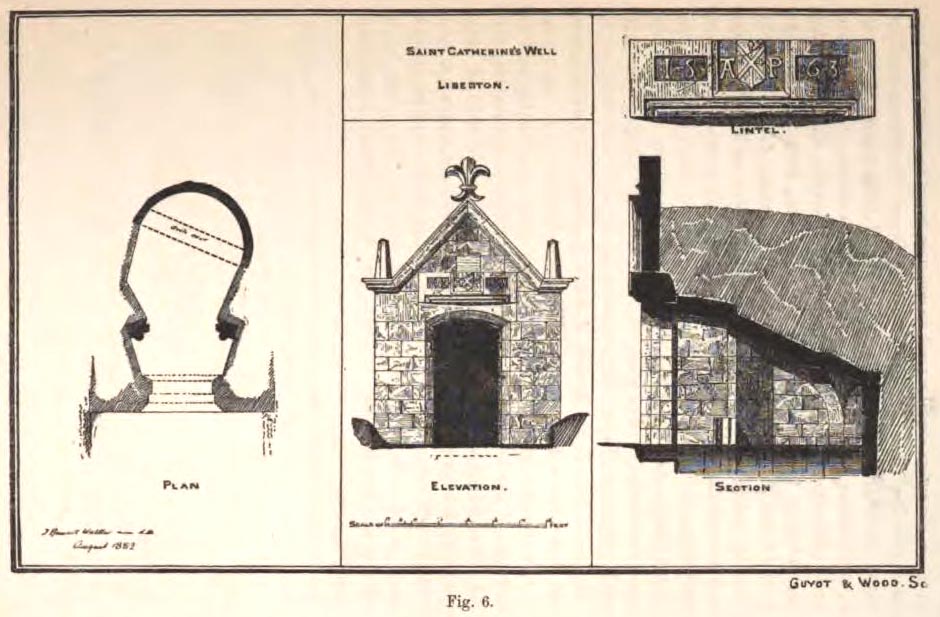
The architecture of the small well-house covering the waters would seem insubstantial, but the Royal Commission (1929) account told:
“The well is housed within a tiny vaulted structure. The Renaissance front is relatively modern, but it contains a door lintel, probably quite unconnected with the structure, on which is inscribed the date 1563 within recessed panels flanking a central panel, which contains a shield flanked by the initials A.P. The shield bears a saltire, in the sinister quarter of which is a Latin cross placed horizontally, i.e., with the shaft towards the fess point (? a merchant’s mark); the upper quarter contains a much worn object resembling a broad arrow, point uppermost.”
Plan of site in 1883
The iron-clad door is locked, as the visitor will see. Please enquire at the hotel regarding it being opened to look inside. Upon our visit here in June 2017, the waters, as in J.R. Walker’s (1883) day, were still bubbling up and were quite high, but it looked as if the inside needed cleaning. For a change, we didn’t drink the water…..
Folklore
Although various writers have posited that the oily waters are probably due related to the nearby coalfields, legend tells otherwise:
“It owes its origin, it is said, to a miracle in this manner: St. Katherine had a commission from St. Margaret, consort of Malcolm Canmore, to bring a quantity of oil from Mount Sinai. In this very place, she happened, by some accident or other, to lose a few drops of it, and, on her earnest supplication, the well appeared as just now described.” (Thomas Whyte 1792)
References:
Banks, M. MacLeod, British Calendar Customs: Scotland – volume 1, Folklore Society: London 1937.
Begg, James, “Parish of Liberton“, in New Statistical Account of Scotland – volume 1: Edinburgh, William Blackwood: Edinburgh 1845.
Muir, Thomas S., Characteristics of Old Church Architecture,in the Mainland and Western Isles of Scotland, Edmonston & Douglas: Edinburgh 1861.
Royal Commission on the Ancient & Historical Monuments of Scotland, Inventory of Monuments and Constructions in the Counties of Midlothianand West Lothian, HMSO: Edinburgh 1929.
Walker, J. Russel, “Holy Wells’ in Scotland,” in Proceedings of the Society of Antiquaries of Scotland, volume 17, 1883.
Watson, W.N.B., “The Balm-Well of St Catherine, Liberton,” in Book of the Old Edinburgh Club, volume 33, 1972.
Whyte, Thomas, “An Account of the Parish of Liberton in Midlothian, or County of Edinburgh,” in Archaeologica Scotica, volume 1, 1792.
Wilson, Daniel, Memorials of Edinburgh in the Olden Times – 2 volumes, Edinburgh 1891.
Acknowledgements:Huge thanks for use of the Ordnance Survey map in this site profile, reproduced with the kind permission of the National Library of Scotland.


 This is the first detailed guide ever written on the holy wells and healing springs in and around the ancient city of Edinburgh, Scotland. Written in a simple A-Z gazetteer style, nearly 70 individual sites are described, each with their grid-reference location, history, folklore and medicinal properties where known. Although a number them have long since fallen prey to the expanse of Industrialism, many sites can still be visited by the modern historian, pilgrim, christian, pagan or tourist.