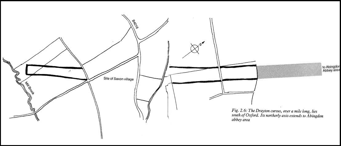
This minor cursus monument was etched into the landscape in neolithic times. Found to the south of Abingdon and close to the River Thames, one report showed finds from the site dating from 2900 BC. There is also a neolithic henge monument very close to its northern terminus and a plethora of other Bronze Age remains all round. Paul Devereux (1989) described how crop marks revealed,
“a substantial former cursus immediately to the east of Drayton: its crop marks extend southwest to northeast for a little over a mile, and are 225 feet (68 metres) wide. The cursus has a squared south end, but the northern terminus has not been found. The crop marks are not evident in the middle portion of the cursus, as it was formerly overlaid by a Saxon village. There is a plethora of other crop marks within and around the cursus… The northern section…which has a slightly different orientation to the southern segment, points squarely to the ancient heart of Abingdon.”
References:
Ainslie, R. & Wallis, J., ‘Excavations on the Cursus at Drayton, Oxon’, in Oxoniensis 52, 1987.
Barclay, A., Lambrick, G., Moore, J. & Robinson, M., Lines in the Landscape, OAU: Oxford 2003.
Loveday, Roy, Inscribed Across the Landscape, Tempus: Stroud 2006.
Pennick, Nigel & Devereux, Paul, Lines on the Landscape, Hale: London 1989.
Easy one this! Go up thru Baildon, on towards Baildon Moor over the cattle-grid. Take your first left and go up for several hundred yards past the reservoir until you reach the track on the left which takes you onto the Low Plain, Baildon Moor.
Archaeology & History
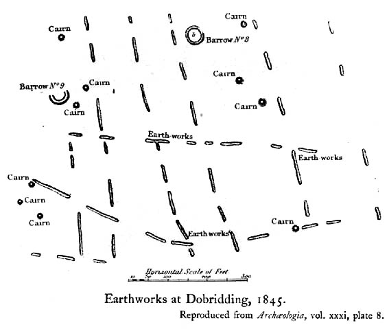
1845 plan of Cairns & Earthworks on Baildon Moor (after J.N.M. Colls)
In the year 1845, on the Low Plain on the western side of Baildon Hill, an intrepid archaeologist and historian, Mr. J.N.M. Colls, came across extensive earthworks and a number of prehistoric tombs in a very small area. Upon excavation, the ‘earthworks’ were found to be what sounds like neolithic walling running parallel to each other in a roughly north-south direction (north is the traditional direction for death). Scattered amidst these lines he found more than a dozen cairns and barrows, along with remains of “a circle, or ring.” Although the majority of what Colls wrote about has been destroyed, leaving only scanty remains of a once considerable archaeological arena, his lengthy description deserves being reprinted in full. He wrote:
“This level (the Low Plain) bears numerous traces of earthworks or other embankments running in many cases parallel with one another, at distances varying from 50 to 80 yards apart, and intersected by other works of similar construction. These earthworks can be remembered to have been from four to five feet in height; their bases nearly invariably appear to have been eight feet in diameter, composed of loose blocks of calliard, or close-grained sandstone, and earth. The greater part of the stone has been torn away to make and repair the roads of the neighbouring district; and the surface of the earth has been so nearly levelled that it is only by the scattered and disfigured remains, carefully delineated upon my plan, that any idea can be formed of their original character.
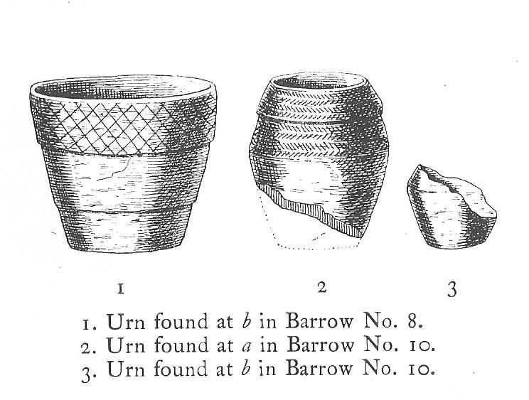
“In connection with these earthworks, and upon the north side of them, immediately above a steep fall to the next lower level (approx SE 1372 4020, Ed.), is a circle, or ring, formed originally of earthworks of precisely similar character, size and construction to those I have just described. The diameter of this ring is about fifty feet; its interior area is perfectly level; but the earthwork forming its circumference has been defaced and torn up for a considerable extent for the stone it contained. Circles of this nature have generally been termed druidical, from their presumed use as places of worship or sacrifice. I therefore opened its centre, in the hope of finding some trace of fire confirmatory of its character; and commenced clearing away a layer of peat earth, of from 10-11 inches in depth. I then found a layer of calliard boulders one-and-a-half feet in depth, the lower ones slightly burned, and resting upon a deposit of peat-ashes three inches in depth and from 2-3 feet in diameter (see Barrow No.8 in plan, Ed.). This I should have concluded to be the remains of a beacon fire, but, upon continuing the excavations, I found about three feet SSE of this deposit of ashes (at point b on the plan) a rude urn standing in an upright position, at a depth of two feet from the surface, a layer of calliard stones having been removed from above it, one of which appeared to have covered it. This urn was 12 inches in diameter and 9-10 inches in depth, of a circular or bowl shape, the upper stage of it being rudely ornamented by incised lines crossing each other at acute angles: it was filled with calcined bones (some remaining tolerably perfect), ashes and charcoal; and I selected some half-dozen of them as specimens, which Mr Keyworth, surgeon and lecturer on anatomy at York, has examined… He is of the opinion that they belonged to a very young subject, perhaps from 9-12 or 13 years of age; he thinks it possible however, that they may all have belonged to the same subject… The urn in which the were placed appears to have been rudely formed by the hand, without the assistance of a lathe; in substance about half-an-inch…it appears pretty evident that this urn has been formed of the black earth of the mountain and coal measures of which Baildon Hill is formed…
“A little to the west by south of the circle…are the almost obliterated remains of another circle (fig.9 on the plan), which I had not an opportunity of thoroughly examining; the slight traces remaining bear strong testimony of its character being similar to that of fig.8.
“Scattered over the surface of the Plain, and at irregular distances, cairns or heaps of stones, composed of bare sandstone and calliards (and not mixed with earth), frequently occur; they are generally about twenty feet in diameter and appear to have been originally 4 or 5 feet in height: these remains still require examination. In passing over them, I remarked that some of the stones of which they and the earthworks near them were constructed, had marks, or characters, but so rude that a doubt remains whether they may not have been caused by the action of the atmosphere on the softer portions of the stone.”
Urns found near Dobrudden
This final remark seems to be the very first written intimation of the cup-and-ring marked stones which can still be found amidst the grasses in the very area Mr Colls described. Sadly, much of the other remains shown in the drawing have been all but obliterated, or grown over. However, the decent concentration of cup-and-ring stones in this small area (see other Baildon Moor entries), highlights once again an associated prevalence of these carvings with our ancestor’s notions of death.
Sadly, year by year, the important neolithic and Bronze Age english heritage remains across this upland ridge are slowly being destroyed. The lack of attention and concern by regional archaeologists and local councillors, and the gradual encroachment of human erosion are the primary causative factors. Hopefully there are some sincere archaeologists in the West Yorkshire region who will have the strength to correctly address this issue. Under previous archaeological administrators, Bradford Council have allowed for the complete destruction of giant tombs, stone circles and other important prehistoric remains in their region—a habit that seems not to be curtailed as they maintain a program of footpath “improvements” on local moors without any hands-on assessment of the archaeology on the ground.
…to be continued…
References:
Baildon, W. Paley, Baildon and the Baildons – volume 1, St. Catherine Press: Adelphi 1913.
Barnes, Bernard, Man and the Changing Landscape, Eaton Press: Wallasey 1982.
Colls, J.N.M., ‘Letter upon some Early Remains Discovered in Yorkshire,’ in Archaeologia, volume 31, 1846.
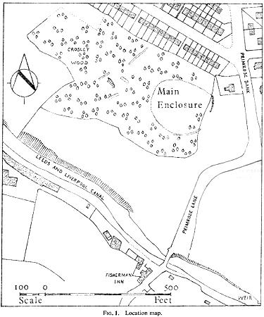
Along the main Aire Valley road (A650) between Cottingley and Bingley, turn right by Beckfoot Grammar School and wander along and up the winding road, over the canal bridge where the Fisherman’s pub is on Primrose Lane. On the slope above you amidst the scatter of trees on the left-hand side of the road is this Romano-British site (the map below should help). Check it out!
Archaeology & History
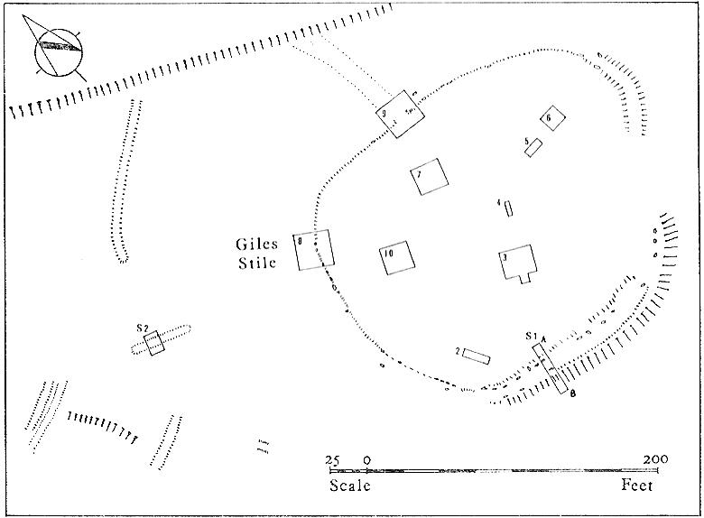
Excavated in the 1960s by the archaeologist P. Mayes, this little-known but reasonably well-preserved enclosure-cum-settlement comprises of a large oval of stone walling, double in places, about 200 feet across at its widest point.
Thought to have been constructed sometime between the Iron Age and Romano-British period, for some reason one of the stones on the western edge has long been given the name of the ‘Giles Stone’ or Stile — though nobody knows for certain why. It’s about three-feet tall with a smaller upright by its side. Any other remains that might once have been here were destroyed by the housing estate that sits above here. When Mr Mayes (1967) and his associates did their work here, cutting across sections of the walling, he told:
“The best preserved section of wall was amongst the trees on the lines of the south wall of the enclosure and included the boulders of both the inner and the outer faces of the wall. A trench 6ft by 38ft was laid out at right angles to it. The turf was removed showing the boulders of the wall with the smaller stone filling between them. On either side of the wall was a relatively small quantity of loosely tumbled stones, the angle of rest of which suggested the wall as their source of origin… Careful examination of the wall filling failed to show any sign of post settings.”
Mr Mayes said that it was “doubtful whether the Crosley Wood site, dated by one pot to the late 3rd or early 4th century AD, was ever conceived of as an occupation site.” In reference to his excavations he continued, “Certainly no evidence of settled living was found” here, concluding:
“It seems probable that the main enclosure at Crosley Wood served as a cattle pound; its defensive potential being invalidated by the scarp to the north, whilst the short stretches of external walling are all that remains of a rectilinear field system for arable or pastoral farming.”
References:
Mayes, P., ‘Excavations at Crosley Wood, Bingley,’ in Yorkshire Archaeology Journal, volume 42, 1967.
Two main ways to get here. Hmmmm….on second thoughts, one main way. My preferred route would be from Addingham (east-side) where the foot-bridge crosses the Wharfe. Walk up the path and, eventually, onto the tidgy road and bear left till you hit the trees. On the right-hand side of the road you’ll see the trees covering the crop near the edge of the river. …Otherwise, come from Ilkley, cross the river, take the first left, on a few hundred yards and left again on Nesfield Road. From here, keep walking about a mile and when you hit the village, you need to look into the field behind the first farmhouse on your left.
Archaeology & History
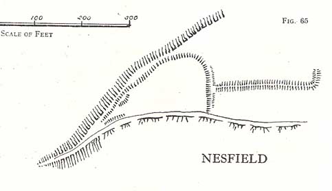
You’ll see the more visible embankments on the western edge of these old earthworks. But unless you’re a real archaeomaniac into depleted field remains, this might not tickle your neurons too much. However, it’s a gorgeous little hamlet is Nesfield – and I think that alone makes it worthy of a visit!
Cowling’s 1946 plan
Described variously over the years as an enclosure, a hillfort, a camp, a settlement – aswell as being ascribed to periods from the medieval, Roman, Iron Age and Bronze, the consensus opinion at the moment edges to it being late Bronze- to early Iron Age in origin.
The fortifications themselves seem to have been first mentioned by T.D. Whitaker in 1812, who said the following:
“Castleberg is in a commanding position, on the brink of a steep slope washed by the Wharfe, about two miles above Ilkley. This post is naturally strong, as the ground declines rapidly in every other direction. But it has been fortified on the more accessible sides by a deep trench, enclosing several acres of ground, of an irregular quadrangular form. At a small distance within the enclosure, an urn with ashes was lately found, but what seems to evince beyond a doubt, the Castleberg was a Roman work, is the discovery of a massy key of copper, nearly two feet in length, which,” he thought, “had probably been the key of the gates.”
This ‘key’ that Whitaker mentioned (if memory serves me right) has been lost and therefore its nature/function lost aswell. E.T. Cowling (1946) thought the key “may refer to a bronze article of a size which must belong to the Late Bronze Age, when the metal became more plentiful”; thinking it perhaps to be part of a sword. Twouldst be good to find this artifact and know for certain. Cowling also posited that the urn found here was of Bronze Age origin – an opinion echoed by later archaeologists.
The great Harry Speight (1900) meanwhile, told that the hamlet itself was locally called Castleberg and told us a bit more of the details of the finds, saying:
“I am disposed to think it was a winter-station of the old Britons of Howber, and afterwards of the Teutonic settlers. An urn containing ashes has been found on the site, and Mr James Pickard, who has long occupied the adjoining farm, tells me he has excavated several parts of it and found human bones, but no relics. This premises Anglo-Saxon interments and the urn late British…”
References:
Cowling, E.T. Rombald’s Way, William Walker: Otley 1946.
Howson, William, An Illustrated Guide to the Curiosities of Craven, Whittaker: Settle 1850.
Keighley, J.J., ‘The Prehistoric Period,’ in Faull & Moorhouse’s, West Yorkshire, An Archaeological Guide, vol.1, Wakefield 1981.
Speight, Harry, Upper Wharfedale, Elliott Stock: London 1900.
Whitaker, T.D., History and Antiquities of the Deanery of Craven, J. Nichols: London 1812.