Pretty easy to find. From Ampleforth town centre, go left at the T-junction and 100 yards on a footpath takes you up into the sloping fields above the town. Follow the footpath up (avoiding the fall into the small wooded valley on your left) and keep going across the fields. Follow the path towards the point of the woodland on the level, then walk along its edge until you see a rounded copse of trees on your left, with a surrounding ditch. You’ve found it! (if you hit the road, turn back & walk 100 yards)
Archaeology & History
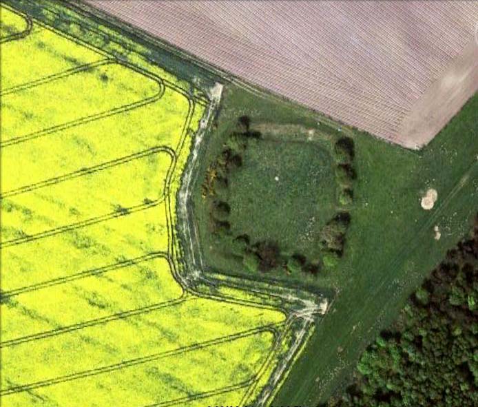
Thought to have been first constructed in the late Bronze Age period, in 1963 R.H. Hayes described this site as being “the finest enclosure type of earthwork in the district,” telling:
“It is roughly quadrangular, some 54 yards across, rampart to rampart, with internal ditch 12ft wide and in places still 4ft in depth. The rampart is 24-26ft wide and 9-10ft high above the bottom of the ditch. It is of earth and rubble with an entrance 9ft wide on the ESE. One gets the impression that the central area is a araised platform above the level of the surrounding moor.”
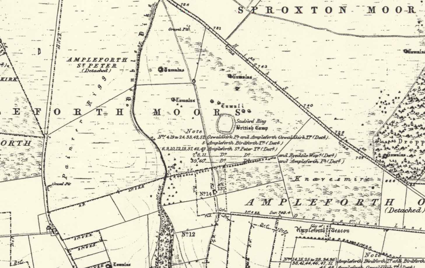
Studfold Ring on 1856 OS-map
At the time of Hayes’ description, conclusions about the purpose of this site were difficult. He drew parallels between this and two other sites in northeast Yorkshire: one on Great Ayton Moor and another near Borrowby on Newton Mulgrave Moor.
On the outside of the ‘enclosure’ he described “a curious turf (?) bank 6ft wide and 2ft high which curves around the tumuli to the northeast, following the ditch of one of them, thence to another mound 32ft in diameter north of the Ring, whence it turns due west and runs towards a dewpond in the junction of three turf walls,” finally adding, “It could be connected with ancient cultivation.”
According to Eilert Ekwall (1922), the name Studfold probably derives from,
“‘Stodfalod’, which is a common name for old Roman (or other) enclosures. The name indicates that the Anglo-Saxons often used such old enclosures for horsefolds.”
Place-name master A.H. Smith (1956) reinforces this and tells us the dates of this name are even later; describing,
“stod-fald OE, ‘a stud-fold, a horse enclosure’; the word is often applied to ancient enclosures which the Anglo-Saxons used for horse-folds.”
Modern archaeo’s have added the etymologist’s notion of a ‘horse enclosure’ onto their summaries of the site in recent years.
…to be continued…
References:
Ekwall, Eilert, The Place-Names of Lancashire, Manchester University Press 1922.
Hayes, R.H. ‘Archaeology: Dikes and Earthworks,’ in J. McDonnell’s A History of Helmsley, Rievaulx and District, Stonegate Press: York 1963.
Smith, A.H. English Place-Name Elements, II, Cambridge University Press 1956.
White, Stanhope, The North York Moors: An Introduction, Dalesman: Clapham 1979.
Acknowledgements: Huge thanks to Martin Dawes for correcting my initial erroneous route to the site.
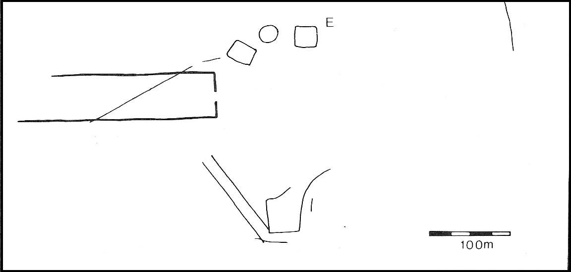
Sonning Cursus & other ancient remains (after Ford 1987)
Barely visible nowadays, the site was described by archaeologist Steve Ford (1987) as, “a very convincing cropmark with markedly rectangular end with entrance gap” at its far eastern end. This once impressive looking cursus aligns east-west and is found amidst a cluster of other neolithic and Bronze Age monuments.
It was first discovered by aerial surveying in 1959, but still remains unexcavated (I think!). The dead straight neolithic monument,
“consists of parallel ditches 45 metres apart extending for at least 200m west towards lower ground. The eastern end has a (flattened) terminal with a single entrance, whereas the western end is untraceable beyond a modern field boundary.”
In Roy Loveday’s (2006) survey, this cursus was stated as measuring 250m in length and 35m across. Although the western end hasn’t been located, it’s highly probable that it reached to the River Thames a short distance away. An excavation at one of the three ‘enclosures’ beyond the eastern end of this monument, revealed it have been built in the late neolithic period.
References:
Ford, Steve, East Berkshire Archaeological Survey, Berkshire County Council 1987.
Loveday, Roy, Inscribed across the Landscape, Tempus: Stroud 2006.
You can’t really miss this. Roughly halfway along the B1383 London Road between Littlebury and Wendens Ambo, just above Chestnut Avenue, a dirttrack on the west-side of the road takes you up and onto the wooded hillside. Where the track splits in two, head straightforward up and into the trees until it opens into the clearing. You’re there!
Archaeology & History
This great monument had already been described several times before the Domesday Book had even been thought about! Indeed, it seems that the town itself gets its name from the hillfort! (Reaney 1935) Nowadays the place is just about overgrown and covered in woodland. You cna make out various undulations where parts of the ditches are apparent, but it could do with a clean-out. Thought to be Iron Age, Nick Thomas (1977) described the site as,
“Oval in plan, this fort follows the contour of the hill it encloses, protecting about 16½ acres… the defences consist of a bank, ditch and counterscarp bank, of which only the ditch is well-preserved.”
References:
Reaney, Paul, The Place-Names of Essex, Cambridge University Press 1935.
Thomas, Nicholas, Guide to Prehistoric England, Batsford: London 1977.
Enclosure (destroyed): OS Grid Reference – TQ 675 811
Archaeology & History
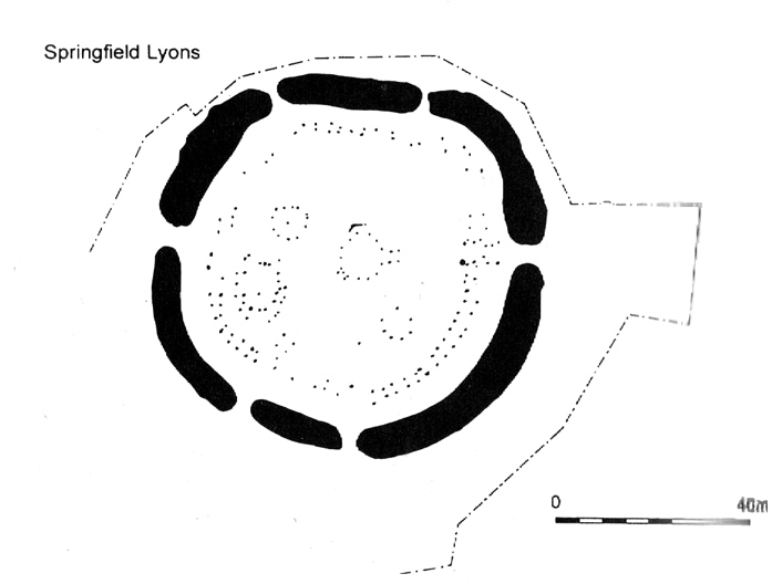
North Ring, Mucking (after Brown, 2001)
This large circular enclosure, measuring about 120 feet across, seemed to be a small settlement with several internal structures (fences, pits, cremations and a sunken-floored structure) that was first excavated in 1978 and described as a Bronze Age enclosure. Akin to a henge monument in some ways, this small settlement site had two entrances: one on the east and the other opposite on its west side. However, the main ‘entrance’ was on the eastern (sunrise) side, where post-holes laid a pathway over the ditch and into the structure itself.
The excavation on the eastern side of site revealed two periods of construction with associated structures, including three circular buildings. Some excavations to the east produced evidence for a range of contemporary activities. The assemblage of Late Bronze Age material included pottery, metalwork, cremation remains, sickle moulds and equipment for salt production. For further info and imagery, see the Link below.
References:
Bond, Dermot, Excavation at the North Ring, Mucking, Essex, East Anglian Archaeology 1988.
Brown, N., “The Late Bronze Age Enclosure at Springfield Lyons in its Landscape Context,” in Essex Archaeology & History, volume 32, 2001.
We’ve known that there was an excessive number of prehistoric archaeological sites in and around the Chelmsford region for quite a long time now, but defining precisely the age and nature of the finds takes some doing! (as you’d expect) It hasn’t helped, of course, with the housing estates and other ecologically destructive building operations in and around the area, screwing up a more accurate and patient assessment of the material there. And this predicament was exemplified with the Springfield Lyons neolithic causewayed enclosure just as much as at the Springfield Cursus and other sites nearby.
Although excavations here found a large, deep ditch with impressive ramparts and entrance, in Oswald, Dyer & Barber’s (2001) survey of these giant monuments, they defined the remains here as “probable,” pending further investigations. But the site was primarily defined by the large deep ditch, broken in several places round its edges with the ’causeways’ built leading onto the site. The enclosure gave good views over the small valley from here and had streams running either side of it.
Adjacent to the site were the remains of a “small circular enclosure with multiple entrances,” saying that excavation here,
“has proved that it is of late Bronze Age date and might be interepreted variously as a defended settlement, or a ritual monument.”
This external small enclosure site was then conjectured, quite spuriously it’s gotta be said, to be a mini-version of the great causewayed enclosure monument, saying:
“Its siting and form both hint that it could have been a conscious imitation of, or re-invention of, the perceived form of the earthworks of the neolithic enclosure.”
I like the idea, it’s gotta be said — but without direct evidence we’ve gotta take this idea with a large pinch of salt!
…to be continued…
References:
Brown, N., ‘The Archaeology of Essex 1500 – 500 BC,’ in Bedwin, O. (ed.), The Archaeology of Essex, ECC: Chelmsford 1996.
Brown, N., “The Late Bronze Age Enclosure at Springfield Lyons in its Landscape Context,” in Essex Archaeology & History, volume 32, 2001.
Oswald, Alastair, Dyer, Caroline & Barber, Martyn, The Creation of Monuments: Neolithic Causewayed Enclosures in the British Isles, EH: Swindon 2001.
Priddy, D., ‘Excavations in Essex, 1987,’ in Essex Archaeology & History, 19, 1988.
Attributed by Michael Dames (1996) and others before him as the abode of the Dagda and the house of the sun, this huge monument was recorded in the Irish Annals as being destroyed in 1101 AD following a great battle. A site of mythic importance to the very early Irish Kings and Queens, and used by the shamans of the tribes, The Grianan is a place of of legendary importance to folklorists, historians and archaeologists alike and has been widely described over the last 150 years. Although the site you see today was hugely reconstructed between the years 1874 and 1878, it’s still impressive and, wrote George Petrie (1840), commands,
“one of the most extensive and beautifully varied panoramic prospects to be found in Ireland”!
Used over very long periods of time, the archaeologist Brian Lacy (1983) described the Grianan, on the whole, as,
“a restored ‘cashel’*, centrally placed within a series of three enclosing earthen banks; the site of an approaching ‘ancient road’; and a holy well.”
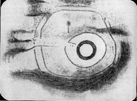
Early ground-plan of the Grianon
Lacy’s description in the Donegal Inventory is considerable and culls from the various surveys and reports done in the past. First surveyed by George Petrie in 1835, the internal body of the stone-built site is roughly circular and measures around 25 yards across, with a singular entrance on its eastern (sunrise) side. A stone ‘seat’ is at the end of the internal passage. At the centre of the huge ‘room’, Petrie recorded traces of a rectangular stone structure that he thought might have been the remnants of some old chapel built sometime in the 18th century.
More than 25 yards outside of the primary stone building is another surrounding embankment, oval in shape, low to the ground and with another singular entrance to the east — though this entrance is not in line with that of the main structure. At a further distance out from this embankment are the remains of another two oval ‘enclosures’, though the the remains of the outermost one is considerably more fragmented.
Although the replenished ‘fort’ dates from the Iron Age, early remains here are thought to have been of Bronze Age origin. A ‘tumulus’, now gone, being one such find here.
Folklore
There is much legend here. The creation myth narrated by Scott (1938) tells that it was,
“built originally by the Daghda, the celebrated king of the Tuatha de Danann, who planned and fought the battle of the second or northern Magh Tuireadh against the Formorians. The fort was erected around the grave of his son Aeah (or Hugh) who had been killed through jealousy by Corgenn, a Connacht chieftain.”
From similar legendary sources, it is told that,
“the time to which the first building of Aileach may be referred, according to the chronology of the Four Masters, would be about seventeen hundred years before the christian era. There are strong grounds for believing that the Grianan as a ‘royal’ seat was known to Ptolemy, the Greek geographer, who wrote in AD 120. In his map of Ireland he marks a place, Regia…which corresponds fairly well with its situation.”
By the outer banking on the south-side of the fortress is the remains of a much-denuded spring of water, the old water supply for this place. It gained the reputation of being a holy well, dedicated to St. Patrick.
References:
Dames, Michael, Mythic Ireland, Thames & Hudson: London 1996.
Harbison, Peter, Guide to the National Monuments in the Republic of Ireland, Gill & MacMillan: Dublin 1982.
Lacy, Brian, Archaeological Survey of County Donegal, DCC: Lifford 1983.
Petrie, George, ‘The Castle of Donegal,’ in Irish Penny Journal, 1, 1840.
Scott, Samuel, ‘Grianan of Aileach,’ in H.P. Swan’s Book of Inishowen, Buncrana 1938.
Swan, Harry Percival, The Book of Inishowen, William Doherty: Buncrana 1938.
Taking the A629 road between Shepley and Ingbirchworth, as you hit the staggered crossroads at High Flatts, take the west turn up the slightly sloping straight road of Windmill Lane. Just where the road ‘kinks’ at a small bend, stop and look into the field on your left.
Archaeology & History
Deemed by some as a hillfort, and others as settlement remains, what little are left of the remaining earthworks here were first described by local historian Henry Morehouse in 1861. Found about a mile west of Upper Denby, the site was described in the Victoria County History as being “on a commanding though not exactly a defensive situation on the slope of a hill.” This remark coming from the belief (and that’s all it is) that this was an Iron Age castle site. In 1924 James Petch said of it,
“The earthwork seems originally to have been almost square, and two sides and an angle remain. The external ditch is from ten to twelve feet broad in its present state.”
While Faull & Moorhouse (1981) tell of there being “evidence for Neolithic activity” here, modern surveyors reckon it as an old prehistoric settlement — which makes sense; though little of the site remains to be seen today.
References:
Faull, M.L. & Moorhouse, S.A., West Yorkshire: An Archaeological Survey, I, WYMCC: Wakefield 1981.
Morehouse, Henry James, History and Antiquities of the Parish of Kirkburton and the Graveship of Holme, Roebuck: Huddersfield 1861.
Petch, James A., Early Man in the District of Huddersfield, Huddersfield 1924.
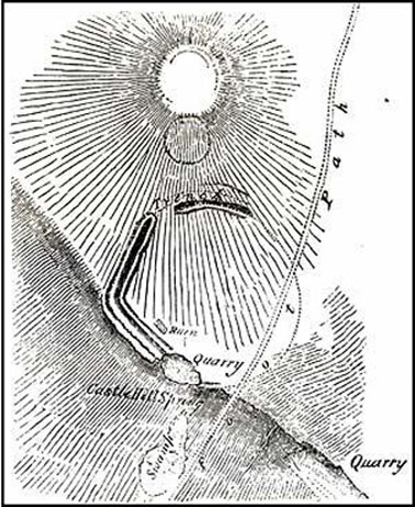
A 2½-mile long earthwork can obviously be reached from all sorts of ways, but coming out of Flamborough towards Bridlington (B1255 road) you can go down the Home Farm road and park up; and from here walk up the pleasant woodland walk, literally from coast to coast, where you’ll see good portions of the earthwork intact.
Archaeology & History
An impressive site by any means. Running from Dykes End on its southern edge for 2½ mile, roughly north, until hitting the North Sea again at the other Dykes End, this great earthwork had little to do with the Danes. It seems to have been originally started around 3000 years ago in the early Iron Age. As Mr Gower (1975) told:
“Excavations carried out at the end of the (19th) century revealed traces of a flint workshop and many arroheads were found… The earthwork is about 18 feet high and on the western side is a ditch 60 feet wide. Several openings are to be seen, but these are probably comparatively recent.”
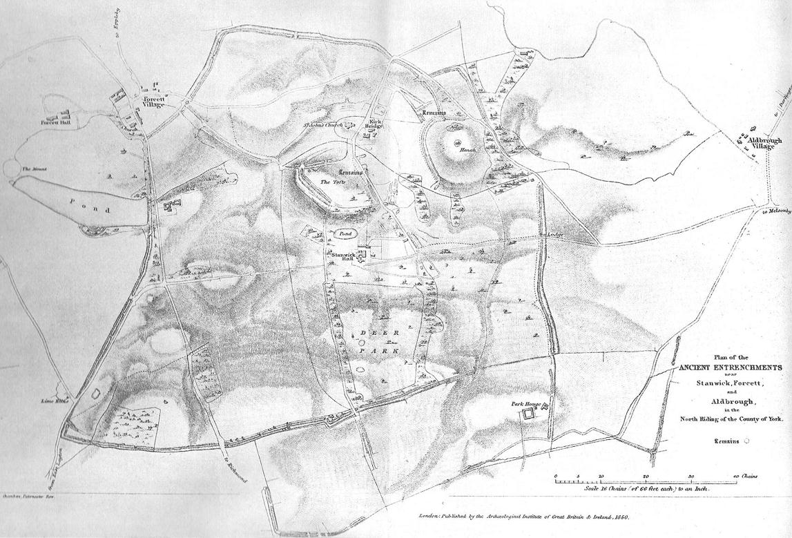
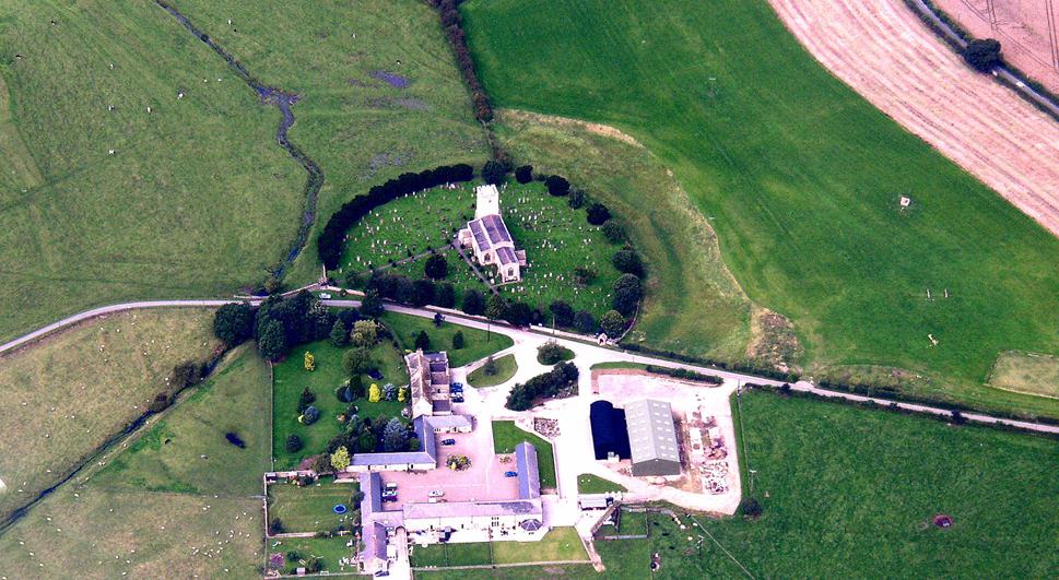
From Scotch Corner on the A1, head on the A66 and take the first right up to and straight thru Melsonby village at the crossroads and on for a few more miles till you hit the hamlet of Stanwick-St.-John. You’re now in the middle of the fortifications and earthworks! (check the map, right) Get to the nearby church of St. John’s and you’re on what once could have been a henge.
Archaeology & History
Although the Roman’s came here, the origins of this huge enclosure and settlement — between the hamlets of Eppleby and Stanwick St. John — are at least Iron Age. It’s very probable that this place has been used by people since at least the Bronze Age, if not earlier — but let’s keep to playing safe (for a change) and repeat what the professionals have found! Stanwick was recorded in Domesday as Stenwege and Steinwege, which A.H. Smith (1928) and later etymologists tell us means “stone walls,” which obviously relates “to some ancient rock entrenchments found in the township”, or the Stanwick Fortifications no less!
Sir Mortimer Wheeler’s (1954) account of the history and excavation of these huge ramparts found that it was a centre of some importance to the Brigantians. His view was that it was the rebel stronghold of the Brigantian figure called Venutius, ex-partner of the Queen Cartimandua. Archaeologists who did further work here in the 1980s concluded that it was one of Cartimandua’s “estates” — possibly even the original capital city of Brigantia.
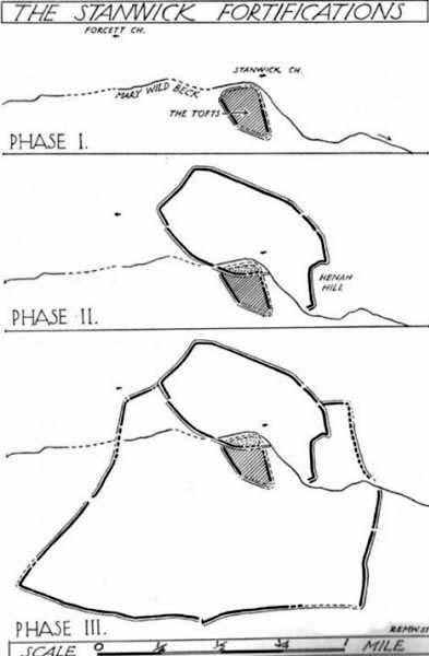
The settlement was enlarged and fortified considerably upon the arrival of the Romans in the first century. Splitting them into three phases, the earliest Phase I area (Iron Age) covered 17-acres; Phase II was extended over 130 acres; and Phase 3 extended the enclosure over another 600 acres. A further extension of earthworks appears to have occurred, but Wheeler believed them to have been constructed at a much later period. To allow for a decent discourse on this huge site and its multiperiod settlement, I’m gonna quote extensively Mr Wheeler’s (1954) text on the site, who headed a team of archaeologists in the summers of 1951 and 1952 and explored various sections of this huge arena.
In the introduction to his work, Mortimer briefly mentioned the finding of some chariot burials found close by, though less certain is the exact spot where these important remains came from. He wrote:
“Of the three accounts, the earliest, dating from shortly after the discovery, states that the objects ‘were deposited together in a pit at a depth of about five feet within the entrenchment at Stanwick. Near by large iron hoops were found.’ Two years later MacLauchlan showed the find-spot on his map…as a little to the northeast of Lower Langdale, well outside the main Stanwick earthworks, and, in spite of variant accounts, his evidence may be regarded as authoritative.”
Nothing more is said of these finds throughout the book. Instead, Mortimer guides us through their dig, beginning with the structural sequence of the extensive earthworks that constitute Stanwick’s fortifications, from Phase 1 onwards, saying:
Plan showing 3-phase evolution of Stanwick earthworks from the Iron Age period at the top, to Phase 3 works in the 1st century AD (from Wheeler’s ‘Stanwick Fortifications’, 1954)
“Phase I. The nucleus of the whole system is a fortified enclosure, some 17 acres in extent, situated to the south of Stanwick Church and the Mary Wild beck, on and around a low hill known as ‘The Tofts’… The name ‘Tofts’ is defined by the Oxford Dictionary as “Site of a homestead”, or “An eminence, knoll or hillock in a flat region; esp. one suitable for the site of a house.” Appropriately the field is described by the farmer as a ‘dirty’ one; it produces an abundant crop of nettles which have to be cut twice a year and are a common sequel to ancient occupation. The enclosure is, or rather was, roughly triangular on plan, conforming approximately with the mild contours of the hill and to that extent meriting the exaggerated designation of ‘hill-fort.’ On the west its rampart and ditch are excellently preserved in a stretch of plantation known as ‘The Terrace’ or ‘The Duchess’s Walk’, where the single bank of unrevetted earthwork rises some 24ft above the ditch… The southern corner has been almost completely obliterated, but a part of it can be traced faintly in the walled garden southeast of the The Terrace. A stretch of the eastern side still stands up boldly beside the road from Stanwick Church to (the former) Stanwick Hall, but a large part of this side has been demolished for the making of the road, and some dumps of earth immediately east of Church Lodge may be a result of this process. The northern side approached but stopped short of the brook, and is marked by remains of a counterscarp bank… The main rampart was here thrown into the ditch anciently, doubtless when this portion of the work was included in and superseded by the work of Phase II. Near the northwestern corner was a stone-flanked entrance, now partially obscured by the northern end-wall of the Terrace plantation. The rampart was of earth, apparently without stone or timber revetment, the ditch was V-shaped save where, on the northern or lowest side, its completion in depth was stopped by water and the counterscarp bank already referred to was added as compensation.
“Phase II. Subsequently, at a moment which will be defined in the sequel as not later than AD 60, the hill-fort was supplemented by a new enclosure over 130 acres in extent, so designed as to outline the slight ridge north of the brook, to bend inward round the nearer foot of Henah Hill on the east, and farther west to cut off the northern end of the hill-fort, obviously in order to enclose the brook and its margin hereabouts. Southeast of Stanwick Church, the marshy course of the brook for a distance of over 300 yards was regarded as a sufficient obstacle, without rampart and ditch, though whether supplemented by a palisade is not known. As already indicated, that part of the Phase I earthwork which now lay inside the new enclosure was largely obliterated by filling its rampart into its ditch.
The enclosure constituting Phase II had an entrance near its western corner…where 50ft of the ditch, partially rock-cut, were cleared with notable results… There may have been another entrance under the present road-junction immediately east of the Stanwick vicarage, in the middle of the northern side, or less probably, at an existing gap 150 yards further to the southeast. The rampart was of earth, aligned initially at the back on a small marking-out trench and bank; in front it was revetted with a vertical drystone wall. The ditch was cut in the boulder-clay and partially in the underlying limestone…
Phase III. At a date which will be defined as about a dozen years later (c. AD 72), a similar though longer system, enclosing a further 600 acres, was added to Phase II. It impinges almost at a right angle upon, and implies the pre-existence of, Phase II on the east, and terminates upon the ditch of Phase II on the west. An entrance can be seen near the middle of the southern side, and less certainly a gap in Forcett Park may represent a second entrance in the western side. Further stretches of the mary Wild beck were included. The rampart, like that of Site A, incorporated a marking-out trench and bank at the rear, and was fronted with a vertical stone revetment.
Phase IV. To the southern side of Phase III was added at an unknown period an enclosure of some 100 acres, now subdivided by traces of a double earthwork extending southwards from a point east of the southern entrance of Phase III… This double earthwork however, is of an entirely different character from those already considered, and appears indeed to overlap the rampart of Phase III at a point where the latter had already been broken through. It is comparable with some of the double banks which constitute or are incorporated in the Scots Dike at Lower Langdale, farther east; and the Phase IV enclosure is in fact linked with the Scots Dike by a semi-obliterated ditch extending eastwards from its southeastern corner. Phase IV…may, as has been suspected, relate to the Anglo-Saxon period.”
References:
Smith, A.H., The Place-Names of the North Riding of Yorkshire, Cambridge University Press 1928.
Wheeler, Mortimer, ‘The Stanwick Excavations, 1951,’ in Antiquaries Journal, January 1952.
– The Stanwick Fortifications, North Riding of Yorkshire, OUP & Society of Antiquaries: London 1954.
Links: – Stanwick Iron Age Hillfort – For an extensive overview of the archaeology of this large site, you can do no better than this web-page.
From Litton Cheney go north up the White Way road until it meets the main A35 crossroad. Go across the road, then get over the fence on your right and onto the rise in the hill. These earthworks, or timber circle remains, are under your feet!
Archaeology & History
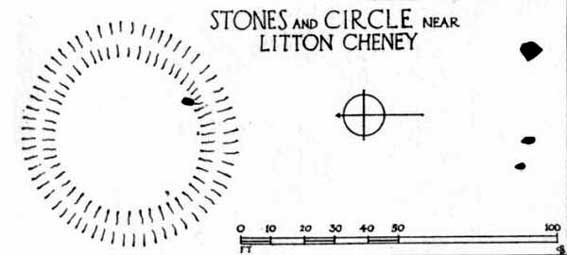
Lay-out of site by O.G.S. Crawford, 1939
Shown on modern OS-maps as an ‘earthwork’, but ascribed elsewhere as a timber circle, when Stuart & C.M. Piggott visited and surveyed this site in the 1930s, they thought it to be the remains of stone circle. Found on a prominent rise in the landscape with excellent views all round here, the Piggott’s description of the site told:
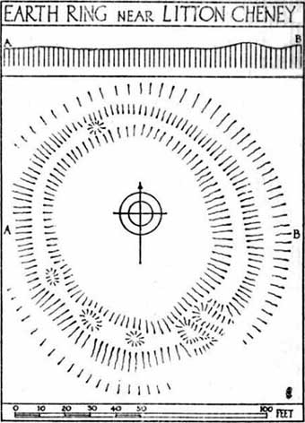
“It consists of a shallow ditch with internal bank, enclosing a somewhat oval area measuring 75 feet from north to south, and 63 feet from east to west. The ditch, which lies on the southeast, where the ground has been disturbed, does not reach a depth of more than about one foot, while the bank rises nowhere above 2.5 feet. It is possible there was an entrance on the southeast, but the bank is disturbed at this point. On the crest of the bank on the southwest are 3 almost circular depressions, some 6 feet in diameter, and placed 20 feet distant from one another along the circumference of the bank. Another similar depression is on the northeast, while yet another may have existed in the disturbed portion of the bank on the southeast.”
It was these finds which led them to suppose a ring of stones originally surmounted this small hillock, twelve in all.
Ground-plan by O.G.S. Crawford
Another site — which they called ‘Litton Cheney 2’ — was found less than 50 yards to the east of here by a Mr W.E.V. Young and the Piggotts. These remains comprised of, “a very shallow and regular ditch surrounding a circular area 47 feet in diameter. A single sarsen lies on the inner lip of the ditch on the southeast” which, they thought, may have been the solitary remains of yet another stone circle. Three other sarsen stones were found 90 feet south of here, but they were unsure whether they related to the circle or not.
Archaeological remains from here dated from 2200-1400 BC and local researcher Peter Knight (1996) thought that the sites ascribed here as megalithic rings to be correct. He also found that tumuli visible some 5 or 6 miles southeast of here, on top of Black Down Hill (where the Hardy Monument’s found), “marks out the winter solstice sunrise.” A dip in the horizon to the northwest, he claims, also marks the summer solstice sunset from here. Knight also mentions how “both Litton Cheney sites lie close to a ley line going to the Nine Stone Circle and beyond.”
References:
Knight, Peter, Ancient Stones of Dorset, Power: Ferndown 1996.
Piggott, Stuart & C.M., ‘Stone and Earth Circles in Dorset,’ in Antiquity, June 1939.