Tumulus (destroyed): OS Grid Reference – TA 4160 1748
Archaeology & History
In and around East Yorkshire, the fabled Yorkshire antiquarians William Greenwell and J.R. Mortimer uncovered and excavated many now-lost prehistoric tombs—some of which, beneath the rounded tumulus of earth, were constructed out of wood instead of stone. A little-known site, now long gone, once existed in what is now the North Sea, just a few hundred yards off the Easington coast. Other sites close by are soon to be completely swallowed back into Earth’s body, right on the water-line, but the site described here has long gone. What little was known of it was described in Mortimer’s (1905) magnum opus, where he told:
“On the beach at Easington, in Holderness, under a tide-demolished barrow, Dr Hewetson and the writer on April 21st, 1894, discovered a double cist made of broad slabs split from the outer shell of the decayed trunk of a willow tree. This barrow had been swept away by the waves, and its site was at about half-tide-line, and a considerable way from the very low cliffs. Lining the grave with wood (the branches of trees) would not be difficult to accomplish and would be practised as a protection to the body.”
A henge monument and several other prehistoric barrows have been located in and around Easington, but they’re fading fast!
References:
Mortimer, J.R., Forty Years Researches in British and Saxon Burial Mounds of East Yorkshire, A. Brown: London n.d. (1905).
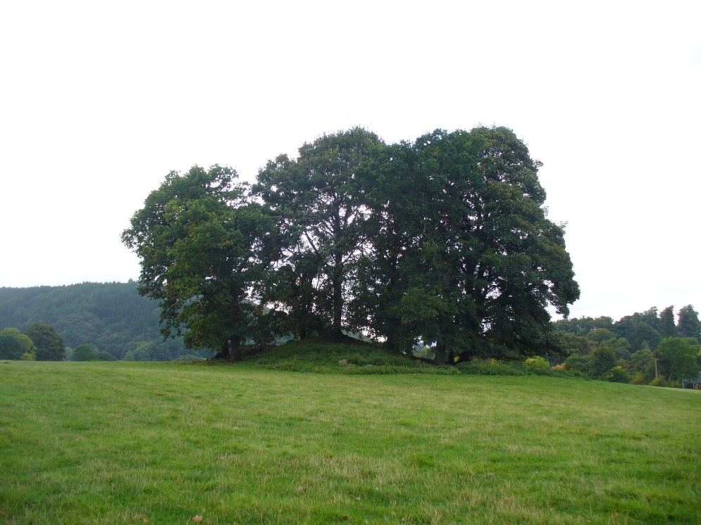
If you’re coming southwest out of Crieff on the A822, as you cross the river take the right-turn just before leaving the town along the country lane onto Strowan and Dalginross. Nearly 2½ miles along there’s the small junction on your right to Strowan House and church. Just past this turning, the next field on by the roadside, has a large rounded tree-covered mound living quietly. That’s the fella!
Archaeology & Folklore
Found halfway between Crieff and Comrie in the field on the north-side of the road, this large oak-covered tumulus was, seemingly, first described in notes made by the old archaeologist O.G.S. Crawford following a quick visit he made here in 1936. The place has, since then, never been excavated to find out exactly what might be hiding therein! It’s quite a big fella too: about 10 feet high and 40 yards across (east-west)—similar in size and design to the prehistoric burial mounds at Tulloch and Kinpurnie. Some large rocks make up the sides and edges of the mound, with smaller ones scattered here and there, giving the distinct impression of a very overgrown cairn of sorts.
Tis a quiet and tranquil arena, amidst fervent colours of meadows and old trees. Another 2 miles further down the same road is the equally tranquil (though ruined) megalithic ring of Dunmoid…
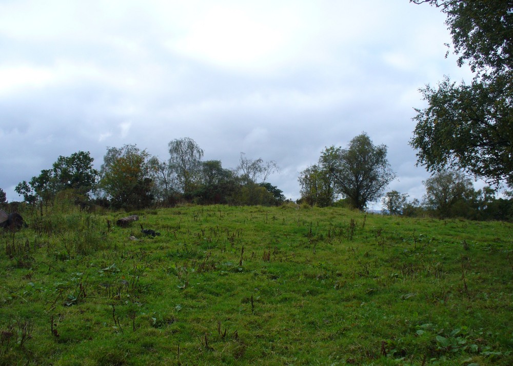
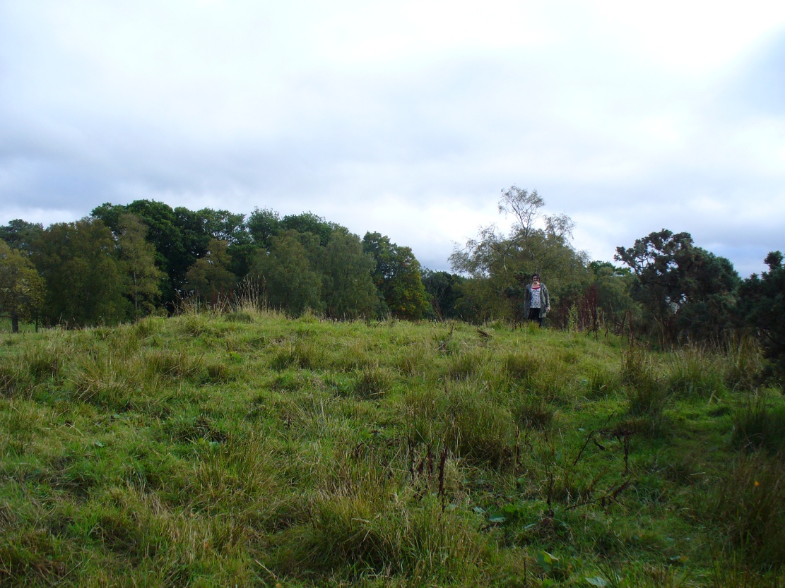
From Bridge of Allan go down the main A9 road towards the University, but turn left up the Sheriffmuir road, 100 yards up turning right to keep you on track up the steep narrow dark lane, turning left at the next split in the road. Follow this for a mile or two all the way to the very end where the tell-tale signs of the unwelcoming english incomers of ‘Private’ now adorns the Pendreich farm buildings. There’s a dirt-track veering uphill diagonally right from here. Go up here and as it bends slightly left, look into the open copse of trees to the highest point here less than 100 yards to you right. That’s it!
Archaeology & History
Lisa gives an idea of scale
The remains of this prehistoric tomb sits right on the very crown of the hill round the back of Pendreich, covered on its western edges by old gorse bushes. Its eye speaks with the nearby sites of the Fairy Knowe to the south, the fallen standing stone of Pendreich Muir to the northeast, the associated cairns to the east, and the Pictish fortress of Dumyat behind them. When I came up here for the first time last week with local archaeologist Lisa Samson, we found that the land upon which the cairn now lives is fertile with a variety of edible (Boletus, Amanita, etc) and sacred mushrooms (Panaeolina, Psilocybes, etc). And, despite being told by locals and the archaeology record as a place where very little can be seen, I have to beg to differ.
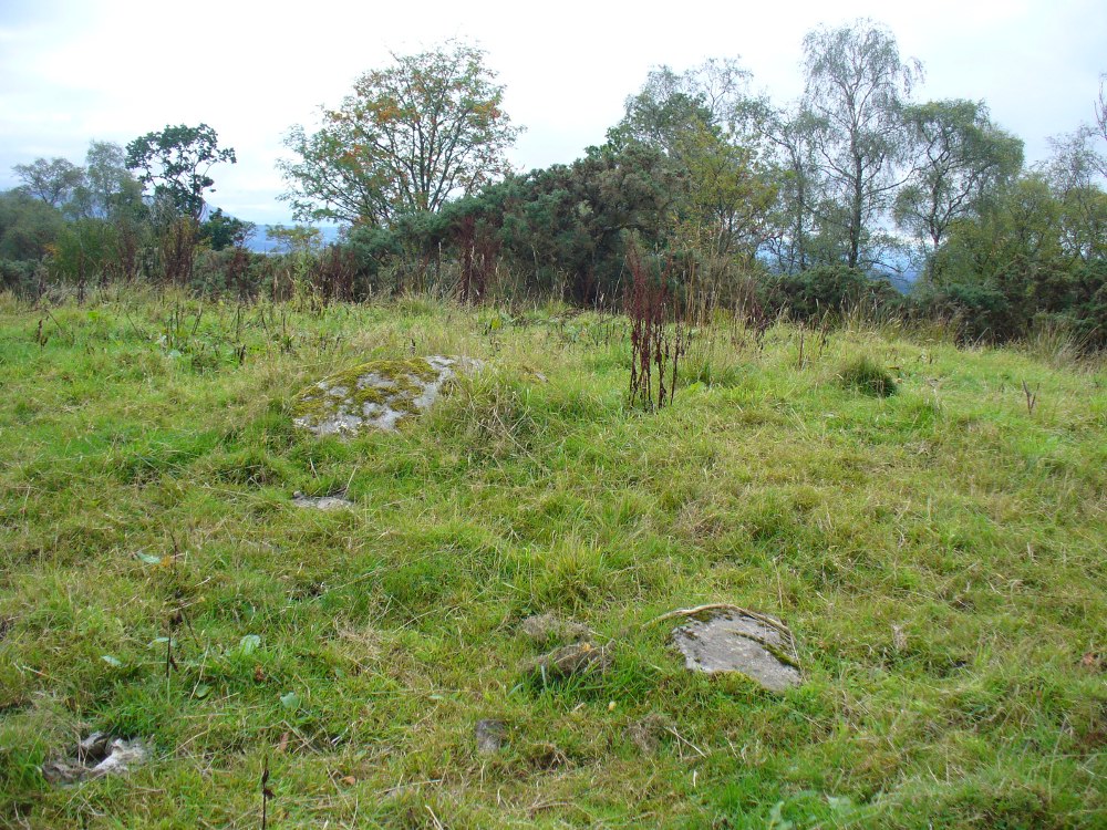
Fallen stone at the cairn edge
The crowning cairn is of course much overgrown and has been dug into in earlier years, but just beneath the grassy surface you can feel and see much of the stone that constitutes this buried site. The cairn itself rises a couple of feet beneath the grass and is clearly visible as you walk towards it. At its edges there seems to be the fallen remains of a surrounding ring of stones. Inside of this ring we can see and feel the overgrown rocky mass and open cists sleeping quietly, awaiting a more modern analysis to tell us of its ancient past. When the site was visited by the Royal Commission lads in the 1960s, they went on to tell us the following about the place:
“This cairn is situated on the summit of a low knoll within a felled wood, 170 yards ENE of Pendreich farmhouse at a height of 600ft OD. It consists of a low, grass-covered mound which measures 40ft in diameter and stands to a maximum height of 1ft 6in. The surface is disfigured by pits caused in 1926 when the cairn was opened and three cists were uncovered. Two of these contained no relics; in the third there were fragments of bones and a broken beaker, some sherds of which are preserved in the Smith Institute, Stirling.”
Although we find the scattered remains of old farm equipment lying round the edge of this tomb, it’s still a good site to visit and, I’d say, worthy of further archaeological attention.
References:
Royal Commission on the Ancient & Historical Monuments Scotland, Stirling – 2 volumes, HMSO: Edinburgh 1963.
Royal Commission on the Ancient & Historical Monuments of Scotland, Archaeological Sites and Monuments of Stirling District, Central Region, Society of Antiquaries of Scotland 1979.
Watson, Angus, The Ochils – Placenames, History, Tradition, Perth & Kinross District Libraries 1995.
Plan of Rudston D Cursus & associated monuments (after I.M. Stead 1976)
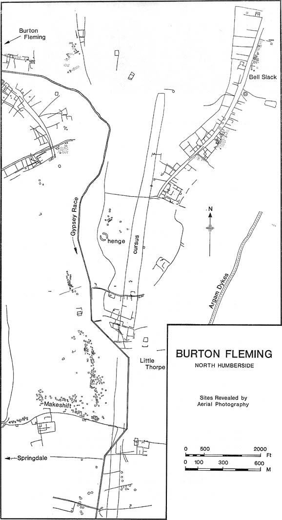
To the north of Rudston village and its giant standing stone, running roughly parallel with the divinatory waters of the Gypsey Race river and passing a mass of prehistoric remains en route, we find one the biggest prehistoric cursus monuments in the British Isles: the Rudston D cursus. More than twice as long as any of the three other cursus monuments nearby, its northern end or ‘terminal’ is flattened in nature (others are rounded) and is due east of the village of Burton Fleming starting at the intriguingly-named Maidens Grave field, just as the land begins to rise at TA 099 717. From here it begins its almost southern trajectory and runs almost dead straight for several hundred yards until edging, ever so slightly in direction, to a slightly more secure southern alignment. Past the site of the Rudston henge, the cursus broadens out slightly and, as it reaches the farmlands of Littlethorpe, edges slightly further to a more decisive direct southern route. The cursus then maintains a dead straight course for another mile, heading straight for, and stopping just short of the Rudston monolith in its modern churchyard. A short distance before we reach its southern end, archaeologists found that a section of the Cursus C monument cut right across it. Altogether, the Rudston D Cursus is more than 4km (2.3 miles) long! At its narrowest width, this monument is a mere 160 feet (50m) across, and at its widest is 280 feet (90m). A giant by anyone’s standard!
Along the entire length of this continuous ditch and inner bank there were just 3 small cuttings on the western side and three on the east, but two of the eastern openings were quite large. Some of these openings were affected by natural elements and others by modern agriculture. Today, much of this gigantic ritual monument (as the archaeologists call them) is not visible at ground level.
In visiting this area, make yourself aware of the other monuments in this class: the Rudston A cursus and Rudston B cursus, southeast and southwest of here respectively. A full multidisciplinary analysis of the antiquities in this region is long overdue. To our ancestors, the mythic terrain and emergent monuments hereby related to each other symbiotically, as both primary aspects (natural) and epiphenomena (man-made) of terra mater: a phenomenon long known to comparative religious students and anthropologists exploring the animistic natural relationship of landscape, tribal groups and monuments.
References:
Burl, Aubrey, Rites of the Gods, J.M. Dent: London 1981.
Harding, Jan, ‘Pathways to New Realms: Cursus Monuments and Symbolic Territories,’ in Barclay & Harding, Pathways and Ceremonies: The Cursus Monuments of Britain and Ireland, Oxbow: Oxford 1999.
Loveday, Roy, Inscribed Across the Landscape: The Cursus Enigma, Tempus: Stroud 2006.
Pennick, Nigel & Devereux, Paul, Lines on the Landscape, Hale: London 1989.
Stead, I.M., ‘La Tene Burials between Burton Fleming and Rudston,’ in Antiquaries Journal, volume LVI Part II, 1976.
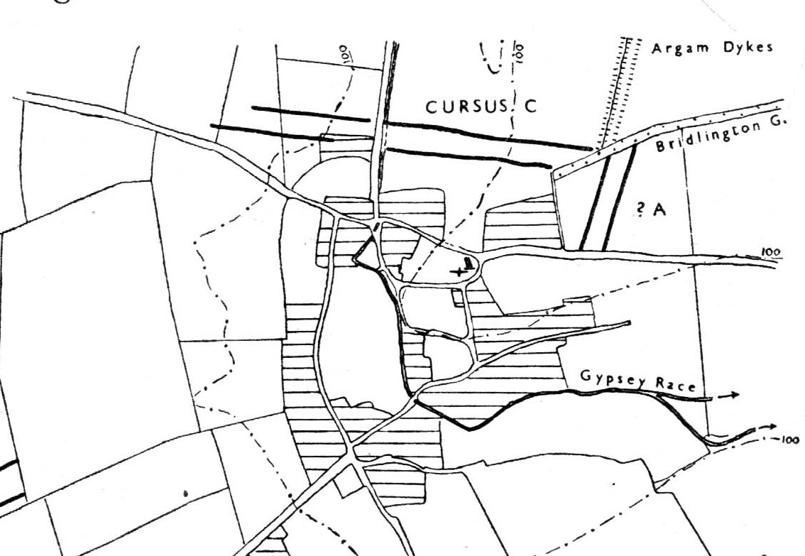
Of the four giant linear cursus monuments that were laid out around the landscape that holds Britain’s largest standing stone—the Rudston monolith—this one, the Rudston ‘C’ cursus, is the one we know the least about. This is mainly due to it receiving the minimum of archaeological attention, which can be forgiven round here as there is so much material to explore! Traces of the cursus at ground level are also quite negligible. Thankfully however, like the other cursus monuments nearby, some of the site can be made out on GoogleEarth.
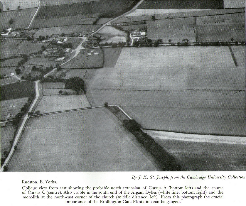
The alignment of this cursus runs east-to-west, cutting across the Cursus D monument and then running above the northern course of Nature’s curious river known as the Gypsey Race, which local folklore ascribes as being used in animistic divinatory practices. Cursus C was first noticed in aerial photographs taken by Prof. J.K. St. Joseph in 1961 and first described by D.P. Dymond (1966) a few years later, who told us:
“Immediately north of the village (Rudston), two parallel ditches, about 60 yards apart, are visible as crop-marks running east-west for 1000 yards… As they are too far apart to be considered as road-ditches and are similar to the linear ditches (of Rudston A and B), they are best interpreted as a fragment of a third cursus, C. The western end fades out near the York road as it climbs onto high ground, while at the east the ditches disappear into Bridlington Gate Plantation. Like Cursus A, this also crossed the Gypsey Race. Approximately 1½ miles northwest of the last westward point of these ditches is the presumed site of two lost long barrows, joined together at one end. There may, therefore, have been an original connection between Cursus C and these long barrows.”
First faint photo of Cursus C
His final remark is quite a good one! And since Dymond’s initial description (according to the PastScape lads anyhow), Cursus C has been found to be much longer than the initial 1000 yards, growing another 500 yards at least! The final point or ‘terminal’ on the eastern end still remains hidden, as it was intruded upon by the later Argham Dyke and the trees. The start or western terminal also remains unfound, so we don’t know for sure the exact length of this giant neolithic ‘line on the landscape’, as Pennick and Devereux (1989) call them.
References:
Dymond, D.P., “Ritual Monuments at Rudston, E. Yorkshire, England,” in Proceedings of the Prehistoric Society, volume 32, 1966.
Harding, Jan, ‘Pathways to New Realms: Cursus Monuments and Symbolic Territories,’ in Barclay & Harding, Pathways and Ceremonies: The Cursus Monuments of Britain and Ireland, Oxbow: Oxford 1999.
Loveday, Roy, Inscribed Across the Landscape: The Cursus Enigma, Tempus: Stroud 2006.
Manby, T.G., “The Neolithic in Eastern Yorkshire,” in Archaeology in Eastern Yorkshire, University of Sheffield 1988.
Pennick, Nigel & Devereux, Paul, Lines on the Landscape, Hale: London 1989.
Stead, I.M., ‘La Tene Burials between Burton Fleming and Rudston,’ in Antiquaries Journal, volume LVI Part II, 1976.
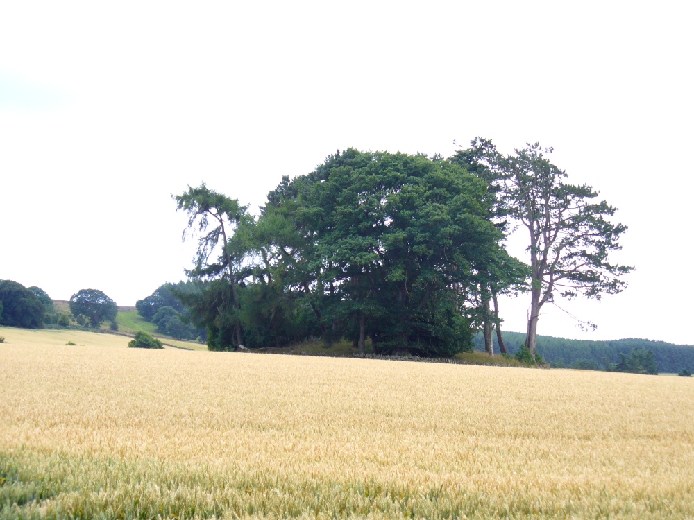
Head out of Doune village and take the A84 to Stirling. Just a few hundred yards along, over the old river bridge, take the first right along the B8032 (don’t head into Deanston). Barely 500 yards along on the left-hand side, between the farmhouse and a small group of houses, note the large tree-lined mound in the middle, just over the fence. It’s quite a big fella – you can’t really miss it.
Archaeology & History
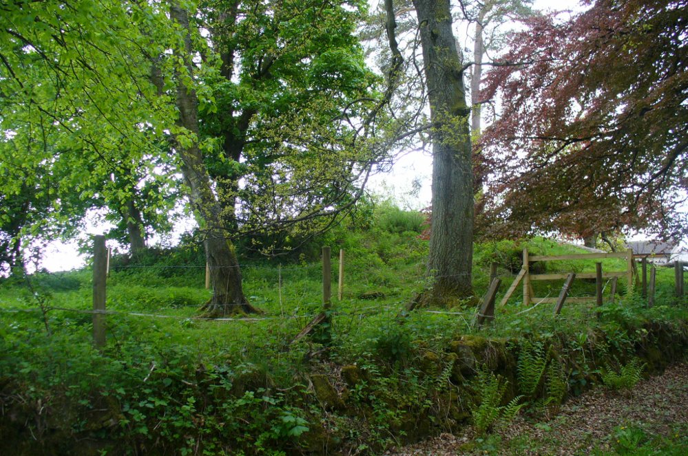
The mound and its trees
This is an almost archetypal fairy mound of a monument—and a mighty one at that!—living quietly in the field with its olde trees for company. Despite its size, it has brought little by way of archaeological attention and has, to my knowledge, never been excavated. Probably a Bronze Age burial mound, the tomb stands more than 15 feet high and is some 30 yards across east-west and 35 yards north-south. The Royal Commission (1979) listing of the mound says simply that “this large cairn measures 34m in diameter and up to 5m high.”
References:
Royal Commission on the Ancient & Historical Monuments of Scotland, Archaeological Sites and Monuments of Stirling District, Central Region, Society of Antiquaries of Scotland 1979.
A prehistoric tomb of unknown size was opened and robbed of its contents shortly before its total destruction sometime in the middle of the 19th century. There were no remains seen of the site when Ordnance Survey came here in 1854, and it is unlikely to have been confused with the large Thorn Knowe tumulus a half-mile to the northwest. A certain Prof. Duns (1876) described in an early article that the only remaining artefact from this tomb was an elaborate early Bronze Age spear-head, found in 1855, which he described at some length in the PSAS journal of the time. Neither he nor any other colleagues told us anything further about the tumulus.
Royal Commission on the Ancient & Historical Monuments, Scotland, Inventory of Monuments and Constructions in the Counties of Fife, Kinross and Clackmannan, HMSO: Edinburgh 1933.
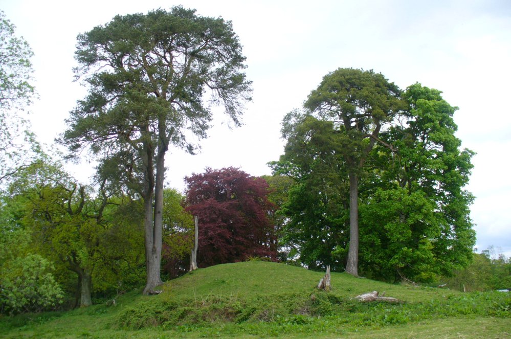
The best way to get here (when we went anyway, quite a few years back now), was via the old church . At the entrance to the church there was a signpost to the tumuli. Take the footpath to the left of the building and walk about 200 yards. Once you go under the railway bridge and into the trees, walk left and the overgrown mounds appear in front of you!
Archaeology & History
Thought to the largest Romano-British barrows in England, this was an incredible clump of giant burial mounds which, in more recent years, have been allowed to fall into neglect. Although a railway was built through this clump, it bypassed the main tumuli—and in doing so uncovered another cemetery! Four large barrows still remain and access, though alleged by some of those southern-types to be on private land, didn’t stop our foray here. The usual “private” signs showing just how unwelcoming some of them are, just made us Northerners more determined to find ’em! But that aside…
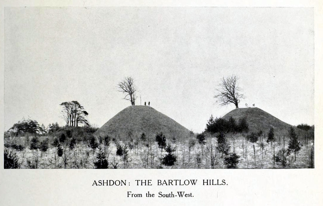
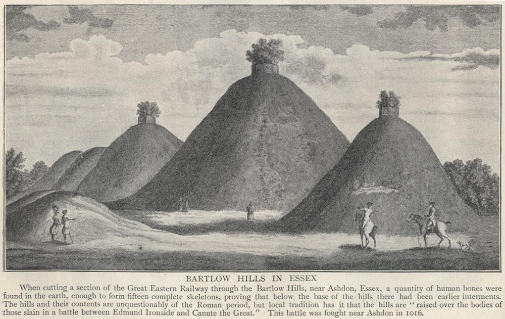
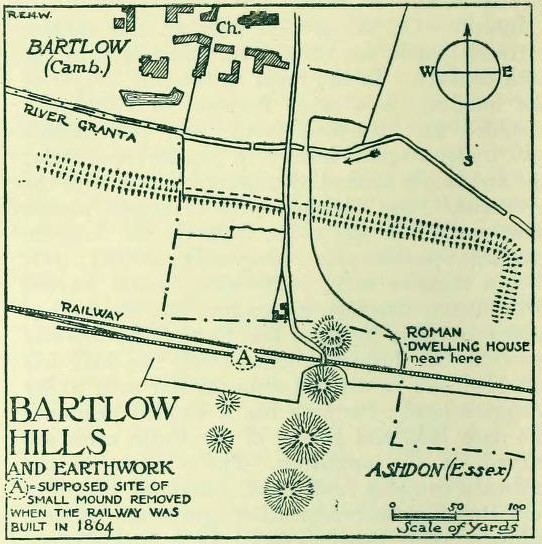
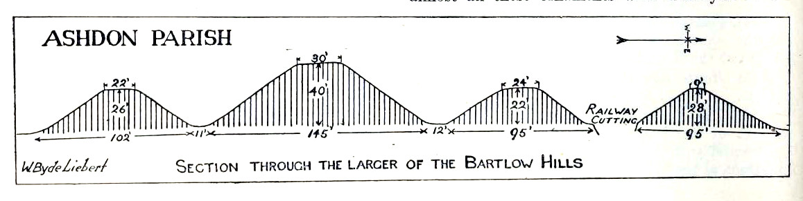
18th century drawing of the hills1916 map & plan
Although nowadays classed as being in Cambridgeshire, when the Royal Commission lads visited the site and described it in their Inventory (1916), the mounds were in the parish of Ashdon on the northern edge of Essex. But now it comes under the parish of Bartlow in Cambridgeshire—which seem sensible, as the word ‘bartlow’ itself stems from these very monuments. As the regional place-name expert P.H. Reaney (1943) told, Bartlow means,
“‘(At) the mounds of the birch trees,’ OE (æt) beorca-hlãwum, (from the verb) beorc, hlaw, i.e., the great Bartlow Hills tumuli which dominate the church and village.”
Described as early as 1232 CE as Berkelawe, these hills were opened in the middle of the 19th century and found to possess a mass of Roman remains. A number of articles in the journals of the period gave extensive descriptions of what was uncovered, but they are summed up nicely in the Essex Royal Commission (1916) report, which told:
“The principal monuments are the Bartlow Hills, which lie…at the extreme N.E. of the parish. They form (or formed) two parallel rows, running nearly N. and S. The eastern row consists of four large steep-sided mounds, in shape truncated cones, the largest 40 ft. high and 145 ft. in diameter; since 1760 three of the mounds have been planted with trees. The western row is now less clear: originally, it consisted of at least three small mounds, as was proved by digging in 1832; only two can now be faintly traced. Excavations, chiefly in 1832-40, have shown that all seven mounds contained at the centre regularly walled graves, within which was very costly grave-furniture of glass, decorated bronze, and enamel; almost all these ornaments were destroyed in a fire at Easton Lodge in 1847. The graves seem to belong to the end of the first and beginning of the second century and were doubtless built for Romanized British nobles of the district. The particular method of burial occurs especially in eastern England and in Belgium, and is native, not Roman, by origin.
“…Other burials have been noticed near the Hills — one with a flint axe and knife, presumably prehistoric. A small dwelling-house was found in 1852 about 100 yards E. of the Hills — mainly, if not wholly, within the Cambridgeshire border — but nothing of it is now visible on the surface.”
Section & sizes of the tumuli, 1916
The sites are very impressive indeed, though as we can see from the old images, when they were clear of trees they stood out much clearer.
Folklore
Old fairs used to be held at the Bartlow Hills, whose origin goes way back. There is also a curious custom which probably originated in some way from traditional beating of the bounds of the local township boundaries, narrated by folklorist Enid Porter. (1969) Throughout the region she reported how “skipping was performed on Good Friday”. It commenced at 10am and would continue into the evening. Porter wrote:
“An eighty year old woman of Linton recalled in the 1930s that in her youth the villagers of Linton and Hadstock used to skip on Good Friday to Bartlow Hills to join in the fun of the fair held there.”
An early legend uncovered from archives by Leslie Grinsell told that here could be found a “treasure chest said to have been concealed by Oliver Cromwell in the barrows known as the Three Hills, or in pits near them.”
…to be continued…
References:
Porter, Enid, Cambridgeshire Customs and Folklore, RKP: London 1969.
Reaney, P.H., The Place-Names of Cambridgeshire and the Isle of Ely, Cambridge University Press 1943.
Royal Commission on Historical Monuments, England, An Inventory into the Historical Monuments in Essex – volume 1, HMSO: London 1916.
From the large village of Newtyle, take the straight road west as if heading to Kettins. About half-a-mile along, 100 yards or so past the turn-off to Kinpurnie Castle on your left – stop! In the second field after the turn-off, halfway up the slope you’ll see a large circular rise in the land with a crown of large trees sitting thereon. That’s the cairn!
Archaeology & History
Not far from the impressive Keillor standing stone is this huge prehistoric tomb. Measuring about 90 feet across and more than 7 feet high in places, the mass of rocks making up the site is now crowned by a healthy ring of trees. Near the middle of it you can see a collapsed tomb or cist, but there may be more than one inside this giant fella. Its size implies that it was a tomb or burial centre for tribal elders, leaders or shamans. When we visited the site last week, the field was still in full crop, so we couldn’t take a close look at it and must return again at a later date. Apart from a brief note of the site in the Royal Commission (1983) archaeology listing for the county, no details have been made of this huge cairn—which is incredible in itself!
References:
Royal Commission on the Ancient and Historical Monuments of Scotland, The Archaeological Sites & Monuments of Central Angus, Angus District, Tayside Region, HMSO: Edinburgh 1983.
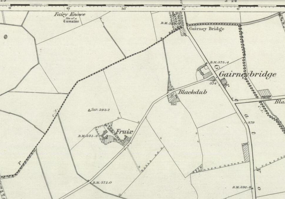
This is one of two sites in the county of Kinross-shire that were known as the ‘Fairy Knowe’, both of which have been destroyed through uncaring agriculture practices. Very little is known about it. The place was described in a lengthy footnote in the Old Statistical Account of Scotland (volume 6), which told us that,
Site shown on 1856 OS-map
“a tumulus or mound, composed mostly of earth, with some stones intermixed, on the east of Annofreuch, was opened a few years ago and a coffin found therein formed of rough flat stones, set on edge at the sides and ends, and a large one above; within which were some bones and many pieces of burnt wood interspersed. In the memory of some old people, it was called the Elf-hillock, but is now known by the name of the Fairyknow.”
The site was listed in the Royal Commission (1933) archaeological county survey, but with no further details.
Folklore
Although the site was a resort of the little people, or faerie-folk, we have no extant tales telling us anything more.
References:
Royal Commission on the Ancient & Historical Monuments, Scotland, Inventory of Monuments and Constructions in the Counties of Fife, Kinross and Clackmannan, HMSO: Edinburgh 1933.