Cairns (destroyed): OS Grid Reference – NS 780 926
Archaeology & History
In times past, there were at least two prehistoric tombs in land either side of old Birkhill House, now covered by the M9 motorway. The Scottish Royal Commission lads described the first as being “in the garden of Birkhill House,” continuing:
“This cist contained bones and an urn which measured 5in in height and 6in in diameter, and was ornamented with zigzag lines.”
They think, from its description, that “it may have been a food vessel.” There were also the remains of another tomb to be found in “rising ground to the west side of” Birkhill House. Both of these finds were first described in the local Transactions of the Stirling Natural History and Antiquarian Society in 1880. It seems that little else is known about them. (Thanx again to Paddybhoy for prodding my attention here.)
References:
Royal Commission on Ancient & Historical Monuments, Scotland, Stirlingshire – volume 1, HMSO: Edinburgh 1963.
Cairns (destroyed): OS Grid Reference – NS 783 926
Archaeology & History
At least two old tombs that could once be seen here are long-gone by all accounts. They could be found 200 yards south of the remaining King’s Park cup-and-ring stone. The first was described by the Royal Commission lads (1963) as a well-defined cist, “situated within a gravel mound and (it) contained a skeleton.” Another tomb site was described a few years later:
“A second short cist was found just within the cairn material 3m SE x E from cist no.1. It consisted of a capstone set on built-up side walls, the bottom courses being five slabs on edge. The internal measurements were 64cm long and 48cm wide and 60cm deep. This second cist was orientied NE-SW with its floor made of small pebbles on which lay a late incised beaker and a small piece of human skull.”
References:
Royal Commission on Ancient & Historical Monuments, Scotland, Stirlingshire – volume 1, HMSO: Edinburgh 1963.
Thompson, J.K., “Coneypark: Bronze Age Cairn,” in Discovery & Excavation in Scotland, 1972.
Stone Circle (destroyed): OS Grid Reference – NS 9256 9709
Also Known as:
Druidical Temple
Archaeology & History
A stone circle was once to be found on the elevated piece of ground above the north-side of the main road between Tillicoultry and Dollar, but it was sadly destroyed sometime in the 19th century. Listed in Aubrey Burl’s (2000) magnum opus, we have very little information about the place; though an account of the site was described in the Scottish Royal Commission report (1933) which told us that a —
“Stone circle, measuring about 60 feet in diameter, once stood here but was completely removed many years ago, when the stones, which are said to have been 5½ feet in average height, were taken to cover a built drain at Tillicoultry House”!
Site shown on 1866 OS-mapStone at the destroyed site
Unbelievable! Any decent local folk nearby wanna find out where this drain is, see if the stones are visible (though I doubt they are), so we can plan to uproot it and move the stones back somewhere nearby. There are a few decent spots on the slopes above where it would look good!
When visited by researchers in the 1890s, parts of an embankment which surrounded the destroyed circle were still visible. Also, indicating there was some ritual funerary nature to the site, a local teacher called Mr Christie found the remains of an ornamented urn protruding through the ground next to where one of the monoliths had stood. Unfortunately in his attempts to remove the urn, much of it crumbled away.
Further examinations thereafter found that a burial was (seemingly) beneath the centre of the circle; and excavations here found that a covering stone of the tomb was covered in intricate cup-and-ring designs (see the Tillicoultry House Carving for further details). Other prehistoric remains were found a little further up the hill from here.
References:
Burl, Aubrey, The Stone Circles of Britain, Ireland and Brittany, Yale University Press 2000.
Morris, Ronald W.B., The Prehistoric Rock Art of Southern Scotland, BAR 86: Oxford 1981.
Robertson, R., ‘Notice of the Discovery of a Stone Cist and Urns at the Cuninghar, Tillicoultry…’, in PSAS 29, 1895.
Royal Commission on the Ancient & Historical Monuments of Scotland, Fife, Kinross and Clackmannan, HMSO: Edinburgh 1933.
This ‘hill of the big cairn’ is near the top end of the island, past the cup-marked stones of An Carn, just beneath the top of the prominent knoll, a half-mile east of the track. It’s about 200 yards from the summit on the southern side of the hill. More than 50 feet across and about 3 feet high, what may be kerb-stones can be seen on the west-side of the tomb. The Royal Commission (1984) lads tell us that,
“its northern edge is buried under field-gathered stones, and a small enclosure of comparatively recent date overlies the cairn.”
References:
Royal Commission on the Ancient & Historical Monuments of Scotland, Argyll: volume 5 – Islay, Jura, Colonsay and Oronsay, HMSO: Edinburgh 1984.
Take the same directions as to reach the Snowden Crags Necropolis, and where the small rounded hill rises up on the eastern end of the plain, look around and you’ll find the stone in question.
Archaeology & History
Up near the edge of the Snowden Moor settlement, just a few yards away from Carving-570, is this medium-sized earthfast boulder with what seems to be three or four cup-markings on its western-face. Boughey & Vickerman (2003) describe the stone as with a “deep gully, cups and enlarged cup, perhaps weathered carving but could be natural” — which seems a reasonable assessment. Certainly the cups seem weathered, although a couple of them may have been man-made. At the side of the rock are the remains of a small cairn, and it is positioned next to the beginning of the Snowden Moor Cemetery.
References:
Boughey, Keith & Vickerman, E.A., Prehistoric Rock Art of the West Riding, WYAS 2003.
Cowling, Eric T., Rombald’s Way: A Prehistory of Mid-Wharfedale, William Walker: Otley 1946.
From the village of Midgley, high above the A646 Halifax-to-Todmorden road, travel west along the moorland road until you reach the sharp-ish bend in the road, with steep wooded waterfall to your left. From here, across the road (roughly) there’s a track onto the moor. Go up this, keeping to the line of the straight walling uphill by the stream-side (instead of following the path up the quarries) all the way to the top. Here you’ll see the boundary stone of Churn Milk Joan. Take the footpath to its side for up onto the moor 250 yards or so, taking a right turn into the deeply cut footpath and walk along for several hundred yards, keeping your eyes to the north (right). You’ll see the rocky cairn of Miller’s Grave not far away in the heather, near to the large rounded boulder known as Robin Hood’s Pennystone.
Archaeology & History
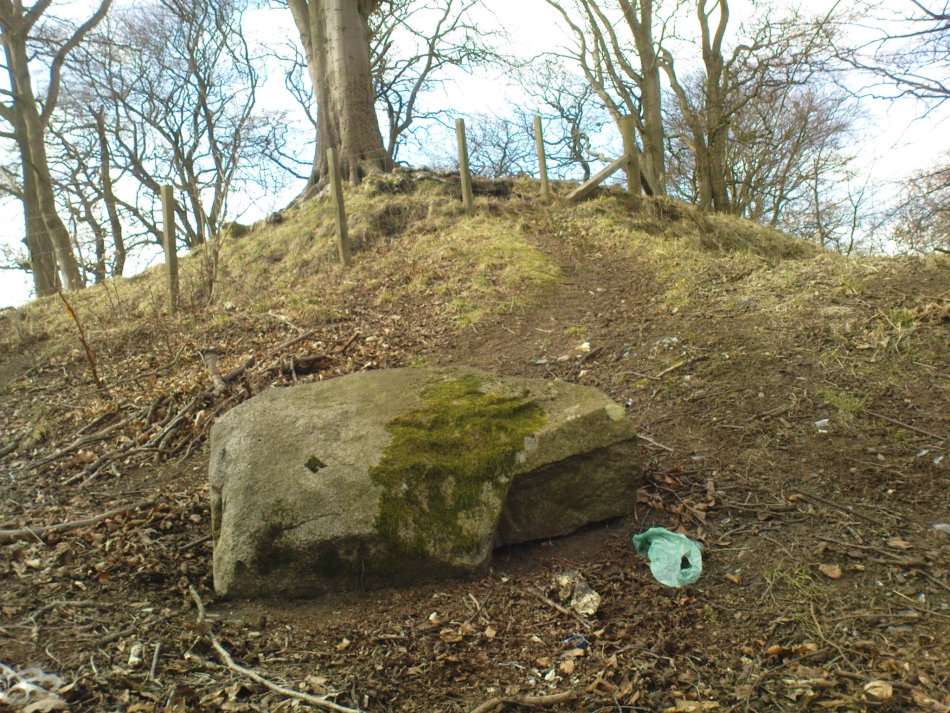
Ascribed by some as neolithic, and others as Bronze Age (the more probable), here is a curious archaeological relic: curious, inasmuch as it’s received very little attention from archaeologists. It’s quite a large monument — and perhaps the fact that it has always seemed to be in isolation from other prehistoric remains has held it back a little. But recent ventures here have brought about the discovery of more cairns (though singular small ones), neolithic walling, hut circles and other prehistoric remains that have never previously been reported.
Miller’s Grave, Midgley Moor (in VERY heavy rain!)Central stone aligning north to Nab End
It’s a decent site aswell. Mainly consisting of the usual mass of smaller stones piled up and around one main point; in the middle of this ‘tomb’ is a large split glacial erratic boulder, which may have been the original focus of the builders. Some may even ascribe a coupla cup-markings on this ‘ere central rock form — but they’d be pushing it a bit! This large central feature aligns to the high peak of Nab Hill several miles north, above Oxenhope. Whether this feature was of any significance in the cairn’s construction is debatable (though as north represents death in pre-christian peasant lore, this ingredient has to be noted).
Profile shot – looking NELooking SE, with small cairn in foreground
The cairn is a goodly size: some 4 feet tall and about 50 foot across at its greatest diameter. Some of the stones near the centre of the stones have been put there in more recent years. In previous centuries, treasure-seekers came here in the hope that they’d uncover gold or other trinkets and stripped off much of the original cover, moving many rocks to the edges. Others were also stolen from here to make some of the grouse-butts, not far from away. In a foray to the site on 5.9.10. we were lucky to find the heather had been burnt back and found, some ten yards to the north and to the southwest, the remains of small, outlying singular cairns (though these need excavating to ascertain their precise nature).
Calderdale Council’s archaeology notes on Miller’s Grave tell it to be “situated on the summit of Midgley Moor”, which is quite wrong. The summit of the moor is some distance west of here, near where an old standing stone called the Greenwood B stone (75 yards south of the Greenwood Stone) and the much denuded remains of other prehistoric sites could once be found — though I’m not sure that they, nor the regional archaeologist for Upper Calderdale has ever been aware of them.
Folklore
In F.A. Leyland’s (c.1869) extensive commentary to Watson’s History of Halifax (1775), he relates a fascinating tale which seems to account for the name of this old tomb:
“About ninety years ago,” he wrote, “that is, towards the end of the eighteenth century – one Lee, a miller, committed suicide in Mayroyd Mill near Hebden Bridge. The jury at the inquest held on the occasion returned a verdict of felo-de-se, and the body was buried at Four Lane Ends, the Rough, in Midgley. The fact, however, of the body of one who had laid violent hands upon himself, lying in unconsecrated ground at a point where the highways met, and at a spot which the inhabitants passed early and late, oppressed the people of the neighbourhood with an irresistible dread. Persons going to market and passing from village to village, feared and avoided the unhallowed spot, until the feeling increased to one of insupportable terror; and, in the night time, a multitude collected with torches to disinter the body. This was speedily effected and violence was even offered to the dead. A man named Mark Sutcliffe, and others, who attempted to prevent the exhumation, were stoned* by the mob, and the body was hurried to the cairn on Midgley Moor, where it was hastily interred. Here however, it was not allowed to rest; the isolation of the body, though buried in a lonely spot, was yet apart from the common cemetery where the dead lie together in their special domain; and this invested the surrounding district with a superstitious awe difficult to describe. The body was still too near the haunts of the living; and, to the perturbed imagination of the inhabitants, the unquiet ghost of the suicide constantly brooded over the hills. As this was not to be endured, the body was at last removed from the cairn, and finally buried in the churchyard of St. Thomas a’ Beckett’s, Heptonstall. Although the interment of Lee, at the cairn, has conferred upon the spot the name of the Miller’s Grave, it cannot be doubted that the large quantity of heavy stones which we find heaped together at this place…was piled up in distant times…”
Modern pagan folklore ascribes the name of this site to relate to Much, the Miller’s Son: acquaintance of the legendary Robin Hood, whose ‘Penny Stone’ boulder is just 100 yards west of here.
Travelling up (north) the A19, just as you get to Riccal village, there’s a small road to your right: take this! A mile along there’s a parking place just where the track veers into the woods. That’s where you’re heading. The remains of the tombs hereabouts can be hard to discern – but if your lucky you’ll either meet a local, or the virtue of patience will bring these overgrown tombs into focus! There are other tumuli a few hundred yards east and north of here aswell. If you wanna get a clear picture of them all, a full day would be a good bet!
Archaeology & History
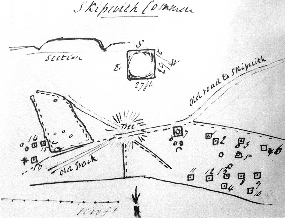
Not to be confused with the other Danes Hills tombs a couple of miles northeast of here (as done on some other sites), the early Victorian geologist and explorer John Phillips (1853) was one of several early writers who described what, today, are known to be Iron Age tombs, scattered about a short distance east of Riccall village, saying:
“On Skipwith Common are many tumuli, old banks, and the slightly-marked foundations of ancient (turf or log?) houses or wigwams. These, by some error of tradition, are called ‘Danes’ Hills/ but, on opening the tumuli, no confirmation of so modern a date appeared. The tumuli are set in square fosses; the sides of the fossae range north and south and east and west (true). Similar facts appear in connexion with the tumuli on Thorganby Common adjacent. Burnt ashes and bones occur in the mounds; facts which suffice to overthrow the supposition of these hills being funeral heaps of the Danes of the llth century, for they then buried their dead. No instruments of metal, bone, or stone, or pottery were found.”
There were dozens of tombs that could be seen here in the past, but today many have been destroyed or are hidden by the cover of trees. A sketch-map (above) showing the rough location of many of the graves was made by the Yorkshire Antiquarian Club after a visit here in 1849 (Proctor 1855), who opened several of the barrows. Archaeologist Ian Stead (1961; 1979) defined these remains as being of the famous La Tene burials — though I’m unsure as to whether any of the tombs here had the great horse-chariots found in them, as found in the more famous Danes Graves tombs close to Driffield.
Folklore
The name of these small hills acquired their Danish title via a mix of real history and folklore. History tells of the old Danish King Harald Hardrada, who moored his fleet of ships a few miles away from here before going into battle against the armies of Northumbria and Mercia. “Dane’s Hill,” said Bogg (c.1895), “still marks the spot where the fight took place.” As John Burton (1758) told us:
“Ever since the aforesaid battle, it is by tradition to this day said, that the Danes were permitted to encamp here till they had buried their dead, and their ships at Riccal should be ready for their re-embarking for Norway.”
Local folk used to tell of the tradition of the local swamp — called Riccal Towdyke — being choked with the bodies of many slain in the battle hereabouts. Many pieces of red cloth were found all around in the neighbourhood of these tombs. However, despite this mix of fact and folklore, the tumuli were see marked on the modern OS-maps have been found to be Iron Age in origin.
…to be continued…
References:
Bogg, Edmund, From Eden Vale to the Plains of York, James Miles: Leeds n.d.
Burton, John, Monasticon Eboracense, N. Nickson: York 1758.
Elgee, F. & H.W., The Archaeology of Yorkshire, Methuen: London 1933.
Morrell, W. Wilberforce, The History and Antiquities of Selby, W.B. Bellerby: Selby 1867.
Phillips, John, The Rivers, Mountains and Sea-Coast of Yorkshire, John Murray: London 1853.
Proctor, W., ‘Report of the Proceedings of the Yorkshire Antiquarian Club, in the Excavation of Barrows from the Year 1849,’ in Proceedings of the Yorkshire Philosophical Society, 1855.
Stead, I.M., ‘A Distinctive Form of La Tene Barrow in Eastern Yorkshire,’ in Antiquaries Journal, volume 41, 1961.
Stead, I.M., The Arras Culture, Yorkshire Philosophical Society: York 1979.
Very close to being at the top of the island. If you do manage to get here take a gander at the legendary Gulf of Corryvreckan: one of the largest whirlpools on Earth, where the cailleach swirled her stuff when angry! This is the ‘hill where sorrel grows,’ and where George Orwell wrote 1984 – but more important for us is where the Royal Commission for Historic & Ancient Monuments of Scotland (Argyll, vol.5) designated that,
“a stony mound about 5.5m in diameter and 0.5m high, situated on the crest of the ridge east of Barnhill, appears to be a prehistoric burial cairn.”
Sadly I never managed to check this out when I was last up here as I didn’t know it was here!
References:
Royal Commission on the Ancient & Historical Monuments of Scotland, Argyll: volume 5 – Islay, Jura, Colonsay and Oronsay, HMSO: Edinburgh 1984.
Follow the same directions to reach the Pancake Stone. Then walk eastwards along the footpath on the moorland edge. After about 400 yards, keep your eye out to your right on the moorland proper where you’ll see this large boulder, seemingly isolated, of similar shape to the Haystack Rock, but a bit smaller. That’s it! If you end up near the stream (Rushy Beck) you’ve gone way past it.
Archaeology & History
Four of the cups on this lichen-rich surfaceLittle Haystack (after Hedges 1986)
Found in the middle of the Green Crag Slack Plain, this large Haystack-Rock-shaped boulder stands out. It sits amidst a cairn-field with other neolithic remains nearby. The carving itself aint that impressive, and some parts of it seem almost dubious. But both Hedges, Boughey and Vickerman include it in their surveys, describing the cup-marks and curious lines on its northeastern surface. It’s nowt special to be honest. You’d expect a bit more from the size of this old stone; but as those folk who know their rock art well will tell you, size aint everything when it comes the splattering of cups on a rock’s surface. We have four distinct cups pretty close to each other (as the photo shows), with another possible cup-and-ring and accompanying lines nearby.
The stone’s worth looking at though. It stands out amidst the mass of single- and double-tombs scattered across the moorland plain — sitting amidst a veritable necropolis no less.
References:
Boughey, Keith & Vickerman, E.A., Prehistoric Rock Art of the West Riding, West Yorkshire Archaeology Service 2003.
Hedges, John (ed.), The Carved Rocks on Rombald’s Moor, WYMCC: Wakefield 1986.
From Threshfield, go up Skirethorns Lane for about 1/2 mile, where the lane takes a sharp right. Continue uphill for nearly 2 miles to a metal gate. Go through the gate, where you’ll see a pair of curious standing stones ahead of you, but instead walk about 250 yards along the line of the old field wall running to the west. You’ll see on the modern OS-map that a ‘cairn’ is shown: this is where you’re heading!
Archaeology & History
First highlighted on the 1852 OS-map of Bordley and district, this is a lovely site in a beautiful setting, surrounded by a veritable mass of other prehistoric remains at all quarters, including the large settlement of Hammond Close immediately south, the little-known settlement at Kealcup to the west, the Lantern Holes settlement up the hill immediately north, some standing stones due east, and much more. Although it was described in Aubrey Burl’s Four Posters (1988) as just such a type of megalithic relic (a “four-poster stone circle”), an earlier description of the site from the mighty pen of Harry Speight (1892) told of a much more complete ring of stones, with trilithon to boot. He wrote:
“This prehistoric relic consists of a round stone and earthen mound, about 150 feet in circumference and 3 feet high, and was formerly surrounded by a circle of upright stones, only three of which are now left standing. On one side was a large flat stone resting upon two others, and known as the Druid’s Altar. On the adjoining land an ancient iron spear-head was found some years ago, and fragments of rudely-fashioned pottery have also from time to time turned up in the same neighbourhood.”
Edmund Bogg’s (1904) description following his own visit a few years later described this “remains of Druidical sacrifice” as consisting of,
“a mound some four feet high, and fifty yards round the outer rim. In the centre are two upright stones about four feet in length; and others nearly buried in the mound. Numerous stones from this circle have been used in building the adjoining walls.”
Bordley Circle, looking SEBordley Hill, looking south to Pendle Hill
A decade later another writer (Lewis 1914) merely copied what Speight and Bogg had recited previously. And whatever the modern books might tell of its status, I think we can safely assert that this was originally a much more substantial monument than the humble four-poster stone circle that meets our eye nowadays. Our megalithic magus, Aubrey Burl (1988), wrote the following on Bordley’s druidical stones:
“On a circular mound 41ft (12.5m) across and 3ft (1m) high, three stones of local limestone form the corners of a rectangle 11ft 6in (3.5m) square, from which the SW stone is missing. At its corner is ‘a stump, possibly the base of a prostrate stone,’ 5ft 10in (1.8m) long, now lying near the centre. The tallest stone, 3ft 7in (1.1m) high is at the south-east. The sides of the square are close to the cardinal points. Between the SW and SE stones is a scatter of round cairnstones… Characteristically, the 4-Poster stands at the edge of a terrace from which the lands falls steeply to the west.”
Plan of the Druid’s Altar (after Burl, 1988)
The Druid’s Altar seems to have originally been a large prehistoric tomb, perhaps even a chambered cairn. Its situation in the landscape where it holds a circle of many outlying hills to attention, almost in the centre of them all, was evidently of some importance. The only geographical ‘opening’ from here is to the south, where a long open valley widens to capture the grandeur of Pendle Hill, many miles away. This would not have been insignificant.
We must also draw attention to what may be a secondary tumulus of similar size and form to the mound that the Druid’s Altar sits upon only some 25 yards to the west of the “circle”. The shape and form of this second mound is similar to that of our Druid’s Circle — though to date, it seems that no archaeologist has paid attention to this secondary feature. It measures some 21 yards (east-west) x 19 yards (north-south) in diameter and has the appearance of a tumulus or buried cairn. The mound may be of a purely geological nature, but this cannot safely be asserted until the attention of the spade has been brought here.
Druid’s Altar, Bordley (drawing by Neil Wingate, 1976)
Folklore
Although we have nothing directly associated with the circle, the surrounding hills here have long been known as the abode of faerie-folk. Threshfield — in whose parish this circle lies — is renowned for it. There have been accounts of curious light phenomena here too. Modern alignment lore tells the site to be related to the peaked tomb above Seaty Hill, equinox west of here.
References:
Bogg, Edmund, Higher Wharfeland, James Miles: Otley 1904.
Burl, Aubrey, Four Posters: Bronze Age Stone Circles of Western Europe, BAR 195: Oxford 1988.
Feather, S.W. & Manby, T.G., ‘Prehistoric Chambered Tombs of the Pennines,’ in Yorkshire Archaeological Journal, Vol 42, 1970.
Lewis, A.L., ‘Standing Stones and Stone Circles in Yorkshire,’ in Man, no.83, 1914.
Raistrick, Arthur, ‘The Bronze Age in West Yorkshire,’ in Yorkshire Archaeological Journal, Vol 29, 1929.
Speight, Harry, The Craven and Northwest Yorkshire Highlands, Elliott Stock: London 1892.
Wingate, Neil, Grassington and Wharfedale, Grassington 1977.