St. Francis’ Well, Dundee, Angus

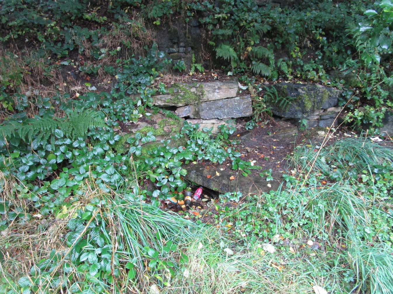
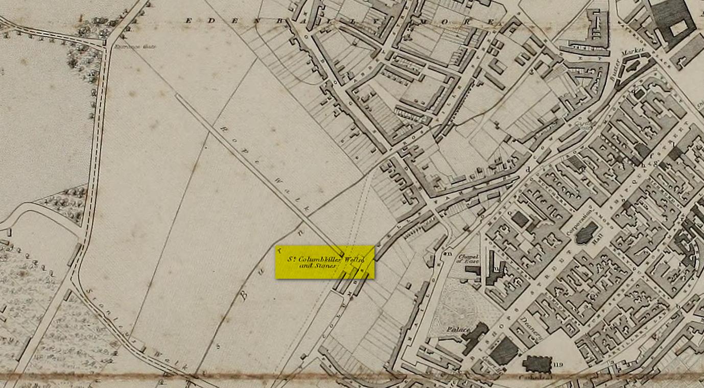
Holy Well (destroyed):  OS Grid Reference – NO 4007 3046

Also Known as:

  1. Grey Friar’s Well

Archaeology & History

Site shown on 1776 map

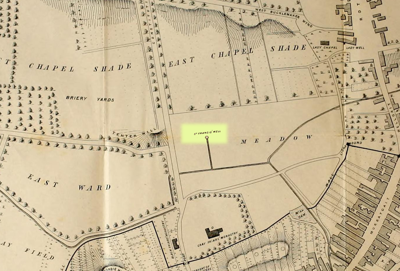
This is another one of Dundee’s lost holy wells (see also the Lady Well, the Nine Wells, St Clement’s Well, St Mary’s Well and Sinavey Well), around which the town was first built.  Its cold fresh waters were located less than a hundred yards north of the old Houff graveyard in the middle of town, or where Alex Maxwell (1884) described as upon “the sunny slopes of the Gray Friars’ meadows.”

Maxwell told us that this sacred site was the most favoured of the the holy wells in the area, having been dedicated to St Francis of Assisi by the monks who built the  medieval Grey Friars monastery, whose ruins lie beneath the Houff graveyard.  After the destruction of the priory in the 16th century, the holy well and surrounding meadows came under the ownership of the local council.  The well had become ruinous and so was repaired back to its old condition, but a few decades later had become very neglected again and was ordered to be closed.  It was mentioned in several early land rental documents, including this from 1630 which told,

“That haugh or meadow lying on the south side of the Tentour Hill, and on the east side of the meadow called Monorgan’s croft, togidder with the lands lying about St. Francis’ well, were set for the yearly penny mail of fifty-ane pounds.”

The most extensive description of it came from Alex Maxwell’s own pen, and I reproduce it here in full.  He began by speaking of the other holy wells of Our Lady and St. Clement’s in Dundee, but told us that,

“The most important of them was the Gray Friars’ well, which came out of the rising ground westward from where the High School is built, and had been dedicated to the honour of St. Francis, the founder of the order — a man of exalted character, whom Dean Milman calls “most blameless and gentle.”  The water, which ran perennially and was of singular purity, had no doubt been highly venerated in the days of the old Church, and it continued to be much esteemed, and even to maintain somewhat of its traditional sanctity, long after the memory of the good man whose name it bore had become forgotten.

“When the Friars’ house was in ruins, and the gardens laid waste, St. Francis’ well did not escape unharmed.  One austere iconoclast—James Patrie was his name—had probably been offended at its sculptural reminiscences of the old faith, and he cast it down.  When arraigned to answer for this,

“he confest and grantit that he took down the common well callit the Friar well, quhilk servit the haill town with guid and wholesome water, and referrit him in the Bailies’ and Council’s will thereanent; and they being advisit with his offence, declarit that he sail pay for the reparation of the said well and common warks the soum of ten pounds; always, gif he big and repair the well as Weill as it wes of before with lime mortar, or Pasch next, this pain to be remitted; otherwise, the day past and the well nocht biggit, to pay the said soum but favour.”

James, however, proved contumacious; the day did pass, and the well still lay in ruins.  But he got further time, for the Council not yet having possession of the monastic lands, had not chosen to act arbitrarily, and 

“James Patrie was ordained to repair the Friar well conform to the last act, under the pain contenit thereintil, betwix the date hereof and Whitsunday;”

and he probably then proceeded to restore it into good condition, as we do not find any other ordinance on the matter.  He had not, however, erected it very substantially; for, before thirty years had elapsed, the structure was again ruinous, and the Council resolved

“that St. Francis’ well be of new biggit and made close, so that na common access be had thereto.”

“The meadow land of the Gray Friars which lay around the well, formed a pleasant open space for the use of the old burgh, and it was always held in much regard. Early in last century, the water from the Lady well was impounded and conveyed in pipes for supplying other cisterns throughout the town ; but St. Francis’ spring, which was softer and purer, was left undisturbed to flow down the grassy slope in its natural course ; and when the place became appropriated for homely purposes, and upon

“Its verdant braes,
The lasses used to wash and spread their claes,”

“the gossiping naiads made the meadow very lively as they plashed in the brimming basins of the Friars’ old well, or filled their pitchers at the fresh fountain, or sprinkled the water in crystal showers over their snowy linen. About the time that the ground was sacrificed for the erection of buildings, a dyer in the neighbourhood sank a well which evidently reached the source of the spring and drained it off. Years afterwards, when the place had been overbuilt, he ceased to use his well, and the stream, returning to its old course, found access into the lower part of a church which now covers the site of the fountain, much to the dismay of the deacons. The water was then carried off elsewhere, and will be seen no more ; and the remembrance of those virtues which belonged to the once famous well will soon have passed away.”

In Christian lore, St Francis’ festival day was October 4.

References:

  1. Maxwell, Alexander, The History of Old Dundee, David Douglas: Edinburgh 1884.

© Paul BennettThe Northern Antiquarian

Holy Well, Huddersfield, West Yorkshire

Holy Well:  OS Grid Reference – SE 12134 15643

Getting Here

Holy Well, full of trash

There are various ways to find this.  When we came here, we started from the Barton and Crosland Moor side, parking up on Ivy Street and walking to the fields at the  end of the road.  From here, walk along the track to your left and just over 100 yards on there’s a small footpath on your right that veers down the slope.  Walk on here for another 100 yards, keeping your eyes peeled for another path on your right that almost doubles-back on you, heading into the trees.  Another fifty yards along and you’ll see some tell-tale stonework!

Archaeology & History

An earlier, adjacent water trough?

Highlighted on the 1854 OS-map, the site has seen better days.  Although the waters today emerge from a blasted rock face and collect into a relatively modern round stone trough, there is a larger square stone structure just a few yards away that seems to have been where water was previously collected.  According to local antiquarian Andy H, this was known to be a local Wishing Well in bygone times, but apart from this there are no literary accounts about the place.  The area was decimated by 19th century Industrialists who, as is well known, destroyed much of our indigenous histories and sites—and the Huddersfield district was particularly hard hit by them.

On a recent visit to the site—in superb pouring rain!—the waters were choked with modern trash and bottles, making it unsafe to drink.  This is surely a good case for restoration, then stuck on some local tourist route to ensure better, more appreciative attention.

Links:

  1. South Crosland Holy Well on The Megalithic Portal

© Paul BennettThe Northern Antiquarian

St. Trunnion’s Well, Barton-upon-Humber, Lincolnshire

Holy Well (destroyed):  OS Grid Reference – TA 026 223

Archaeology & History

This curiously-named, lost holy well was to be found somewhere between the old terrace at West Field and the old road of West Acridge, but even when Henry Ball (1856) wrote about it, the site had passed into history.  He told that,

“In the old enclosures to the west of the town was a spring of clear water called St. Trunnion’s well, and in a field in the West Acridge a very old thorn tree called St, Trunnion’s tree, which was standing in 1736; but who St. Trunnion was is not known…”

The close proximity of the tree with the well is highly likely.  Throughout the British Isles there are many relationships where sacred trees and wells of the same name are next to each other and we have little reason to doubt this was the case here.  However, unless local historians can uncover some old field-name maps, the exact location of the site seems to have been lost.  It was named as St Tronians in 1665; with his sacred tree mentioned in early enclosure awards dated 1681 and 1697 respectively.

The enigmatic saint ‘Trunnion’ is thought to derive, not from some old hermit or heathen holy dood, but from the corruption of an early word: “a perversion of Trin-union or Tri-union, used as an asservation or oath”; although another option cited by Cameron (1991) is that it derives from “trinune, trin-une, referring to the Trinity”—which would explain the sanctification of the waters.

References:

  1. Ball, Henry W., The Social History and Antiquities of Barton-upon-Humber, M. Ball: Barton-upon-Humber 1856.
  2. Cameron, Kenneth, The Place-Names of Lincolnshire – volume 2, EPNS: Nottingham 1991.

© Paul BennettThe Northern Antiquarian

Skirtful Spring, Hawksworth Moor, West Yorkshire

Sacred Well:  OS Grid Reference – SE 13846 44288

Getting Here

Site shown on 1851 map

Easiest way to find this is from the Great Skirtful of Stones.  From here, follow the line of the fence 250 yards south, then climb over and walk dead straight south onto Hawksworth Moor for 150 yards.  You can clearly see the mass of reeds and marshy ground way before you reach it; just be very careful not to walk straight into the reeds or you’ll get sucked down into the waters—and it’s pretty dodgy if you walk into the wrong spot, with good old Jenny Greenteeth lurking beneath the surface!

Archaeology & History

The Skirtful Spring

Highlighted on the 1851 OS-map of the area, this all-but-forgotten clear spring emerges a short distance south of the Great Skirtful of Stones and adjacent to the Hawksworth Moor cairnfield—a proximity that was probably not without meaning in prehistoric times.  Curious though it may sound, in traditional cultures across the world, water is as much an important ingredient in the cosmologies of the dead as it is in the land of the living. In earlier centuries this water-source was much more fast-flowing and wider than it is today and it would obviously have been vital for our prehistoric ancestors.  Its virtues and folklore have long since been forgotten.

© Paul BennettThe Northern Antiquarian

St. Mungo’s Well, Peebles, Peeblesshire

Holy Well (destroyed):  OS Grid Reference – NT 2523 4045

Archaeology & History

St Mungo’s Well, 1858 map

Highlighted on the 1858 OS-map, two-thirds the way up the High Street, this long forgotten sacred well was described by the Ordnance Survey lads in their Name Book (1856) as “an excellent spring”—and no doubt an ever-flowing one, even in the greatest of droughts.  But it had already been destroyed when they came here.  It was mentioned in passing by William Chambers’ (1856), who described it as a “public fountain” dedicated to old Mungo, a.k.a. St Kentigern.  But its position in the High Street wasn’t where it originally emerged.  Local tradition told it was once on the slopes of Venlaw immediately north of the town, possibly making it into the folklore category of “Wells that Move”—usually because the spirit of the place has been offended.

But in truth, little is known about its mythic history.  Its origin seems, as with so many ancient sites, entangled in what Dr Gunn (1908) in his definitive work on the history of Peebles church explained, the heathen “superstitious regard for fountains”, pre-dating the christian dedications.  St Mungo himself, said Gunn,

“is remembered in Peebles to-day by his holy well upon the slopes of Venlaw, hallowed by its use in the Sacrament of Baptism.”

It’s profane history tells simply that, in 1728, its waters were piped into the trough on High Street for public use.  It became damaged sometime in the early 19th century, but some remains of the  stonework were found when roadworks were done here in 1845.  It would be good if we could recover further information about this important holy well.

References:

  1. Chambers, William, A History of Peeblesshire, W. & R. Chambers: Edinburgh 1864.
  2. Gunn, P., The Book of Peebles Church, A. Walker: Galashiels 1908.

© Paul BennettThe Northern Antiquarian 


Bishop’s Well, Stow, Midlothian

Holy Well (destroyed):  OS Grid Reference – NT 4598 4454

Archaeology & History

At the edge of the ruins known as the Bishop’s Palace, up the slope behind the ruined church in Stow, could once be seen the waters of the Bishop’s Well which, wrote Thomas Wilson (1924), fed the palace hereby and was used by the clergy.  Apart from a barely discernible circular depression at the edge of the old manse ruins, no trace of this site remains.

References:

  1. Royal Commission Ancient & Historical Monuments, Scotland, Inventory of Monuments and Constructions in the Counties of Midlothian and West Lothian, HMSO: Edinburgh 1929.
  2. Wilson, Thomas, The Stow of Wedale, Aberdeen Newspapers 1924.

© Paul BennettThe Northern Antiquarian

St. Columba’s Well, Derry, Co. Derry

Holy Well (destroyed):  OS Grid Reference – C 43117 16615

Archaeology & History

Long since gone, there are very few references to this once sacred site, which seemed to comprise of three sacred wells next to each other, each with its own formal dedication.  This would have made it one fuck of an important place in early- and pre-christian times.  But even when Thomas Colby (1837) and his mates surveyed the area, it seems like it was on its last legs.  He told that:

Site on Colby’s 1837 map

“As connected with the ancient history of Derry the sacred springs, called St. Columb’s Wells, claim some notice in this place.  They are, or rather were, three in number — for one has been dried up, or diverted from its original locality — and are situated near the Roman Catholic chapel, outside the wall.  It appears from the Irish annals that each of these wells had its peculiar name, one being called Tobar Adamnam, another Tobar Martain, and the third Tobar Colum — but the two former names are now quite forgotten, and the springs are popularly called St. Columb’s Wells.  They are regarded with much superstitious veneration by the Roman Catholic peasantry, but no celebration of St. Columb’s festival is now held at them.”

The wells were found very close to St. Columba’s bullaun stone, which possessed its own healing abilities.  The two sites had symbiotic ceremonial relationships with each other, doubtless performed in bygone centuries on St. Columba’s old festival date of June 9.

References:

  1. Colby, Thomas, Ordnance Survey of the County of Londonderry, HMG: Dublin 1837.
  2. Doherty, William, Derry Columbkille, Brown & Nolan: Dublin 1899.

© Paul BennettThe Northern Antiquarian 

College Well, Brechin, Angus

Sacred Well:  OS Grid Reference – NO 5945 6006

Archaeology & History

College Well on 1865 map

Highlighted on the 1865 OS-map, this lost water source was located between the Brechin cathedral/round tower and the curiously-named St. Michael’s Mount, whose history seems to be lost.  It would seem to be the well which Ruth & Frank Morris (1981) name as the ‘Ancient Well’ in their survey.

Folklore

The reason behind this site being classified as a sacred (or holy) well is based on the tradition that the Culdees had a religious convent here in the 12th century and, according to David Black (1839),

“This convent is believed to have stood a little to the west of the present parish church, in the gardens now belonging to the kirk-session, still called “the College Yards.”  A small well of delightfully pure water in these gardens receives the name of the College Well, and is reported, by tradition, to have been the well of the Culdee convent.”

On the issue of St. Michael, students of folklore will know that, in the christian cult, he was an early dragon-slayer.  His annual commemoration day is September 29.  One of his shamanistic functions “relates to the very old tradition of Michael as the receiver of the souls of the dead.” (Attwater 1965)

References:

  1. Black, David D., The History of Brechin, Alexander Black: Brechin 1839.
  2. Gibson, Colin, Folklore of Tayside, Dundee Museum c.1968.
  3. Morris, Ruth & Frank, Scottish Healing Wells, Alethea: Sandy 1982.

© Paul BennettThe Northern Antiquarian

Acknowledgements:  Huge thanks for use of the 1st edition OS-map in this site profile, Reproduced with the kind permission of the National Library of Scotland

Holy Well, Kislingbury, Northamptonshire

Holy Well (lost):  OS Grid Reference – SP 698 575

Archaeology & History

Hollowell Farm on 1885 map

A mile south of Kislingbury village, just by the roadside is the old Hill Farm.  In times gone by—as the early OS-maps show—a trackway led from here, westwards, for just a few hundred yards, until it reached the old farm of Hollowell Hill, all trace of which has long since gone.  The farm owed its name to the existence of a holy well mentioned briefly in 14th century records in the Cartulary of St. Andrews, Northampton, where it was described as Halywellhille, or the Holy Well on a hill.  All trace of it seems to have been lost.  A ‘Spring’ that is shown on the 1885 map, a few hundred yards south of the old farm, seems to be the closest contender, but it seems more likely that the well was adjacent to, or beneath the farm-building.

References:

  1. Gover, J.E.B., Mawer, A. & Stenton, F.M., The Place-Names of Northamptonshire, Cambridge University Press 1975.

© Paul BennettThe Northern Antiquarian

Dragon Well, Eccleshill, Bradford, West Yorkshire

Sacred Well (destroyed):  OS Grid Reference – SE 17567 35473

Also Known as:

  1. Pendragon Well

Archaeology & History

Site on the 1893 map

A most curious place:  this ‘Well of the Dragon’ as it was first called (on the 1852 OS-map) and subsequently the ‘Pendragon Well’ (on the 1922 map) just off Pendragon Lane, seems to have been forgotten in both folklore and history.  I grew up round here and no legends of dragons were known, either in my life, nor that of the old folks I knew; nor any pub of that name that might account for it.

Equally unexplained is the name of the adjacent ‘Pendragon Lane’, which has been known as that for some 175 years.  We have no Arthurian myths anywhere in West Yorkshire that remains in folk memory—and certainly nothing hereby that accounts for it.

As for possible landscape associations (i.e., serpentine geological features), nothing in the vicinity has any bearing on the name.  Indeed, the only thing of any potential relevance was the former existence of a healing rock known as the Wart Stone, some 100 yards to the east at Bolton Junction.  Such stones are usually possessed of naturally-worn ‘bowls’ of some sort on top of the rock—akin to large cup-markings—into which water collected that was used to rid the sufferer of warts or similar skin afflictions.  But such an association seems very unlikely.

The only thing we can say of this Dragon Well is that probably, in times gone by, a folktale or legend existed of a dragon in the neighbourhood that had some association with the waters here.  Dragons are invariably related to early animistic creation myths, and this site may have been all that remained of such a forgotten tale.  The nearest other place in West Yorkshire with dragon associations is six miles northwest of here on the south-side of Ilkley Moor.  In Britain there are a number of other Dragon Wells, the closest of which is in South Yorkshire.

© Paul BennettThe Northern Antiquarian