Crowan Cross, Kerrier, Cornwall

Cross (remains):  OS Grid Reference – SW 6456 3449

Getting Here

Photo from abaat 20yrs ago

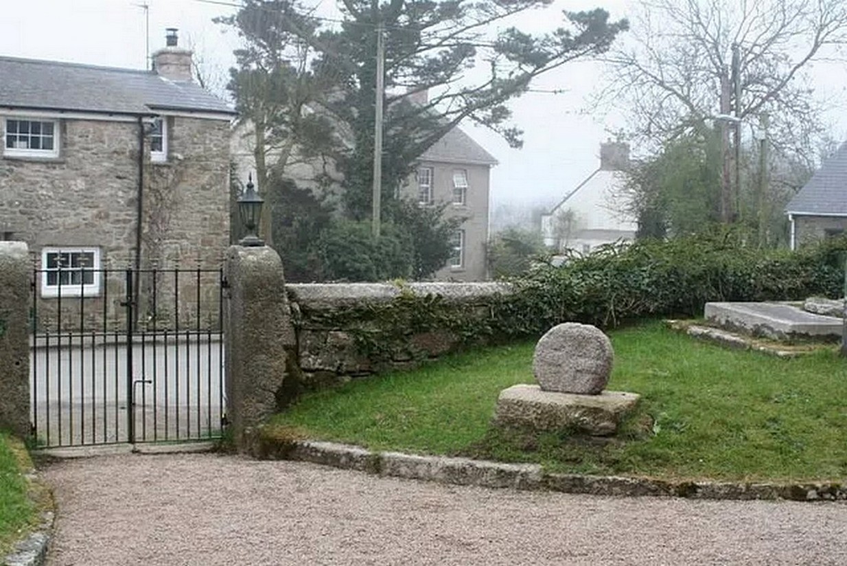
Nice ‘n easy: get into the village and walk through the church gates and there, on your left on the grass verge, a plinth and the cross-head sits before thee!

Archaeology & History

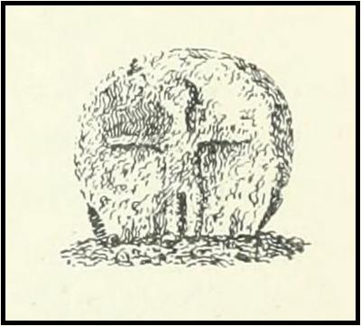
When the great Arthur Langdon (1896) wrote about Crowan’s cross-head, he was puzzled.  At the time it was in the garden of a local surveyor in the nearby village of Praze-an-Beeble, but its origins seemed mysterious.  The surveyor in question, a Mr William Carah, wrote to Langdon and said,

“It seems a mystery where the cross we have originally came from.  A friend of mine, living abroad at present, saw it, I think, at a farm-place, being used as a bottom for a beehive.  He asked the people for it, intending to fix it somewhere.  At any rate, when he left England he had not done so, and at my request they gave the cross to me.”

The condition of the cross-head wasn’t too good and Langdon suggested it had “received some very rough treatment” – no doubt when it was hacked from its shaft.   With his usual precision he gave the dimensions of the cross-head as follows:

“Height, 1 ft. 6 in.; width, 1 ft. 8 in.; thickness: at the bottom 6½ in., at the top 5½ in.

Front. — Part of a small conventional figure of Christ, extending to the knees, at which point the fracture occurred which separated the head from the shaft.

Back. — The remains of a mutilated Latin cross in relief.”

The stone shaft or menhir that once supported this carved head has, it would seem, long since been destroyed.

References:

  1. Blight, J.T., Ancient Crosses and other Antiquities in the West of Cornwall, Simpkin Marshall: London 1858.
  2. Courtney, R.A., The Evolution of the Wheel Cross, Beare & Sons: Penzance 1914.
  3. Doble, Gilbert H., A History of the Parish of Crowan, King Stone Press: Shipston-on-Stour 1939.
  4. Langdon, Andrew, Stone Crosses in West Cornwall, Federation of Old Cornwall Societies 1999.
  5. Langdon, Arthur G., Old Cornish Crosses, Joseph Pollard: Truro 1896.

© Paul BennettThe Northern Antiquarian

St. Stephen’s Well, Banbury, Oxfordshire

Holy Well (destroyed):  OS Grid Reference – SP 4506 4055

Archaeology & History

Well highlighted, in 1730

The holy well of Banbury seems to have been destroyed sometime in the second-half of the 19th century, when the industrialists built over the area.  When the historian Alfred Beesley (1841) wrote about it, the waters were still running.  He told it to be, “a chalybeate spring, well-known and still often visited, situated on the west side of the town, a little north of the footway leading to North Newington.”

The footpath is obviously long gone—as is the well.  It’s iron-bearing (chalybeate) properties would have given the waters good fortifying properties, perhaps of some renown to local people yet, according to Mr Beesley, it was a slow-flowing spring.  In his brief history of the site, he also gave us the results of a chemical examination of its healing waters, telling us:

“This is called St. Stephen’s Well in a plan of Sir John Cope’s property at Banbury made in 1764. It also appears prominently as “A Well ” in an unfinished view of Banbury made in 1730 (illustrated above)….

The water of this spring is perfectly clear and colourless, having a brisk and slightly chalybeate taste. The stone channel is coated with a light red deposit, and a scum of the same colour appears on the water in parts where stagnant. The spring discharges from half a gallon to one gallon in a minute.  In 32 oz. of the water at 60° are,

Carbonic Acid gas, 5 cubic inches
Hydrochlorate Magnesia, 0.21 grains.
Chloride Sodium or common Salt, 0.54
Sulphate Lime, 1.5
Carbonate Lime, 3.8
Protoxide Iron, 0.024
Silica a trace
Total weight of solid contents – 6.074″

Folklore

St. Stephen is an odd character.  His annual celebration or feast day in Britain is December 26. (in eastern countries it’s a day later)  Rites connected to this character are decidedly heathen in nature.  From the 10th century, in England, St Stephen’s Day has been inexorably intertwined with horses, bleeding them on his feast days, apparently for their own health.  Water blessed by priests on this day would be kept for the year and used as a medicine for horses during that time. Also on this day, young lads would “hunt the wren” and, once caught, impale it on top of a long pole and take it from house to house.  Despite this curious motif being a puzzle to folklore students, Mircea Eliade (1964) explained how this symbolism is extremely archaic and “the bird perched on a stick is a frequent symbol in shamanic circles.”

References:

  1. Beesley, Alfred, The History of Banbury, Nichols & Son: London 1841.
  2. Eliade, Mircea, Shamanism – Archaic Techniques of Ecstasy, Princeton University Press 1964.
  3. Harte, Jeremy, English Holy Wells – volume 2, Heart of Albion press: Wymeswold 2008.
  4. Johnson, William P., The History of Banbury, G. Walford: Banbury 1860.

Acknowledgements:  Huge thanks for use of the Ordnance Survey map in this site profile, reproduced with the kind permission of the National Library of Scotland

© Paul BennettThe Northern Antiquarian

The Spinsters’ Rock, Drewsteignton, Devon

Dolmen:  OS Grid Reference – SX 70092 90783

Also Known as:

  1. Drewsteignton (1)

Archaeology & History

Highlighted on Benjamin Donn’s map of Devon in 1765, this impressive neolithic dolmen consists of three large granite support stones between 5 ft 7 in and 7 ft 7 in tall, surmounted by a large capstone measuring 15 feet by 10 feet.  It collapsed in 1862 but was restored later the same year.


Folklore

In Murray’s (1851) Handbook for Travellers he told the following tale of the site:

This interesting old monument derives its name from a whimsical tradition that three spinsters (who were spinners) erected it one morning before breakfast; but “may we not,”* says Mr. Rowe (Peramb. of Dartmoor), “detect in this legend of the three fabulous spinners the terrible Valkyriur of the dark mythology of our Northern ancesters – the Fatal Sisters, the choosers of the slain, whose dread office was to ‘weave the warp and weave the woof of destiny.'”

Polwhele informs us that the legend varies, in that for the three spinsters some have substituted three young men and their father, who brought the stones from the highest part of Dartmoor; and in this phase of the legend has been traced an obscured tradition of Noah and his three sons.

.. The hill on which it stands commands an excellent view of Cawsand Beacon. About 100 yds. beyond the cromlech on the other (N.) side of the lane, is a pond of water, of about 3 acres, called Bradmere Pool, prettily situated in a wood. It is said to be unfathomable, and to remain full to the brim during the driest seasons, and some regard it as artificially formed and of high antiquity – in short a Druidical pool of lustration connected with the adjacent cromlech..

.. The country-people have a legend of a passage formed of large stones leading underground from Bradmere to the Teign, near the logan stone..

References:

  1. Baring-Gould, Sabine, A Book of Dartmoor, London 1900.
  2. Crossing, William, Gems in a Granite Setting, Western Morning News: Plymouth 1905.
  3. Falcon, T.A., Dartmoor Illustrated, James G. Comin: Exeter 1900.
  4. Murray, John, A Hand-book for Travellers in Devon & Cornwall, John Murray: London 1851.
  5. Ormerod, G. Waring, Notes on Rude Stone Remains Situate on the Easterly Side of Dartmoor, privately printed 1873.
  6. Page, John Lloyd Warden, An Exploration of Dartmoor and its Antiquities, Seeley: London 1892.
  7. Worth, R. Hansford, Worth’s Dartmoor, David & Charles: Newton Abbot 1967.

Acknowledgements:  Huge thanks for use of the Ordnance Survey map in this site profile, reproduced with the kind permission of the National Library of Scotland

© Paul BennettThe Northern Antiquarian

Hardwick Maypole, Whitchurch, Oxfordshire

Maypole (destroyed):  OS Grid Reference – SU 655 781

Archaeology & History

“g” marks the spot!

Very little is known about the history surrounding Whitchurch’s maypole that once stood more than a mile east of the village, somewhere in the woods immediately south of the present-day cannabis-growing Hempem Organics. (damn those hippies!)  Mentioned in the Enclosure Acts of 1806 and 1813 as the “May Pole Ground”, the monument was mentioned in the Rev. John Slatter’s (1895) local history work and its approximate location was shown on a hand-drawn map he did of the area, in the grounds north of Hardwick House.  He told us that it stood on “an elevated site” and conjectured that it might once have been a place of druidical worship!

“In the centre of the Hardwick property is a plot of ground called the Maypole Piece…. It is an open space, with a tree standing alone, where we may suppose the maypole formerly stood. There is a memorandum made by the last Mrs. Lybbe (nee Isabella Twysden) to this effect:

1713: A maypole set up on ye hill in ye straight way to Collinsend.”

In the event that you manage to discover anything else about the history of this maypole, let us know on our Facebook group.

References:

  1. Gelling, Margaret, The Place-Names of Oxfordshire – volume 1, Cambridge University Press 1953.
  2. Slattter, John, Notes on the History of the Parish of Whitchurch, Elliot Stock: London 1895.

© Paul BennettThe Northern Antiquarian

St. Helen’s Well, Colchester, Essex

Holy Well (destroyed):  OS Grid Reference – TL 997 254

Archaeology & History

Near the centre of the ancient city could once be found the flowing waters of St. Helen’s Well.  It was described many times in various legal and land documents from as early as 1331 CE onwards, in Colchester’s Oath Book.  However, descriptions of the site itself and its curative abilities were not noted.  It was simply associated with St Helen’s Chapel, whose original foundations date from the 12th century.

Folklore

One tradition told that it was St Helen herself who founded the chapel here.  St Helen’s feast day is Agust 18.

References:

  1. Benham, W. Gurney (trans.), The Oath Book; or, Red Parchment Book of Colchester, Essex County Standard: Colchester 1907.

© Paul BennettThe Northern Antiquarian

Holy Well, Watford, Hertfordshire

Holy Well (destroyed):  OS Grid Reference – TQ 102 952

Archaeology & History

A long lost sacred site (not to be confused with the nearby Bright Well) that has given its name to the district of Holywell.  It also gave its name to an early farmstead; and to the place-name of Holywellane recorded as far back 1485.  It was also described as a “Holy Well” in a local vestry book in 1698.  Nothing more seems to be known of the place.

References:

  1. Gover, J.E.B., Mawer, Allen & Stenton, F.M., The Place-Names of Hertfordshire, Cambridge University Press 1938.
  2. Harte, Jeremy, English Holy Wells – volume 2, Heart of Albion press: Wymeswold 2008.

© Paul BennettThe Northern Antiquarian

Vicarage Well, North Mymms, Hertfordshire

Holy Well (destroyed):  OS Grid Reference – TL 2214 0449

Archaeology & History

An early reference by Nathaneal Salmon (1728) told that in the grounds of St. Mary’s church by the vicarage there was a well, which may or may not have been deemed as ‘holy’.  He wrote:

“There is a Dale in Coppice belonging to the Manor of Potterels, from which, after a great Quantity of Rain, the Water comes through Veins of Chalk to the Vicarage Well, and is white.”

No well is shown on the early OS-maps at this place and we can only assume that it was either capped or had fallen back to Earth not too long after Salmon’s visit.

References:

  1. Salmon, N., The History of HertfordshireDescribing the County and its Monuments, London 1728.

Acknowledgements:  Huge thanks for use of the Ordnance Survey map in this site profile, reproduced with the kind permission of the National Library of Scotland

© Paul BennettThe Northern Antiquarian

St. Sennen’s Well, Sennen Cove, Cornwall

Holy Well (lost):  OS Grid reference – SW 3550 2626

Archaeology & History

The springs of Chapel Idne

Highlighted on the 1888 Ordnance Survey map of Sennen Cove are the remains of Chapel Idne, just above the coast.  Across the road from the chapel on its south-side, and also next to an old inn to its immediate west, springs of water are shown and it would seem more than likely that one of these two would have been the forgotten holy well of Sennen that was described, albeit briefly, in the great Mr Blight’s (1861) literary tour of the area.  He told us that:

“At Sennen Cove was an ancient chapel, called by the people Chapel Idne, the “narrow chapel” being forty-five feet long and fifteen feet wide.  It is now converted into a dwelling. Tradition says it was founded by one Lord of Goonhilly, who possessed dome portion of the land of Lyonesse.  There was a holy well of some repute here also.”

The waters of St. Sennen’s Well were used in an act of ceremonial magick in the Arthurian tale known as the Battle of Vellan-druchar, as told in Robert Hunt’s (1865) great Romances.  An attempted invasion by the Danes was met with by Arthur and nine other kings and the foreigners were slaughtered.

“A few had been left in charge of the ships, and as soon as they learned the fate of their brethren, they hastened to escape, hoping to return to their own northern land. A holy woman, whose name has not been preserved to us, “brought home a west wind” by emptying the Holy Well against the hill, and sweeping the church from the door to the altar.  Thus they were prevented from escaping, and were all thrown by the force of a storm and the currents either on the rocky shore, or on the sands, where they were left high and dry.  It happened on the occasion of an extraordinary spring-tide, which was yet increased by the wind, so that the ships lay high up on the rocks, or on the sands; and for years the birds built their nests in the masts and rigging.

Thus perished the last army of Danes who dared to land upon our western shores.

King Arthur and the nine kings pledged each other in the holy water from St Sennen’s Well, they returned thanks for their victory in St Sennen’s Chapel, and dined that day on the Table-men.

Merlin, the prophet, was amongst the host, and the feast being ended, he was seized with the prophetic afflatus, and in the hearing of all the host proclaimed–

“The northmen wild once more shall land,
And leave their bones on Escol’s sand.
The soil of Vellan-Druchar’s plain
Again shall take a sanguine stain;
And o’er the mill-wheel roll a flood
Of Danish mix’d with Cornish blood.
When thus the vanquish’d find no tomb,
Expect the dreadful day of doom.”

References:

  1. Blight, J.T., A Week at the Land’s End, Longmans Green: London 1861.
  2. Hunt, Robert, Popular Romances of the West of England, 1865.
  3. Straffon, Cheryl, “Chapel Idne and the Holy Well,” in Meym Mamvro no.34, 1997.
  4. Weatherhill, Craig, “A Guide to Holy Wells and Celebrated Springs in West Penwith,” in Meym Mamvro no.4, 1997.

Acknowledgements:  Big thanks for use of the early edition OS-map in this site profile, Reproduced with the kind permission of the National Library of Scotland

© Paul BennettThe Northern Antiquarian

Mineral Well, Upper Norwood, Surrey

Healing Well (destroyed):  OS Grid Reference – TQ 318 703

Archaeology & History

This was one of several so-called mineral springs in and around the Norwood area, but seemingly the least well-known—certainly in literary terms.  Whatever renown it may once have had was overwhelmed by the relative proximity of the much more famous curative waters of the Beulah Spa, a few hundred yards to the southeast.  It was mentioned, albeit briefly and already in the past tense, in John Anderson’s (1898) survey, when he told that “There used to be (a) mineral well at Biggin Hill. It is marked on the Croydon Inclosure Map” of 1800 and shown as a “Spring”, north of Biggens Farm.  It seems that it had only just been destroyed when Anderson wrote about it, as the research of Alfie Foord (1910) showed. His inquiries found that,

“There used to be another mineral well about half a mile to the north-west of Beulah Spa, at Biggin Hill, the water from which gushed up at the rate of seven gallons a minute.  In 1898 it was closed.  The subjoined analysis of water from a well, which is at White Lodge, Biggin Hill, formerly the residence of Mr. H. Wilson Holman, was kindly supplied by him to the writer in 1907.  This well, he says, undoubtedly taps the same spring that used to come out at the bottom of Biggin Hill, and which was blocked by the sanitary authorities in 1898.  The site of the spring was beyond the small tenement houses at the bottom of the hill, and there is still some masonry in existence—the end of the culvert where the water used to run out into a pond.  The reason of its being blocked was that it is alleged to have poisoned some domestic animal.”

References:

  1. Anderson, John C., The Great North Wood, Blades: London 1898.
  2. Foord, Alfred Stanley, Springs, Streams and Spas of London: History and Association, T. Fisher Unwin: London 1910.
  3. Gover, J.E.B., Mawer, A. & Stenton, F.M., The Place-Names of Surrey, Cambridge University Press 1934.

© Paul BennettThe Northern Antiquarian

Maiden’s Well, Launceston, Cornwall

Holy Well (destroyed):  OS Grid reference – SX 3285 8477

Archaeology & History

Very little is known about this holy well on the north-western side of town that was apparently destroyed sometime in the 19th century; for when the Ordnance Survey lads visited here in 1882, they found no running water but only the location of where it had been and they indicated this on their 1884 map of the area, marked as “Site of.”

Site of well on 1884 map

It was first mentioned in a short topographical notice in 1582, which told that the “Magden Well in the Quarrie Haye”—along with another well—was “found to be in decay.” (Peter 1885)  Then, when the Ordnance Survey lads resurveyed the area once more in 1951, they could find no trace of it.  It was mentioned in passing in Peter’s (1885) local history work, but there seems to be little else written about the place, which is a little odd for this part of the world.  Anyone know anything more…?

References:

  1. Peter, Richard, The Histories of Launceston and Dunheved, W. Brendon: Plymouth 1885.

Acknowledgements:  Big thanks for use of the early edition OS-map in this site profile, Reproduced with the kind permission of the National Library of Scotland

© Paul BennettThe Northern Antiquarian