Stone Circle (destroyed): OS Grid Reference – NX 691 447
Archaeology & History
In an area littered with neolithic and Bronze Age remains, the great Fred Coles (1895) reported a stone circle that was destroyed sometime roughly between 1890 and 1911. When he visited the place with his colleague, Mr E.A. Hornel in 1887, the megalithic ring had already been tampered with. It was, he said,
“found to consist of five granite boulders, all of them large, in situ, and the ridgy grassy hollows of five others—removed, no one can say when. In the centre of this nearly true circle, 90 feet in diameter, is a slight mound, possibly artificial.”
In 1911, when the Royal Commission lads visited the area, they could find no stone circle and reported how “no information could be obtained concerning it” from the local farmer. This might have been because he destroyed it. Some land-owners do such things, as we know; but in this case we may never know.
The site was listed without comment in the Master’s magnum opus (Burl 2000), but he gave it the “uncertain status” category; whilst John Barnatt (1989) questioned whether this was a destroyed stone circle or merely a natural setting that Cole had misinterpreted.
References:
Barnatt, John, Stone Circles of Britain– volume 2, BAR: Oxford 1989.
Burl, Aubrey, The Stone Circles of Britain, Ireland and Brittany, Yale University Press 2000.
Royal Commission Ancient & Historical Monuments, Scotland, Inventory of Monuments and Constructions in Galloway – volume 2: County of the Stewartry of Kirkcudbright, HMSO: Edinburgh 1914.
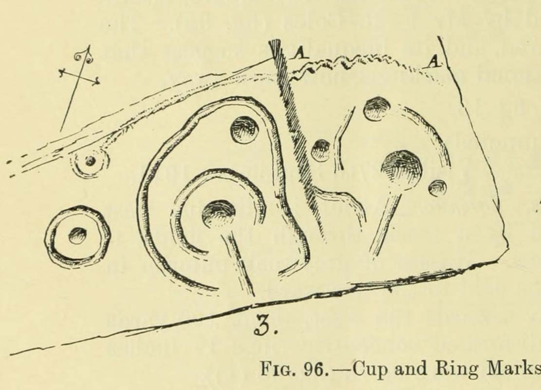
Amongst a good cluster of petroglyphs, this ornate little fella may have been one visited by George Hamilton (1886) when he visited Balmae and outlying districts, seeking out petroglyphs! We don’t know for certain though, as his descriptions are somewhat vague. However, a few years later the great Fred Coles (1895) came a-wandering in search of the same carvings and, as happens in this line of business, uncovered a few new ones during his rummaging. This was one of them, which he described, very simply, as hiding
“but a few yards from Ross View Cottage, on its N.W. … (with) eight cups being associated with four rings and several grooves, both straight and curved.”
It was only a few years later when the Royal Commission lads (1911) came in search of it and they told how,
“the main design is a central ringed cup with a connected groove, and two outer cups which an outer circle curves eccentrically to enclose.”
But when Ron Morris (1979) explored the area in the 1970s, he was unable to locate this and a number of other carvings that had been reported by Coles. Since then, the carving has been relocated at the grid reference cited above. Also since then, a great deal many more carvings have been found in this locale by the experienced petroglyphic fingers of Maarten van Hoek. (1993)
Morris, Ronald W.B., The Prehistoric Rock Art of Galloway and the Isle of Man, Blandford: Poole 1979.
Royal Commission Ancient & Historical Monuments, Scotland, Inventory of Monuments and Constructions in Galloway – volume 2: County of the Stewartry of Kirkcudbright, HMSO: Edinburgh 1914.
van Hoek, M., “Balmae”, in Discovery & Excavation Scotland, 1993.
Healing Wells (destroyed): OS Grid Reference – TQ 3094 7889
Also Known as:
Lambeth Spa
Near Well and Far Well
Archaeology & History
This once famous healing or spa well has long gone. It was located where the buildings that now constitute 104-105 Lambeth Walk presently stand: an area which the great London historian William Thornbury (1878) told was already “a favourite resort of Londoners, and celebrated for the variety of sweet-smelling flowers and medicinal herbs growing there,” complementing the healing waters before and during the spa craze. The great herbalist John Gerard did his collections here.
I can find no information regarding its early use by our peasant ancestors, so its written history simply begins when it had been appropriated by those well-to-do up-market types who took this medicinal spring for their commercial gain in the early days of the trendy spas. Supplied by two separate springs known as the Nearer and Farther Wells respectively, the Well House built here was “formally opened in April 1696” and subsequently had almost daily accompaniments of music, including French and country dancing! But as the popularity of the Lambeth Spa increased, so did its problems. Phyllis Hembry (1990) told that by July 1715, one visitor to the spa,
“was so depressed to find that the many people there were mostly rakes, whores and drunkards, idlers such as Guard officers, or young pleasure-seeker like attorneys’ clerks, mingling with loose women of the the meanest sort. The Lambeth Wells also became a public nuisance, so a dancing license was refused in 1755.”
The so-called Great Room which had been the place of great occasions by spa users ended up being the meeting place “for Methodist meetings.” Oh how the winter nights must have flown by…..
There was a decided improvement in the years that followed and social events at the spa increased again. It became what Thornbury said “was another place of amusement.” The Lambeth Wells, he wrote,
“were held for a time in high repute, on account of their mineral waters, which were advertised as to be sold, according to John Timbs, at “a penny a quart, the same price paid by St. Thomas’s Hospital.” About 1750, we learn from the same authority, there was a musical society held here, and lectures, with experiments in natural philosophy, were delivered by Dr. Erasmus King and others. Malcolm tells us that the Wells opened for the season regularly on Easter Monday, being closed during the winter. They had “public days” on Mondays, Thursdays, and Saturdays, with “music from seven in the morning till sunset; on other days till two!” The price of admission was threepence. The water was sold at a penny a quart to the “quality” and to those who could pay for it; being given gratis to the poor. We incidentally learn that there were grand gala and dancing days here in 1747 and 1752, when “a penny wedding, in the Scotch manner, was celebrated for the benefit of a young couple.”
By this time, a rival St. George’s Spa of had been created a short distance away on the parish boundary and with it, the popularity and attendance at Lambeth Wells began to decline. By the end of the 18th century, the rot had truly set in and its days were finally numbered.
As for the medicinal properties of these wells, little seems to have been recorded. Aside from repeating the common description of them being mineral waters, William Addison (1951) simply added that they were also purgative.
References:
Addison, William, English Spas, Batsford: London 1951.
Long since gone, this great olde ash tree could once be found on the south side of Killin’s Mill building, close to the bridge at the Falls of Dochart. It was deemed to be ‘sacred’ by local people – just as all trees were, once upon a long time ago.
In John Shearer’s (1883) wonderful book on the ancient ways of the Perthshire people, he described the tree as being adjacent to the earthfast rock known as St. Fillan’s Seat:
“At the side of it grows a large ash tree which is held sacred by the natives as no person will burn any of the branches although fallen to the ground nor destroy them in any manner. However, there was one who had the hardihood to take one of the branches for a caber to repair his house. Strange to tell the first fire that was kindled burned it to the ground as a punishment for this impious sacrilege. Of course no person since has troubled it or taken any of the wood. The branches that fall lie till they rot.”
The brilliant Killin historian, W.G. Gillies (1938) reported that the tree was still standing until it was “blown down by a gale in 1893″—but it didn’t quite kill it off for good; for in September 1911, C.G. Cash visited Killin and this was one of the many places he looked for and, despite local folk telling him about the more famous St Fillan Stones (still in existence and found at the Mill), he saw the last remnants of this great Ash, telling simply that,
“the mere dead stump of St Fillan’s Ash-tree still stands against the south post of the mill gate. And quite near it is a young ash, said to be its descendant. This younger tree has an out-curving branch that was said to have been the gallows-branch in olden days; but it is obviously too young and too weak.”
…So, does anyone know precisely which is the “descendant” of St. Fillan’s Ash and where happens it to be growing?
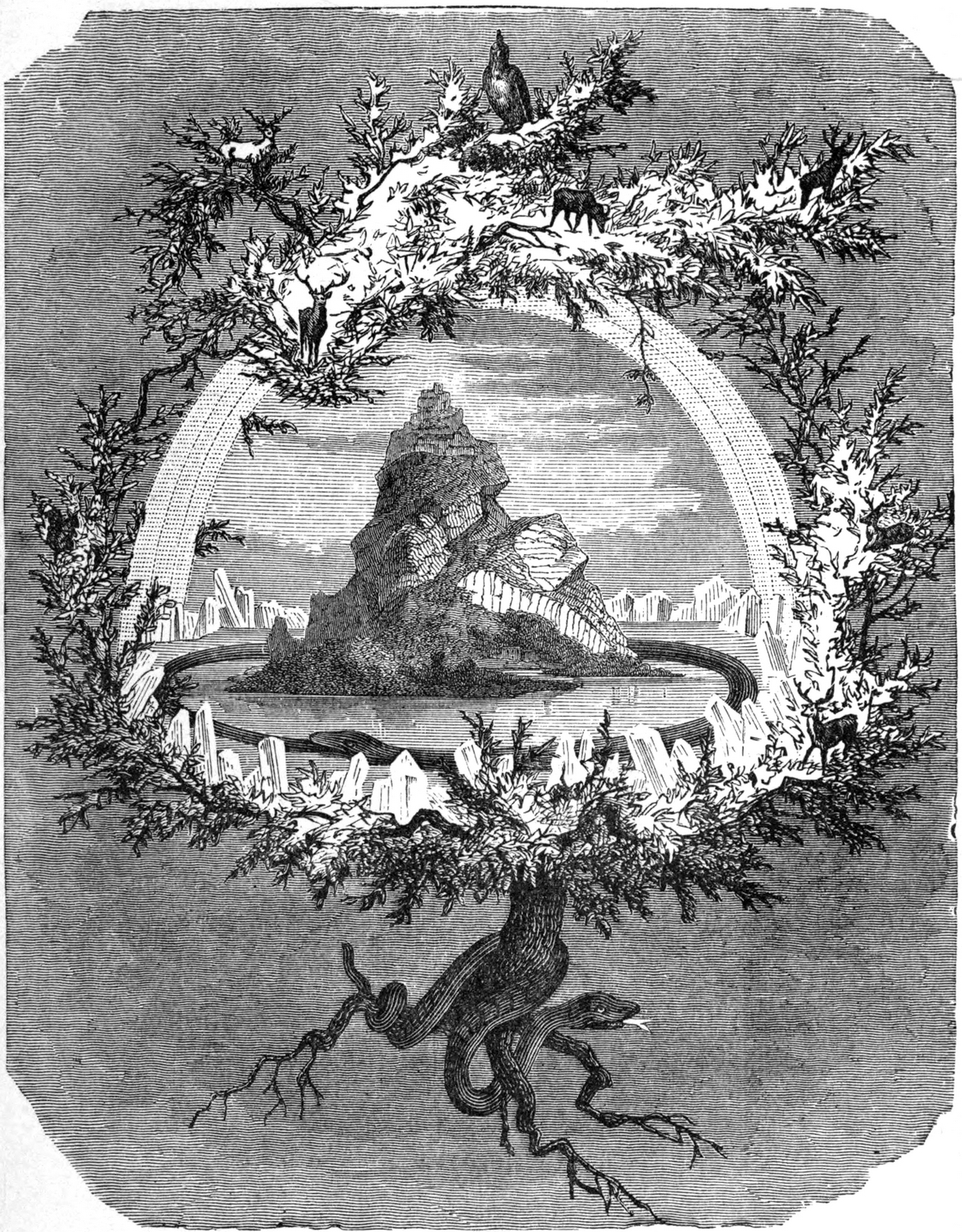
In Norse myth, the ash tree Yggdrasil was the tree of Odin and was one of the primal ingredients in their Creation myths. It stood at the centre of the cosmos: an axis mundi no less, linking the many worlds and was the abode of the gods. Its mythologies are extensive. In Scotland, the myths of the ash are not so well known, but there’s little doubt that it possessed a sanctity and certainly has many traditions of it own, which are unfortunately outside the remit of this site profile.
Crosses / Legendary Rocks (destroyed): OS Grid Reference – SE 1975 2909
Archaeology & History
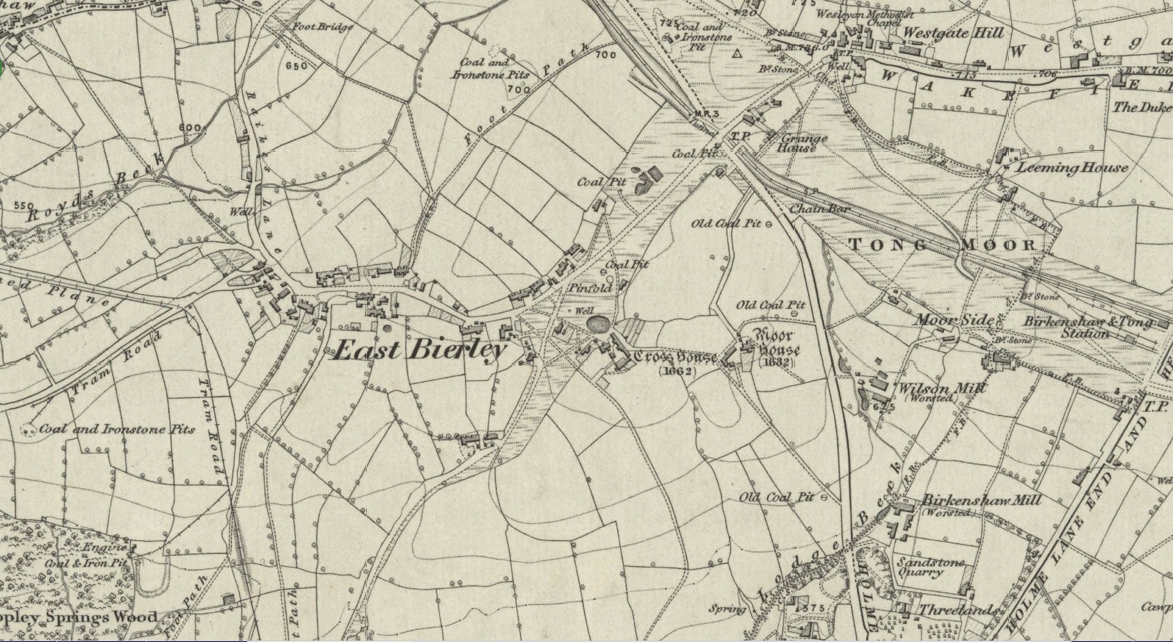
Site location at Cross House
Not to be confused with a much more renowned namesake above Ilkley, this was the name given to two old stones that once existed in the middle of the East Bierley hamlet (as it was then) southeast of Bradford. They were two large boulders next to each other, not far from the early farmstead of Cross House (see map, right) and were described in James Parker’s (1904) historic collage of the area, where he informed us that:
“On the village green (are) the primitive large stones locally called the “Cow and Calf stones,” which used to be in days gone by a Preaching Cross and Market Cross.”
When William Cudworth (1876) described the place nearly thirty years prior, he only mentioned a single cross, telling us:
“There is a lane which has long been called Kirkgate at Birkenshaw, leading up to an ancient cross on the hill. The fact of this cross being on the hill must have given rise to the name Kirk (church) gate, as there was not, until a few years ago, any church at Birkenshaw. In a previous paper we had occasion to notice the existence of the cross as an evidence of a pre-church period.”
The meaning behind the name Cow & Calf is unexplained by our respective authors, although Cudworth’s citation of “the cross as an evidence of a pre-church period” is probably not without merit here. It seems very likely that the animal names of the two large stones—akin to the Cow & Calf Rocks at Ilkley and others of the same name elsewhere in the country—that sat near the top of the hill, probably possessed a creation myth similar to others of the same name. From this, it seems logical that local folk held the rocks as important, which would have obviously attracted the regressive attention of Church—so they stuck a cross here to christianize the place and in doing so ensured that local people could continue using the place as a meeting place. This practice (as if you didn’t already know) was widespread.
Although Mr Cudworth seems to give the first real account of the place, field-name records of 1567 listed a ‘Cowrosse’, which may have been the “cross on the Cow” stone. A.H. Smith (1961) listed the site and suggested the element –rosse may derive from a local dialect word meaning a marsh, but a ‘cow’s marsh‘ seems a little odd. It is perhaps just as likely that an error was made in the writing of rosse instead of crosse.
References:
Cudworth, William, Round about Bradford, Thomas Brear: Bradford 1876.
Parker, James, Illustrated History from Hipperholme to Tong, Percy Lund: Bradford 1904.
Smith, A.H., The Place-Names of the West Riding of Yorkshire – volume 3, Cambridge University Press 1961.
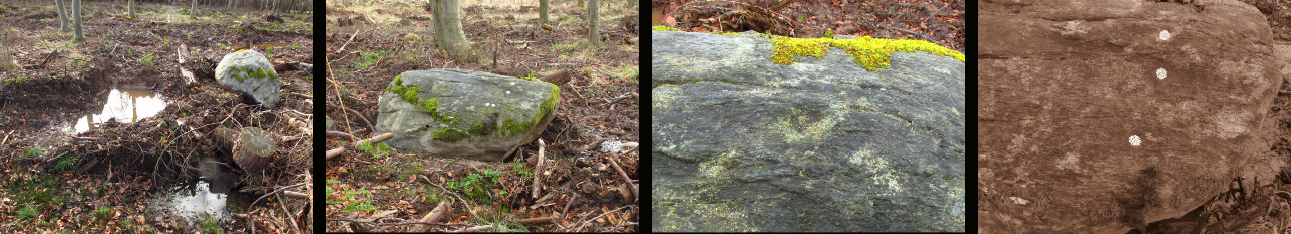
Turn right off the A93 at Cargill onto the side road by Keepers Cottage and up the hill to Gladsfield Wood at the top on your right. Park up at the top side of the Wood and walk straight along the narrow track for around 450 yards and what may be the remains of the stone will be seen between a pair of mature trees.
Archaeology & History
In 1862 the stone was described in the Ordnance Survey Name Book for Perthshire:
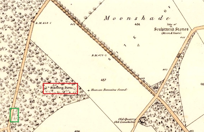
‘And about 150 yards from the same object [Hangie’s Well], in a north-westerly direction, there is a small Standing Stone, having the appearance of the ancient monumental standing stones.’
It seems the stone had been removed by the time Fred Coles (1909) came to see it nearly fifty years later. He told us:
“On the day of my visit the mist was so abnormally dense and confusing that it was with considerable difficulty the wood itself was identified; and as its interior is an utter wilderness of trees, shrubs, brambles, broom, wild roses and tall grass, besides being a pheasantry, it is just possible that the monolith searched for evaded my zeal. I think not, however, because, hearing a hedger at work on the Newbigging side of the wood, I made for him; and after plying him with various questions, could get no statement to the effect that he had, though living so near, ever seen any conspicuously tall Stone in the wood.
“On retracing my steps, I searched a fresh portion of the wood, and noticed one biggish block of whinstone lying on the grass in a slight hollow of the ground. It was somewhat cubical, about 2 feet 6 inches square, and fractured. This may he a portion of the former monolith, possibly; and with this dubious result I had to be content.”
In 1967 the archaeologist O.G.S. Crawford described “a sharp-edged boulder standing near the spot marked on the map,” but was not certain if it was the stone. It had no markings on it.
25 in OS map of 1866 showing original position of stone outlined red and position of possible remains of stone in green
Moving on to 2020, and I found the same impenetrable jungle that Coles described more than a century earlier. When a site has been destroyed I can normally take a photograph of where it once was, but not in this case. I continued westward over difficult and potentially ankle snapping terrain that had recently been replanted with conifer saplings, until I got out of the planting area to a line of mature trees next to the track through the wood.
One large elongated stone presented itself that had clearly lain there for many years judging from the moss growth, a short distance away at NO 15641 35478. Could this be the top part of the standing stone, dragged from its original position some 500 feet to the north-east? It is of grey whinstone, heavily veined at the base, with white quartz and tapering to a pointed tip. It has a squarish base measuring approximately 3 feet across by at least 2 feet deep and is some 7 feet in length. It doesn’t look to be natural, so is it a likely candidate for our missing stone? Felled by a man with a hammer and chisel and dragged by a heavy horse to the edge of the field as part of the ‘improvements’, so beloved of nineteenth century landowners…
We can’t prove it is the remains of Hangie’s Stone which may, after all, still lie buried in the boscage…
The possible remains of Hangie’s Stone
The stone in its original position was next to the Roman road from Camelon via Stirling and Muthill to Kirriemuir near to the junction of a road to Inchtuthill Roman Fort, so may have once been a way marker, although it is not of Roman origin.
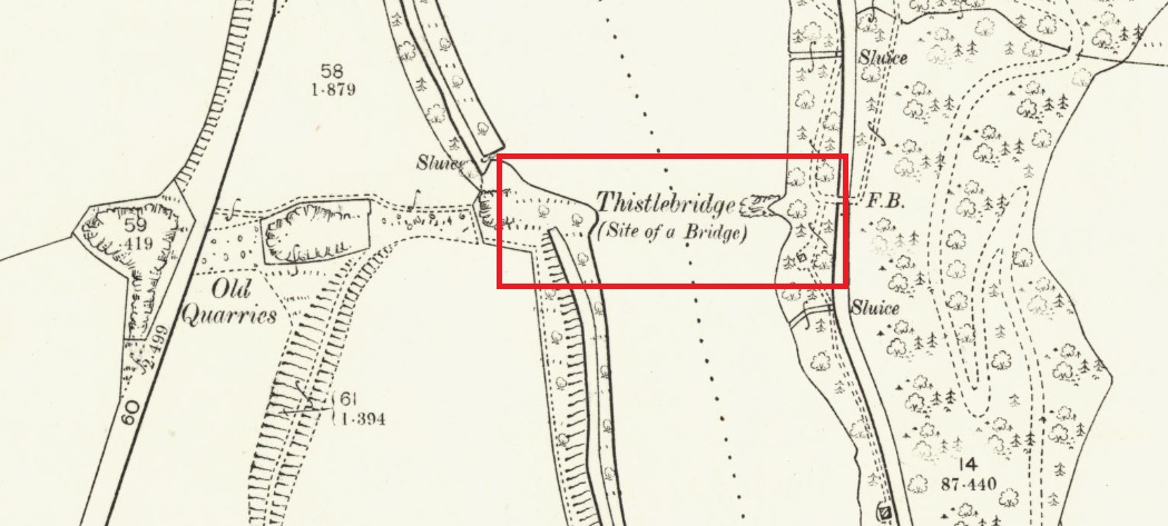
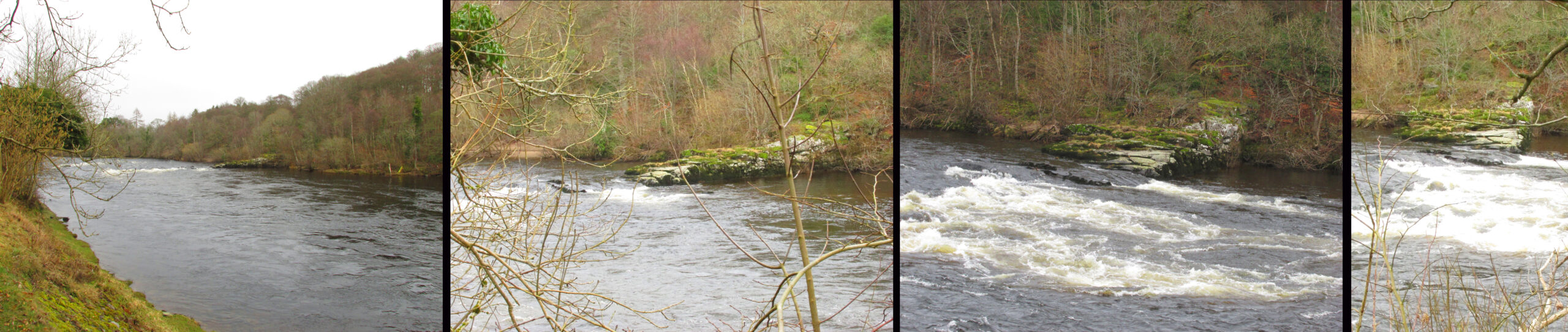
The easiest way to see the site is to stop at the car park at Craighall on the B9099 south of Stanley, and follow the path to the river. The remains of the Brig will be seen on the other side of the Tay from the riverside walk.
Archaeology & History
The Thistle Brig was described in the nineteenth century Ordnance Survey Name Book as:-
‘A remarkable spot in the River Tay, when the breadth of the river becomes suddenly narrow by the protrusion of a bed of trap rock which crosses it at this place.’
Thistle Brig & the quarries for its hard stone on the 1901 25 in OS-map
According to local historian Alexander Scott, the Thistle Brig formed a convenient place to ford the Tay until much of it was blasted away by explosives some time in the mid-nineteenth century in order to improve the flow of the river. Old maps imply that an actual bridge may have spanned the Tay hereabouts at some time in the past. The seemingly little known folklore of this site relates to an invasion by the Danes in the early mediaeval period. Elsewhere there are similar stories, so the truth or otherwise depends on where you are in Scotland, but this one may have more validity as the tale seems to give its name to the place!
The name ‘Thistle Bridge’ has been applied on old postcards to a stone footbridge over a side channel or lade between the road and the River Tay to the south of the Brig, and is not the subject of this profile.
The remains of the Thistle Brig – a hard basalt dyke on the east bank of the River Tay
Folklore
Alexander Scott, writing of the Brig:-
“…tradition holds that here the thistle received the distinction of becoming the national emblem of Scotland. In one of the many invasions the country suffered from foreign armies, the Danes, on one occasion, having landed on the east coast sacked the town of Montrose and continued on their march across the country, burning and pillaging as they went. While crossing the Tay at this ford at night, the incident occurred of one of the leading soldiers arriving on the opposite side suddenly coming in contact with a thistle with his bare leg, which caused him to emit a shreik of pain.
“The noise was heard by the Scots, who had been encamped nearby, and the alarm thus given was the means of securing a victory over their enemies. The thistle was thereafter honoured as the national badge.”
Reference:
Scott, Alexander, St Martins and Cambusmichael, A Parochial Retrospect, Munro & Scott 1911.
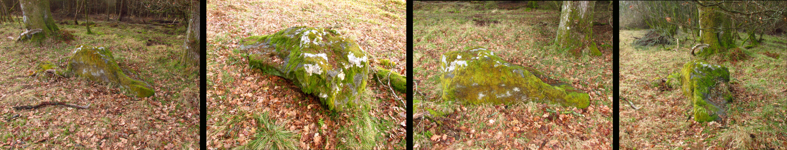
Turn right off the A93 at Cargill onto the side road at Keepers Cottage and up the hill. Gladsfield Wood is at the top of the hill on your right. Park up at the top side of the Wood and walk along the narrow track to where it crosses another track, look 45º to your right and you’ll see the stone.
Archaeology & History
One of those chance finds that turns up when you’re looking for something else. Recent forestry work had dislodged the stone from its original earthfast position of millenia, only a few feet away. It may have been rotated from its original position. The grey whinstone rock measures around 5′ 8″ (1·75 m) long, 3′ 9″ wide (1·15 m ), 2′ 9″ (0·85m) high, and the moss shows its original depth in the ground. Fortunately the cup marks weren’t damaged in what appears to have been a quite brutal move. On what is now the north east facing side there are three definite and one possible very shallow fourth cup mark. The top cup is the most prominent, while the possible fourth cup is just to the left of the bottom one.
L-R 1. The original position of the stone 2. The stone showing the possible fourth cup 3. The prominent top cup 4. The three definite cups
One for the enthusiasts really, in an area of Strathmore quite rich in megaliths and rock art; whatever the future holds for this dislodged stone in the savage world of agri-business, it is now recorded for posterity!
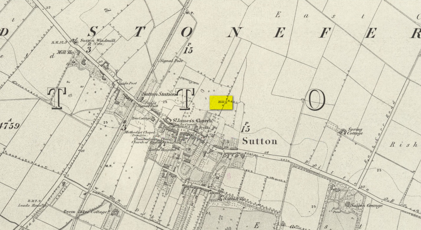
We don’t know for certain the precise whereabouts of this long lost healing well, but it would seem to be the one highlighted here (right) on the 1855 OS-map. However, I think it equally possible that the small unnamed building, roughly halfway between the highlighted ‘Well’ and Spring Cottage, where the walling meets, could be the site in question. It’s one or the other!
Folklore
When Thomas Blashill (1896) wrote of the Blind Well in his standard history work of the area, memory of it was already falling away. In discussing where local people could wash and look after their health, he told that
“There was one place in the parish where washing seems to have been practised as a curative measure. Down in the East Field, near to Spring Cottage Farm, was the Blindwell, to which the people had access. If they used its waters freely when suffering from sore eyes, their faith would probably be rewarded.”
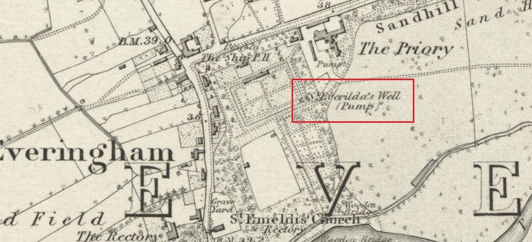
Holy Well (destroyed): OS Grid Reference – SE 80528 42531
Also Known as:
St Everildis Well
Archaeology & History
Shown on the 1855 Ordnance Survey map as a ‘pump’, in the grounds of Everingham Priory, the ‘seat’ of the lord of the manor, it was in an enclosure formerly open to the people of the village. It was filled in prior to 1923. The water was described as ‘abundant and excellent.’ Graeme Chapman, in his Yorkshire Holy Wells website states:
‘A few metres to the south of the site of the well the modern OS map marks the start of a stream (SE 8055 4250) which could be the original source of the Holy well’s water.’
The well shown on the 1855 6″ OS Map.
The present writer has not been able to verify this from the materials available to him.
Everilda, also known as Everild and Averil, is recorded in the York Breviary, printed in 1493. She was a mid Yorkshire Saint who died around 700 CE. According to this source she was of a noble Wessex family who went to Yorkshire with companions Bega and Wulfreda, settling on land called Bishop’s Farm, an estate of the Bishop of York, St Wilfrid , which he gave to them, the place being then called Everildisham. There they established a nunnery, of which all trace is now lost. Her Saint’s day is July 9th. The name of St Everilda has been changed to ‘Emeldis’ in the dedication of the church at Everingham. Some historians claim the village is not named after her, but as a derivation of ‘ham of Eofor’s people’. The only other church known to be dedicated to her is at Nether Poppleton, some 17 miles north west of Everingham.
Folklore
The water of the village and the mothers of Everingham are said to have been blessed by St Everilda, and the Reverend Smith wrote that over a fifty year period, no mother had died in childbirth.
References:
Farmer, David, The Oxford Dictionary of Saints, Oxford University Press, Oxford, 1987
Raine, James, The Dedications of the Yorkshire Churches, The Yorkshire Archaeological and Topographical Journal, Vol II, 1873
Salisbury, Matthew Cheung, The Use of York: Characteristics of the Medieval Liturgical Office in York, Borthwick Institute, York, 2008
Smith, Rev William, Ancient Springs & Streams of the East Riding of Yorkshire, A.Brown & Sons, London, Hull & York, 1923