A slight walk to get here. Follow the same directions as if you’re going to the Eller Edge 431 carving. Once here, walk west as if you’re going into the middle of the field, keeping your eyes peeled about 20 yards along for a small-ish rounded stone with nice colours of lichen amidst the grasses. If you’re patient, you’ll find it soon enough!
Archaeology & History
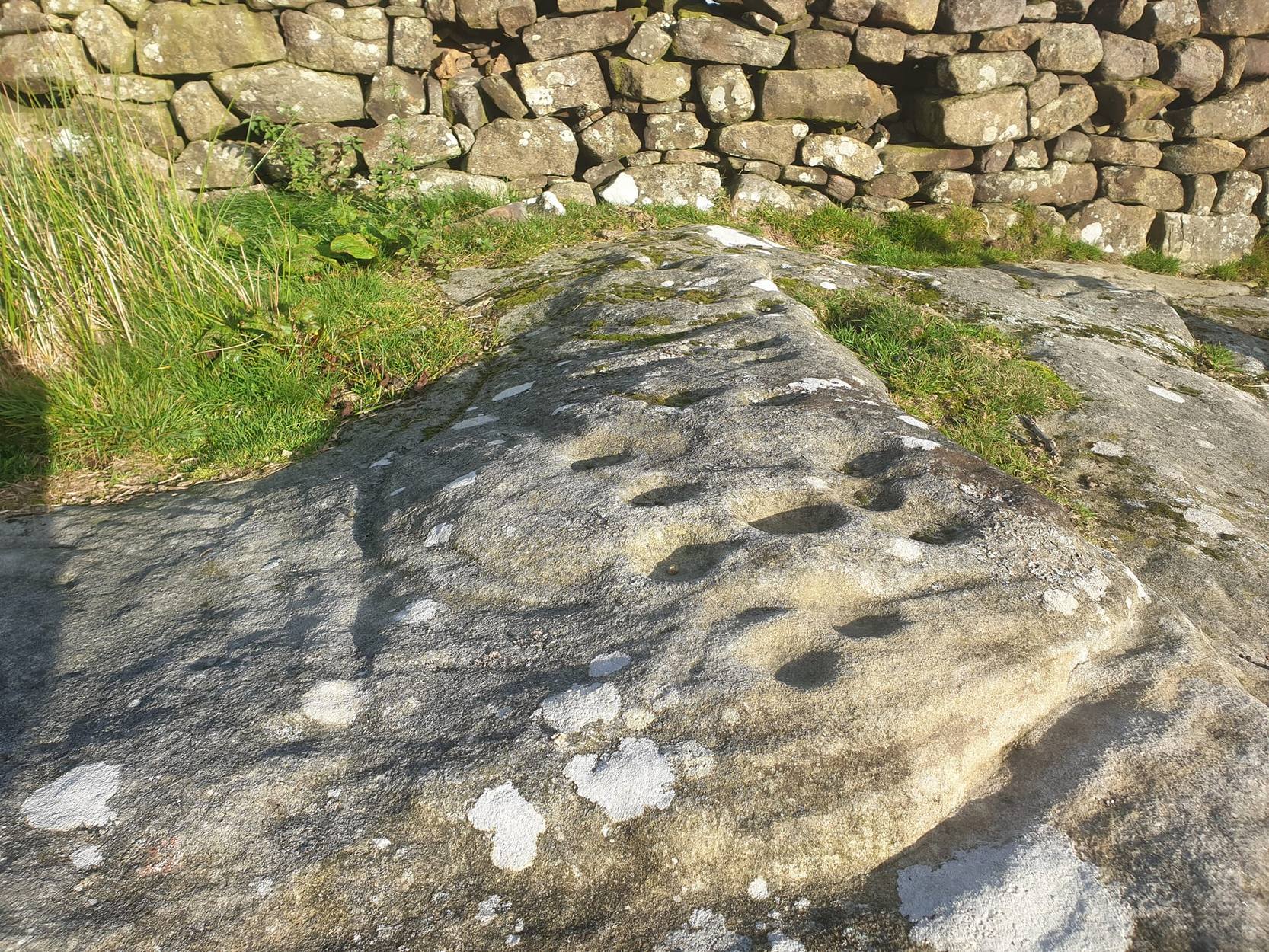
This is another simple cup-marked stone on the grassland ridge overlooking higher Wharfedale. The carving here is a little clearer and more well-defined than that of its close neighbours, with a number of simple cups visible on its rounded surface. We counted seven such cups on our cloudy-day visit, but Boughey & Vickerman (2003) thought there might be a little more, describing the stone simply:
from another angleB & V’s drawing
“Small lichen-covered rough grit rock. About eight cups and two depressions.”
A rubbing of this small stone (as practiced by English Heritage and rock art students alike) would prove useful in bringing out any other ingredients in the ancient design. And whilst you’re in this field, have a look at the curious Spiral Stone and some of the other cup-markings close by.
References:
Boughey, Keith & Vickerman, E.A., Prehistoric Rock Art of the West Riding, WYAS: Wakefield 2003.
From the road between Pateley Bridge and Summerbridge, the B6165, turn down to Glasshouses, following the road through the village and round past the reservoir; then as the road bends, keep to your left and go the steep zigzaggy hill, stopping where a gravel parking space is on the right-hand side of the road, by the bend. From here, cross the road and walk up the footpath to Yorke’s Folly. Go over the wall and along the footpath by the wall (the Nidderdale Way) for a coupla hundred yards. Then turn into the heather about 50 yards up from the walling. Look around!
Archaeology & History
Heyshaw Moor cairn no.1
There’s no previous reference to this site. It was found yesterday and is one of several such small heaps of stones (cairns) found along the flat ridge of moorland just south the hugely impressive of Guisecliff Crags on the northern edge of Heyshaw Moor. The one illustrated here is probably the best of the several we found and may be indicative of a previously undiscovered cairnfield. On a visit to the western side of the moors a few months ago we found another small cluster of similar cairns in very good condition, much like the one pictured here. It would appear to be prehistoric in nature — although the existence of an old track that ran nearly 20 yards to the west may indicate its previous use as a marker cairn. On the slopes below here (north) there are several examples of cup-and-ring stones, which tend to indicate the proximity of prehistoric graves. This cairn could well be such marker.
We also found evidence of other early human remains on this ridge and further up the moor (walling, rectangular building, possible cairn circle), but there appears to be no literary information explaining its nature. Further visits are needed here.
Same directions as the Slade 01 carving. But once you reach the upstanding stone cairn on the rocky hill, walk 220 yards (less than 200m) WSW and look around. You’re damn close! If you find the large cup-marked Slade 03 carving, walk back east about 10-20 yards and you can’t really miss it!
Archaeology & History
This is just one of at least seven previously undiscovered carvings on this section of moorland – and it’s worth looking for! The two other names we gave it — ‘owl’ and ‘sunset’ — come from the very notable design: owl thanks to it having the appearance of large owl-like eyes, and sunset as the two cup-and-rings are etched on the western edge of the rock and, when we found it yesterday, the sun was setting (albeit to the NW) and the image prompted talks of setting suns, the land of the Dead and other such worldwide indigenous religious myths (Harvey 2000) — for without recourse to such ingredients, these carvings are vacuous archaeocentric museum pieces and nothing more. And this carving at least deserves much more than mere cataloguing! The internationally renowned archaeologist, O.G.S. Crawford (1957) would have entered this carving into his ‘eye’ and ‘owl’ motif, representative of goddesses or spirit-forms, as would Gimbutas. (1989)
…and from above
But this carving is archetypal, as we can see, though would appear to have no other etched features on the stone’s surface. It is very close (if not within) the prehistoric graveyard that is plainly evident 30-40 yards south in the burnt heather and would very likely have had some mythic relationship with the dead (a symbiosis we have found in many cup-and-rings). We plan further ventures here in the coming weeks in the hope that we can unearth other prehistoric remains.
References:
Crawford, O.G.S., The Eye Goddess, Phoenix House: London 1957.
Gimbutas, Marija, The Language of the Goddess, Harper Collins: New York 1989.
Harvey, Graham (ed.), Indigenous Religions, Cassell: London 2000.
From Blubberhouses church by the crossroads, walk up the slope (south) as if you’re going to Askwith, for 100 yards or so, taking the track and footpath past the Manor House and onto the moor. Once you hit the moorland proper, take the footpath that bears left going down into heather and keep going till you hit the dead straight Roman Road path running west onto Blubberhouses Moor. Go on here for nearly a mile until you hit the stream and nearby Eagle Stone boulder. Walk upstream from here, on its eastern (right-hand) side for 100 yards, then walk up onto the level moor, scattered with rushes. Keep up here, heading towards the upright cairn open the skyline to the north. Once here, walk 80 yards (73m) WNW and you’ll note a number of flat stones embedded in the heather around you. You’re damn close!
Archaeology & History
Off-path and takes some finding and will all-but disappear when the heather grows back, so this one’s probably only for the purists amongst you. But I like it anyway! This is one of at least seven newly-discovered cup-marked stones hereby, including the nearby ‘Owl Stone’ with it’s big eyes! There are just two cup-marks on the flat surface: one an archetypal large cup 3 inches across and a half-inch deep; the other, a small faint cup less than 2 inches wide and very shallow which is easily missed if you pay little attention. On the photo here, the fainter cup is slightly above right of the centre. The carving appears to be on the far eastern edges of the Slade Cairnfield. Other undiscovered remains are likely to be found here.
A slight walk to get here, but well worth it once you arrive! From Appletreewick, take the road east through Skyreholme and up Skyreholme Bank track, bearing right at the fork in the tracks along the ancient Forest Road. Keep going and after a couple of zigzags, you’ll cross the Larnshaw Beck. Keep walking along the track until it runs wallside — and here, go straight down the field for 75 yards (best climbing over the rickety wooden bridge by the stream 50 yards back and walking up). Although there are a number of other stones hereby, you can’t really miss this.
Archaeology & History
This carved stone and its close associates rest upon the green slopes overlooking the Blands Valley and further across upper Wharfedale and the lands beyond. The majestic Simon’s Seat rises on the nearby western slope and there in the greater distance, once more reaches the sacred hill of Pendle, with whom so many other ancient sites commune within our northern lands. It’s hard to say for sure that the Witch’s Hill was of little relevance to this and other stones, but only a fool would ignore the geomancer’s notes about this constant.
The carving here doesn’t give much clues in any direct sense either. We have an almost arrowhead-shaped rock with a dozen decent cup-marks or so cut along and near its western side; but the notable curiosity here is the small circular cluster of smaller cup-marks dotted in a near circular mass near the middle of the stone.
When Danny, Paul and I came here the other week, the initial impression of this cluster was one of a primitive solar symbol etched onto the rock; but the more we looked, the more it seemed that these small cups appeared to have been arranged in a very rough spiral lay-out. Now I know that spirals are damn rare items in rock art (especially in this part of the world), but the more we looked and then subsequently checked Boughey & Vickerman’s (2003) illustration, the more evident it became. Of course the ‘spiral’ could be merely fortuitous, but I’m not so sure misself. In discussing this with our field archaeologist later, he suggested getting a rubbing of this part of the stone on his next visit.
The stone was first described by the petroglyph explorer Stuart Feather (1964) and later described by the rock art students Boughey & Vickerman (2004), simply as:
“Large, rough grit rock with face sloping SE down into grass at N. About twenty cups to W, with three grooves at N corner and group of about twenty small cups at NE.”
A very intriguing carving. And if you visit here, make sure you check out carving 424 and others in the same field.
References:
Boughey, Keith & Vickerman, E.A., Prehistoric Rock Art of the West Riding, WYAS: Wakefield 2003.
From Masham take the Fearby Road & go through the village, onwards & past Healey village and less than a mile on where the road forks, bear to the right past and go along the gorgeous little-known vale of Colsterdale. Less than 2 miles on, walk up the notable track veering to your right that goes diagonally uphill and past the bottom of West Agra farm along the wallside till you reach the gate. Thru the gate, walk immediately uphill on your right following the walling for a coupla hundred yards until you reach another gate into the field on your right. You’ll see a cluster of large boulders in the first field, which you need to walk past and look at the large boulder up against the walling in the next field. You can’t miss it!
Archaeology & History
Photo by Geoff Watson
First mentioned — albeit briefly — in Brown’s (2008) work, this large bedrock stone, covered down its eastern side by a line of drystone walling, has a good scattering of cups and lines, mainly on its central and westerly side. A cluster of them were etched onto a natural rise near the middle of the rock, which itself has a long circuitous line running around its northern and western sides, which you can just see below centre in the photo (below left). Altogether on this side of the rock surface there appears to be some 56 cup-marks plus a number of long carved grooves curling in differing directions: some of these appear to have been Nature’s handiwork that were subsequently modified by human hands. It’s an impressive-looking petroglyph.
Main rock surfaceCluster of cups – by QDanT
If we go over to the other side of the walling, we find more cup-markings. This discovery led Paul & Barbara Brown (2008) to classify the site as being two separate carved rocks — calling them 3a and 3b — thinking that the much smaller carved area on the other side of the wall, “may have originated from WAP 3a’s quarried southern section.” On this smaller section we find some 7 cup-markings with possible carved lines running off the edge of the stone and some running roughly parallel to the walling. Whatever the truth of the Browns’ assertion, this is a fine carving well worth looking at!
References:
Brown, Paul & Barbara, Prehistoric Rock Art in the Northern Dales, Tempus: Stroud 2008.
From Masham, take the Fearby Road to the village, keep going on the same road through Healey village and less than a mile on where the road forks, bear to the right past and go along the gorgeous little-known vale of Colsterdale. It’s bloody beautiful! Less than 2 miles on, walk up the notable track veering to your right that goes diagonally uphill and past the bottom of West Agra farm along the wallside till you get to the gate. Thru the gate, follow the wall immediately uphill to the right for a coupla hundred yards until you reach a gate into the field on your right. The cluster of large boulders in front of you is where you need to be!
Archaeology & History
Cluster of cups on WAP-2b (image by ‘QDanT’)
This carving is to be found on the largest of the boulders in this cluster. It’s a large scattered cluster of cup-markings and natural bowls all over the rolling surface of the rock. It was first described in the Browns’ (2008) survey, although as they have given this and one of the adjacent stones incorrect grid-references, it made it troublesome to initially work out which carving was which! But the photos here certainly lets you know which one I’m describing! In the event that I’ve got the wrong title for this one, someone lemme know and I’ll remedy the situation!
Brown (2008) describes this design as being “cups some linked by grooves, a rectangular feature and eroded cups and depressions.” We couldn’t work out any further elements on the stone, but the cloudy conditions when we were here prohibited a decent view of the surface.
References:
Brown, Paul & Barbara, Prehistoric Rock Art in the Northern Dales, Tempus: Stroud 2008.
From Masham, head westwards along the country lanes to Fearby village (passing the old cross on the green), through old Healey village (where once stood four stone circles, seemingly destroyed) and onwards to Gollinglith. From here, keep going up the winding steep lane until you’re at the top where, on the right-hand side of the road, a footpath takes you diagonally northwest over the uphill fields. When you hit the walling which leads to the woods, follow it up and, once at the corner of the trees, follow the track back eastwards along the wall edge, keeping your eyes peeled when you pass the second line of walling that runs down the slope. You’re damn close!
Archaeology & History
One of a cluster of fascinating carvings in this remote region of the upland Dales, this is perhaps the most impressive multiple-ringed carving of the group, known collectively as the West Agra Plantation group. The carving was rediscovered sometime in 2002 by Emily McIntosh and was described by Brown & Brown (2008) thus:
“This boulder measures 5.5 x 3.1 x 1.28m and has a multiringed motif 50cm in diameter linked by a number of grooves and isolated cups.”
Teddy with his rings! (after ‘QDanT’)Primary cup-and-multiple-rings (after ‘QDanT’)
But this barely does the stone justice. The main focus is on the cup with six surrounding rings, intersected by an intrusive double-line from outside the series of rings then running into the central ring itself — though not touching the focal cup at the very centre. This double line points to the southeast and is somewhat akin to a sliver of light running to or from old solar designs. It is a little bit like some aspects of the carved stones found on Ilkley’s Panorama Stones (though Ilkley’s carvings are much fainter). At the end of the intrusive double-line is a small cluster of cup-marks. There’s also another curious singular carved line running outwards from the third ring, running out of the concentric rings then heading off further down the stone. More cups and lines scatter other parts of the stone and there may be another faint line running from near the central cup all the way out of the rings close to the main ‘ray’ of lines.
Photo by Geoff Watson
A large standing stone can be seen if you walk a few hundred yards east along the side of the wall. It’s quite impressive.
Apparently the woodland in which this carving (and its associates) can be found is supposedly ‘private’ and one is supposed to contact some group calling itself Swinton Estates to set foot in the woods. Not the sort of practice we usually put up with in Yorkshire. If anyone has their contact details, please add them below in the event that anyone has need to ask ’em about going for a walk here.
References:
Brown, Paul & Barbara, Prehistoric Rock Art in the Northern Dales, Tempus: Stroud 2008.
Follow the same directions to get to Bordley’s Druid’s Altar circle. Where the little rough car-parky-bit happens to be by the cattle-grid, look up the sloping field where the wall runs up in a line and follow it up on foot. A coupla hundred yards up you’ll see a small craggy outcrop in front of you and another line of drystone walling in the corner. Just below this craggy outcrop you’ll notice a raised embankment comprising a line of small rocks running along the edge of the hill. This is the first bitta prehistoric walling that makes up a part of the settlement system. From hereon, follow y’ nose along and up the hill and look around. The settlement’s all around here!
Archaeology & History
This is quite an extensive area of prehistoric (seemingly Iron Age) enclosures on the top and around the edges of the unnamed rocky peak at the top of the large open Lantern Holes field. I’m not aware of any excavation work that may have taken place at this site, so please excuse me of any errors in the description that follows. (if anyone’s got an excavation report of the site, I’d love to read it!)
As with the many other settlements and enclosures in this region, much of it comprises of extensive stonework built up into and against the geological limestone bedrock either side of this hilltop site. Huge lines of prehistoric walling, measuring anything between one and three yards across, runs for hundreds of yards in and around this set of enclosures. We also find several distinct and well-preserved examples of old hut circles (one of which appears to have been re-used as a sheep shelter in more recent centuries) dotted around the edges and in the middle of larger sections of enclosed stone walls. This is all very impressive when you consider it was done a coupla thousand years back!
Walled enclosure on south sideWalling along SW edges
Very similar in design to the prehistoric settlement enclosures on the other (south) side of the valley at Hammond Close Pasture, above the Druid’s Altar, though more extensive. Measuring roughly 340 yards (311m) along its longer southeast-northwest axis, and nearly 280 yards (254m) from east-to-west, the uppermost parts of the site have at least seven separate large elliptical ‘enclosures’ built within the rocky enclaves, made up of typical Iron Age wall systems: a series of large upright monoliths packed up by smaller packing stones all along the length of the walling (using a system that still prevails today in drystone walling techniques on our upland moors). A couple of the photos here illustrated the walling very well and give you an idea of what to look out for if you’re out wandering the region, looking for old sites.
Although the walling we see today is barren and easy to spot, remember that in the time when people built these great structures, you wouldn’t have been able to see them, as they’d have been deliberately covered over and camouflaged with dressed earth and plants. In watching people emerging from these enclosures, you’d have got the distinct impression that they literally came out of the hill itself: a motif well-known to folklorists in relation to the origin of faerie-folk and other ‘little people.’
We need to go back up here and explore this settlement a bit more, as there’s tons more to be seen. And if anyone knows of any surveys that have already been done of this site, it’d be good to read the reports, preliminary or otherwise. A rough-camping weekend is planned on the tops at the break of Spring – so contact us if you’re into joining us for the amble. I reckon there’s gonna be other sites hidden in the landscape up here that even Arthur Raistrick missed out on!
…to be continued…
References:
Raistrick, Arthur & Holmes, Paul F., Archaeology of Malham Moor, Headley Bros: London 1961.
Follow the same directions to get to the Dumpit Hill A stone circle; but instead when you get to the point where you need to walk off-track and into the heather to get to the circle, keep walking up the dirt-track for about another 200 yards, watching diligently thereby for a reasonable sized, fallen, “standing-stone”-like character just yards into the heather on your right (on your left, there’s a U-shaped dip where the wall is). This is the northern edge of the walled enclosure. From this fallen ‘standing stone’ follow the overgrown walling along carefully into the heather along and down the slight slope. You’re now either on the very edge, or perhaps going into the middle of the enclosure. Look around!
Archaeology & History
East section of walling
There’s no previous written history of this site, discovered for the first time last week on our sojourn to the Dumpit Hill stone circles, by Michala Potts. She didn’t seem too excited by it at the time, but an amble back to what she’d found got me going! (easily done) With the help of the heather being burned away, open and exposed was a distinct line of prehistoric walling — perhaps Bronze Age, perhaps later. It’s hard to tell.
Structurally similar to the enclosure walling at Horse Close and Rough Haw, either side of Skipton, a few miles to the south, here we have about 100 yards of walling seeming to enclose the eastern side of the small hilltop, but running into the heather on its southern edge and the moorland track on its northern side, where it disappears again, leaving no trace of what one would assume would be a consistent western section.
From the grid reference for the site, the line of walling runs northwards for about 20 yards before taking a very slight shift in direction for another 20 yards. Here the walling goes to the left (west) for another 20 yards, before edging slightly northwest and back into the heather. A section of the walling is visible at each end, though we lose any accurate trace of it after a short distance in the long heather. However, at the northwestern point in the enclosure walling, a very distinct long stone about 4 feet high leans at an angle in the ling. It seems apparent that this stone at one point in the not-too-distant past stood upright, making it the tallest stone here.
Northern section of wallingFallen monolith?
What may be other features can be seen inside this enclosure section: a possible hut circle and other portions of walling were noted. However, we didn’t spend much time exploring the site in detail, so there is a high probability of other prehistoric remains in and around this enclosure awaiting discovery. The site’s proximity to the stone circles of Dumpit Hill A and Dumpit Hill B should be noted; along with what the North Yorkshire’s Historic Environment Officer, Robert White, said were “three, possibly four small circular enclosures (about 9m in diameter)” a short distance away. A further survey of the site is necessary to enable us a better picture of what we’re looking at here.