An old stone-lined burial cist could once be seen in this locale: reported in 1953 to have been “discovered in the southwest corner of a field south of Druimyeonbeg farmhouse.” When it was uncovered by the farmer, the covering capstone was missing. Any relics that may have been there were destroyed and there’s now no trace of anything.
References:
Royal Commission on the Ancient & Historical Monuments of Scotland, Argyll – Volume 1: Kintyre, Glasgow 1971.
Easy one this! Go up thru Baildon, on towards Baildon Moor over the cattle-grid. Take your first left and go up for several hundred yards past the reservoir until you reach the track on the left which takes you onto the Low Plain, Baildon Moor.
Archaeology & History
1845 plan of Cairns & Earthworks on Baildon Moor (after J.N.M. Colls)
In the year 1845, on the Low Plain on the western side of Baildon Hill, an intrepid archaeologist and historian, Mr. J.N.M. Colls, came across extensive earthworks and a number of prehistoric tombs in a very small area. Upon excavation, the ‘earthworks’ were found to be what sounds like neolithic walling running parallel to each other in a roughly north-south direction (north is the traditional direction for death). Scattered amidst these lines he found more than a dozen cairns and barrows, along with remains of “a circle, or ring.” Although the majority of what Colls wrote about has been destroyed, leaving only scanty remains of a once considerable archaeological arena, his lengthy description deserves being reprinted in full. He wrote:
“This level (the Low Plain) bears numerous traces of earthworks or other embankments running in many cases parallel with one another, at distances varying from 50 to 80 yards apart, and intersected by other works of similar construction. These earthworks can be remembered to have been from four to five feet in height; their bases nearly invariably appear to have been eight feet in diameter, composed of loose blocks of calliard, or close-grained sandstone, and earth. The greater part of the stone has been torn away to make and repair the roads of the neighbouring district; and the surface of the earth has been so nearly levelled that it is only by the scattered and disfigured remains, carefully delineated upon my plan, that any idea can be formed of their original character.
“In connection with these earthworks, and upon the north side of them, immediately above a steep fall to the next lower level (approx SE 1372 4020, Ed.), is a circle, or ring, formed originally of earthworks of precisely similar character, size and construction to those I have just described. The diameter of this ring is about fifty feet; its interior area is perfectly level; but the earthwork forming its circumference has been defaced and torn up for a considerable extent for the stone it contained. Circles of this nature have generally been termed druidical, from their presumed use as places of worship or sacrifice. I therefore opened its centre, in the hope of finding some trace of fire confirmatory of its character; and commenced clearing away a layer of peat earth, of from 10-11 inches in depth. I then found a layer of calliard boulders one-and-a-half feet in depth, the lower ones slightly burned, and resting upon a deposit of peat-ashes three inches in depth and from 2-3 feet in diameter (see Barrow No.8 in plan, Ed.). This I should have concluded to be the remains of a beacon fire, but, upon continuing the excavations, I found about three feet SSE of this deposit of ashes (at point b on the plan) a rude urn standing in an upright position, at a depth of two feet from the surface, a layer of calliard stones having been removed from above it, one of which appeared to have covered it. This urn was 12 inches in diameter and 9-10 inches in depth, of a circular or bowl shape, the upper stage of it being rudely ornamented by incised lines crossing each other at acute angles: it was filled with calcined bones (some remaining tolerably perfect), ashes and charcoal; and I selected some half-dozen of them as specimens, which Mr Keyworth, surgeon and lecturer on anatomy at York, has examined… He is of the opinion that they belonged to a very young subject, perhaps from 9-12 or 13 years of age; he thinks it possible however, that they may all have belonged to the same subject… The urn in which the were placed appears to have been rudely formed by the hand, without the assistance of a lathe; in substance about half-an-inch…it appears pretty evident that this urn has been formed of the black earth of the mountain and coal measures of which Baildon Hill is formed…
“A little to the west by south of the circle…are the almost obliterated remains of another circle (fig.9 on the plan), which I had not an opportunity of thoroughly examining; the slight traces remaining bear strong testimony of its character being similar to that of fig.8.
“Scattered over the surface of the Plain, and at irregular distances, cairns or heaps of stones, composed of bare sandstone and calliards (and not mixed with earth), frequently occur; they are generally about twenty feet in diameter and appear to have been originally 4 or 5 feet in height: these remains still require examination. In passing over them, I remarked that some of the stones of which they and the earthworks near them were constructed, had marks, or characters, but so rude that a doubt remains whether they may not have been caused by the action of the atmosphere on the softer portions of the stone.”
Urns found near Dobrudden
This final remark seems to be the very first written intimation of the cup-and-ring marked stones which can still be found amidst the grasses in the very area Mr Colls described. Sadly, much of the other remains shown in the drawing have been all but obliterated, or grown over. However, the decent concentration of cup-and-ring stones in this small area (see other Baildon Moor entries), highlights once again an associated prevalence of these carvings with our ancestor’s notions of death.
Sadly, year by year, the important neolithic and Bronze Age english heritage remains across this upland ridge are slowly being destroyed. The lack of attention and concern by regional archaeologists and local councillors, and the gradual encroachment of human erosion are the primary causative factors. Hopefully there are some sincere archaeologists in the West Yorkshire region who will have the strength to correctly address this issue. Under previous archaeological administrators, Bradford Council have allowed for the complete destruction of giant tombs, stone circles and other important prehistoric remains in their region—a habit that seems not to be curtailed as they maintain a program of footpath “improvements” on local moors without any hands-on assessment of the archaeology on the ground.
…to be continued…
References:
Baildon, W. Paley, Baildon and the Baildons – volume 1, St. Catherine Press: Adelphi 1913.
Barnes, Bernard, Man and the Changing Landscape, Eaton Press: Wallasey 1982.
Colls, J.N.M., ‘Letter upon some Early Remains Discovered in Yorkshire,’ in Archaeologia, volume 31, 1846.
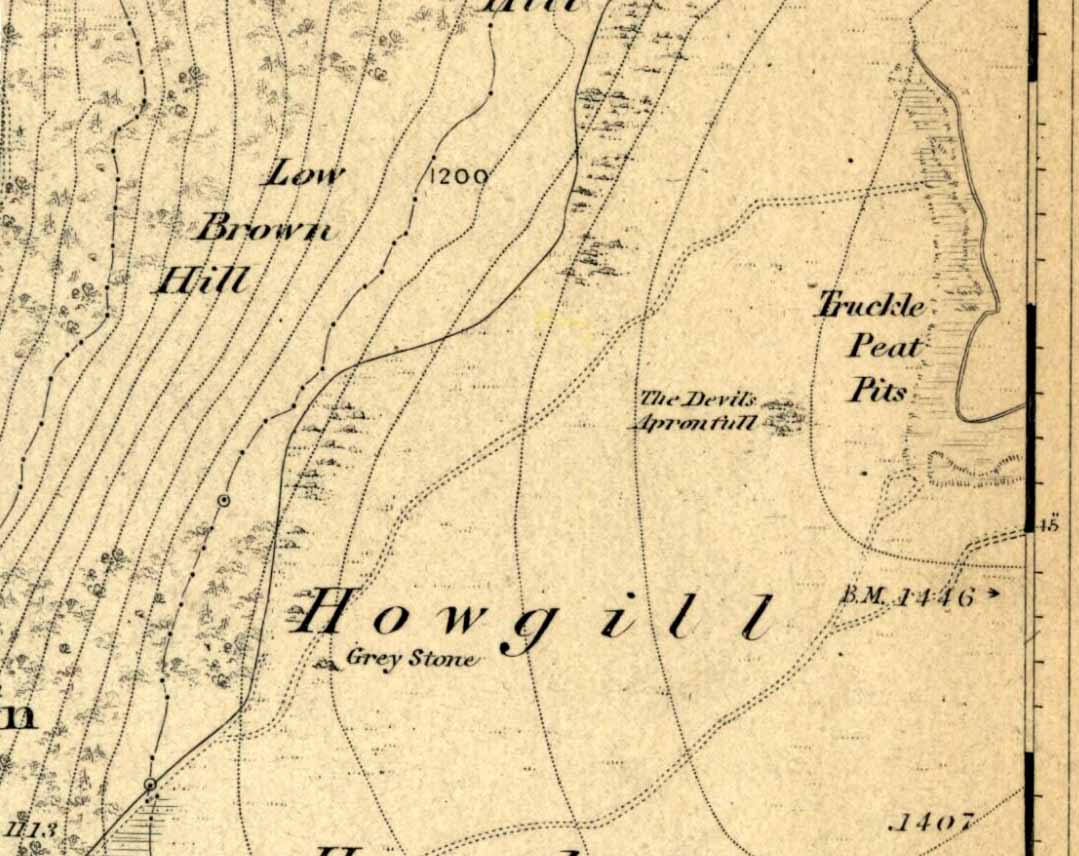
An excellent spot with fantastic views. There’s many ways to approach the place, but a good one is from the roadside by Howgill, then following the track uphill until you reach the moor, then head towards the spectacular and legendary, Simon’s Seat (which folklore ascribes to be named after the great druid, Simon Magus). You’ll pass an old Grey Stone (two large rocks) from which you can espy the old tomb if you stand on top of ’em. Keep walking uphill and it’s about 100 yards off the footpath to your right. A large boulder is nestled just beneath the tomb itself, which stands out on a ridge.
Archaeology & History
When Harry Speight visited here (1900) he described it as being 40 yards in circumference. He also described “an upright stone below the cairn” with apparent cup-markings on the west-side. I’m not quite sure where this has got to – but the site has shrunk somewhat since Speight’s day. It’s only about 20 feet across now, and the middle of it has been hollowed into a grouse-shooting butt for the toffs!
About 100 yards southeast (towards the Truckle Stones) are the remains of some neolithic walling in a straight line.
Folklore
One of many old tombs in our northern hills said to have been created by the devil who, as usual, accidentally dropped some stones he was carrying. The old folklorist Thomas Parkinson (1888) said the following of this place:
“The Apronful of Stones is a group of rocks heaped together in delightful confusion, their disorder and name being thus explained: Once upon a time—whether when he built the bridge over the valley, or at some other time, the record saith not—the Devil was determined to fill up the ravine, or gill, of the Dibble. For this purpose he was carrying these enormous crags in his apron, when, too intent upon his object to properly observe where he placed his feet, he caught with one foot upon the top of Nursa Knott, and, stumbling, the strings of the apron broke, and the contents were thrown upon the ground as they now appear. It is also said of them that if any of them, even now, were to be removed, they would certainly be brought back to their original place during the succeeding night.”
Another legend tells that the Devil’s Apronful is also the grave of some local unnamed hero.
References:
Parkinson, Thomas, Yorkshire Legends and Traditions – volume 1, Elliott Stock: London 1888.
Speight, Harry, Upper Wharfedale, Elliott Stock: London 1900.
Best approached from Haworth and then walking along the Bronte Way footpath onto the moors (ask at the local Tourist Info if you aint sure). A few hundred yards along, cross the ‘Bronte Bridge’ and keep following the footpath up until you get past the trees and get onto the moors. Once on the heathland, a few hundred yards along keep your eyes to the right and at least one of the two stones here will appear!
Archaeology & History
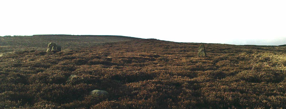
The original Cuckoo Stone
This is a fascinating little site that has been mentioned in a few old local history guides, including John Lock’s Guide to Haworth (c.1965). First described in 1852 and only briefly noted in passing by Horsfall Turner (1879), the place was previously thought to have comprised just one standing stone, but in recent years explorations by Mark Davey and I found there to be two standing stones close to each other. They are not marked on any maps and are unknown even to many local people. However, the place once had a bit of a reputation (see folklore) and seemed to be well known in the region when the cult of the Church was at its height!
Both of the stones are between three and four feet tall, but the westernmost of the two was probably much taller in bygone days – that’s because the top of the stone was vandalised in centuries past, presumably by some christians if the folktale is anything to go by! On the north-facing side of the western stone is the faint carved outline of an old cross, first described by local historians in the 1960s. It’s faint, but you can work it out if your eyes work properly! The newly-recovered (July 2005) easternmost stone is in two sections, with the very top of it having been hacked off in centuries gone by, as seen in the photos.
The second Cuckoo Stone, resurrected!
When we unearthed the previously unknown Cuckoo Stone (which was laid in the earth and covered with heather and peat), a small deposit of quartz crystals was found in the original socket beneath it when we came to stand the stone back in position. Question is: who put the quartz there? The original builders, or the nutters who knocked it down? And then we might ask: what was the reason behind placing a large handful of quartz beneath the standing stone?
In the heather beyond, about thirty yards to the north, we also find what looks like the remains of an old prehistoric tomb. If we make sense of the Cuckoo Stone’s folklore, we can safely assert that these monoliths were the spirit-home of the old dood/s buried in the tomb behind…
Tis a lovely little place…
There’s also something from that strange electromagnetic-anomaly region attached to this site, well-known to students exploring the physics of megalithic sites. When my lovely friend Mark – “grope me baby! grope me!” – Davey and I rediscovered the second Cuckoo Stone, Mark brought with him a device that measures fluctuations in electromagnetic radiation. The readings taken were fine just about everywhere (background, with minor fluctuations), apart from two very curious straight lines which ran either side of the burial mound down towards the two Cuckoo Stones, with radiation readings being between 10 and more than 60 times above background! The highest readings came from those closest to the burial mound, with levels dropping as we approached the standing stones. Such magnetic anomalies have been found at a number of megalithic sites in the UK, as described in Paul Devereux’s Place of Power (1989) and other books. But the fact that the anomaly lines here seemed to run in lines would be something that those ley enthusiasts would no doubt be intrigued by!
Folklore
The creation myth of this site tells that once, long ago, a great giant lived upon these old moors. He wasn’t a good giant though, from all acounts: robbing and persecuting those who would venture onto the hills hereabouts. The local people wouldn’t dare venture onto the moors and they long sought for a hero who’d be able to sort him out! This eventually happened and in a great fight, our unnamed hero caught and killed the old giant. But just as the giant was about to die, he used his ancient magick powers and, “with a magical groan, he did transform before them and became the Cuckoo Stone.”
But that wasn’t the end of the matter because, as our unnamed hero realised, knowing that the head was the seat of the soul, even in his petrified stoney state the giant may one day recover his life, and so he chopped off the top of the Cuckoo Stone and rolled it into the valley below, dismembering the ‘head’ from the giant, seemingly forever…
It is said that the winnings of this old giant, stolen from his countless victims, are hidden somewhere high upon these hills, awaiting the shovel of some fortunate treasure hunter!
The motif of this tale is universal and archaic, echoing traditional or aboriginal lore from elsewhere in the world. The tale is a simple one: originally the ‘giant’ was a local hero, chief or medicine man who lived on these hills and the Cuckoo Stones his petrified body, and with the incoming christian cult, the giant became demonised. It seems that the ingredient of the giant’s death may infer a burial of sorts and, a hundred yards behind the Cuckoo Stones (both of whom have had their ‘heads’ hacked off), is a mound of earth which, when seen after all the heather’s been burnt away, has all the hallmarks of a prehistoric tomb (it is seen in the top photo above, as the mound in the background behind the standing stones).
In Thomas Pennant’s A Tour in Scotland and Journey to the Hebrides, 1772 (1790:226), he described there being three prehistoric cairns about four-hundred yards west of Ardminish, or a couple or hundred yards north of the Achamore Standing Stone, on Cnoc na Croise, but they seem to have been destroyed. At least two of them were between 4 and 5 yards across and contained cists. A search for the site by the Royal Commission lads in the 1960s found nothing—although they may have been looking in the wrong place (the grid reference given above is an approximation). Does anyone know anything more about these seemingly lost sites?
References:
Royal Commission for Ancient & Historical Monuments of Scotland, Argyll – volume 1: Kintyre, HMSO 1971.
Also known as the ‘Stones of Islay,’ these two old stones can be found on the west side of the road between Port Ellen and Ardtalla, up the steepish wood-covered slope, just south of the conical fairy hill of Cnoc Rhaonastil.
Archaeology & History
In recent years, the Scottish Royal Commission commented that “they do not appear to be of prehistoric date,” yet include it in the Argyll survey (vol.5:65), just in case! The larger of the two monoliths is nearly 6 feet long (it was on the floor when I came here, many years back), and its smaller companion about 3 feet long (also on the deck!).
Folklore
In 1794, in the Statistical Account of Scotland, it was said that these two curious standing stones marked the grave of Yla or Yula, “a daughter of one of the kings of Denmark,” which is most unlikely. Between these two stones, folklore tells, is known as the Tomb of Yla – a Danish princess whom legend tells gave Islay its name.
The hill above these old stones was long known to be the place of the faerie-folk. Indeed, the Queen of Faerie herself lived here. Otta Swire told a fascinating old folktale of this place, whose nature will be know to some:
“The Queen was much troubled by the stupidity of human women, for in the fairy world wisdom is chiefly possessed by the women, since it is they who hold the Cup. After much thought, She decided to try to improve matters, so she sent out an invitation to all the women of the world to visit Her in Her hall in the knoll on a certain date. The invitation spread over the wide Earth – it was carried by the winds and the sea waves, by birds and by fish, even the leaves of the trees whispered it. And the women of the world were very much interested and they talked eagerly together. Some laughed at it, some said they were wiser by far than the Little People, some held that the Little People were cleverer and more powerful than they and that this might be a trap. Indeed, the word of women ‘heaved like hive of bee or hill of ant or byke of wasp.’ Soon, women from all over the isles began to arrive in Islay. Some came to see, many more to be seen, and a few came truly seeking wisdom.
“When the day dawned the hill opened, and into the wonderful hall within streamed the women. And a very wonderful hall it was, hung with bright cloths woven from nettles and fairy lint and dyed with blood of shell-fish and sap of plants in such colours as only the Little People can achieve. Skins of beasts were spread on floors and seats, a banquet set on shells of pearl lay ready on the many tables of wood and stone, and for each guest there was placed ready a beautiful cup formed from a blue-eyed limpet’s shell. A soft green light pervaded the hall. When all were ready and the watchers saw no more coracles on the waters or maidens climbing the green slope, the doors to the outer world were closed and in walked the Queen Herself. She was smaller than any of Her guests but far, far more impressive. She wore a dress of long ago but it suited well Her gentle, kindly dignity and Her face shone with a strange and lovely light. She carried in Her two hands a wonderful flagon and after her came her maids, each holding a similar one. Other maids hastily distributed the cups of shell and then the Queen walked slowly by, pouring into the cup of each of those who, in her heart truly desired wisdom, a few drops of the precious fluid from Her flagon, which held the distilled wisdom of the world throughout the ages. And as each woman drank those few drops she suddenly grew wise and saw and understood much she had never known before. Some were able to see much, others but a little, yet all benefited in their degree. At last, all who sought wisdom had received it and the elixir was finished. Just as the ceremony ended there came a hammering on the walls and the doors. The Little People looked out and, behold!, their hill was covered with late-comers who had arrived after the doors were closed and so had been unable to enter and were now too late to receive the gift. There is still a saying in Gaelic about a stupid woman: ‘She was out on the knoll when wisdom was distributed.'”
A saying I remember my old grandad telling a few folk a few times when I was young!
References:
Royal Commission on the Ancient & Historical Monuments of Scotland, Argyll – volume 5: Islay, Jura, Colonsay and Oronsay, HMSO: Edinburgh 1984.
Swire, O.F., The Inner Hebrides and their Legends, Collins: London & Glasgow 1964.
Sadly this site can no longer be seen, but it was evidently something worth seeing in its day. Twas found “on the north side of Loch Laich, opposite Castle Stalker.”
Archaeology & History
In 1758 W. Burrell wrote about “a very large circular heap of stones, called Cairnbane, in which are said to be several subterraneous apartments, the passages leading to them, supported by large beams of timber in some places, in others by large stones, the entrance is now closed with a stone.” But in 1760 Richard Pococke reported that he could enter the cairn, saying that,
“on the west side of it a little way up is a very difficult entrance which leads to a cell about two yards long and one and a half broad, a this by a sort of door place to another about the same dimensions. I observed in some parts the stones on the side are laid flat, in others edge way, and a little sloping, and large stones are laid across on the top; To the north of it is a low heap of stones, in which three mouths of entrances are very visible, and there seemed to be two more; …the large one is twelve yards long at the top and about a yard broad: It is not improbable that these cells were built all round and several stories of them one over another.”
Explorations here by A.S. Henshall and the Royal Commission for Historic Scotland were unable to find the site and it has been deemed missing or destroyed. I have yet to seek out any folklore relating to this lost site, but would be very surprised if there wasn’t something loitering in some of the old tongues and tomes!
References:
Royal Commission on the Ancient & Historical Monuments of Scotland, Argyll – volume 2: Lorn, HMSO: Edinburgh 1975.
Best way to get up here is to start from the old hall and haunted bridge at Wycoller. From here walk upstream, on the footpath on the south side. It wibbles about following the waters for a half-mile until the moors open up when you reach an old stile, past which is another bridge over the stream. Walk past this (keep on the same side) for another 50 yards, then walk up the hillside where, if the vegetation is low, you can just see a decent-sized collection of rocks. This is the old cairn.
Archaeology & History
I don’t think the site is in the Lancashire archaeological register, but it’s described in John Bentley’s fine local history work, Portrait of Wycoller from 1975. He told that,
“a suspected Bronze Age burial mound at Brink Ends in Wycoller was excavated by Stanley Cookson in 1971 and 1972. Although no interment was discovered, the remains of a fire was found in the centre of the mound with half-burnt twigs and coal.”
Brink Ends Cairn, Wycoller
It’s not unlike some of the giant cairns on Ilkley Moor and elsewhere, though not as big, nor as high, being only about 22-24 feet across. Some of the stones have evidently been taken for use in the local walling, and the ‘cairn’ is in a pretty abject state. It’s a bittova odd spot to be honest. Not 100% sure what to make of it – though flints, arrowheads and similar implements have been found on the moors here close by. Bentley (1975) also told how “Stanley Cookson had strong suspicions that an Iron Age settlement existed in this area, but only time and further exploration will tell.” A sentiment I tend to agree with. And on our first and only visit here — during one helluvan awesome downpour all day — what seemed like an Iron Age hut circle was noted a few hundred yards to the south; though we got so saturated that day that we decided to turn for home soon after looking at this cairn.
Cookson and Hindle (1985) later described this site as a “middle Bronze Age burial cairn of 1400 to 900 BC, adding:
“The 34ft diameter inner circle was excavated during 1956-58 disclosing flints, a hearth with an abundance of charcoal, and four pieces of coal on a round, heavily burnt stone.”
More visits to these moors to check for other archaeological sites are needed in the near future to see what else might be on these unexplored moors.
References:
Bentley, John, Portrait of Wycoller, Nelson Local History Society 1975.
Cookson, Stanley & Hindle, Herbert, Wycoller Country Park, H.Hindle: Colne 1985.
Start at the Nick of Pendle and walk up the footpath towards the denuded Apronful of Stones’ cairn. Keep going up the hill for another 300 yards or so, just past where there’s a path that turns-off towards the ritual Deer Stones. As you walk upwards, in front of you you’ll see the tell-tale sign of many small stones scattered in their tell-tale manner, rising up at the edge of the footpath. This is it!
Archaeology & History
This was the third in a group of previously unrecognized giant cairns that I found in August 2006 (it certainly wasn’t in the archaeology records anyway), all on the south side of our legendary Pendle Hill — and it’s bloody huge! However, unlike the other two (the Devil’s Apronful and the Lower Apronful of Stones, further down the slopes), this one doesn’t seem as certain as the other two, but it’s still worth including here and cannot be discounted until a decent archaeological assessment has been made.
Looking up to the height of the Badger Wells CairnSection of the surface remains, showing thousands of stones
Just like its companion cairns, although it’s covered over with much soil and grasses, all round the edges are hundreds of small stones and rocks, of the same type and size as the other two a bit further down the hill, and similar to the Skirtful of Stones on Ilkley and elsewhere. The overgrown heap of stones here stands about ten-feet tall from the lower western edge and measures approximately 28 yards (north-south) by 20 yards (east-west).
Although this cairn is named after the nearby Badger Wells — which gets its name either from the local badger population, or else the old ‘badger-men’ who used to trade hereby — another fresh water source also emerges near the bottom of its western side.
Upon asking a couple of passers-by (they were local regular walkers up this great hill) about this and the other giant overgrown cairns upon this hill, they didn’t have a clue they existed — although they did suggest we contact the Lord of Downham on the north side of the hill. And so there we ventured, in search of the Great Stone – and guess who we bumped into…?
Paul, Danny and I came here via the Feizor village route, zigzagging about, to and fro, seeing the other old sites in the region; but the easier direct way to get here would be from Settle. Walking through Settle, going out of the top end of town, cross the old bridge and take the country-lane on the right, up northwards towards Stackhouse. A mile along the road (shortly before Stackhouse), a footpath on your left veers up diagonally through a small copse of woods. Go up here and out the other side of the trees, the path turns left and up over the fields. Go up here, and over the third wall along the footpath, you’ll see a large overgrown pile of rocks 30 yards in front of you with a large stone laid roughly in its middle. You’re here!
Archaeology & History
This is an excellent though much neglected prehistoric cairn of some considerable proportions, its rocky mass laying half-covered in deep earth and grasses, yet with still a very large section of it open to the elements. The creature is nearly 30 yards across and some 4 yards high — though it’s hard to say with any certainty, where exactly the natural Earth begins and the cairn starts. But from whichever way you look at this large cairn, walking around the overgrown features, you know it’s a big thing — similar in size and nature to the Great Skirtful of Stones on Burley Moor, and the neolithic cairn on Bradley Moor, near Skipton.
Paul & Danny atop o’ t’ pileBear’s photo, looking SW
On the modern OS-map there are 2 ancient cairns marked close to each other — and our “Apronful of Stones” is the lower one of the two.
In recent years the site was described briefly in Dixon’s (1991) Journey through Brigantia, but there’s been very little written about the place in modern archaeological surveys. The first account I’ve found of the site was written by an anonymous “W.F.” in The Gentleman’s Magazine of 1784. In a detailed lengthy essay, the following words were penned:
“This barrow, or tumulus, stands in an elevated situation, upon a mountain, above the hamlet of Stackhouse, and may be discerned at a great distance…
“The form of this vast mass is circular, or rather orbicular ; the height, by computation on the spot, about 9 or 10 feet. It is composed of an incredible quantity of stones, piled in such a manner as to rest upon each other’s basis, and strengthened by its conic form, it rises upwards in this curious shape. Those stones that form the outside of the work are so small that a soldier could carry them; and since it has been argued that such a monstrous work as this would not be attempted by any nation, but was natural, the largeness of the tumulus may easily be accounted for, since they were annually increased out of reverence…
“This barrow had been opened many years ago, and it is represented in the plate in the state in which it has appeared till lately. Some old people in the neighbourhood remember its being entirely complete, and having a very flat top. It was usual, in finishing these works, to lay a flat stone at the top. The people that opened it left their intention unfinished, only throwing down the lid of the stone coffer, and one or two of the sides; and, meeting with nothing worth digging for, they left it. Upon examining it in this state, before its being entirely disfigured in the last attempt, I found several human bones scattered up and down therein, amongst which I selected the patelae of the knee, the vertebrae of the spine, part of the jaw, and several teeth.
“Round the area is a wall or rampart, of the same materials as the outside, its height from the interior part about 2 feet, irregularly ranged with fissured remnants. In the centre of the cavity or area is the above chest, consisting of several huge stones of vast magnitude and density, fixed firmly into the ground, which supported a lid of equal size, though it is now thrown off the top. In this chest are partitions, for what purpose is not known, unless each space was allotted to its particular relique or body. In the partitions and sides of the coffin is a kind of hole in the edge, with a rude mould. (my italics, PB) Not many weeks ago, the curiosity of some of the neighbourhood was excited to investigate this stupendous work of art, and accordingly labourers were hired, when, upon searching a day (yet not half the work done), a human skeleton was found, in due proportion, and in a fine state of preservation, excepting the skull and one of the limbs, which were moved out of their place by the workmen’s tools. A small circular piece of ivory, and the tusk of an unknown beast, supposed to be of the hog genus, was also found ; but no ashes, urns, coins, or instruments were discovered. ”
Many years later the giant cairn was described briefly in William Howson’s (1850) early survey of the district, when he told that,
“Near a gate on the path, where the descent is commenced to Stackhouse, there’s a cairn of eighty feet in diameter; it has not been completely examined, but human bones are commonly found in it.”
But it was more than a century after “W.F.’s” initial essay before another detailed appraisal of the place was given — and that was after a visit here by the legendary Harry Speight (1892) in the latter half of the 19th century. Along with mentioning a number of other prehistoric tombs upon this ridge, Mr Speight told:
“From Settle Bridge you may take the field-path…or the rustic lane to Stackhouse, and where the road divides just beyond Mr Priestley’s pretty house you wind beneath the wood behind Scale House to a gate and stile on the left. Here ascend the field between two large trees, and at the top go over a stile, whence a path leads up the field a good half-mile to a gate which opens into what our remote Celtic ancestors would have reverentially called the ‘Field of the Dead,’ for within this enclosure are traces and remains of human graves which carry us back to the far dim ages of unwritten history. Following the grassy cart-road a short distance you will see on the left a large circular mound thrown up about 30 feet on the south side, and about 10 feet on the north or higher side. There are other mounds of similar and smaller dimensions within the same area, some of which have been examined, but others do not appear to have been disturbed. Many of the barrows or ‘raises’, have at some time or other been carelessly dug into in the hope of finding valuables, and as doubtless in most cases nothing was found but rude chests or coffins, containing bones, these were tossed aside and no record of them deemed worthy of preservation…
“The largest of these existing raises has happily been described by a writer who signs himself ‘W.F.’ in the ‘Gentleman’s Magazine’ for 1784 and 1785. Although his account fills several pages, it is obviously defective in many particulars. We are told that the circumference of the base of the mound is 210 feet, and that its height is 9 or 10 yards, and that the casing is composed of stones “so small that a soldier could carry them,” while the inside is made up of earth and stones, some of the latter being “much larger than the external coating.” In form it was circular…and the diameter of the summit was 45 feet. The barrow he tells us was opened many years ago, but some old people in the neighbourhood remember it being entirely complete, and having a very flat top.
“…Upon examining it in its former state the writer discovered several human bones scattered about the rock and soil, among them the palletae of the knee, the vertebrae of the spine, part of the jaw and several teeth. In the centre of the mound was a cavity containing a chest composed of four upright stones and a lid 6 feet 9 inches long and 3 feet broad. The chest was in partitions, in the edges of which were a kind of hole with a rude mould. The writer, under date, Settle, Nov 23rd 1784, next informs us that, “not many weeks ago the curiosity of some of the neighbourhood was excited to investigate this stupendous work of art, and accordingly labourers were hired, when upon searching a day (yet not half the work done) a human skeleton was found, in due proportion, and in a fine state of preservation, excepting the skull and one of the limbs, which were moved out of their place by the workmen’s tools. A small circular piece of ivory, and the tusk of an unknown beast, supposed to be of the hog genus, were also found; but no ashes, urns, coins, or instruments were discovered.”
Other important prehistoric monuments can be found on the grassy limestone plain beyond the Apronful: these include the fascinating Sheep Scar Enclosure just 180 yards (165m) to the north; an associated prehistoric cairn (one of several) 57 yards further northeast; and a delightful, though overgrown cairn circle 325 yards NNW. Other Iron Age and Bronze Age remains can be found elsewhere within this arena. Archaeologists could do themselves a big favour by exploring this landscape more efficiently than they’ve done so far as other unrecognized sites exist in this area.
Folklore
Big stone in t’ middle
Harry Speight (1892) told us how the place got its name “from a tradition…that his Satanic Majesty, in haste to complete the bridge bearing his evil name near Kirkby Lonsdale, tripped and his apron-string broke which let drop this immense heap.”
Another tradition narrated again by our anonymous ‘W.F.’ in the Gentleman’s Magazine(1785) said how this giant tomb, “was raised over the body of some of the Danes slain in the general massacre of that nation.” He also told, “Such a conspicuous work must certainly be erected to the manes of some chiefs, though there is no ground to support its tradition.”
References:
Dixon, John & Phillip, Journeys through Brigantia – volume 4: Beyond the Hill of Winds – Walks in Upper Ribblesdale, the Three Peaks & Upper Wharfedale, Aussteiger: Barnoldswick 1991.
Ferrand, William, “Stackhouse, Yorkshire,” in The Gentleman’s Magazine (London 1784).
Howson, William, An Illustrated Guide to the Curiosities of Craven, Wildman: Settle 1850.
Speight, Harry, The Craven and Northwest Yorkshire Highlands, Elliott Stock: London 1892.