Stone Circle (destroyed): OS Grid Reference – NX 7079 5018
Archaeology & History
This stone circle was destroyed sometime in the early 1780s by some moron who cared little for our ancient sites. Its destruction was described by Robert Muter in 1794—the earliest known reference to the site—when he told:
“Near the Roman camp there is a Druidical temple, which was destroyed within these eight years, by the hands of an ignorant Goth, who carried off the stones, split them, and applied them to build a contemptible bridge over an insignificant rivulet, called Buckland Burn. The stones were seven in number, of round granite, and of unequal sizes. The smallest at least three feet in diameter.”
In the 1850s, when the Ordnance Survey lads came this way to map and seek out the place-names of the area, the ‘Clownstane’ was one such place they listed. In seeking an explanation of the word, a local man told them the folk memory from seventy years prior:
“Mr. Bell of Balgreddan says the name Clownstane originated from the Stones of a Druid Circle which stood convenient to this place and which was broken up and removed to build a bridge near by.”
Fred Coles (1895) included the site in his survey of the Kirkcudbright circles, simply reiterating how,
“According to Dr Muter, the stones “were seized by some vandal for the building of Buckland Bridge.””
Stone Circle (destroyed): OS Grid Reference – NX 691 447
Archaeology & History
In an area littered with neolithic and Bronze Age remains, the great Fred Coles (1895) reported a stone circle that was destroyed sometime roughly between 1890 and 1911. When he visited the place with his colleague, Mr E.A. Hornel in 1887, the megalithic ring had already been tampered with. It was, he said,
“found to consist of five granite boulders, all of them large, in situ, and the ridgy grassy hollows of five others—removed, no one can say when. In the centre of this nearly true circle, 90 feet in diameter, is a slight mound, possibly artificial.”
In 1911, when the Royal Commission lads visited the area, they could find no stone circle and reported how “no information could be obtained concerning it” from the local farmer. This might have been because he destroyed it. Some land-owners do such things, as we know; but in this case we may never know.
The site was listed without comment in the Master’s magnum opus (Burl 2000), but he gave it the “uncertain status” category; whilst John Barnatt (1989) questioned whether this was a destroyed stone circle or merely a natural setting that Cole had misinterpreted.
References:
Barnatt, John, Stone Circles of Britain– volume 2, BAR: Oxford 1989.
Burl, Aubrey, The Stone Circles of Britain, Ireland and Brittany, Yale University Press 2000.
Royal Commission Ancient & Historical Monuments, Scotland, Inventory of Monuments and Constructions in Galloway – volume 2: County of the Stewartry of Kirkcudbright, HMSO: Edinburgh 1914.
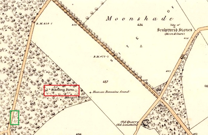
Turn right off the A93 at Cargill onto the side road by Keepers Cottage and up the hill to Gladsfield Wood at the top on your right. Park up at the top side of the Wood and walk straight along the narrow track for around 450 yards and what may be the remains of the stone will be seen between a pair of mature trees.
Archaeology & History
In 1862 the stone was described in the Ordnance Survey Name Book for Perthshire:
‘And about 150 yards from the same object [Hangie’s Well], in a north-westerly direction, there is a small Standing Stone, having the appearance of the ancient monumental standing stones.’
It seems the stone had been removed by the time Fred Coles (1909) came to see it nearly fifty years later. He told us:
“On the day of my visit the mist was so abnormally dense and confusing that it was with considerable difficulty the wood itself was identified; and as its interior is an utter wilderness of trees, shrubs, brambles, broom, wild roses and tall grass, besides being a pheasantry, it is just possible that the monolith searched for evaded my zeal. I think not, however, because, hearing a hedger at work on the Newbigging side of the wood, I made for him; and after plying him with various questions, could get no statement to the effect that he had, though living so near, ever seen any conspicuously tall Stone in the wood.
“On retracing my steps, I searched a fresh portion of the wood, and noticed one biggish block of whinstone lying on the grass in a slight hollow of the ground. It was somewhat cubical, about 2 feet 6 inches square, and fractured. This may he a portion of the former monolith, possibly; and with this dubious result I had to be content.”
In 1967 the archaeologist O.G.S. Crawford described “a sharp-edged boulder standing near the spot marked on the map,” but was not certain if it was the stone. It had no markings on it.
25 in OS map of 1866 showing original position of stone outlined red and position of possible remains of stone in green
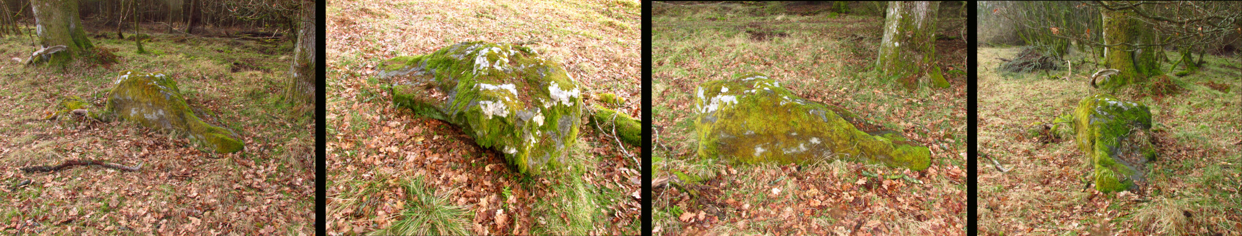
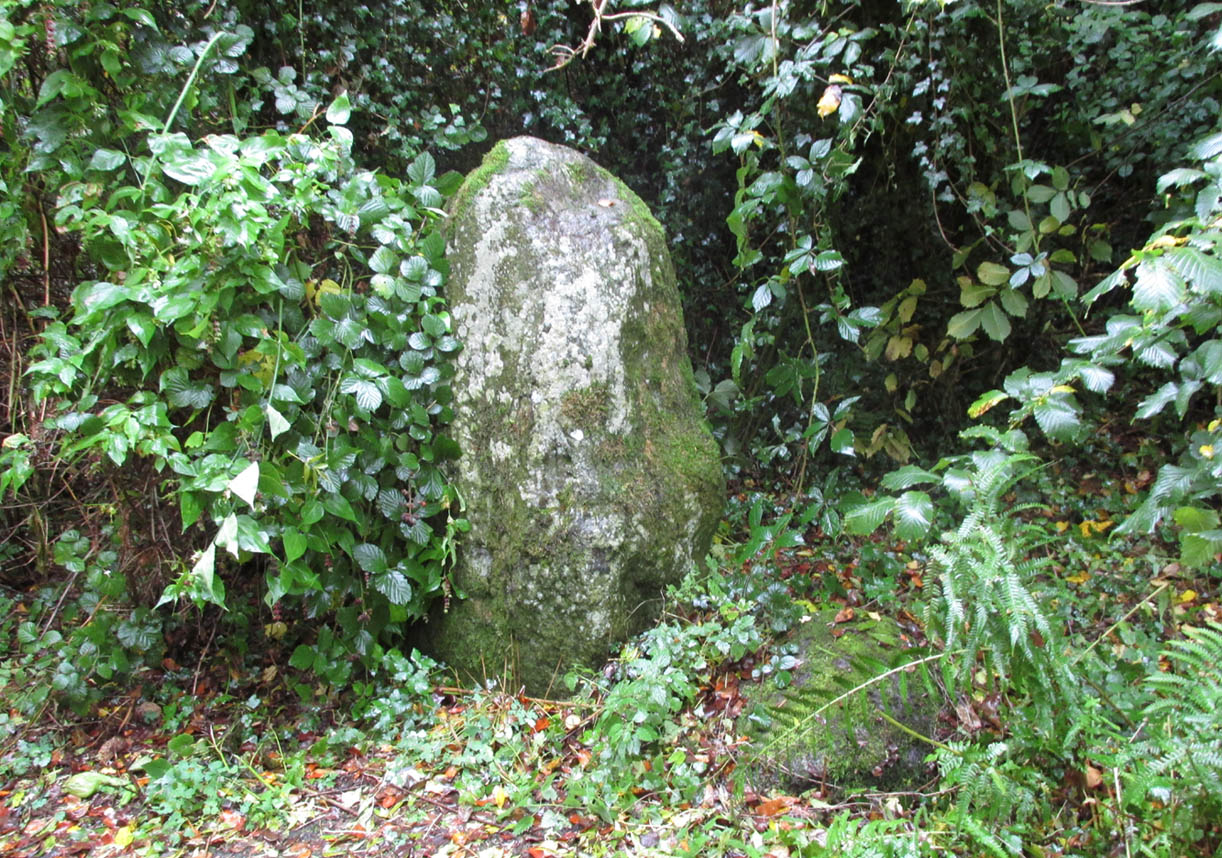
Moving on to 2020, and I found the same impenetrable jungle that Coles described more than a century earlier. When a site has been destroyed I can normally take a photograph of where it once was, but not in this case. I continued westward over difficult and potentially ankle snapping terrain that had recently been replanted with conifer saplings, until I got out of the planting area to a line of mature trees next to the track through the wood.
One large elongated stone presented itself that had clearly lain there for many years judging from the moss growth, a short distance away at NO 15641 35478. Could this be the top part of the standing stone, dragged from its original position some 500 feet to the north-east? It is of grey whinstone, heavily veined at the base, with white quartz and tapering to a pointed tip. It has a squarish base measuring approximately 3 feet across by at least 2 feet deep and is some 7 feet in length. It doesn’t look to be natural, so is it a likely candidate for our missing stone? Felled by a man with a hammer and chisel and dragged by a heavy horse to the edge of the field as part of the ‘improvements’, so beloved of nineteenth century landowners…
We can’t prove it is the remains of Hangie’s Stone which may, after all, still lie buried in the boscage…
The possible remains of Hangie’s Stone
The stone in its original position was next to the Roman road from Camelon via Stirling and Muthill to Kirriemuir near to the junction of a road to Inchtuthill Roman Fort, so may have once been a way marker, although it is not of Roman origin.
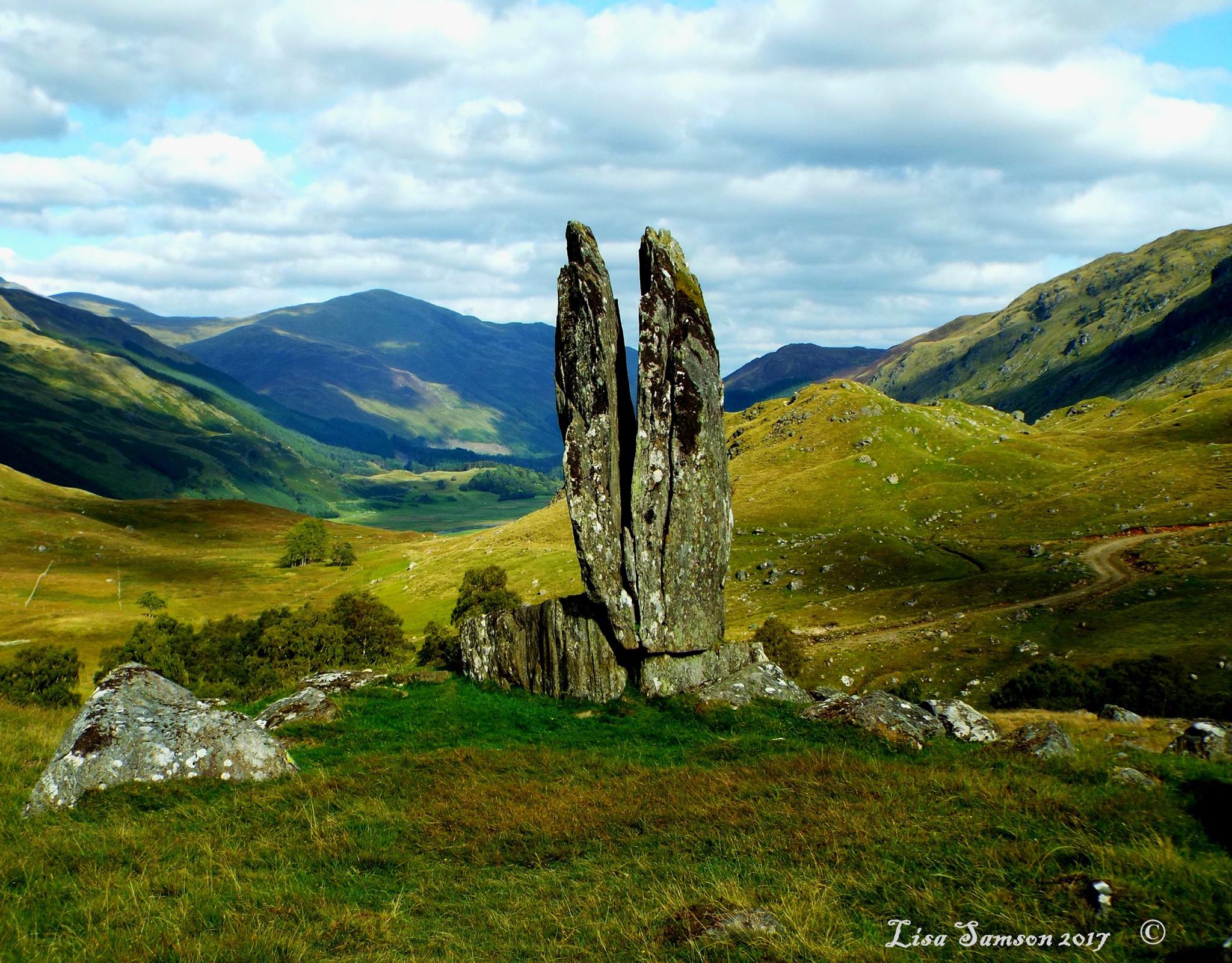
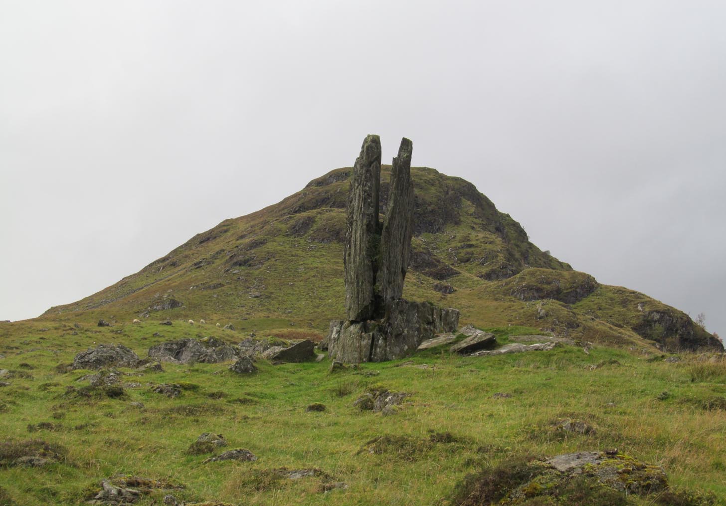
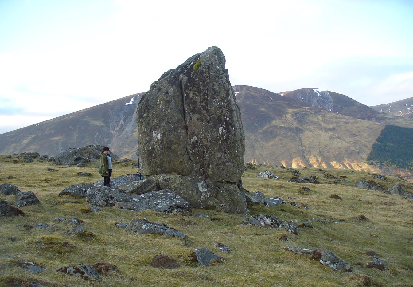
Clach na Sgoltadh, Glen Lyon (photo – Lisa Samson)
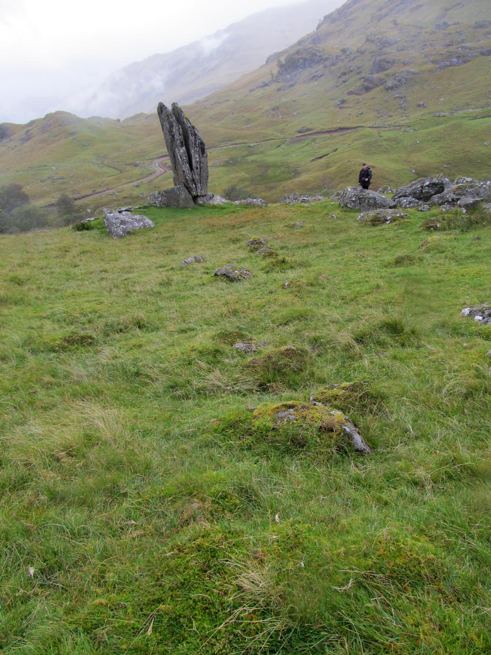
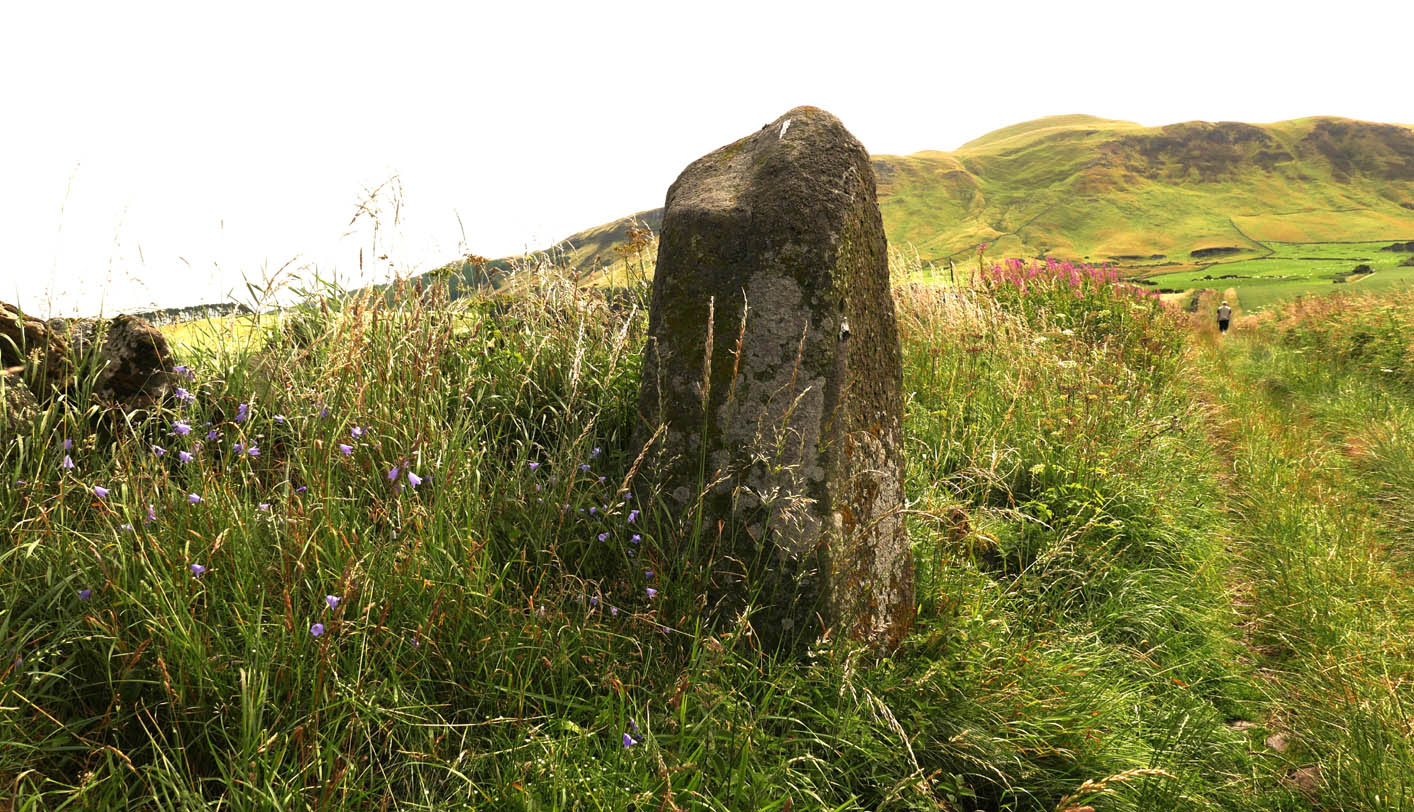
From Fortingall take the road into the legendary Glen Lyon. About 8 miles along, a short distance past the Adamnan’s Cross standing stone, you reach the tiny hamlet of Camusvrachan. On your left is a singular dirt-track, past some cottages. Go along here and over the river bridge until you reach the junction on the other side. From here, turn right and a half-mile on when you reach the farm and manor-house on your right, park up. From here you’ll see a track going uphill. Walk straight up and after a half-mile or so, keep your eyes peeled to your right. You cannot fail to see this impressive giant on the slopes above you!
Archaeology & History
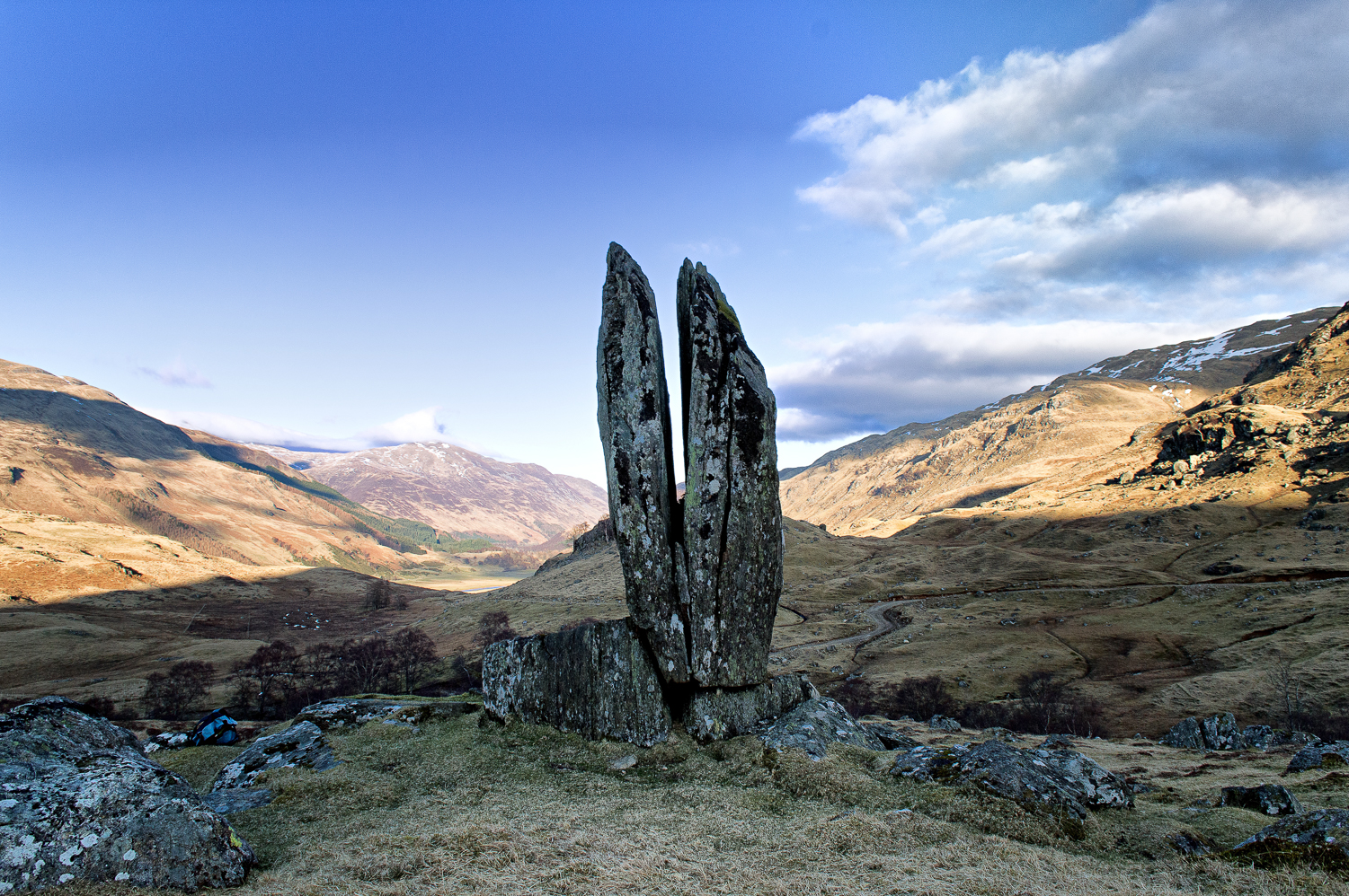
This is a truly mighty monolith! — a beauty no less! Standing upon a rocky ridge nearly halfway along the glen, the landscape it looks across is, without doubt, some of the finest in the British Isles. To our ancestors who, until just two hundred years ago peopled this and nearby glens in great numbers, this great stone would have been well known and had old myths told of it. Today we have only bare fragments.
To give an ‘archaeological survey’ of any kind to this site would seem somewhat of an anathema, as it is generally deemed to be little other than one of Nature’s incredible creations. We’ll come to that in a minute. But what is quite certain is that a line of very old and very low-lying walling runs from up the slope and almost straight down to Clach na Sgoltadh. You can see it pretty clearly in the photograph below. The walling stops at the giant stone and continues no further downhill from the other side of the giant upright.
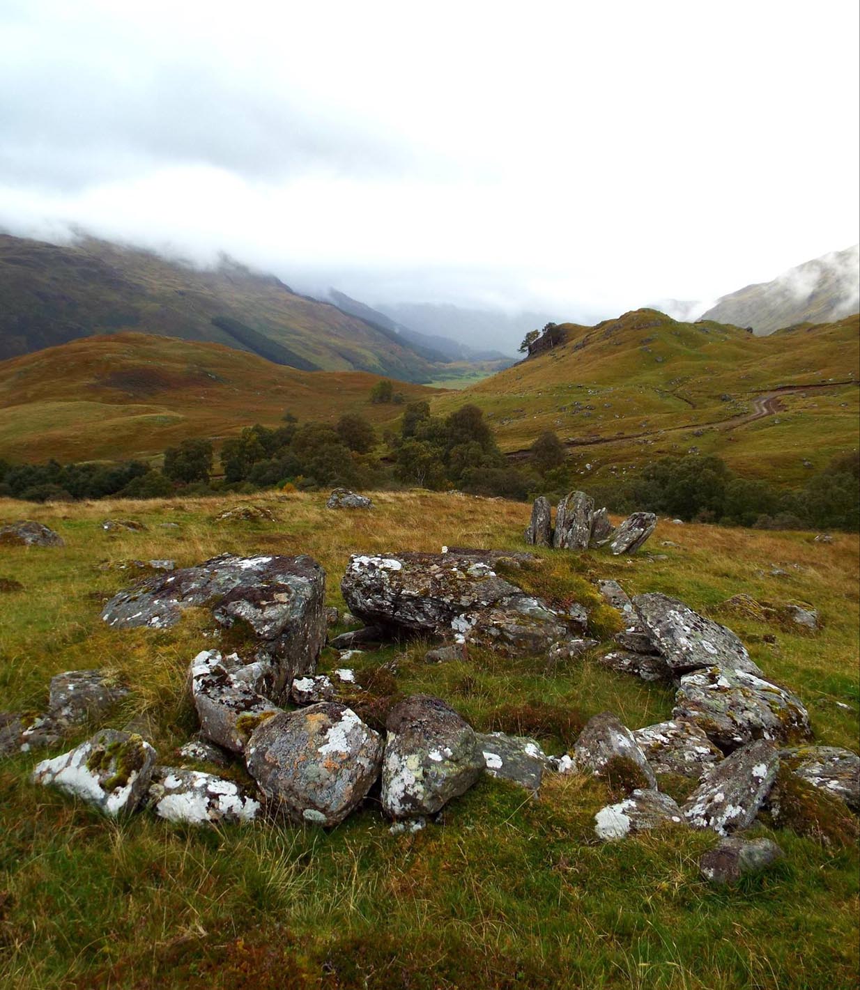
Walk diagonally down the slope about 30 yards south-east from the stone and you’ll find a small but distinctly man-made ring of stones, low to the ground, with an entrance on its northeastern side. It’s somewhat of a puzzle as it’s too small for a hut circle (I laid down in it in various ways and found you’d have to lie foetal all night if you were to use it as your own little abode), and it equally too small as an animal pen – unless it was for just one animal, which is most unlikely. The small circular construction wouldn’t seem to be prehistoric, but it would be good to know what it is.
So, we do have some very slight archaeological association with the site, albeit minimal, with the very ancient walling that leads to the stone being the most intriguing.
Small stone ‘hut’Low line of walling
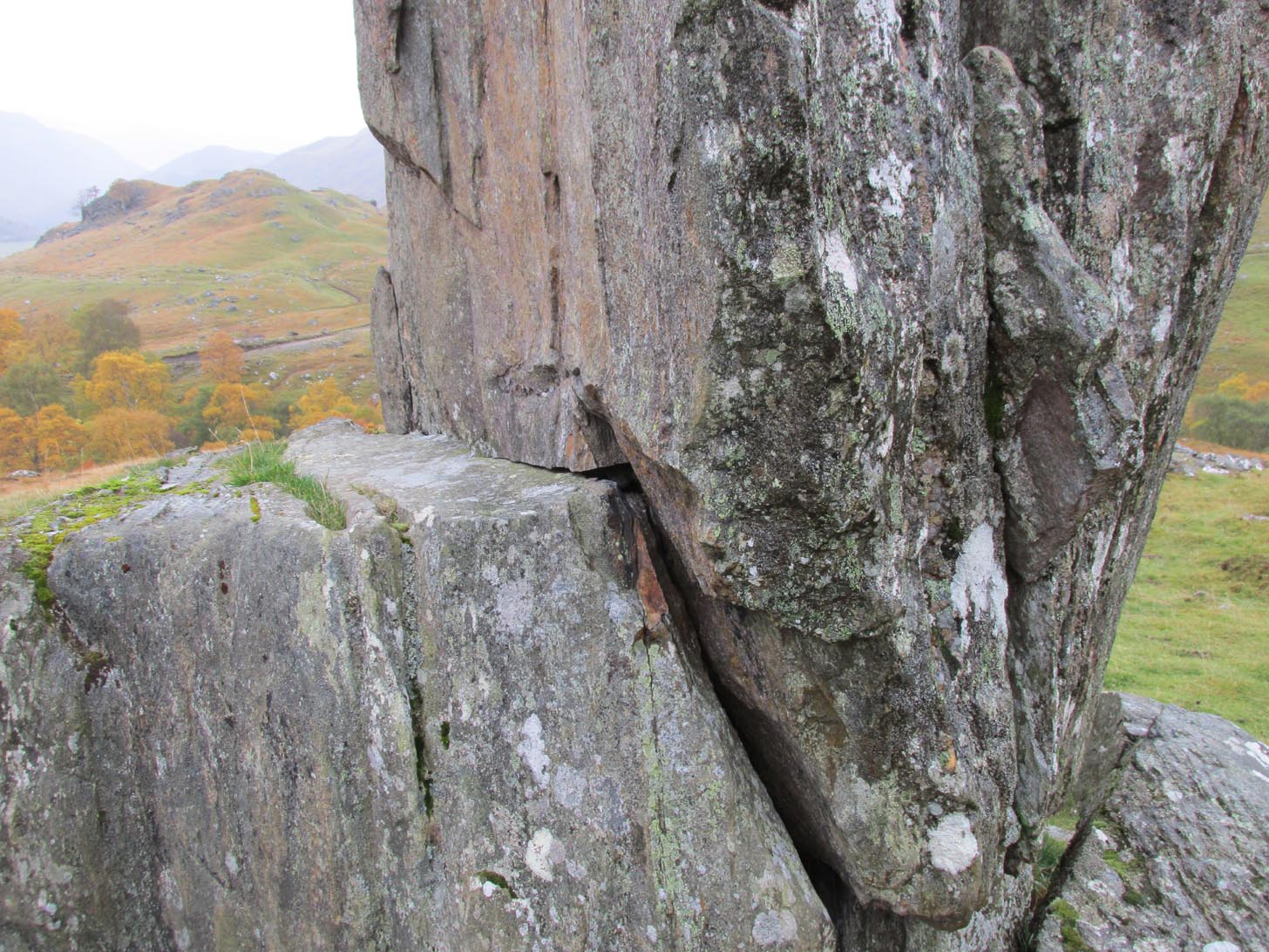
The stone is generally attributed to be a geological creation. I certainly cannot say, as I have no expertise in the subject. However, in the opinion of just about everyone with whom I’ve visited this stone, I seem to be the only one who doesn’t think it’s man-made. A number of people have each insisted to me that it’s been stood upright by humans due to the quite distinct ‘squaring’ of the upright stone, particularly at the north-facing base. —and been seemingly bemused at my own lack of conviction. It does look as if it could have been cut and squared just as they all say but, let me repeat, I’m no expert at geology, and so all I can say is that I simply don’t know one way or the other. (useless prick that I am!)
“Perhaps a stone mason might know?” someone suggested—which seemed to be a good idea. Certainly a stone mason would surely be able to tell if it had been cut and dressed at the base, where it fits into the large earthfast rock….
Cue Chris Swales: a reputable stone mason from near Skipton, North Yorkshire. Chris and his friends took a week long whistle-stop tour in and around the Loch Tay region and thought they’d visit Glen Lyon. I heard about this and so asked him if he’d have the time to visit this stone giant and, if possible, let us know his opinion: is is a natural obelisk, or does it look to have been erected by humans? I told him my opinion and that of the geologists who give it an entirely natural provenance.
It was a few weeks later when he got back in touch and I asked him if he’d been up to Clach na Sgoltadh.
“I did,” he said. “it’s bloody impressive Paul. And what a gorgeous landscape too. I’d love to go there again.”
“Aye, it is Chris. And what did you think of the giant stone then? In your opinion is it man-made or natural?”
“Well I don’t know for certain Paul,” he said, “but in my opinion I’m 95% sure that it’s man-made.” He said it plain as day, just like a typical daan-to-Earth Yorkshireman. Chris isn’t into any the energy ley-line stuff, so his words carry more weight than those who wanna spice-up a site by projecting their own beliefs onto a place. As a result, I was somewhat taken aback by his words.
“What—are you sure Chris?!” I asked.
Cut & dressed stone?
“Like I said – I’m not 100% sure Paul. I can’t really say it 100% – but I’m 95% certain that people cut and dressed the base of that stone and put it there. If it’s natural, then I’d like to know how they think that’s the case. I’m willing to be shown otherwise, but in my opinion, on the whole, it’s man-made. People stuck that stone there!”
It would be great to get another stone mason’s opinion about this site; and it would definitely be good to read a geological viewpoint, but I’m not aware of any papers regarding this stone. (does anyone know of any?) For my part: I can only reiterate that I’m ‘unsure’ whether or not this is man-made. I’m simply not qualified to give an objective opinion.
The curious thing is: if this isNature’s handiwork, then it would have been held in greater reverence to our ancestors than if it had been erected by people. Impressive creations of Nature were always deemed to be inhabited by genius loci of truly archaic potency. And in these deep impressive mountains, where the names of nature spirits still abound, this—without doubt!—would have been a place of considerable awe and sanctity. May it remain as such…
Folklore
Looking to the west immediately uphill and behind Clach na Sgoltadh is the rising rounded hill of Creag nan Eildeag. Legend has it that the great Celtic hero Fionn stood atop of this crag and fired one of his arrows at the stone, splitting it in half and leaving the stone as we see it today.
In a small cleft in the stone, quartz deposits can be seen along with an effigy of the Virgin Mary. However, the title of the Praying Hands of Mary is a modern attribution and has no historical or mythic veracity.
References:
Stewart, Alexander, A Highland Parish; or, The History of Fortingall, Alex MacLaren: Glasgow 1928.
From Crieff central, take the A85 road east out of town where the golf club is on your left. Park up and ask the helpful lads who work in the shop, who’ll direct you to the standing stones on the golf course. The cupmark is on the second stone along the row of stones from the direction you’ve approached from.
Archaeology & History
Here’s another one of those petroglyphs only of interest to those with the madness in their bloodstream! Found within the ruins of the Ferntower megalithic ring is a distinct single cupmark on what John Coles (1911) called ‘Stone D’ in his survey:
The stone in questionCupmark, lower centre
“Stone D, a boulder of whinstone also containing seams of quartz, 5 feet 6 inches in length and breadth, and 2 feet 3 inches above ground. At some period the intention of blasting this block must have been considered, for there is the beginning of a jumper-hole near the centre of its upper surface. Close to this unmistakably modern hole there is one single genuine cup-mark about 1¼ inch in diameter.”
A note of this was also made when Aubrey Burl (1988) surveyed the site, who pointed out that in accordance with a characteristic found at other ‘four poster’ stone circles, the carving is “another example of a decorated stone on the eastern side” (my italics) of such a ring.
Folklore
Although we have nothing specifically relating to the carving, it’s worth noting that when we visited the stone circle, the groundsman told us that it had been a place where local people gathered at summer solstice.
Standing Stone (lost): OS Grid Reference – SU 161 432
Archaeology & History
In William Stukeley’s Stonehenge, he described a number of monoliths outlying Salisbury Plain that also possessed a prehistoric pedigree. Most of them have been recorded, but this one seems to have been forgotten about — perhaps by virtue of it having fallen into the River Avon! Edgar Barclay (1895) described it in his fine survey, saying:
“In the bend of the river below the village, is a large submerged stone; only during drought is any portion of it visible above water; it can, however, in ordinary times, be dimly seen from the bank, which is of chalk, here very steep and overgrown. The country people assert that a metal ring, “turning always,” is let into its upper end. Legend relates that when the Devil brought the rocks of Stonehenge from Ireland, tied together with withes, this stone escaped from the bundle and fell into the river. Its position forbids the belief that it got fixed in the bed of the stream when its passage to Stonehenge was being attempted, for it lies immediately beneath the crest of a very steep bank, and at its most inaccessible point; as the stream sweeps against this, the water must always have been deep at this spot, the open valley would everywhere offer more favourable points for such an operation, especially would this be the case before the Avon was dyked. A boundary stone would have been placed on the brow of the hill; if the stone be a grey-wether, as report says, and as is probable, it may originally have stood on the bank, and “once upon a time”, a ring having been fixed in it, it may have been dragged into the stream to moor a ferry-boat. It lies closely midway between the stone on Bulford Down and that in Durrington fields.”
One wonders if any local people might know more about this…
References:
Barclay, Edgar, Stonehenge and its Earth-works, D. Nutt: London 1895.
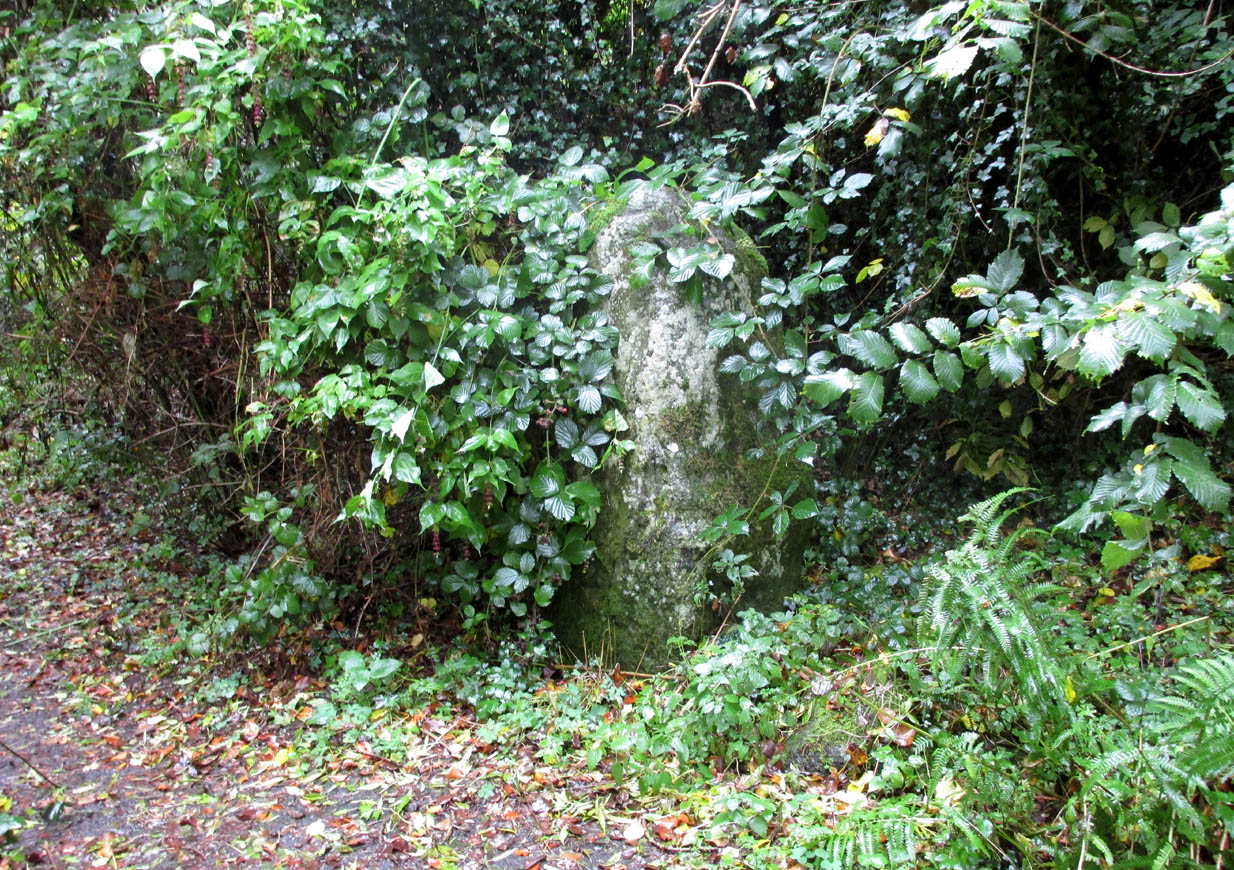
Along the main A913 Perth Road that runs round the northern edge of Abernethy village, as you approach the village from the western side, go right at the mini-roundabout up the Main Street into the village. However, just where this roundabout is, there’s a footpath into the trees known as the Castlelaw. Walk up here, keeping to the left-side of the burn (don’t cross over onto the right-hand side!) and after about 200 yards or so, keep your eyes peeled for a large upright stone, almost overgrown in dark vegetation on your left.
Archaeology & History
An intriguing standing stone in a most unusual position: a small wooded glen with a steep slope on its immediate eastern side, very enclosed. It’s quite a big thing too, standing some six-feet high with the usual worn rounded crown, typical of olde stones.
The olde stone, unmasked
In the very brief account of this site by Hallyburton & Brown (2000) they describe this “previously unrecorded /lost standing stone and possible ruinous stone circle.” This is also echoed in Canmore’s description. A standing stone we certainly have, but in several visits here there was no evidence of any stone circle either side of the burn. It was suggested that the “circle” may once have been atop of the slope immediately above this stone, but again there is no evidence at all to suggest this and old maps show nothing. I’m extremely doubtful of any megalithic ring here (I’d love to be wrong though).
References:
Hallyburton, I. & Brown, R., “Abernethy Den (Abernethy Parish),” in Discovery & Excavation Scotland, New Series – volume 1, 2000.
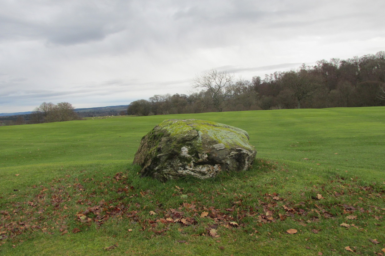
To find this stone take the A91 to Gateside and turn into Station Road. Follow to the end, then turn right. 200 yards on there is a parking spot for the Bunnet Stane, and a track to follow. As you go up this track towards the Bunnet, approximately 280 yards on is this beauty.
Archaeology & History
At over 6ft high, this previously unrecorded standing stone has quite a presence on this slight incline. It’s hard to tell the true height as he is set in a grassy bank with a drystane wall behind. It has obviously been used as a gatepost at some time in the past, but there’s no hint of being moved for that purpose. There are many ancient relics in this area and there used to be a stone circle across the road and behind Nether Urquhart Farm, along with several burial cairns. I reckon there is a lot more to be found, and we fully intend to go back there.
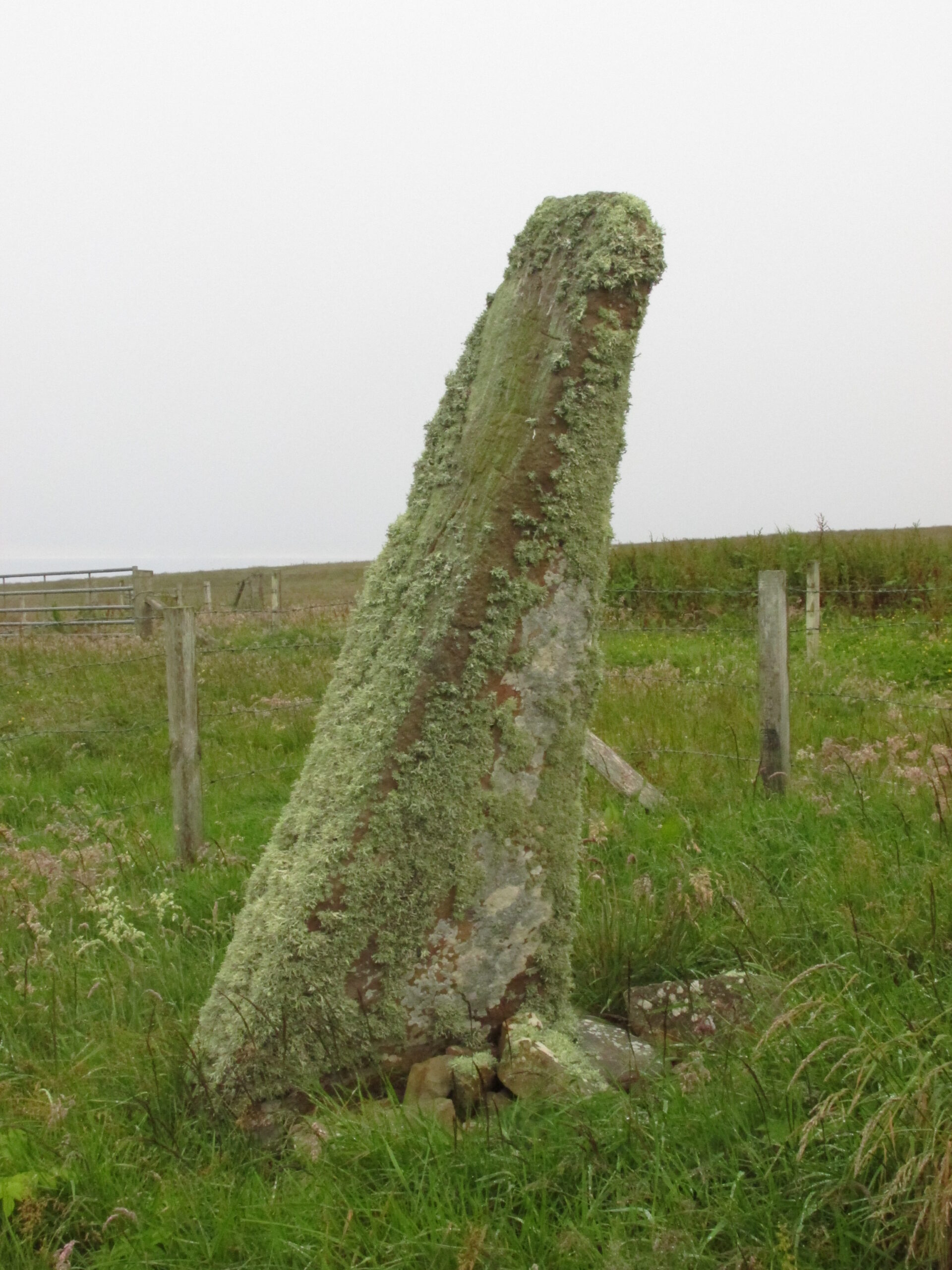
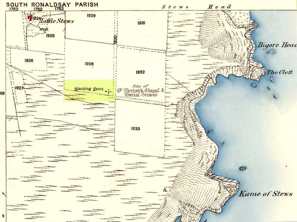
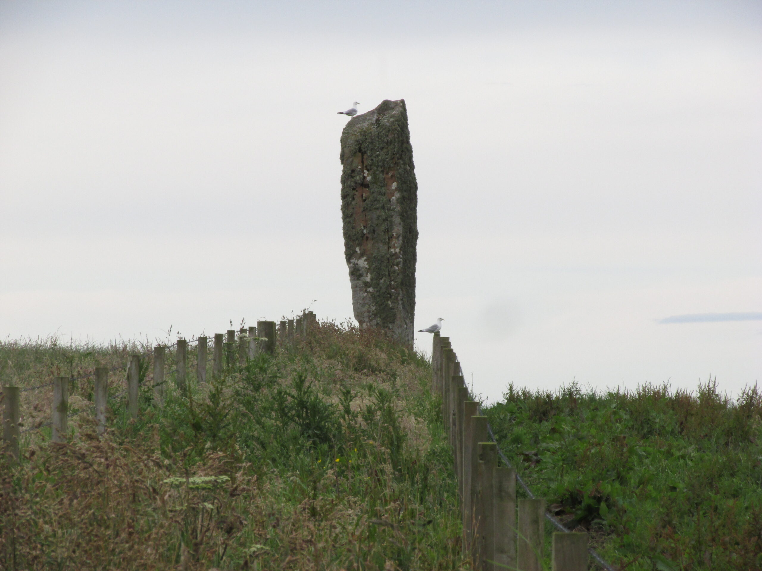
Take the third left road off the A961 past St Mary’s Hope, travelling south, taking the right fork at Lythes, and continue down to the end of the metalled road. From there, walk up the slope to your right (south) and follow the fence on your left into the next field and the stone will be seen in a fenced enclosure.
Archaeology & History
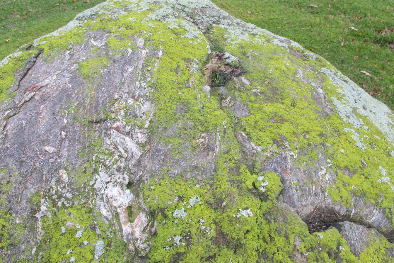
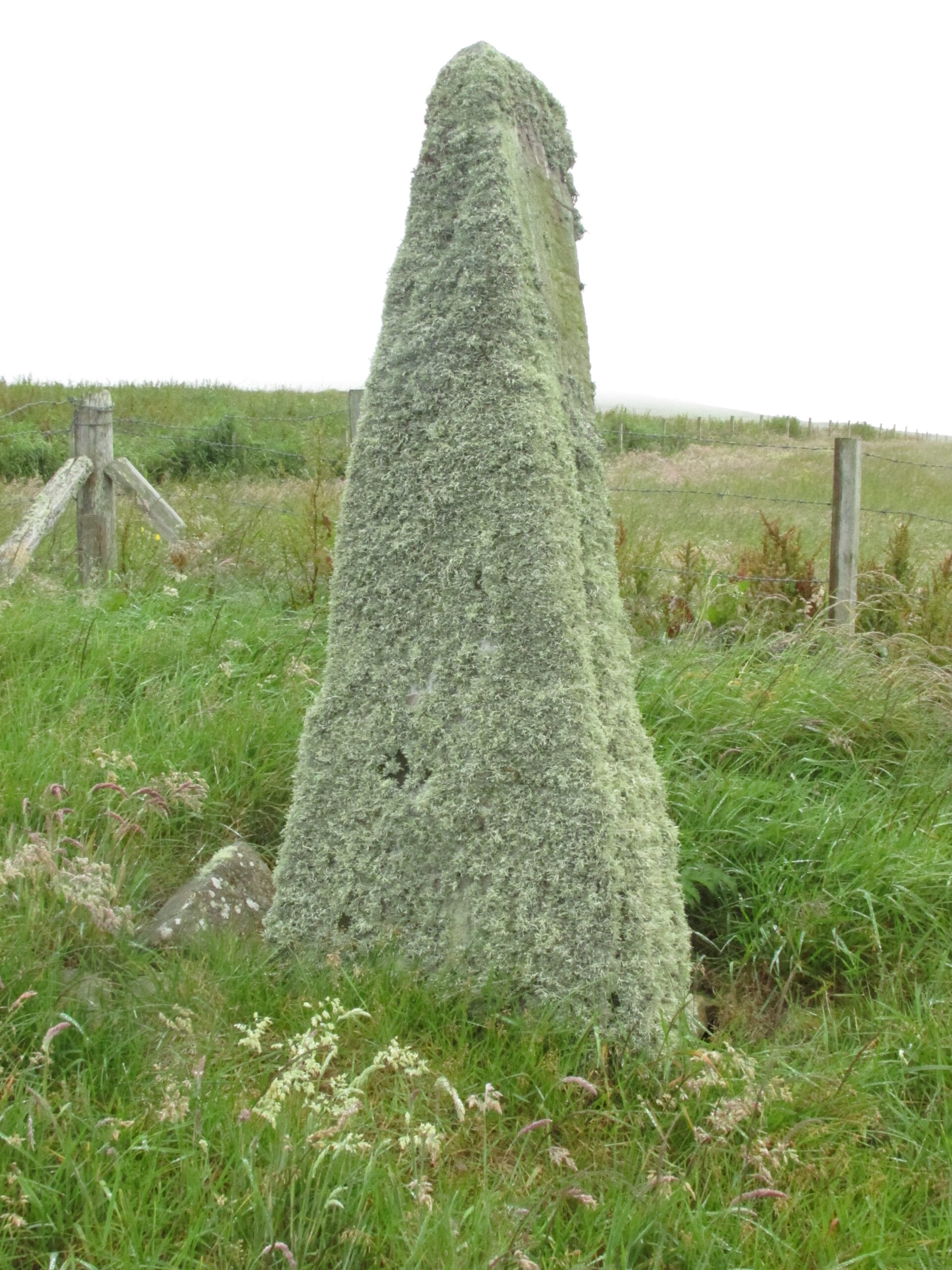
Two things strike you when you first see this stone, the triangular shape of the east facing side, and the lichen which covers this face and much of the rest of the stone giving it the distinct illusion of having a green velvet coat! From another angle it has a distinct lean and there are quite a few packing stones around its base. The Royal Commission inventory (1946) describes it thus:
Stone on 1881 map
“On a ridge barely a quarter of a mile S of the farmhouse of Stews is a triangular block of red sandstone nearly 6 ft high, set with a packing of small stones at the base and with its axis N-S. At the bottom where it is widest it measures 2 ft. 6 in. across and is from 12-13 in. thick. As it rises it tapers gradually to a pointed top, which is slightly inclined towards the W.”
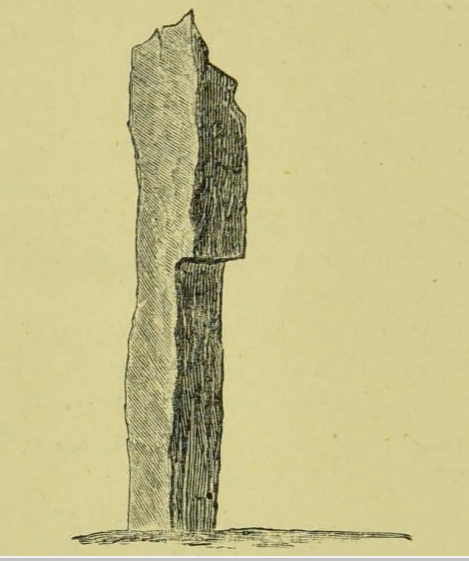
George Low on his 1774 tour wrote:
“Left this spot, and May 12th, proceeded southward by Stowse head; observed on the hill the remains of a tri-angular monument, but very much defaced, and two of the stones broke to the stumps. Tradition is there none as to the reason &c. of its erection. The figure with a plan follows…”
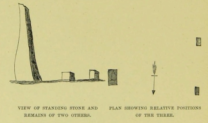
George Low’s 1774 sketchA coat of lichen
There is now no trace on the surface of the other two stones of this group so we are fortunate to have Mr Low on the spot sketch to record them. The stones would have been visible to the seafarers of times past who may have used them as navigation landmarks in pre-literate times, this being one of a number of surviving coastal stones on the Orkneys but whether they were erected for this purpose cannot be known. If you’ve been to see the Sorquoy stone up the coast, the surviving Stews stone is worth the journey if only for its ‘velvet’ coat.
References:
RCAHMS, Twelfth report with an inventory of the ancient monuments of Orkney and Shetland, 3v. Edinburgh. 1946
Low, George, A Tour Through the Islands of Orkney and Schetland…collected in 1774, William Peace & Son: Kirkwall 1879.
Acknowledgements: Big thanks for use of the 1st edition OS-map for this site profile, Reproduced with the kind permission of the National Library of Scotland.
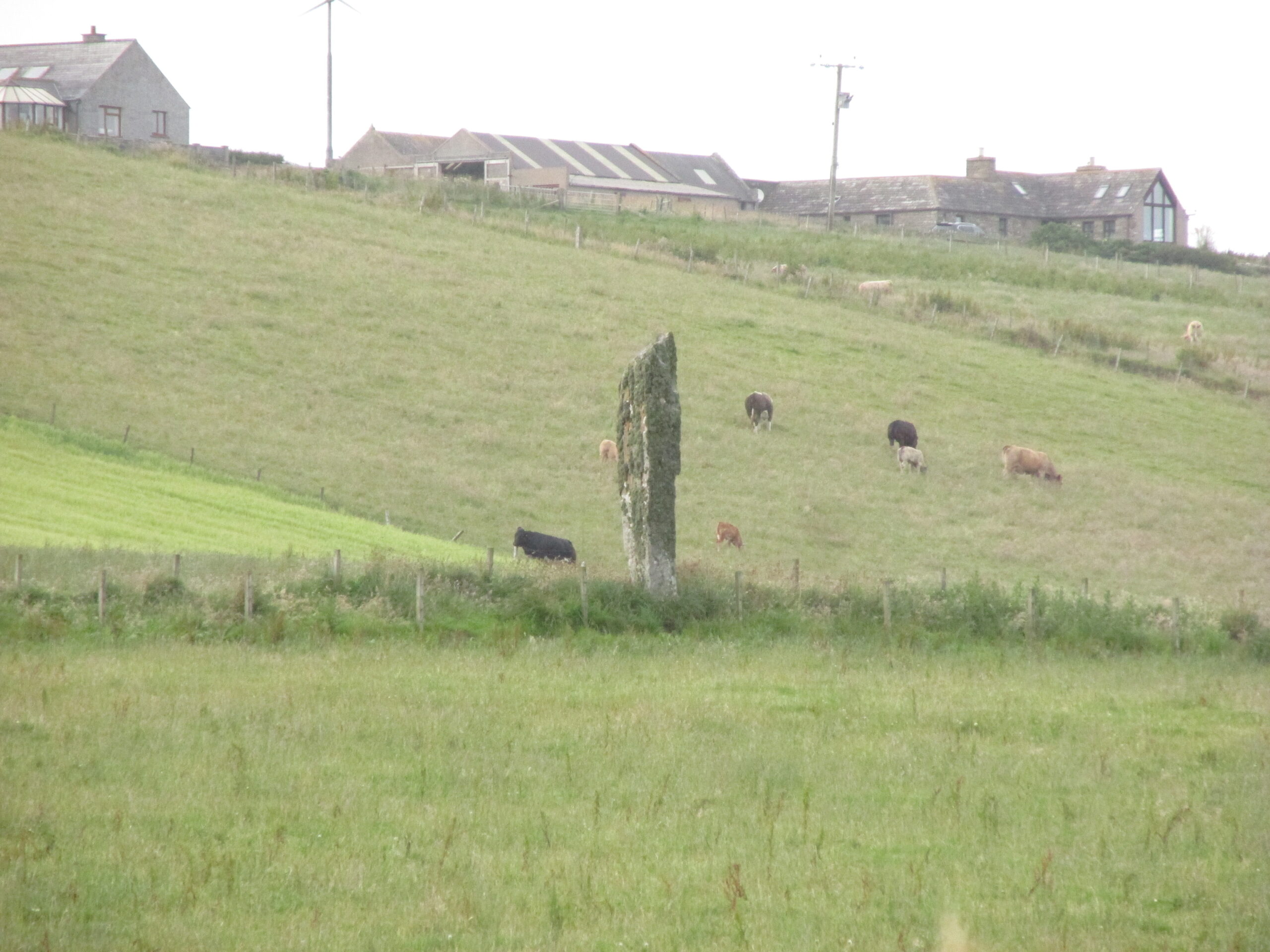
Travelling south on the A961, take the first road left past St Margaret’s Hope, and follow it over the cross roads, and down the hill towards the sea, and it’s visible on the left hand side. You can’t miss it! It’s accessed by a narrow pathway which has been partly ditched – be careful!
Archaeology & History
View from the SEView from the track – SW
One of the less well known but most impressive of the Orkney standing stones, and seemingly one of the least visited. On my visit in July 2019, it was clear no one had walked the path for several months. The Royal Commission Inventory describes it as being, “14′ – 14′ 6″ high with some packing at the base. At 3′ above ground level, it is 2′ 6″ wide and 18″ thick, thickening to 21-22″ as it rises.”
It has a distinctly top-heavy look, and although invisible from the west above the brow of the hill, it can be clearly seen from the sea.
George Low visited the stone on May 11th 1774, saying:
‘In this beautiful hollow, in a cornfield, saw a large erected stone about 16 feet above ground, probably monumental, tho’ tradition is silent about it, and by digging nothing was found that could certainly prove this’.
Described by local historian George Barry (1748 – 1805):
George Low’s 1774 drawing
‘To the north (of South Ronaldsay), – at no great distance, is a most beautiful vale, with the ocean on one side, and gently declining hills on the other; which, for the production of every sort of beneficial crop, is far superior to any other part of the island. In the middle of this pleasant spot, on the brow of a hill, is a monumental stone, sixteen feet high, which, like many others through the country, bears no marks of human art, in carving, figures, or inscription. The whole delightful dale is known by the name of Paplay’ .
If you’re in the islands, this impressive stone is certainly worth a detour!
References:
Barry, Dr George, History of the Orkney Islands, Longman,Hurst,Bell & Orme: London 1808.
Low, George, A Tour Through the Islands of Orkney and Schetland…collected in 1774, William Peace & Son: Kirkwall 1874.
Royal Commission Ancient & Historical Monuments, Scotland, Inventory of the Ancient Monuments of Orkney and Shetland, HMSO 1946.
Acknowledgements: Big thanks for use of the 1st edition OS-map for this site profile, Reproduced with the kind permission of the National Library of Scotland.