Not too far from the High Laithe cup-and-ring stone. Along the A6131 out of Skipton, park up at the Rendezvous hotel and go up the road on your left, over the canal. As you approach the second house up, note the rock on the right-hand side of the tiny road, perched on the edge above the stream, with ivy creeping up one side of it. That’s it!
Archaeology & History
This stone was moved to its present position a few decades back, sometime before Hedges (1986) first recorded it in his Carved Rocks work. It’s a reasonably large boulder, resting on the slope above the drop to the stream below, and will probably drop into the waters in the not-too-distant future. Whether the stream had any initial relationship with the cup-markings etched on its surface, we’ll probably never know (a number of rock art students love the water-stone relationship — and this one is no doubt in their listings!). Its first literary appearance by Hedges described it thus:
“Large fairly smooth grit rock sloping down to stream at E and into ground and grass at W. Eleven cups, circle of nine very small cups at one end, groove from depression, one other groove and possible cup.”
Lower half of CR-016
Which just about does it justice. When we visited the place yesterday, the cluster of small cups at the top of the rock were difficult to see clearly in the grey daylight; but what seems to be another 2 cups (not in Hedges, nor Boughey & Vickerman’s [1986] survey) may be on the lower-half of the stone, and can be seen in the photo here. We need to go back again on a bright day and catch the stone in a different mood to suss out whether we were just seeing things.
References:
Boughey, Keith & Vickerman, E.A., Prehistoric Rock Art of the West Riding, WYAS: Leeds 2003.
Hedges, John (ed.), The Carved Rocks on Rombald’s Moor, WYMCC: Wakefield 1986.
From Skipton town centre follow the A6131 road south, out of town, for less than a mile, and turn left up Cawder Lane. Avoid following the road into the housing, instead bearing up the country lane to your left. Just before reaching the farmhouses 200 yards up, note the stony hilltop above you on your left (up behind Horse Close Farm). Walk up there for 250 yards NE and you’ll find it!
Archaeology & History
Horse Hill enclosure, looking W
This is an impressive site. I’d say very impressive! (but I’m easily pleased) Oddly however, I can’t find a damn thing about this place in any of my archaeo-records and it appears (as far as I’m aware) that no survey has ever been made of it. Which is bloody incredible! Indeed, the only archaeological notes that appear to exist about this very impressive and well-preserved Iron Age enclosure, states, “Subcircular enclosed settlement on Horse Close Hill 250m north of Horse Close Farm.” That’s it! Nothing else! So I’m afraid you’ve only got my crappy description of it to go on for the time being…
As the aerial image below shows, this is a large oval-shaped enclosure, defined primarily by an almost complete ring of double walling arranged around this hilltop site. Measuring approximately 78 yards (71m) north-south, and nearly 75 yards (70m) along its longer east-west axis, with a circumference of about 235 yards (215m), many of the upright stones which define its edges stand between 1-3 feet in height. Some of these stones have obviously been moved into position by the lads who built the structure, but the site has also taken advantage of a number of large earthfast boulders in its construction.
If you walk around the edges of the walled enclosure, almost every bit of it is clearly visible. Between the defining inner and outer walling of the structure we find sections of the site packed with smaller stones, giving the impression that it may once have been filled all round, making the walls thick strong defensive ones. But without a more detailed investigation, we’ll never really know…
Horse Close settlement, looking NEAerial view of enclosure
It is clearly very similar in structure, and probably date, to the well-known Brackenhall circle on Shipley Glen, near Baildon (though the nature of the Brackenhall site has long been a topic of controversy). And, as with the Brackenhall site, a number of cup-and-ring stones are found close by — including the Great Wood Laithe carving in the field immediately below on the west side. I’ve also found a similar structure to this on the hills above Steeton, a few miles to the south (though it’s not as well-defined as this one).
Although the site is mainly defined by its oval walling, we also find other stretches of walling that run outwards from the central site: one in particular running north-east for 35 yards out towards a small standing-stone further up the field. Other curious earthworks and remains scatter the fields on the eastern sides of this main feature, which the helpful farmer here pointed out to us.
Worth the short trek if you like your cup&rings! On the Aire Valley Keighley-to-Skipton road (A629), as you approach the southern outskirts of Skipton, take the turning at the roundabout as if you’re going into the town up the A6131. Go over the next roundabout a coupla hundred yards on, then 200 yards further on note the right-turn up over the canal (big hotel just here, where you could park up). Walk over the canal up the tiny country lane. Ignore the first left turn and walk up, bearing next left uphill and onto the footpath. Walk up the hillocky quarried bit until you reach the stile in the wall. Once on the other side, look in the walling 20 yards uphill. You can’t miss it!
Archaeology & History
First described by Messrs Hartley and Radley in the Yorkshire Archaeological Register of 1968, this small “standing stone”, less than three-feet tall, has a distinct cup-and-double- ring carved onto its upright north-facing edge. The outline of the carving is visible even in bad light, though you might wanna rest and gaze for a minute or two for yourself and the lighting to adjust if it’s a grey day. There’s another cup-marking below the bottom right of the double-ring, with another ‘possible’ just above ground-level.
References:
Boughey, Keith & Vickerman, E.A., Prehistoric Rock Art of the West Riding, WYAS: Leeds 2003.
Hedges, John (ed.), The Carved Rocks on Rombald’s Moor, WYMCC: Wakefield 1986.
Pretty simple really. Go up the B6265 Skipton-Rylstone road for about 3 miles, past the Nettlehole Ridge woodland on your right. The next turn along to your right, up the track, is Scale House. Go past this until you get to Scale House Farm. The remains of the burial mound is in the field to your left, just before the farm. Knock on the door and ask!
Archaeology & History
This ‘tumulus’ (as it’s marked on the OS-map) was one of the many explored by the legendary reverend William Greenwell (1864) in the middle to latter-half of the 19th century. His description of the finds at Scale House were considerable; thankfully our old Yorkshire antiquarian Edmund Bogg (1904) shortened it and told us the following:
“The tumulus was 31 feet in diameter and about 7 feet high; it opened from the southeast; the soil immediately under the sod consisting of yellow clay to a considerable depth; then layers of blue clay… Exactly in the centre…at a depth of 7 feet, and on a level with the plane of the field, was found an oak coffin, formed out of a tree, split and hollowed-out, and placed due north and south, the head being placed to the south, as that as the larger part of the tree. After being exposed to the air for about 2 minutes, the bared coffin parted at the sides, and could not be moved except by detached pieces. The body had been wrapped in a cloth or shroud of texture resembling wool and coarsely-woven, of which there was a considerable quantity remaining; but the body itself was dissolved… The interment was considered to be that of an ancient Briton… The learned antiquary said it was the only instance (except the one at Gristhorpe, near Scarborough) where an interment in an oak tree hollowed out had a tumulus placed over it. It was more than 6 feet in length inside and about 7 feet 6 inches outside. The remains were carefully replaced and the mound restored to its former shape; a small leaden tablet being placed within, stating that it had been opened in AD 1864.”
Folklore
Jessica Lofthouse (1976) listed this as one of the places reputed to be an old fairy haunt, wherein “the folk of Scale House discovered a fairy kist or chest.”
References:
Bogg, Edmund, Higher Wharfeland, James Miles: Leeds 1904.
Greenwell, William, British Barrows, Clarendon Press: Oxford 1877.
Lofthouse, Jessica, North Country Folklore, Hale: London 1976.
There are several ways to get here, but I took the one from the road (B6265) walking up the track into Crookrise Woods. Unless you’ve got a decent OS-map with it marked on, this might take some finding to some folk as it’s tucked away on the northern edge of Crookrise Woods (which one Southerner bloke told us was private – though he was ‘allowed’ there!). It’s right on the rounded knoll at the top of the woods, beneath the prominent slopes which lead to the moor.
Archaeology & History
Our old mate and Yorkshire historian Arthur Raistrick seems to have been the first to describe this place in the Yorkshire Archaeological Register of 1964 – though the holy wells writer Edna Whelan told me she knew about the place many years back. Today hidden in woodland and mostly overgrown, Raistrick’s brief description of the place said:
“A small stone circle of six stones set symmetrically within a diameter of 26 feet. The stones vary in size from 21 to 58 inches. Surveyed 1963.”
The site has been badly affected by the erosion of time, forestry and god-knows what else. Scattered around are numerous small stones giving the impression that it may once have been a cairn-circle, more than a stone circle. Four of the six stones mentioned by Raistrick (1965) are visible, but none are impressive – and unless you’d read about the place first or found it in Mr Burl’s Stones Circles of Britain… (2000), you wouldn’t really give it the time of day.
Although sadly disappointing in its present status – completely surrounded by trees, with no view at all – it seems probable that it would have had some geomantic relationship with the hillfort-looking site of Rough Haw immediately west, and very probably the adjacent ritual site of Sharp Haw. It seems that the equinox sun would set between Rough Haw and the other small rounded hill above.
References:
Burl, Aubrey, The Stone Circles of Britain, Ireland and Brittany, Yale University Press 2000.
Follow the same directions for getting to the Black Hill Round Cairn. It’s less than 100 yards away – you can’t miss it!
Archaeology & History
This is a superb archaeological site — and it’s bloody huge! It’s big and it’s long and it sticks out a bit – which is pretty unique in this part of the Pennines, as most other giant cairns tend to be of the large round variety. Although the site was originally defined by Arthur Raistrick (1931) as a long barrow, J.J. Keighley (1981) told how, “it was found to be a round cairn imposed on a long cairn.” And it’s an old one aswell…
Near the SE end of the giant cairnClose-up of the main cist
More than 220 feet long and 80 feet in diameter at its widest southeastern end, as we walk along the length of the cairn to its northwestern edge, its main body averages (only!) 45 feet in diameter. Made up of tens of thousands of rocks and reported by Butterfield (1939) to have had an upright stone along its major axis, the “height varies from 4-8ft, but the cairn has been much despoiled and disturbed,” said Cowling in 1946. He also told how,
“Excavation revealed that almost in the centre of the mound were the remains of a cist made of roughly dressed stone flags and dry walling, covered by a large stone. Under a stone slab, laid on the floor of the cist, were fragments of (burnt and unburnt) bone and a small flint chipping.”
This is a very impressive site and deserving of more modern analysis. The alignment of the tomb, SE-NW, was of obvious importance to the builders, believed to be late-neolithic in character. The tomb aligns to two large hills in the far distance in the Forest of Bowland which we were unable to identity for certain. If anyone knows their names, please let us know!
Folklore
The older folk of Bradley village below here, tell of the danger of disturbing this old tomb. In a tale well-known to folklorists, it was said that when the first people went up to open this tomb for the very first time, it was a lovely day. But despite being warned, as the archaeologists began their dig, a great storm of thunder, lightning and hailstones erupted from a previously peaceful sky and disturbed them that much that they took off and left the old tomb alone. (I must check this up in the archaeo-records to see if owt’s mentioned about it.)
References:
Ashbee, Paul, The Earthen Long Barrow in Britain, Geo Books: Norwick 1984.
Butterfield, A., ‘Structural Details of a Long Barrow on Black Hill, Bradley Moor,’ in YAJ 34, 1939.
Cowling, E.T., Rombald’s Way, William Walker: Otley 1946.
Keighley, J.J., ‘The Prehistoric Period,’ in Faull & Moorhouse’s West Yorkshire: An Archaeological Survey, I, WYMCC: Wakefield 1981.
Raistrick, Arthur, ‘Prehistoric Burials at Waddington and Bradley,’ in YAJ 30, 1931.
Various ways here. Best is probably taking the footpath onto Farnhill Moor a few hundred yards east of Kildwick Hall. Head for the cross-bearing Jubilee Tower (supposedly built upon an ancient cairn), NW, keep going past it uphill until you reach the walling 350 yards north, where a seat let’s you have a rest. Climb over the wall! Alternatively, walk eastwards and up through the steep but gorgeous birch-wooded slopes of Farnhill Wood; and as the moortop opens up before you, the great pile of rocks surmounts the skyline ahead. You can’t miss it! (NB: the spot cited on the OS-map as the cairn is in fact another site, 100 yards NW)
Archaeology & History
Its an awesome place in an awesome setting. You can see 360-degrees all round from this giant mass of rocks — something which was of obvious importance to the people who built it. If it had been placed 20-30 yards either side of here, that characteristic would not occur. Indeed, this is the only place anywhere on these moors where such a great view was possible. Important geomancy, as they say (or whatever modern term they give it these days).
Bradley Moor Cairn – looking down to the Long CairnSmall section of the old cairn
Although the tomb is still of considerable size (at least 100 feet across) and made up of thousands of stones, it has been severely robbed of stone in years passed, for walling and other building materials. A number of other small cairns scatter the heathlands a few hundred yards roundabout this central giant (though are hard to find in the deep heather); and there is a distinct cairn circle about 100 yards to the northwest, which has yet to be excavated. This cairn circle can be made out quite easily if you stand on the ridge about 30 yards west of here, looking down the slope. An then of course we have the equally huge Black Hill Long Cairn, less than 100 away, aligned northwest-southeast, which obviously had an important archaeological relationship with this giant round cairn. Also around this and the adjacent long cairn, numerous flints and scrapers have been found, showing humans have been here since at least the early neolithic period. And recently, what seems to be a fallen standing stone has been found laying in the heather, 168 yards to the north.
This site in particular gives me the distinct impression that it was the most important of the various sites upon these moors. It’s got a distinctly female flavour to it – and it’s old name of the Queen’s Cairn seems just right. Maybe it’s the fact that when I first visited the place, a great thunderstorm broke through the previously perfect skies, scattering lightning bolts all round for perhaps thirty minutes — so I stripped myself naked and reached my arms out-stretched, cruciform, screaming to the skies in the pouring rain! Thereafter, no clouds appeared in the skies for the rest of the day. It was a brilliant welcome to the place!
References:
Cowling, E.T., Rombald’s Way, William Walker: Otley 1946.
Keighley, J.J., ‘The Prehistoric Period,’ in Faull & Moorhouse’s West Yorkshire: An Archaeological Survey, I, WYMCC: Wakefield 1981.
Raistrick, Arthur, ‘Prehistoric Burials at Waddington and Bradley,’ in YAJ 119, 1936.
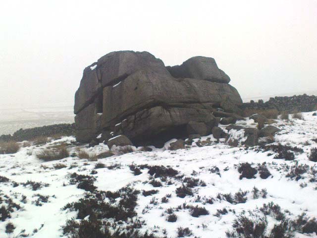
The easiest way to get here is via Cowling – though you can approach the place via moorland roads from Sutton-in-Craven, Oakworth and Keighley, but Cowling’s the closest place (so we’ll take it from there). Turn east off the A6068 up Old Lane at the Ickornshaw side of town and go up the steep and winding road until you hit the moors. Just as the road levels out with walling on either side of the road, there’s some rough ground to your left. You can park here. You’ll blatantly see our Hitching Stone on the moorland a few hundred yards above you on the other side of the road. Walk up the usually boggy footpath straight to it!
Archaeology & History
For me, this is a superb place! Each time I come here the place becomes even more and more attractive — it’s like it’s calling me with greater strength with each visit. But that aside…
Supposedly the largest single boulder in Yorkshire, it possesses several legends, aligns with the sacred Pendle Hill in Lancashire, is an omphalos (centre of the universe spot) and has other good points too! My first visit here was near the end of the Great Drought of 1995. All of the streams and springs had dried up on the moors but, on the very top of this huge rock, measuring at least 8 feet by 4 feet across (and 3 feet deep) was a large pool of water, not unlike a bath, in which a couple of you could easily bathe (and do more besides, if the fancy takes you!). It was surreal! Water-boatmen and other insects were living in this curious pool on top of the rock. Yet all other water supplies for miles around had long since dried-up. It didn’t really seem to make sense.
Crystalline tunnel in the Hitching Stone
On the west-facing side of the boulder, about 8 feet up, is a curious deep recess known as the Druid’s or Priest’s Chair, into which initiates were sat (facing Pendle Hill, down which it seems the equinox sun “rolls”) and is believed, said Harry Speight, “to have some connection with Druidical worship, to which tradition assigns a place on these moors.” If you climb up and inside the Priest’s Chair section you’ll notice a curious “tunnel” that runs down through the boulder, about 12 feet long, emerging near the northern base of the rock and out onto the moor itself. This curious tunnel through the rock is due to the softer rock of a fossilised tree (Lepidodendron) crumbling away — and not, as Will Keighley (1858) believed, “the mould or matrix of a great fish.” When we visited the stone the other day in the snow, we noticed how the inner surface of this tunnel was shimmering throughout its length as if coated in a beautiful crystalline lattice (you can sort-of make this out in the image here, where the numerous bright spots on the photo are where the rock was lit up). Twas gorgeous!
The Hitching Stone, looking north
The boulder lies at the meeting of five boundaries, and was the starting point for horse-racing event until the end of the 19th century. A short distance away “are two smaller stones, the one on the east called ‘Kidstone’, the other ‘Navaxstone’, which stands at the terminus of the race-course.” (Keighley 1858) Lammas fairs were also held here, though were stopped in 1870.
The cup-marked Winter Hill Stone a few hundred yards to the northeast, which I previously thought aligned with this site around winter solstice, but which happens to be a few degrees of arc off-line, would have indicated a very early mythic relationship, but this thought may now have to be put to bed. I’ve not checked whether the winter solstice alignment shown in the photo below (with the Hitching Stone being shown on the near-horizon as the sun rose on winter solstice, 2010, from Winter Hill Stone) would have been closer in neolithic times or not. Summat to check out sometime in the future maybe…
This aside, there is little doubt that this was an important sacred site to our ancestors.
Folklore
Winter Solstice sunrise, 2010 (from Winter Hill Stone)
Legend has it that the Hitching Stone used to sit on Ilkley Moor. But it was outside the rocky house of a great witch who, fed up by the constant intrusion the boulder made to her life, tried all sorts of ways to move it, but without success. So one day, using magick, she stuck her wand (or broomstick) into the very rock itself and threw it several miles from one side of the valley to the other until it landed where it still sits, on Keighley Moor.
A variation on the same tale tells that she pushed it up the hill from the Aire valley bottom. The “hole” running through the stone is supposed to be where our old witch shoved her broomstick!
Take the single-track country lane between Farnhill and Low Bradley until you reach Hamblethorpe farmhouse. Where the birch woodland is on the slope going uphill, the field on the other side of the road, protected by walling, is where the stones are, just south of the farmhouse. There’s nowhere to park any car hereabouts, so it’s best walking here.
Archaeology & History
It seems that nothing has previously been written of this place. Hidden away at the top of the field we find two curious-looking standing stones: one nearly six-feet tall, and its companion about four-feet. They’re near the bottom of the slope from the giant Round Cairn and Long Cairn tombs of Low Bradley Moor, several hundred yards to the east— and were it not for the fact that they have a distinctive Castlerigg-like appearance about them, perhaps I wouldn’t have given them a second chance. Curious earthworks are in the same field, to which written records also appear silent. Tis a lovely little spot…