Cup-and-Ring Stone: OS Grid Reference – SE 08991 61486
Also Known as:
- Spiral Stone

A slight walk to get here, but well worth it once you arrive! From Appletreewick, take the road east through Skyreholme and up Skyreholme Bank track, bearing right at the fork in the tracks along the ancient Forest Road. Keep going and after a couple of zigzags, you’ll cross the Larnshaw Beck. Keep walking along the track until it runs wallside — and here, go straight down the field for 75 yards (best climbing over the rickety wooden bridge by the stream 50 yards back and walking up). Although there are a number of other stones hereby, you can’t really miss this.
Archaeology & History
This carved stone and its close associates rest upon the green slopes overlooking the Blands Valley and further across upper Wharfedale and the lands beyond. The majestic Simon’s Seat rises on the nearby western slope and there in the greater distance, once more reaches the sacred hill of Pendle, with whom so many other ancient sites commune within our northern lands. It’s hard to say for sure that the Witch’s Hill was of little relevance to this and other stones, but only a fool would ignore the geomancer’s notes about this constant.


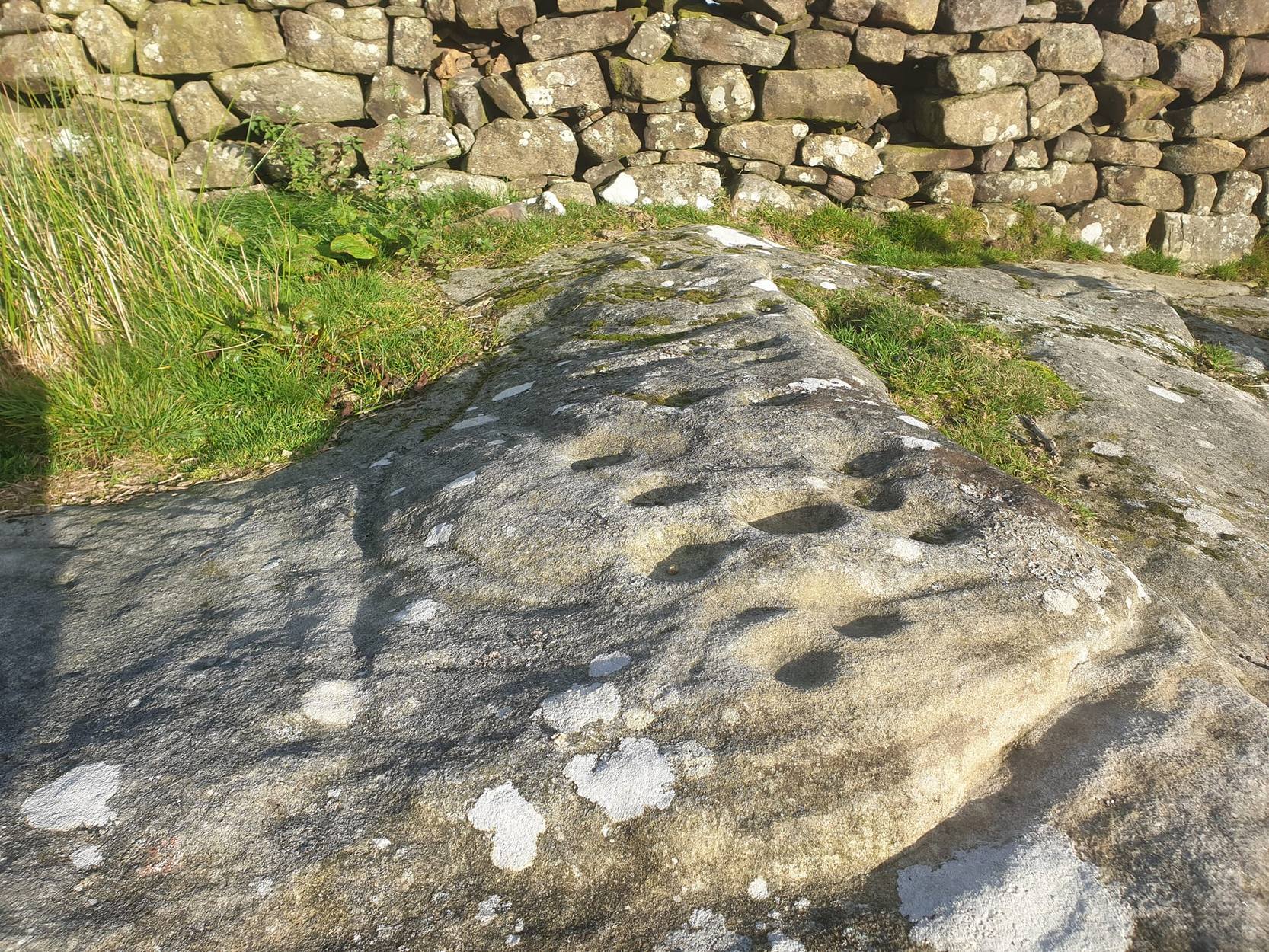
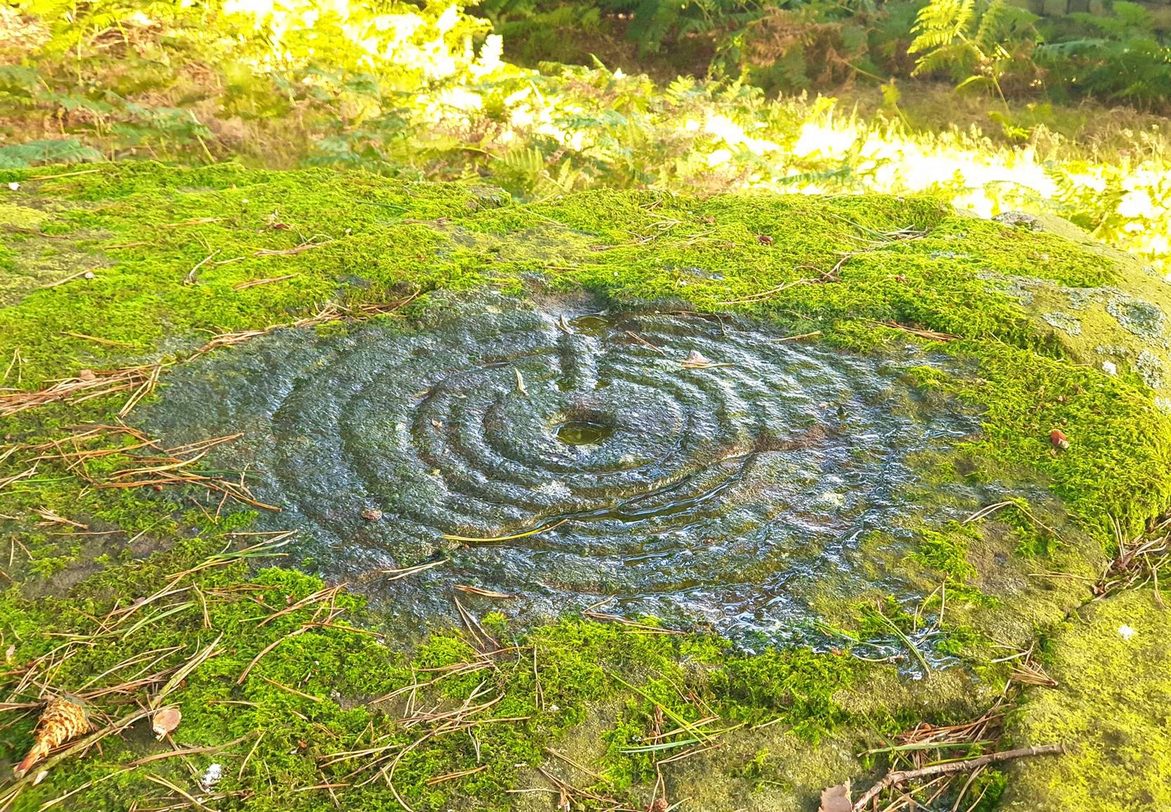
The carving here doesn’t give much clues in any direct sense either. We have an almost arrowhead-shaped rock with a dozen decent cup-marks or so cut along and near its western side; but the notable curiosity here is the small circular cluster of smaller cup-marks dotted in a near circular mass near the middle of the stone.
When Danny, Paul and I came here the other week, the initial impression of this cluster was one of a primitive solar symbol etched onto the rock; but the more we looked, the more it seemed that these small cups appeared to have been arranged in a very rough spiral lay-out. Now I know that spirals are damn rare items in rock art (especially in this part of the world), but the more we looked and then subsequently checked Boughey & Vickerman’s (2003) illustration, the more evident it became. Of course the ‘spiral’ could be merely fortuitous, but I’m not so sure misself. In discussing this with our field archaeologist later, he suggested getting a rubbing of this part of the stone on his next visit.
The stone was first described by the petroglyph explorer Stuart Feather (1964) and later described by the rock art students Boughey & Vickerman (2004), simply as:
“Large, rough grit rock with face sloping SE down into grass at N. About twenty cups to W, with three grooves at N corner and group of about twenty small cups at NE.”
A very intriguing carving. And if you visit here, make sure you check out carving 424 and others in the same field.
References:
- Boughey, Keith & Vickerman, E.A., Prehistoric Rock Art of the West Riding, WYAS: Wakefield 2003.
- Feather, Stuart, “Appletreewick, WR,” in ‘Archaeological Register, 1963’, Yorkshire Archaeological Journal, volume 41, 1964.
Links:
- Eller Edge Rock Art – more notes & images
© Paul Bennett, The Northern Antiquarian