Cross: OS Grid Reference – NS 90135 92660
Also Known as:
- Parkmill
- Pillar Stone of Brath

From Alloa head east along the A907 road and park up at Morrison’s supermarket a half-mile on. From here, keep walking along the same road, but make sure you go on the dirt-track running parallel with the main road, and which runs alongside the field in which this monument is clearly visible. Just make sure you only visit it when the crops aren’t growing (between September through to April is OK).
Archaeology & History
This is a highly impressive monument, but I for one doubt that it has a wholly christian origin… The fact that a stone circle was on the same ridge totally visible a couple of hundred yards away, and a cluster of Bronze Age cairns immediately west, adds to my doubt; along with the sheer size of this thing trying to grab attention to itself. You’ll have to visit it yourself and see what I mean.
The stone was first described in the Old Statistical Account of the area in 1795, and it told:
“About a mile east of the town, there is a large upright stone, 7 feet 4 inches above the surface of the ground. It is three feet broad, and thought to be very deep in the Earth. The old people used to speak of the figure of a man on horseback, which they had seen on it. If any thing of that kind, or letters (as it is said), have been formerly observed, they are now totally effaced.”
However, in a footnote to this entry, it was said that,
“when the adjacent farm was enclosing, upwards of 20 years ago, a ditch was made close to the stone, when many human bones were discovered; which proves that a battle or skirmish had some time or other taken place near that spot; and probably some man of eminence was buried hard by, as it was a common practice of the Picts on such occasions. There are two stones resembling this one, in the neighbouring parish of Alva, at no great distance from the church, but not close to one another. They are both near the foot of the Ochils.”
It seems most probable that this great cross-carved monolith had some relationship to our heathen mythic history—an idea which has been put forward by others historians in bygone times. In Daniel Wilson’s (1851) huge work, he told us:
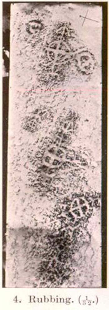
“On ground about half a mile to the east of the town of Alloa, called the Hawkhill, is the large upright block of sandstone sculptured with a cross which is represented in the annexed engraving. It measures ten and a quarter feet in height, though little more than seven feet are now visible above ground. A similar cross is cut on both sides of the stone, as is not uncommon with such simple memorials. During the progress of agricultural operations in the immediate vicinity of this ancient cross, in the spring of 1829, Mr. Robert Bald, C.E., an intelligent Scottish antiquary, obtained permission from the Earl of Mar to make some excavations around when, at about nine feet north from the monumental stone, a rude cist was found, constructed of unhewn sandstone, measuring only three feet in length, and at each end of the cover, on the under side, a simple cross was cut. The lines which formed the crosses were not rudely executed, but straight and uniform, and evidently finished with care, though the slab itself was unusually rude and amorphous. The cist lay east and west and contained nothing but human bones greatly decayed. Drawings of the cross and a plan of the ground, executed by Mr. Bald, are in the possession of the Society of Antiquaries. Here we possess a singularly interesting example of the union of Christian and Pagan sepulchral rites: the cist laid east and west, according to the early christian custom, yet constructed of the old circumscribed dimensions, and of the rude but durable materials in use for ages before the had superseded the aboriginal Pagan creeds.”
")

A few years later there was another account of this cross published in the Proceedings of the Society of Antiquaries, Scotland (1889), echoing much of what Wilson described, telling of the discoveries of many human remains found hereby. And when the Royal Commission (1933) account of the place was written after their inspection team visited the site in 1925, they told:
“This slab…is set up on a knoll about 200 yards south of the main roadway between Alloa and Clackmannan and about midway between the site of the (Hawk Hill) cairn…and that of the (Hawk Hill) stone circle… It is packed round the base with fairly large stones and stands with its broad faces east and west. A cross of Celtic form is incised on both sides, the incisions being about half an inch in depth. On the east face the shaft is made to spring directly from a base, without the intervention of a basic line. The design on the west face is similar, but the shaft here has been almost entirely obliterated by weathering. The slab is 8 feet in height, 2 feet 7½ inches in width at the base, and 9 inches in thickness.”
Notice that the more recent accounts don’t mention the horse carving: an intriguing element which was however mentioned in some early local history works of the place. Indeed, some postulate that this may have Pictish origins. They may be right. As local historian T.C. Gordon (1937), told,
“that the old people of the parish could remember seeing on the soft surface of the stone the figure of a man on horseback.”


On the day I visited this stone I couldn’t make out any carved horse, but it seemed that something may once have been carved near the bottom the western face…perhaps… One writer also suggested that the nearby place-name of Gaberston may have related to this stone cross, with the word literally meaning ‘The Pillar Stone of Brath (Brude),’ which as Mr Gordon said, thus provides “the link between the stone and (the Pictish leader) Brude, and this link is strengthened when we remember that the burn that runs through Alloa is called ‘the Brathy Burn.’”
The possible Pictish motifs of a horseman were mentioned again in a letter from the local County Planning Officer to the Alloa County Clerk in 1971, along with a recommendation that the cross be removed and placed into a museum to prevent further weathering and erosion. Thankfully this suggestion was not followed through and the cross remains where it belongs: in its position in the landscape to beguile and intrigue us over its hidden commemorative past. Long may it remain upon its hill.
A very impressive site indeed…
Folklore
Thought locally to have played a part on an alignment or ley line with a little-known Druid Stone by the roadside in Alloa, the Hawk Hill cairn, and Hawk Hill stone circle to its east. The historian T.C. Gordon (1937) told that the cross marked the site where the Picts fought against the Saxons, saying:
“We know that Finguine, son of Deleroith, died in that battle in 711 AD, and maybe Brude too. A stone cross still marks the place at Hawkhill.”
References:
- Gordon, T. Crouther, A Short History of Alloa, Alloa Advertiser 1937.
- Lothian, James, Alloa and its Environs, Alloa Advertiser 1861.
- Miller, Peter, “Notices of the Standing Stones of Alloa and Clackmanan,” in Proceedings of the Society of Antiquaries, Scotland, volume 23, 1889.
- Royal Commission on the Ancient & Historical Monuments, Scotland, Inventory of Monuments and Constructions in the Counties of Fife, Kinross and Clackmannan, HMSO: Edinburgh 1933.
- Wilson, Daniel, The Archaeology and Prehistoric Annals of Scotland, Sutherland & Knox: Edinburgh 1861.
© Paul Bennett, The Northern Antiquarian


")