It is difficult to assess the precise nature of this megalithic site, sadly destroyed some two hundred years ago. The Royal Commission thinks it may have been a rocking stone, but the legend said of it indicates it to have been associated with a giant prehistoric cairn, although nothing remains nowadays. The site was mentioned briefly in James Patterson’s (1863) huge work on the townships of Ayrshire, where he described the site as “standing upright” and “being in a field on Lodgehouse Farm,” near the village church.
“It stood on three stones, so high that a man could crawl under. It was blasted in 1819 to build houses. The farmer’s wife, it is said, took some antipathy to it, and would not give her husband rest until he consented to have it removed. A person of the name of Jamieson, and an assistant, were employed to blast it, which was accordingly done. When broken up, it filled twenty-four carts. Such was the feeling of sacrilege occasioned by the removal of the stone, that it was observed the farmer’s wife became blind, and continued so for eight years, when she died. Jamieson, who blasted it, never did well afterwards. He drank and went to ruin.”
Serves them right! Additional lore gained from a local lady in the 1870s has one of those all-too-familiar elements to it, speaking of something more substantive.
Folklore
When Archibald Adamson (1875) wrote his fine work on the history of Kilmarnock and district, folklore elements more typical of the Cailleach—whose legends abound in our more northern climes—seemed to have been attached to this missing site. It is worth telling in full:
“After partaking of refreshments in the village inn, and indulging in a chat with the landlord, I retraced my steps to the highway, and in doing so got into conversation with an old lady who was very loquacious and well versed in the lore of the district. Amongst other things, she informed me that once on a time the church of Craigie had a narrow escape of being destroyed by a witch who had taken umbrage at it. It seems that the hag selected a large stone, and having placed it in her apron, flew with it in the direction of the building with the intention of dropping it upon its roof. Her design, however, was frustrated by the breaking of her apron strings, for, upon nearing the object of her spleen, they gave way, and the stone fell with a crash that shook the earth. This accident seemingly so disheartened the carlin that she abandoned the destructive idea and allowed her burden to lie where it fell. The boulder lay in a field near the churchyard wall, and was known as “The White Stane.” It was long regarded with superstitious awe by many; but the farmer on whose ground it lay being of a practical turn of mind, looked upon it with an eye to utility, and had it blasted for building purposes. Strange to relate, when broken up the debris filled twenty-five carts–a circumstance that would lead one to suppose that the witch must have been very muscular, and must have worn a very large apron.”
It is most likely that the witch in this legend originally set off from the Witch’s Knowe, more than 500 yards to the west of the church (and still untouched, despite the mess of the quarrying immediately adjacent). Any further information on this missing site would be greatly appreciated.
References:
Adamson, Archibald S., Rambles round Kilmarnock, T. Stevenson: Kilmarnock 1875.
Paterson, James, History of the Counties of Ayr and Wigton – volume 1, James Stillie: Edinburgh 1863.
Maypole (destroyed): OS Grid Reference – SE 2068 2672
Archaeology & History
As in countless villages and towns across the British Isles, Gomersal also once had its maypole near or at the village centre. We don’t know when the first maypole was erected in the village and many local sites were openly destroyed by rampant christian puritans and similar idiots. It stood not far from the Moor Lane Well and was described by the regional historian H.A. Cadman (1930), who told:
“The Maypole was at the top of Moor Lane and one can imagine the welkin echoing to the very old song:
‘Come lasses and lads take leave of your dads
And away to the maypole hie.
For every fair has a sweetheart there
And the fiddlers standing by.
For Willy shall dance with Jane
And Johnny has got his Joan.
To trip it, trip it, trip it, trip it,
Trip it up and down.’
Yet as with maypoles up and down the land, testosterone-fuelled Springtime fall-outs happened. Mr Cadman told:
“Very often May Day gatherings ended up with fights. Great jealousy always existed between the inhabitants of Great Gomersal, Little Gomersal and Spen. There is a tradition which has been handed down that the last Maypole in this district stood on Liversedge Green. This Maypole was demolished in a fight by the Gomersalians and there is a similar tradition about the Maypole on Cleckheaton Green, so as Mr Frank Peel says, “It is evident that ancient inhabitants of Gomersal were more pugnacious than their neighbours.” I have no evidence when the Gomersal Maypole ceased to exist, but there is abundant evidence to prove that there was one in Gomersal, the proof being that the vane is now in Batley Museum. It is in the form of a fish.”
If anyone has any further information on this important relic, or its history, please let us know.
References:
Cadman, H. Ashwell, Gomersal, Past and Present, Hunters Armley: Leeds 1930.
Maypole (destroyed): OS Grid Reference – TQ 3073 8092
Archaeology & History
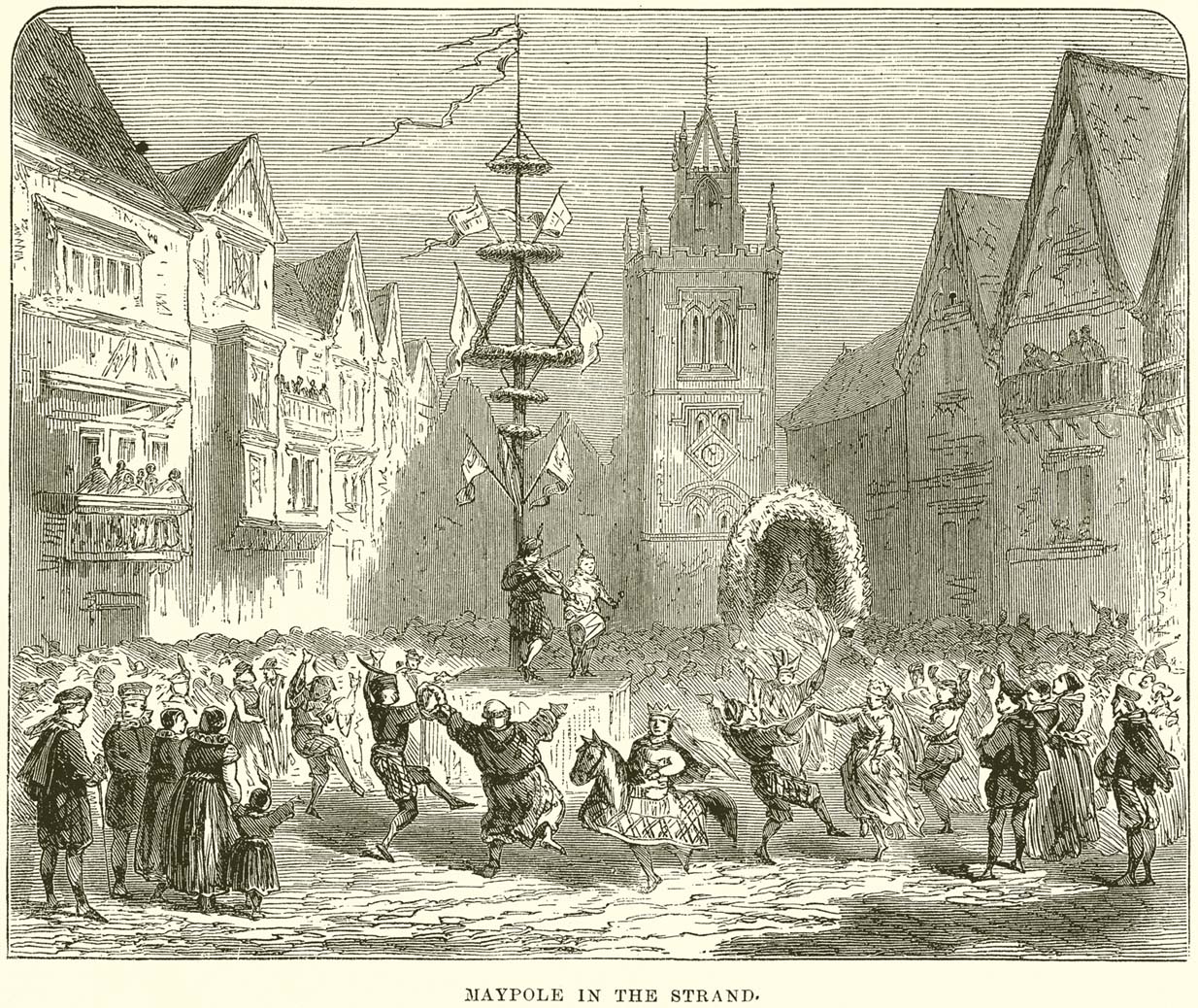
This huge traditional monument was once a sight to behold! It stood close to where an ancient stone ‘cross’ once lived. But—alas!, with the intrusion of the incoming christians bringing a profane ‘religion’ that belongs to countries far from here, its destruction was imposed. They destroyed so many of our ancient monuments with their hatred and ignorance… But thankfully we have some good accounts of this long-forgotten relic of London’s real history.
In A.R. Wright’s (1938) account of it, he called this “the most famous maypole in England” and it stood taller than even the great maypole that’s still raised at Barwick-in-Elmet, in Yorkshire.
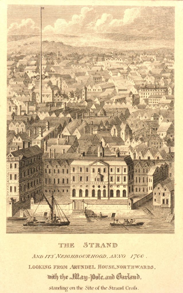
There seems to have been three maypoles on this same site – the first of which was standing before the destruction of Strand’s ancient cross, where local jurisdictions and early village meetings took place. We don’t know the date when the first maypole was erected, but it was shown on a local plan of the area “which Anthony van den Wyngaerde issued in 1543…in front of the old church of St. Mary le Strand, which was demolished in 1549.” According to Mr Hone (1826), it could be found a door or two westward beyond “where Catherine Street descends into the Strand.”
In Edward Walford’s (1878) massive tome, he gave us perhaps the best and most extensive account of the site, telling:
“The Maypole, to which we have already referred as formerly standing on the site of the church of St. Mary-le-Strand, was called by the Puritans one of the “last remnants of vile heathenism, round which people in holiday times used to dance, quite ignorant of its original intent and meaning.” Each May morning, as our readers are doubtless aware, it was customary to deck these poles with wreaths of flowers, round which the people danced pretty nearly the whole day. A severe blow was given to these merry-makings by the Puritans, and in 1644 a Parliamentary ordinance swept them all away, including this very famous one, which, according to old Stow, stood 100 feet high.
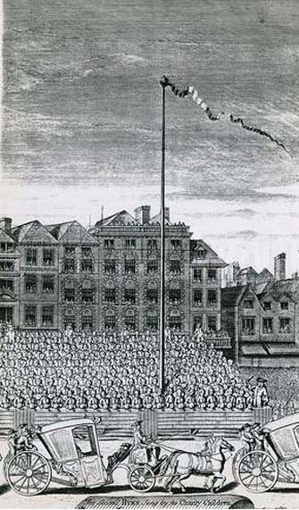
On the Restoration, however, a new and loftier one was set up amid much ceremony and rejoicing. From a tract printed at the time, entitled ‘The Citie’s Loyaltie Displayed,’ we learn that this Maypole was 134 feet high, and was erected upon the cost of the parishioners there adjacent, and the gracious consent of his sacred Majesty, with the illustrious Prince the Duke of York:
“This tree was a most choice and remarkable piece; ’twas made below bridge and brought in two parts up to Scotland Yard, near the king’s palace, and from thence it was conveyed, April 14, 1661, to the Strand, to be erected. It was brought with a streamer flourishing before it, drums beating all the way, and other sorts of musick. It was supposed to be so long that landsmen could not possibly raise it. Prince James, Duke of York, Lord High Admiral of England, commanded twelve seamen off aboard ship to come and officiate the business; whereupon they came, and brought their cables, pullies, and other tackling, and six great anchors. After these were brought three crowns, borne by three men bareheaded, and a streamer displaying all the way before them, drums beating and other musick playing, numerous multitudes of people thronging the streets, with great shouts and acclamations, all day long. The Maypole then being joined together and looped about with bands of iron, the crown and cane, with the king’s arms richly gilded, was placed on the head of it; a large hoop, like a balcony, was about the middle of it. Then, amid sounds of trumpets and drums, and loud cheerings, and the shouts of the people, the Maypole, ‘far more glorious, bigger, and higher than ever any one that stood before it,’ was raised upright, which highly did please the Merrie Monarch and the illustrious Prince, Duke of York; and the little children did much rejoice, and ancient people did clap their hands, saying golden days began to appear.”
A party of morris-dancers now came forward, “finely decked with purple scarfs, in their half-shirts, with a tabor and a pipe, the ancient music, and danced round about the Maypole.”
The setting up of this Maypole is said to have been the deed of a blacksmith, John Clarges, who lived hard by, and whose daughter Anne had been so fortunate in her matrimonial career as to secure for her husband no less a celebrated person than General Monk, Duke of Albemarle, in the reign of Charles II., when courtiers and princes did not always look to the highest rank for their wives.
…Newcastle Street, at the north-east corner of the church of St. Mary-le-Strand, was formerly called Maypole Alley, but early in the last century was changed to its present name, after John Holles, Duke of Newcastle, the then owner of the property, and the name has been transferred to another place not far off. At the junction of Drury Lane and Wych Street, on the north side, close to the Olympic Theatre, is a narrow court, which is now known as Maypole Alley, near which stood the forge of John Clarges, the blacksmith, alluded to above as having set up the Maypole at the time of the Restoration.
As all earthly glories are doomed in time to fade, so this gaily-bedecked Maypole, after standing for upwards of fifty years, had become so decayed in the ground, that it was deemed necessary to replace it by a new one. Accordingly, it was removed in 1713, and a new one erected in its place a little further to the west, nearly opposite to Somerset House, where now stands a drinking fountain. It was set up on the 4th of July in that year, with great joy and festivity, but it was destined to be short-lived. When this latter Maypole was taken down in its turn, Sir Isaac Newton, who lived near Leicester Fields, bought it from the parishioners, and sent it as a present to his friend, the Rev. Mr. Pound, at Wanstead in Essex, who obtained leave from his squire, Lord Castlemaine, to erect it in Wanstead Park, for the support of what then was the largest telescope in Europe, being 125 feet in length. It was constructed by Huygens, and presented by him to the Royal Society, of which he was a member. It had not long stood in the park, when one morning some amusing verses were found affixed to the Maypole, alluding to its change of position and employment. They are given by Pennant as follows:
“Once I adorned the Strand,
But now have found
My way to Pound
On Baron Newton’s land;
Where my aspiring head aloft is reared,
T’ observe the motions of th’ ethereal Lord.
Here sometimes raised a machine by my side,
Through which is seen the sparkling milky tide;
Here oft I’m scented with a balmy dew,
A pleasant blessing which the Strand ne’er knew.
There stood I only to receive abuse,
But here converted to a nobler use;
So that with me all passengers will say,
‘I’m better far than when the Pole of May.'”
Along with the Strand Cross, this old maypole would have been on the ancient ley (not one of those ‘energy lines’ invented by New Age fantasists) that was first described first by Alfred Watkins (1925)—running from St. Martins-in-the-Field to St. Dunstan’s in Fleet Street. The alignment and maypole was subsequently described in greater detail in Devereux & Thomson’s (1979) work on the same subject, and again by Chris Street. (2010)
The nature of the maypole (and the nearby cross, it has to be said), may have been representative of an omphalos in early popular culture (before the christians of course)—which would put the original ritual function of the place far far earlier than is generally considered. This is something that Laurence Gomme (1912) propounded in one of his London works and cannot be discounted.
This fascinating looking carving (in my personal Top 10 of all-time favourites cup-and-rings in the UK!) was unfortunately destroyed sometime between 1918 and 1920. A huge pity, as the design on the rock is almost unique in its ‘linear’ system of cups running a considerable length across the surface of the stone (like the similar design found at Old Bewick in Northumberland).
Wilson’s 1851 drawing of the Witches’ StoneSimpson’s 1866 drawing of the Witches Stone
Shown first of all on Kirkwood’s Environs of Edinburgh map in 1817 (above), this legendary rock was found amidst a cluster of other cup-and-ring stones at Tormain (some are still there) and was initially said by Daniel Wilson (1851) to have been the giant capstone of a cromlech that once stood here, but whose structure had fallen away. This idea is implied in the earliest drawing we have of the stone in Wilson’s magnum opus (above); Sir J.Y. Simpson (1867) gave us a similar impression with his drawing a few years later. But upon visiting the Witches Stone just as his book was going to the press, Mr Wilson visited the site and proclaimed that he “altogether doubted if they are the remains of a cromlech”, and what rested here were more probably just fascinating geological remains, with even more fascinating carvings on top!
In the years that followed Wilson’s initial description, the Witches Stone was visited and described by a number of eager antiquarians. Simpson (1867) gave us a quite revealing account, telling:
“On the farm of Bonnington, about a mile beyond the village of Ratho…are the remains of ‘this partially ruined cromlech’…with the capstones partially displaced, as if it had slid backwards upon the oblique plane of the huge stones or stone which still supports it. Two or three large blocks lie in front of the present props. Its site occupies a most commanding view of the valley of the Almond, and of the country and hills beyond. The large capstone is a block of secondary basalt or whinstone, about twelve feet long, ten in breadth and two in thickness. Its upper surface has sculptured along its median line a long row of some twenty-two cup-cuttings; and two more cup-cuttings are placed laterally: one, half a foot to the left of the central row and at its base; the other, two feet to the right of the tenth central cup and near the edge of the block. The largest of the cups are about three inches in diameter and half an inch in depth; but most of them are smaller and shallower than this…”
A few years later another early petroglyph authority, J. Romilly Allen (1882), visited the Witches Stone and found “an Ordnance bench mark (had been) cut on the stone itself”! He then continued with his own description of this once-important megalithic site:
“The Witch’s Stone is a natural boulder of whinstone, rounded and smoothed by glacial action, whoso upper surface slopes at an angle of about 35° with the horizon. The length of the sloping face is 8 feet and at the top is a flat place 2 feet wide. The breadth of the stone is 11 feet 3 inches at the upper end, and 4 feet at the lower end. The thickness varies from 2 to 3 feet. The highest part of the stone is 6 feet 6 inches above the ground, and the lowest 1 foot 6 inches. It rests on what has originally been a portion of the same boulder, but is now a mass of whinstone broken up into several fragments, which serve as supports to prop up the stone above. Viewed from the north side the whole presents the appearance of a cromlech, the upper stone forming the cap, and the disintegrated portion below the supports. This notion, however, will be clearly seen to be erroneous on looking at it from the opposite side, as shown on the accompanying sketch…where the crack separating the two portions of the boulder is very apparent… The sculpturings consist of twenty-four cups varying in diameter from 1½ to 3 inches. Twenty-two of these cups are arranged in an approximately straight line along the sloping face of the stone, and divide it into two almost equal parts. The two remaining cups lie, one 7½ inches to the left of the lowest cup of the central row, and the other 2 feet 3 inches to the right of the ninth cup up the stone… The field in which the Witch’s Stone is situated is called “Knock-about.” The sloping face of the stone has been much polished by the practice of people climbing on to the top and sliding down. Some of the cups are almost obliterated in consequence. The stone forms a very prominent feature in the view, and must always have attracted attention from its peculiar shape.”
Some twenty years after Allen, the megalithomaniac Fred Coles (1903) came and checked the Witches Stone out for himself and, as happens, had a few additional things to say about the place:
“Although this huge boulder and its cup-marks have been more than once figured and described, I found, on a close examination of the broad surface of the Stone, that none of the illustrations showed the cup-marks in their exact relation to each other, nor in their true relation to the contour of the Stone. The drawing shown above…was made after a careful measurement by triangulation of the Stone; and it is claimed to be the first that shows that the cups, two and twenty in number, are not disposed in one continuous line, but that thirteen follow each other from the high south edge of the stone for a distance of exactly 6 feet, and nine others lie a few inches to the west, occupying a space 3 feet long of the overcurving edge of the north end. It is further shown that, at a point 2 feet 3 inches west of the ninth cup-mark, there is another one quite as large as the largest in the rows near the middle of the Stone. The south edge (A B) has slipped a little down from its original height, the boulder being frost-split horizontally; its height there above ground is 8 feet. The northern and narrower end is about 2 feet above ground, and does not touch the ground, as it rests upon its lower portion, beyond which it projects a few inches. The cup-marks run due north.”
Fred Coles 1903 drawing
If the Witches Stone was in fact a natural outcrop stone and not a cromlech, this very last point telling that “the cup-marks run due north” probably had much greater importance than a mere compass-bearing to the people who etched this carving. For in pre-christian religious structures across the northern hemisphere, north is commonly representative of death and the land of the gods. In magickal rites “it is the place of greatest symbolic darkness,” as neither sun nor moon ever rise or set there. Additionally, north is the place where, in shamanic traditions, the heavens are tied to the Earth: the cosmic axis itself that links heaven, Earth and underworld. In early neolithic traditions this mythic structure was probably endemic. Whether its magickal relevance was intended here, at this stone, we will probably never know…
Folklore
Folklore tells that the Witches Stone was one of the sites used in magickal rites by the Scottish occultist, Michael Scot. J.R. Allen’s (1882) description of “the sloping face of the stone has been much polished by the practice of people climbing on to the top and sliding down,” may relate to folk memory of fertility rites once practiced here, as found at similarly carved rocks in the UK and across the world.
McLean, Adam, The Standing Stones of the Lothians, Megalithic Research Publications: Edinburgh no date (c.1978).
Morris, Ronald W.B., The Prehistoric Rock Art of Southern Scotland, BAR: Oxford 1981.
Royal Commission on the Ancient & Historical Monuments of Scotland, Inventory of Monuments and Constructions in the Counties of Midlothian and West Lothian, HMSO: Edinburgh 1929.
Simpson, James, Archaic Sculpturings of Cups, Circles, etc., Upon Stones and Rocks in Scotland, England and other Countries, Edmonston & Douglas: Edinburgh 1867.
Carlie Craig is the tree- covered cliff, centre of photo
If you’re coming from Blairlogie, a half-mile west of the village, take the B998 road to the university, but turn right up the first road that runs uphill into the trees. But if you’re coming from Stirling or Bridge of Allan, keep your eyes peeled for the barely visible B998 at the crossroads and go up the hill, and along, for a good mile, below the Uni, past the factory, then up the small road on your left. Up this road go past the church another 100 yards and you’ll see the derelict ruins of Logie Kirk on your right. Right above the ruin you’ll see the tree-lined cliff immediately behind. This is the Carlie Craig!
Folklore
Carlie Craig on the 1862 map
The tree-covered Carlie Crags above the old ruined church and graveyard of Logie Kirk immediately below (thought to have been built in 1684) has long been associated with legends of old witches. Deriving its name from ‘carlin’, a witch or old woman (cailleach), the Crags were traditionally the place of heathen rites (authentic ones, not your plastic pagan types). In David Morris’ (1935) essay on the local township, he told the common story that “an elder in Logie Kirk was of the opinion that the Carla’ Craig…was haunted.” At the end of the 19th century, Morris remembered a local lady known as ‘Ailie’, who was said by many old folk to be the traditional “witch of Logie.”
“Sickly children were brought to her for her blessing. Occasionally people came from as far as Stirling on this errand. Her method of giving the blessing was to blow her breath on the child, and this was supposed to ward off evil. It was also said that anyone buried in Logie Kirkyard on the first day of May, Hallowe’en, or other days of that kind, without her blessing, would not rest in his grave…”
Another legend told that,
“around 1720 witches were believed to rendezvous with the Evil One (i.e. the devil) who would appear in the form of a large black dog.”
A lengthier account of the belief in witchcraft and animistic pre-christian rites above the crags was told by Charles Rogers (1853):
“About the second decade of last century, there lived in the parish of Logie several ill-favoured old women, to whom the reputation of witchcraft was confidently attached. They were believed to hold nocturnal dialogues and midnight revels with the Evil One, and Carlie Crag was regarded as one of their places of rendezvous. Satan, though he was believed to appear to them in various forms, was understood, in his interviews with the dreaded sisterhood, to appear most frequently in the aspect of a large shaggy dog, in which form it was alleged he had repeatedly been seen by the minister. An elder of the kirk had been returning of an evening from a shooting excursion among the hills, with a trusty musket, which he had picked up some years before on the field of Sheriffmuir, and discovering on the top of Carlie an animal realizing the description of the Satanic mastiff, resolved to try upon it the effects of a shot. He knelt down cautiously near the foot of the crag, and after ejaculating a short prayer, and slipping into his musket a silver coin, fired with trembling heart but steady aim. His victim, evidently shot dead, tumbled to the base, and the delighted and astonished elder lost no time in personally communicating to the minister the success of his wonderful adventure. Though not a little superstitious, the minister was somewhat sceptical as to the mysterious dog being really dead. He however agreed to accompany his elder next morning to the foot of the crag to inspect the carcase; but on reaching the spot, they found the remains of no shaggy dog or evil genius, but the lifeless form of the beautiful pet goat of a poor and aged woman, a much respected parishioner. The minister and elder both shed tears. The wicked dog still lived, the innocent goat had perished. The elder however took credit to himself for his good intentions and valorous intrepidity ; and the minister deemed it proper to improve the subject in his pulpit prelections on the following Sabbath. Discoursing on the subject of resistance to the Devil, he remarked, that the Evil One might assume numerous shapes and forms; that he went about as a roaring lion was declared in the Word, but he might take to himself various other aspects. He might even appear as a black colley dog.” But whatever form he may assume,” added the minister, ” he cannot be overcome or destroyed by powder and shot. There is a gun, however, that will shoot him, and it is this — it is the Bible. Shoot him then, every one of you, with this gun, and he shall be shot.”
Whether the vicar’s biblical superstitions were adopted by local people—who were so much more used to the living animism of landscape and natural cycles—is questionable. The crag is a fine site for ritual magick and its associative devil-lore probably derives from Pictish shamanistic practices, remains of which are evident across the Scottish hillls and northern England, where they survived for some considerable time…
References:
Morris, David, B., “Causewayhead a Hundred Years Ago”, in Transactions of the Stirling Natural History and Archaeological Society, 1935.
Roger, Charles, A Week at Bridge of Allan, Adam & Charles Black: Edinburgh 1853.
Watson, Angus, The Ochils – Placenames, History, Tradition, Perth & Kinross District Libraries 1995.
Legendary Stone (destroyed): OS Grid Reference – NT 058 865
Archaeology & History
Travelling along the old road between Crossford and towards Cairneyhill, on the right-hand (north) side, there was until recently a huge boulder, described by the folklorist J.E. Simpkins (1914),
“Its horizontal dimensions above ground are diagonally 18 feet by 21 feet; its vertical height above ground 5 feet… I estimate its weight at nearly 200 tons.”
The stone was proclaimed by 19th century geologists to be a glacial deposit from the upper region of the Forth (the nearest mountain region possessed of this type of stone); although our old petroglyph writer, Sir James Simpson, postulated the Witch’s Stone to be “of meteoric origin.”
But like oh so many old sites with heathen tales attached, the stone was destroyed by a local farmer on 7 February, 1972. The following interesting notes were made in a Crossford & Cairneyhill School log-book, describing its destruction:
“The local farmer blasted the “Witch’s Stone”, situated about 300m East of school at 2.30 this afternoon. Children vacated both buildings and sheltered at West End of main building. All windows were opened. Police informed that further operations of this nature will be carried out at weekend.”
A week later on February 14, all “remains of “Witch’s Stone” removed by blasting at 3pm today.”
On the other side of the road from our Witch’s Stone was another boulder, this time known as the Cadger’s Stone, said by Beveridge (1888) to have got its name,
“from the circumstance of its having formed a landmark for the ‘cadgers’, or itinerant merchants, who were wont to rest themselves and their ponies whilst they deposited for a short while their burdens on the stone.”
The earliest OS-map of the region in 1856 shows neither of these stones, but does highlight a Capel Stane, or Stone of the Horse, very close by.
Folklore
The stone was obviously of some traditional importance to local people in pre-christian times. David Beveridge (1888) described the position and creation myth of the Witch’s Stone as follows:
“On our right a singular-looking stone of blue limestone appears in a field, and is known as the Witch’s Stone, the popular legend being that a notable witch in this neighbourhood found it on the seashore, and that after she carried it some distance in her apron, the string of the latter broke, and the stone has since continued to lie in the place where it fell. “
A few years after this, the folklorist J.E. Simpkins (1914) wrote:
“The legend connected with this boulder is, that a witch wishing to bestow a valuable gift on the Pitfirrane family, resolved to present to them a cheese-press. With that view, she lifted this boulder and carried it some distance in her apron, but owing to its excessive weight the apron-strings broke and the stone fell to the ground, where it has remained ever since.”
If anyone knows anything more about this old stone, or has any old photos of the fella, please let us know!
References:
Beveridge, David, Between the Ochils and Forth, William Blackwood: Edinburgh 1888.
Simpkins, John Ewart, Examples of Printed Folk-lore Concerning Fife, with some Notes on Clackmannan and Kinross-shires, Sidgwick & Jackson: London 1914.
Until we’ve isolated this site, it’s difficult to suggest an age for it. It’s an all-but forgotten grave of some sort, last mentioned by John Clough (1886) in his rare work on Steeton township. Although the folklore indicates some medieval date here, the site may have been a prehistoric tomb, as it was located in the same valley a mile east of another little-known prehistoric burial at Crosshills. Mr Clough wrote the following of the site:
“Until AD 1790 the road to Kildwick would be down Pot Lane and past ‘The Lion’. Near a field, now called Nanny Grave Hill; there were four land ends; there are three lane ends yet; there was what i’s called Devil’s Lane, the lanes towards Eastburn and Steeton, and Wood Street… The junction of these four lane ends is the scene of one of Steeton’s tragedies. At this place is buried a suicide called Nanny, with “a stake in her inside.” Some people point out the mound under which she’s buried. When the suicide took place isn’t known, but it would certainly not occur later than the 17th century.”
But there are no records telling of the said ‘nanny’ and her death, nor archaeological accounts of any excavations hereby. The epithet nanny is sometimes used in northern counties to mean a witch, and although we have no remaining lore telling of such a character, the old name Devil’s Lane certainly infers some pre-christian or supernatural history hereby, common to many ancient burial mounds throughout Britain and across the world. Also a burial at an old crossroads is another heathen indicator; and the legend of the body having “a stake in her inside” is highly suggestive of further archaic death rituals, fixing the spirit of the dead at the site to prevent transmigration of any form, effectively ending the lineage of shaman or other heathen priestess. Any further information about this site would be most welcome.
References:
Clough, John, History of Steeton, S. Billows: Keighley 1886.
Maypole (destroyed): OS Grid Reference – SE 0458 9121
Redmire’s ancient Oak
Archaeology & History
As with many of Britain’s old maypoles, the one at Redmire has long since disappeared and no local in the 20th century appears to have had any memory of it. However, it was mentioned in Victorian times and described in McGregor’s (1989) fine history work on the village:
“At one time, somewhere on the Green, stood a maypole which was destroyed by lightning. I never heard the memory of it recalled during my early life, but it is mentioned in their books by both Barker and Bogg. The remnants of it appear to have been there in 1850 or 1852, as Barker, writing at that time says, ‘A maypole, rare in Yorkshire, stands on the Green. It was shivered to pieces by the electric fluid, during a thunderstorm, in the summer of 1849. This poor maypoles catastrophe would have been regarded by the old Puritans as a direct and visible manifestation of the wrath of heaven at such a heathenish practice.’ Redmire, as we know, took pleasure in dancing in the 19th century, and continued to do so, especially after the building of the Town Hall…”
When Edmund Bogg came here at the end of th 19th century, he saw “the base of the ancient maypole…near to, a twisted and ancient oak” whose ancient branches were being held upright by large wooden posts. This sacred oak itself was said to “still cast its shade over a small spring of water.” Unfortunately I ‘ve found no more about this lost pagan relic…
References:
Barker, W.G.M.J., The Three Days of Wensleydale, Charles Dolman: London 1854.
Bogg, Edmund, Wensleydale and the Lower Vale of Yore, E. Bogg: Leeds n.d. (c.1900)
McGregor, Isabelle, Redmire – A Patchwork of its History, privately printed: Redmire 1989.
From Dunkeld travel southeast on the A984 road to Caputh and after about 1½ miles, set back a few yards from the road amidst the trees below the Newtyle Quarries (whose mass of slate and loose rocks cover the slopes), you’ll see these two large monoliths. There’s nowhere to park here, but there’s a small road a coupla hundred yards before the stones aswell as a space to park on the verge by the side of the road a few hundred yards after them. Take your pick!
Archaeology & History
When we visited these two tall standing stones a few weeks ago, guerilla archaeologist Hornby and I were a little perplexed at the state of these stones, wondering whether they were a product of the fella’s who dug the quarries above here, or whether they were truly ancient. It seems the latter is the consensus opinion!
They were described by the great Fred Coles (1908) in one of his lengthy essays on the megaliths of Perthshire, where he thought the two stones here were all that remained of a stone circle that once stood on the flat, above the River Tay, but whose other stones “were destroyed in the making of the road” which runs right past here. Not so sure misself! He told that,
“An old cart-track runs up between the stones, leading from the main road…up to the quarry. The mean axis of the two stones runs N 13° W and S 13° E (true), and although their broader faces do not point towards the centre of a circle on the west, it is certainly much more probable that the other stones were on this side, the lower and flatter ground, than on the east, where the ground slopes and is more broken and rough.
“Both stones are of the common quartzose schist, but they differ considerably in shape. A is 6 feet 7 inches high at the north corner, but only 4 feet 10 inches at the south, and its vertical height at the east is only 3 feet. The basal girth is 13 feet 3 inches, and in the middle 15 feet 9 inches. The broad east face measures 5 feet. Stone B is level-topped and 5 feet in height; it has a basal girth of 12 feet 4 inches, and at the middle of 11 feet 8 inches. Its two broad faces are of the same breadth.”
Little else was said of the two stones for many years and, to my knowledge, no real excavation has been undertaken here. But when Alexander Thom (1990) visited the site he found that,
“This two stone alignment showed the midsummer setting sun. The south stone may possibly, by itself, have shown the setting Moon at major standstill.”
Aubrey Burl’s description of the stones was succinct and echoed much of what Coles had said decades earlier, telling:
“Two very large stones stand only 9 feet (2.7m) apart in an unusually closed-in environment for a Perthshire pair. The ground rises very steeply to the east. To the west the stones overlook the valley of the River Tay.
“Both are of local quartzoze schist and are ‘playing-card’ in shape. As usual it is the westernmost stone that is taller, 7ft 2in (2.2m) in height. Its peak tapers almost to a point. Conversely, its partner is flat-topped and only 4ft 9in (1.5m) high. The pairing of such dissimilarly shaped stones has led to the interpretation of them as male and female personifications.”
Alex Thom’s groundplanBack of the smaller stone
Burl’s latter remark thoughtfully recognises that such animistic qualities are found in many other cultures in the world and this ingredient was also an integral part of early peasant notions in Britain; therefore such ingredients are necessities to help us understand the nature and function of megalithic sites. We must be cautious however, not to fall into the increasingly flawed modern pagan notion of such male and female ‘polarizations’, nor the politically-correct sexist school of goddess ‘worship’ and impose such delusions upon our ancestors, whose worldviews had little relationship with the modern pagan goddess fallacies, beloved of modern Press, TV shows and pantomime festival displays.
Folklore
In Elizabeth Stewart’s history of Dunkeld, she narrates the tale told by an earlier historian who told that,
“these two upright stones at the Doo’s Nest, but says they are supposed to mark the graves of two Danish warriors returning from the invasion of Dunkeld.”
References:
Burl, Aubrey, From Carnac to Callanish, Yale University Press 1993.
Coles, Fred, “Report on Stone Circles Surveyed in Perthshire – Northeastern Section,” in Proceedings of the Society of Antiquaries, Scotland, volume 42, 1908.
Stewart, Elizabeth, Dunkeld – An Ancient City, Munro Press: Perth 1926.
Thom, A., Thom, A.S. & Burl, Aubrey, Stone Rows and Standing Stones – 2 volumes, BAR: Oxford 1990.
From the lovely village of Summerbridge (near Pateley Bridge), go up the steep Hartwith Bank road, going straight across at the crossroads for another few hundred yards, passing the old tombs of Graffa Plain on your right…and they’ll start appearing on your left-hand side (west). Do not go into the expensive National Trust car-park. Instead (if you’ve already gone too far), about 100 yards before the Car Park you’ll find a small dirt-track on your left a short distance away. But if you drive past the rip-off car park, another 100 yards on there’s another spot where you can easily park up on the right-hand side of the road. Then cross the road and follow y’ nose…
Archaeology & History
The OS grid reference given above is an approximation — for obvious reasons. This is a huge area that’s covered by Britain’s finest natural megalithic features, obviously sculptured by Nature Herself — though many are the historians who sought to give Druids the credit here. God knows how! The area over which these magnificent rock sentinels live covers some 60 acres and is some 1000 feet above sea level. The view from the hill around which the encircling parade of rocks guards is excellent, allowing our eyes to catch focus on the distant lands of Whernside, Simon’s Seat, York Minster, the Cleveland Hills and Kilburn’s white horse. It’s quite a view.
Easternmost Rocking StoneIdol Stone (Godfrey Higgins 1826)
But this tends to be overlooked when you first visit the place, as the rocks which surround and walk alongside you overwhelm with impressions not encountered before. To those with spirit, you’ll be bouncing and running all day here, clambering upon rocking stones, jumping between dodgy gorges that await falls, and just aching to climb pinnacles that deny you. But then, if you need the selfishness of silence, this arena will only grant such solace when the rains are about, or dense fog and low cloud keeps others from this haunting amphitheatre. And it’s not surprising… The mass of rocks contort into the most beautiful and curious simulacra, which would not have gone unnoticed, nor deemed unimportant in the sacred landscape of our ancestors…
Brimham Rocks have been written about since the 17th century, though they didn’t receive the serious attention of outsiders until the 19th, when numerous Victorian writers — from antiquarians and geologists, to archaeologists and Druids — got to hear about the place. And by the beginning of the 20th century, a veritable mass of articles had been written in journals and travelogues of all persuasions! These quiet Yorkshire Rocks had become truly famous!
Brimham Rocks (Walbran 1856)Old Woman and her consort
A lengthy essay was written in the distinguished archaeology journal of its time, Archaeologia, by northern historian Hayman Rooke (1787), who thought that some of the rocks here had been tampered with by the druids; with the legendary Cannon Rock in particular possessing oracular properties. The site as a whole was, he posited, a temple for Druids in ancient days. Certainly the place would have been deemed as sacred, whether by the druids or our more remote neolithic and Bronze Age ancestors.
Harry Speight & his mates, c.1890
In Harry Speight’s magnum opus, Nidderdale (1894), he described these rocky giants as best as he could, admitting as others before and since, that no mere words can convey the impression that only a personal encounter liberates, saying:
“The Brimham Rocks are among the greatest natural wonders of Yorkshire, and many have been the theories from time to time advanced as to the cause of their extraordinary aspects… The resemblances to natural and artificial objects are most striking. There we have the Elephant Rock, the Porpoise Head, the Dancing Bear (a very singular, naturally-shaped specimen), the Boat Rock, showing the bow and stern completely, etc. Then there is the great Idol Rock, a most mysterious-looking object, of almost incredible size and form. It is a perfectly detached block, fully twenty feet high, weathered along face joints into three roughly circular pieces, each from 40 to 50 feet in circumference, piled one above the other; the whole mass, weighing by estimation over 200 tons, being poised on a pyramid 3½ feet in diameter; the pivot itself supporting this immense column having a diameter of barely 12 inches.
“East of the guide’s house are the famous Rocking Stones, consisting of a group of four rocks, which were discovered to be movable in the year 1786. The two on the west side weighing approximately 50 and 25 tons, require but little force to vibrate, while those on the east side, though much smaller are not so well poised and do not move readily. Each of the larger stones has a basin-like cavity on the top, and a kind of knee-hole open to the north, said to be the work of Druids. Close to the Rocking Stones are the appropriately-named Oyster-shell Rock, and the Hippopotamus’ Head. Turning now some thirty yards north of the Idol Rock we ascend Mount Delectable, where is the agreeable Courting or Kissing Chair, happily at not too close quarters with the above Hippopotamus’ Head and Boar’s Snout. The Chair consists of a single seat, but why it should be so called, I had better leave the amorous lover to solve. West of these is the more sober Druid’s Reading Desk, with its church-like lectern on a stout stone base. The we come to the Lover’s Leap, a gigantic and abrupt face of beetling crag, weathered to the west, and rising to a height of 60 to 70 feet, with three immense fragments balanced in a very remarkable manner at the summit. The rock is in tow principal sections, and an iron hand-rail has been fixed across the chasm to enable visitors to look down from the top. Further south are the Frog and Tortoise Rocks, the latter presenting from one point of view a capital resemblance to a tortoise creeping up the face of the crag towards the imaged frog. A little below this is a good imitation of a cannon, projecting from the edge of the cliff. In addition to these singular resemblances there are many others which the guide points out, such as the Yoke of Oxen, Mushroom Rocks, Druid’s Oven, Dog’s Head, Telescope, and the curiously perforated Cannon Rock, etc.”
In a later work, Speight (1906) also mentioned the existence of a Druid’s Circle some 300 yards west of the main natural temples, but this site appears to have been destroyed. Thankfully the large standing stone on Hartwith Moor, a mile to the south, can still be found upright…
Folklore
Idol Stone (Hargrove 1809)
In folklore, there’s little surprise this place was held by just about every 18th and 19th century historian as a ‘druidic site.’ But more interesting – in the light of Paul Devereux’s (2001) work on acoustic archaeology – is what Edmund Bogg (c.1895) said of these huge contorted stones:
“In bygone days these immense stones were supposed to be the habitation of spirits. The echo given from the rocks was said to be the voice of the spirit who dwelt there, and which the people named the Son of the Rocks. From a conversation we had with the peasantry not far from here, it seems the ancient superstition had not yet fully disappeared.”
This is precisely the notion of spirit given to rocky places elsewhere in the world, where the very echo was perceived as the ‘voice of the rocks’. Meditate on it a bit, in situ. (a fine summary of this notion and its implications — which has crept into archaeology of late — can be found in Paul Devereux’s work, Stone Age Soundtracks)
One of Brimham’s southwestern rocks was known as the Noon Stone when Mr Rooke (1787) came here. There are many stones with this name scattering Yorkshire and other northern counties, each with the same mythic background: that the sun casts a shadow from it at midday to indicate the time of day. Of this Noon Stone Mr Hooke also told us that,
“On Midsummer Eve fires are lighted on the side. Its situation is apposite for this purpose, being on the edge of a hill, commanding an extensive view. This custom is of the most remote antiquity.”
On the very southern edge of Brimham’s Rocks (some might say beyond their real border) is the Beacon Rock — and it is aptly named: as in the year 1887 on the day of Queen Victoria’s Jubilee, a great beacon fire was lit here, signalling to others in the distance. Its title however, pre-dates Victoria’s Jubilee, though we don’t know how far back in time it goes…
…to be continued…
References:
Bogg, Edmund, From Eden Vale to the Plains of York, James Miles: Leeds c.1895.
Devereux, Paul, Stone Age Soundtracks: The Acoustic Archaeology of Ancient Sites, Vega: London 2001.
Grainge, William, The History and Topography of Harrogate and the Forest of Knaresborough, John Russell Smith: London 1871.
Harrison, William, A Descriptive Account of Brimham Rocks in the West Riding of Yorkshire, A. Johnson: Ripon 1846.
Michell, John, The Earth Spirit: Its Ways, Shrines and Mysteries, Thames & Hudson: London 1975.
Michell, John, Simulacra, Thames & Hudson: London 1979.
Rooke, Hayman, “Some Account of the Brimham Rocks in Yorkshire,” in Archaeologia journal, volume 8, 1787.
Speight, Harry, Nidderdale and the Garden of the Nidd, Elliot Stock: London 1894.
Speight, Harry, Upper Nidderdale, with the Forest of Knaresborough, Elliot Stock: London 1906.
Walbran, John Richard, A Guide to Ripon, Fountains Abbey, Harrogate, Bolton Abbey, etc, Johnson: Ripon 1856.
")
")
sm")
")


")


")