Standing Stones (destroyed): Grid Reference – G 915 605
Archaeology & History
Field-notes collected by Oliver Davies described there being “two standing stones, side by side,” at the coordinate given here. In Lacy’s Archaeological Survey (1983), he told that the larger and southernmost of the monoliths stood 5’10” high, with its companion being just 3 feet tall. All remains of these stones have apparently vanished.
References:
Lacy, Brian, Archaeological Survey of County Donegal, DCC: Lifford 1983.
From East Morton village, take the moorland road, east, and up the steep hill. Where the road levels out there’s a right turn, plus (more importantly!) a trackway on your left which leads onto the moor. Go up here, past the top of the tree-line; on for another 100 yards or so, then turn left into the heather. You’ll notice the upright stone from the path, even if the heather’s deep. Check it out!
Archaeology & History
Todmoor Stone – looking eastTodmoor Stone – looking south
Nowt’s been said of this stone elsewhere — probably cos it’s in that halfway height between being classed as an authentic monolith, and that other of ‘dubious status’ (hence the reason I’ve highlighted this in inverted commas!). But an additional reason that this three-foot-tall stone needs describing is the close association it has with cup-and-ring stones very close by; along with some previously unrecognised prehistoric walling and at least one Bronze Age cairn some twenty yards to the north. We even find two distinctly archetypal ‘standing stone’ characters laid down in the heather 10 yards to the north, more than 4-feet long. It’s a good looking stone and has a chunkier upright bedfellow in the heather some twenty yards to the west. Along with the adjacent prehistoric remains here, the stone’s worth checking out!
The word Todmor was earlier spelt as ‘Todmerstones’ (1849) and is thought to relate to it being, in some form or another, ‘the boundary stones of the fox/es’. The nearest boundary line is about 100 yards west of here.
References:
Smith, A.H., The Place-Names of ther West Riding of Yorkshire – volume 4, Cambridge University Press 1961.
Stone Circle (destroyed): OS Grid Reference – SP 470 464?
Also Known as:
Ringstone Well
Archaeology & History
In 1239 CE we find records of a field-name site called “Ringstoneswelle.” Although the place-name writer Margaret Gelling (1954) initially ascribed this as the watering-place of some dood called Hringstan, it is in fact the only record that I’ve found of a “stone circle by a well” in the village. This etymological root is confirmed in A.H. Smith’s English Place-Name Elements (vol.1, p.265) as a probable stone circle.
Folklore
There is also the curious field-name legend of a place in Cropredy called Kirk or Church Piece, where a christian church was being built, but in the morning all the stones had been uprooted & moved back from whence they came. This happened several times according to the folktale – a story that has with all the hallmarks of a megalithic site. (see Grinsell’s Folklore) To me it seems likely that the nearby Cup and Saucer Stone also had something to do with this lost stone circle.
In the same area we have another intriguing bit of folklore that was reported in an early edition of the Banbury Guardian (1932) which told that,
“on one of the top stones of a wall in front of one of the farmhouses is what is supposed to be the Devil’s footprint and there are nail-marks in the stone, but how it gots it name is a puzzle. At the back of the vicarage gardens is a small jetty called HellHole, the old ‘Old Man’ must have visited this village a time or two.”
Are there any local antiquarians or historians who can throw further light on this seemingly lost megalithic ring?
References:
Anonymous, ‘Cropredy and its Legends,’ in Banbury Guardian, December 29, 1932.
Bennett, Paul & Wilson, Tom, The Old Stones of Rollright and District, Cockley: London 1999.
Gelling, Margaret, The Place-Names of Oxfordshire – volume 2, Cambridge University Press 1954.
Grinsell, Leslie V., Folklore of Prehistoric Sites in Britain, David & Charles: London 1976.
Smith, A.H., English Place-Name Elements – Part 1, Cambridge University Press 1954.
From Ripponden, taken the steep road up to Barkisland, but at the crossroads just before the village, turn right (south) and keep going for a mile till you reach the reservoir. At the far-end of the reservoir, take the track down by its side and follow the footpath that bends round the edge of the grasslands. Go up onto this small moorland and, once you’re on the level, head towards where you’ll see a large pile of stones a coupla hundred yards away. That’s it!
Archaeology & History
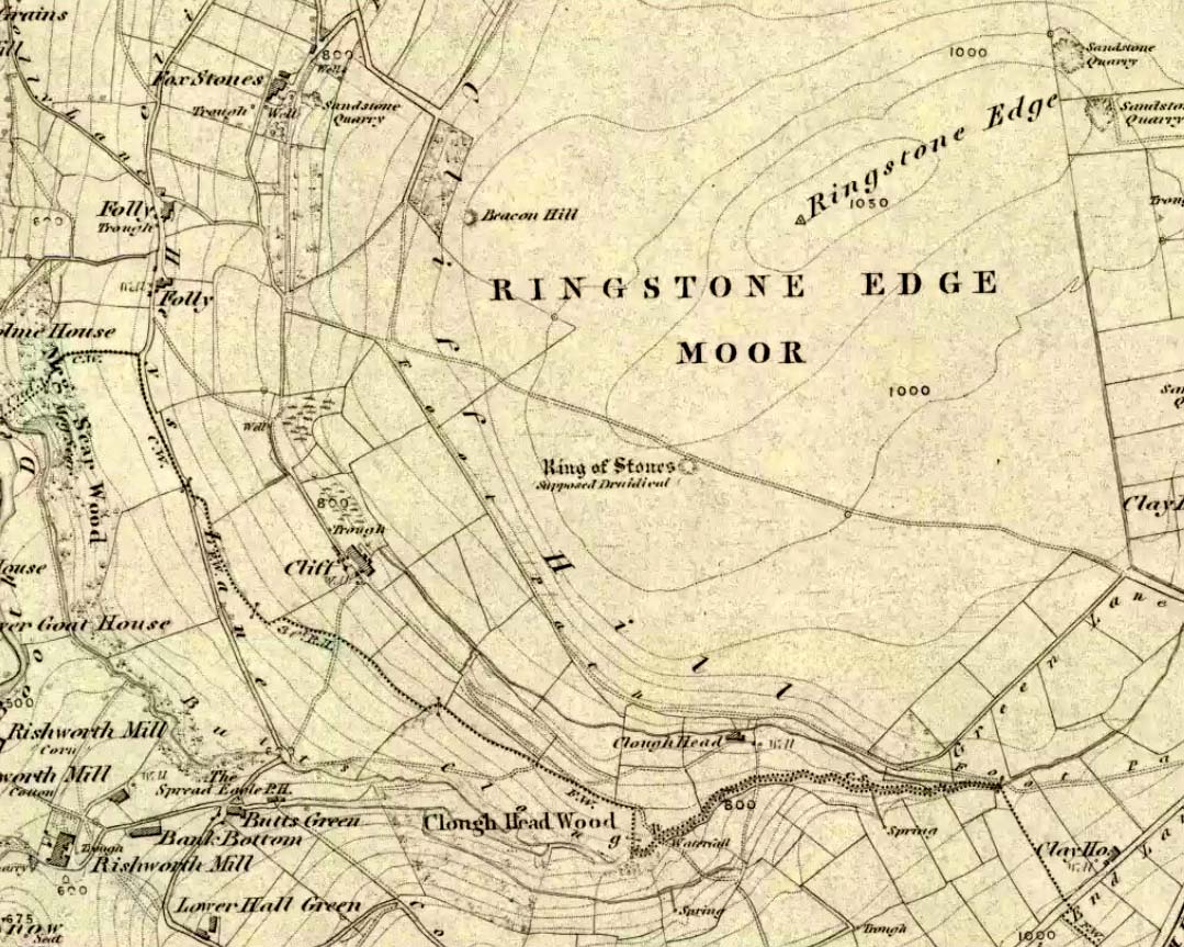
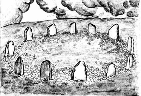
If we visit this site today, all we are left with is a scattered mass (or perhaps that should that be ‘mess’) of many hundreds of stones: the last remnants of what once would have been a proud circle of one form or another upon this small moorland plain. Its significance was such that the very moor on which its remains are scattered, was named after it: the Ringstone Edge Moor. But as with many sites from our megalithic period, this old place is but a shadow of its former self.
Gone are the upright monoliths which, tradition relates, once surrounded this low scattered circle of small loose stones (which would have made it look not unlike the wonderful stone circle of Temple Wood, Argyll). These standing stones were, so the folk record tells, removed near the end of the 18th century for use in some walling.
Described variously as a stone circle, ring cairn, cairn circle, an enclosure, and more, the site first seems to have been written about in 1775 by the great historian John Watson. When he was vicar of the local parish in Halifax (not far from here) this “ring of stones” as he called them, was “called the Wolf-fold.” Nearly one hundred years later, in F.A. Leyland’s superb commentary to Watson’s work, he wrote,
“The stones which constituted the circle at the time of their removal stood upwards of three feet…and the remain formed a striking object on the moor. The original number of stones of which the circle was formed is unknown, having long been in ruin and reduced in quantity before being finally removed. This was effected about twelve years since by the present tenant of the dam.” – that is, around 1859.
However, when Crabtree (1836) described the circle a decade or two earlier, he made no mention of such standing stones — although we must consider that Crabtree was very much like many modern academic archaeologists who tended to copy the works of others, much less than getting out in the field to see for himself.
At the beginning of the 20th century, the lore telling of the standing stones’ demise was repeated by local historian John Priestley (1903), when he said that: “all the large stones…were carted away about forty years ago” — that is, around 1863.
So it would seem that the very final destruction of the standing stones here, occurred sometime during the four year gap which Messrs. Leyland and Priestley describe.
More than fifty years later, Huddersfield historian James Petch (1924) came here to explore whatever remains he could find, and told:
“On top of a flat plateau on this moor, with an extensive view on all sides save on the north, where there is a gentle slope for some hundreds of yards up to the summit of the hill, there are distinct traces of a circular ring of small stones. Pygmie flints have been picked up within a yard or two, but the only other fact to be noted about this earthwork is that there is a tradition to the effect that much earth has been removed from this site. It is not altogether impossible that this is a scanty remnant of a round barrow.”
This latter remark of Mr Petch seems most probable. The excessive scatter of small stones typifies the remains of many of the Pennine giant cairns, from the Little Skirtful on Burley Moor and giant tombs of the Black Hills near Skipton, to the similar monuments of our Devil’s Apronful, Pendle, etc, etc.
Close to this cairn circle, wrote Sidney Jackson (1968), there used to be the remains of an Iron Age settlement, “marked by wall foundations (but) is now covered by the waters of Ringstone Reservoir.”
Folklore
There is very little folklore that I’ve found here. Watson (1775) throws the usual idea that the place was a site of druidical worship; but other than that we only have a local Ripponden writer’s account, which told that there was once the ghost of a white lady that was once said to walk along the path somewhere between here and the Beacon Hill tumulus, a short distance to the north.
Takes a bitta finding – especially if some dood’s knocked it down again (as happens up here). Best thing to do is get to the Miller’s Grave prehistoric cairn, which is only a few hundred yards away. From Miller’s Grave, walk due west for 200 yards till you hit once a ditched footpaths, where you should turn right. A short distance along you’ll hit a 5-foot-tall boundary stone called the Greenwood Stone with ‘1775’ carved on one side. From here, walk due south into the heather for 75 yards. You’re very close!
Archaeology & History
We resurrected this old standing stone in 1996, several years after first discovering it laid amidst the heather in the early 1990s. It appeared to mark an old boundary line (no longer used) betwixt Wadsworth Moor and Midgley Moor, but its nature is distinctly prehistoric. The remains of a small hut circle (seemingly Bronze Age, though excavation is needed) can be found a short distance to the west, though this is hard to find when the heather has grown. Other seemingly prehistoric remains scatter the ground nearby, none of which have received the attention of archaeologists.
Greenwood ‘B’ on a grey day
As you can see from these grey, rain-swept images, this upright stone is well-weathered (though we need to visit here again soon and get some better photos). It stands some 4-feet tall and may have accompanied one or two other monoliths close by. The suggestion by one Peter Evans that the Greenwood B stone stood “possibly at the centre of a stone circle” is sadly untrue (soz Peter); though it probably had some relationship with the Millers Grave cairn site, a few hundred yards equinox east.
References:
Bennett, Paul, The Old Stones of Elmet, Capall Bann: Milverton 2001.
Way off from seemingly anywhere this one – on the southern foothills of the great Cuillins, by the western edge of a seemingly unnamed loch. (most unusual) Take the Elgol road (A881) south from Broadford, nearly to its end, keeping an eye out for Kirkibost a few miles from the very end of the road. Just past here, stop and walk the track west to Camasunary a half-mile along, through the small forestry-bit, then follow the line of the trees north and keep going a bit more till y’ reach the nice stream that feeds that unnamed loch. Cross the stream!
Archaeology & History
Alexander Thom’s 1967 drawing
A fascinating little site this one! Perhaps consisting of as many as eight stones at one time, only three stand visible today. Alexander Thom (1967) reported finding other stones in this circle “being buried in the peat, but prodding revealed their position roughly” — as shown on his drawing here. There may at one time have been as many as eight stones here, but the site itself is quite small, making a ring of stones only 21-feet across (or 8 megalithic yards as Thom had it). The ruinous state of the site was put down to the stupidity of the Church of Scotland issuing “instructions that all stones in Skye were to be thrown down” a few centuries back.
Aubrey Burl’s later ‘four-poster’ summary
Aubrey Burl reported that “there were once at least 4 stones here, the tallest being of 6ft 6ins (2m) high,” and wondered whether this was one of the many ‘four-poster’ stone circles that scatter Scotland and elsewhere. An issue he seemed comfortable to proclaim a few years later in his survey of such sites. (Burl 1988) Of those stones still standing, the tallest is just 5 feet high; but there’s the impressive 11½-foot long monolith laying on the southeast edge of the ring! Mr Burl also pointed out that some
“casual digging inside the ring around 1860 uncovered a blackpolished stone about 1½ ins (4cm) long, ‘somewhat resembling a small pestle.'”
I found the proximity of the Cille Mhaire burial ground a mile west of here more than a bit intriguing (though didn’t have time to assess its geomantic relationship further). And the reported presence of prehistoric cairns nearby imply that the Na Clachan Bhreige ‘circle’ had some relationship with death and burial.
Folklore
The folkname of ‘The False Stones’ comes from that well-known tale of the site “supposedly being the remains of three men turned into stone for deserting their wives.” Something which Otta Swire (1964) thought was likely told by christian converts. It would have probably replaced an earlier tale of the stones being the site where some ancestral spirits lived. Swire also told that,
“these were once, if tradition is to be believed, Stones of Wisdom who could both foretell the future and show justice as between man and man.”
Burl (1988) also points out how,
“The name, Na Clachan Bhreige, has been variously pointed translated as ‘the judicial stones’, a place where medieval law courts were held, as in several other Scottish rings. It has also been interpreted as ‘the stone of lies, or falsehood.'”
References:
Burl, Aubrey, Four Posters: Bronze Age Stone Circles of Western Europe, BAR: Oxford 1988.
Grinsell, L.V., Folklore of Prehistoric Sites in Britain, Hale: Newton Abbot 1976.
Swire, Otta F., Skye: The Island and its Legends, Blackie & Sons: Glasgow 1961.
Thom, Alexander, Megalithic Sites in Britain, Oxford University Press 1967.
Thom, A., Thom, A.S. & Burl, Aubrey, Megalithic Rings, BAR: Oxford 1980.
Pretty easy really. Get to the ancient St. Michael’s Church on the dead-end road just outside of Linton village. As you approach it, look into the field on your right. Y’ can’t miss it!
Archaeology & History
Linton ‘Standing Stone’
This is an oddity. It could perhaps be little more than one of the Norber erratics found a few miles further north — but it looks more like a smaller version of one of the Avebury sarsens! Just under six-feet tall, it was shown to me by Adrian Lord yesterday (when the heavens subsequently opened and an outstanding downpour-and-half followed), who’d come across it only a week or two earlier themselves when they visited the ancient church next door. The stone certainly aint in any archaeology registers (no surprise there); and as one local man we spoke to yesterday told us, “there used to be several other standing stones in the same field, cos I remember ’em when I was a kid. ” The gent we spoke to seemed to know just about everything about the local archaeology and history of the area (one of those “damn good locals” you’re sometimes lucky to find!). He told us that the other stones which used to be there had been moved by the local farmer over the years, for use in his walls. So it seems that this is the last one standing. What looks like several other fallen stones can be seen further down the field, just next to the church. But this one’s pretty impressive.
Close-up of gnarled rockLooking south-ish!
The church of St. Michael next door was, tells the information inside, built upon some old pagan site — which gives added thought to this upright stone perhaps being the ruin of an old circle, or summat along those lines. The church, incidentally, is built right next to the River Wharfe.
Not far from here we find an almost inexhaustible supply of prehistoric remains at Grassington and district (less than a mile north). A huge excess of Bronze- and Iron Age remains scatter the fields all round the town. And aswell as the Yarnbury henge close by, there is — our local man told us, “another one which no-one knows abaat, not far away”!
Folklore
The folklore of this area is prodigious! There is faerie-lore, underworld tales, healing wells, black-dogs, ghosts, earthlights – tons of the damn stuff. But with such a mass of prehistoric remains, that aint too surprising. And although there appears no direct reference to this particular stone (cos I can’t find a damn reference about it), the old Yorkshire history magus, Harry Speight (1900), wrote of something a short distance away along the lane from the church. He told that,
“In the field-wall beside the road may be seen some huge glacial boulders, and there is one very large one standing alone in the adjoining field, which from one point of view bears a striking resemblance to a human visage; and a notion prevails among the young folk of the neighbourhood that this stone will fall on its face when it hears the cock crow.”
Just the sort of lore we find attached to some other standing stones in certain parts of the country. And in fact, from some angles, this ‘ere stone has the simulacrum of a face upon it; so this could be the one Speight mentions (though his directions would be, unusually, a little out).
There are heathen oddities about the church aswell: distinctly pre-christian ones. An old “posset-pot” was used for local families to drink from after the celebration of a birth, wedding or funeral here. And at Hallowtide – the old heathen New Year’s Day,
“certain herbs possessed the power of enabling those who were inclined to see their future husbands or wives, or even recognizing who was to die in the near future.”
And in an invocation of the great heathen god (the Church called it the devil), Speight also went on to tell that:
“The practice at Linton was to walk seven times round the church when the doomed one would appear.”
In a watered down version of this, local people found guilty of minor transgressions in and around Linton (thieves, fighters, piss-heads, etc),
“was compelled to seek expiation by walking three time around Linton Church.”
This would allegedly cure them of their ‘sins’! Rush-bearing ceremonies were also enacted here. On the hill above, the faerie-folk lived. And until recently, time itself was still being measured by the three stages of the day: sunrise, midday and sunset; avoiding the modern contrivances of the clock, and maintaining the old pre-christian tradition of time-keeping. Much more remains hidden…
References:
Speight, Harry, Upper Wharfedale, Elliott Stock: London 1900.
This stone stands on the south-side of the B4450 just north of the crossroads, halfway between Churchill and Chipping Norton. Generally troublesome to see at first as it tends to get hidden in the hedgerow, so you may need to furrow into the but shrubbery to get to it, but it’s not too difficult to locate with a bit of patience.
Archaeology & History
This small standing stone seems to have been described for the first time in O.G.S. Crawford’s (1925) fine survey of the regions prehistoric remains following a letter he received from a local man, Mr A.D. Passmore, who first drew it to the attention of archaeologists. Crawford told:
“This stone is a little over a mile southwest of Chipping Norton station. It stands in the hedge on the northwest side of the road and is about four feet high… Nothing more is known about it, but it seems not unlikely that it may be of considerable antiquity.”
A few years later Leslie Grinsell (1936) mentioned it in his equally fine survey of prehistoric English tombs and associated remains, describing here, “a large stone which may be the remains of a megalithic monument.” Tom Wilson then illustrated it in our crappy little Old Stones of Rollright (1999) work (which really needs updating and expanding). It’s a cute little stone and may have once served as a companion to a prehistoric tomb as there are many others nearby. It is also quite close to one of the local boundary lines and, p’raps, might once have served as a marker hereabouts. We might never know…
References:
Bennett, Paul & Wilson, Tom, The Old Stones of Rollright and District, Cockley: London 1999.
Crawford, O.G.S., The Long Barrows of the Cotswolds, John Bellows: Gloucester 1925.
Grinsell, Leslie V., The Ancient Burial Mounds of England, Methuen: London 1936.
Stone Circle (destroyed): OS Grid Reference – SO 303 976
Archaeology & History
Although geographically closer to the village of Priest Weston, this site — when still in existence — was in the parish of Churchstoke. To be found a half-mile west of White Grit (near the famous Mitchell’s Fold megalithic ring and standing very close to the local boundary line), the Welsh Royal Commision report (1911) told that its position was, “at the foot of the northern slope of Corndon Hill, and close to a stile on the south side of the road near the turning to Cliffdale Mine.” Found close to a number of other prehistoric remains, the Report told:
“It is certain that at this place there once stood a circle of eight or nine stones. An intelligent man, named John Jones, aged 74 years and a resident in the vicinity since his youth, remembers four stones arranged as though forming parts of a circle, with an appendage in a curve “like a hook.” About 100 yards distant was a cairn, the foundation of which is still discernible. The land was then unenclosed, but on its enclosure the cairn and the circle were rifled to provide stone for the construction of the existing fence. Mr Jones pointed out the four stones which had been members of the circle. The Rev. C. Hartshorne’s account of this circle in Salopia Antiqua, 1841, p.33, gives a slightly different account of the stones. He observes, “these three stones (the Whetstones) were formerly placed upright though they now lean, owing to the soft and boggy nature of the soil. The stand equidistant and assume a circcular position… The highest of these is four feet above the surface; 1 foot 6 inches in thickness; and 3 feet in width.”
When the Royal Commission lads got round to examining the remains here, they reported that,
“Only one stone is now to be found, embedded in the ground close to the stile entering the field, and this is so small that it is not likely to have formed one of the stones of the circle, or it must be a mere fragment of a larger mass.”
However, from the air, a very distinct circle is clearly visible, showing that something was here in bygone times. In all likelihood, there’s gonna be something just beneath the surface here to tell us more about whatever once stood here.
References:
Crawford, O.G.S., The Long Barrows of the Cotswolds, John Bellows: Gloucester 1925.
Royal Commission on Ancient & Historical Monuments, Wales, County of Montgomery, HMSO: London 1911.
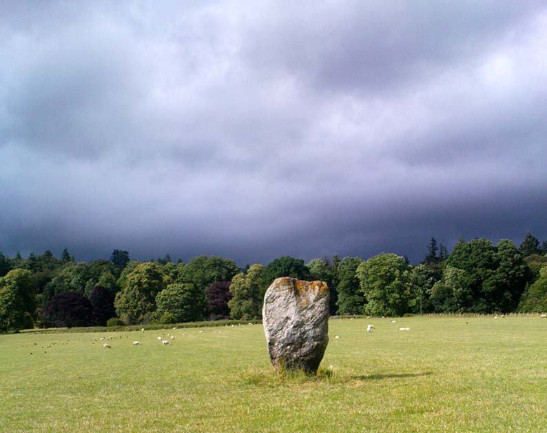
Going thru Pitlochry town, turn up the A924 road for about a mile till you hit the Moulin Inn on your left-hand side. Just past here, take the road left and continue for 2-300 yards until the stone in the field stands out on your right-hands side. Y’ can’t really miss it!
Archaeology & History
I should mebbe have this site entered as a ‘stone circle’ and not just an old monolith, as numerous other standing stones were in close attendant not too long ago and it was said to have been a circle. Certainly when the great Fred Coles (1908) talked about this place, he
“was informed by the tenant, Mr Reid…that many years ago, in his grandfather’s time, “there were several more stones standing”, all smaller than this monolith and that, upon the orders given by Mrs Grant Ferguson of Baledmund, some of these were saved from total demolition, and are supposed to be lying half-buried in the field to this day.”
…and here’s the big man close-up
Though I imagine these remnants have now been removed. Aerial images, when conditions are just right, might prove fruitful here.
But the solitary stone still standing here is quite a big fella. Heavily encrusted with quartz and more than 7 feet tall, it’s a nice fat chunky thing, with its lower half being somewhat slimmer than the top. Well worth having a look at!
Folklore
Once an old moot site, folklore also tells that an old market was once held here (there was some other folklore I had of this place, but can’t for the life of me find it at the moment!).


")