From the Port Appin ferry onto the northern tip of the island, go along the B8045 road for literally 3.5km (2.17 miles) and, shortly after passing Achuaran, a single small white house is on your right. Just yards before here is a small raised rocky knoll. …Or from the Achnacroish ferry, up the road for nearly a mile, then turn right along the B8045 road to Clachan. A half-mile past the hamlet, go past the old School House, then past Mountain View cottage, and the next small white house on the left has a rocky knoll just past it. Just over the wall from the road, a sign points out the legendary Chair that you’re seeking!
Archaeology & History
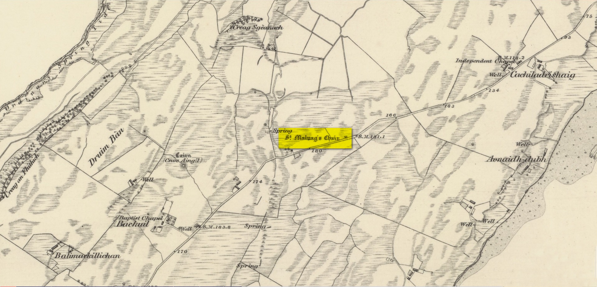
Site shown on 1875 map
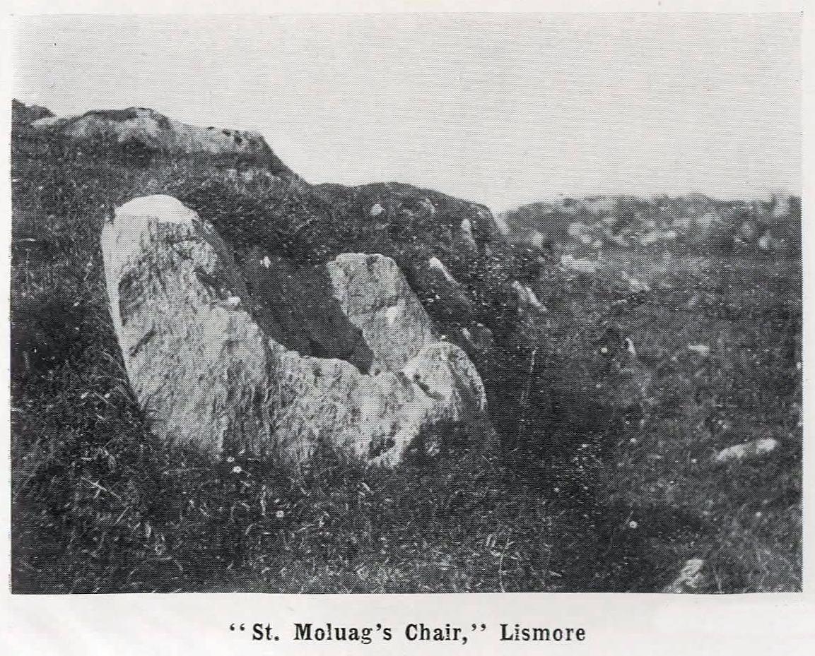
St Moluag, a contemporary of the renowned St Columba, was a 6th century Irish saint who came to reside on Lismore—“the sacred isle of the western Picts”—and here taught the early christian doctrines, fused with indigenous animistic traditions. He used sites of Nature as places of reflection and meditation and this chair-shaped boulder came to be a place renowned as one of his ritual sites, not far from his church. It was described in Frank Knight’s (1933) huge work as possessing healing properties:
“To sit in it used to be considered a sovereign remedy for rheumatism.”
The site was highlighted on the earliest Ordnance Survey map of the island and its lore was remembered by local people of the time. The chair had wider ‘arms’ until the beginning of the 20th century when in widening the road, they were accidentally broken off by one of the workmen.
References:
Knight, G.A. Frank, Archaeological Light on the Early Christianizing of Scotland – volume 1, James Clark: London 1933.
Acknowledgements:Huge thanks for use of the Ordnance Survey map in this site profile, reproduced with the kind permission of the National Library of Scotland.
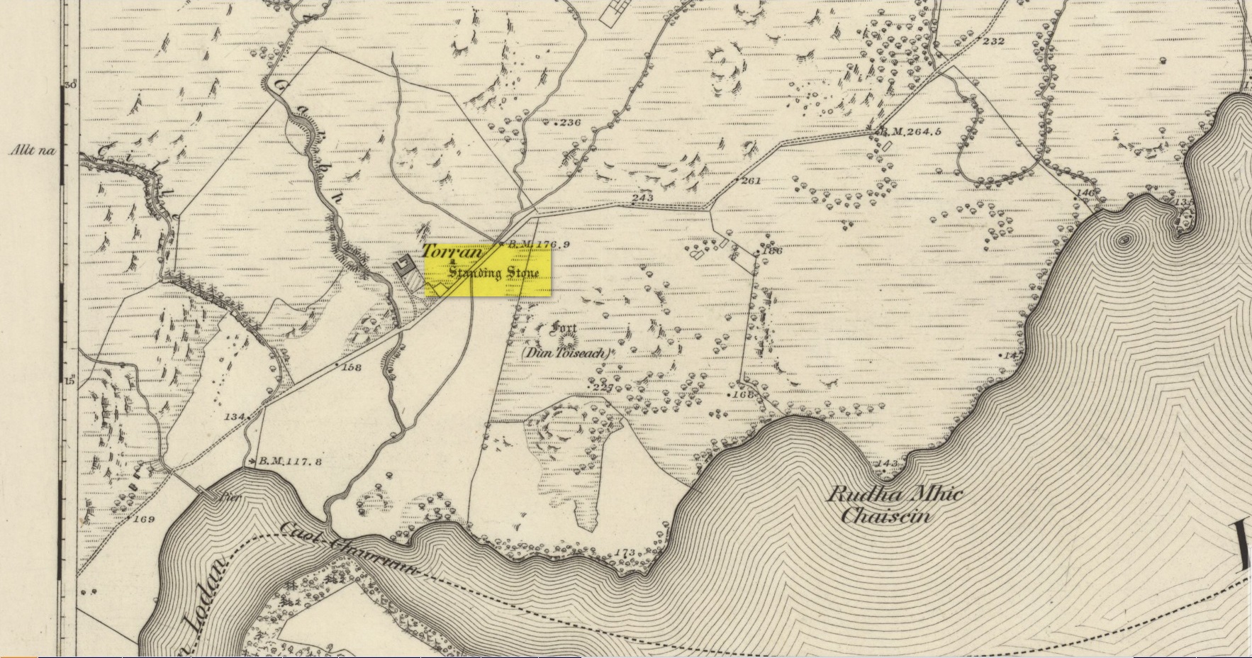
On the A816 road, a mile-and-a-bit north of Kilmartin, take the small road (east) to Ford—passing the Creagantairbh stone on your right, then a bit further on the Auchinellan stone on your left. Go through Ford village, making sure to stick to the road that goes along the north side of Loch Awe — as if you’re heading to Dalavich. Just fractionally over a mile out of Ford village, just where the road begins to swerve into a large bend, there’s a small left-turn that takes you to some houses. Just 60-70 yards along this little road, take the trivial little path on your right that takes you straight to a piece of manicured scrubland. If you walk into it, and bear left, you’ll see what you’re looking for. It’s unmissable!
Archaeology & History
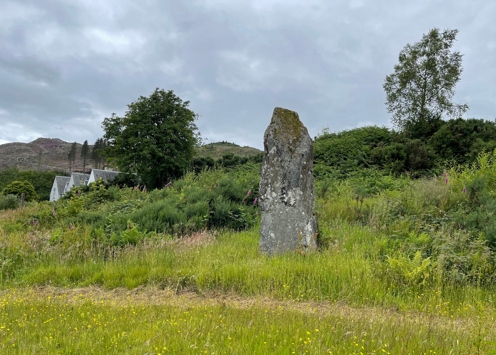
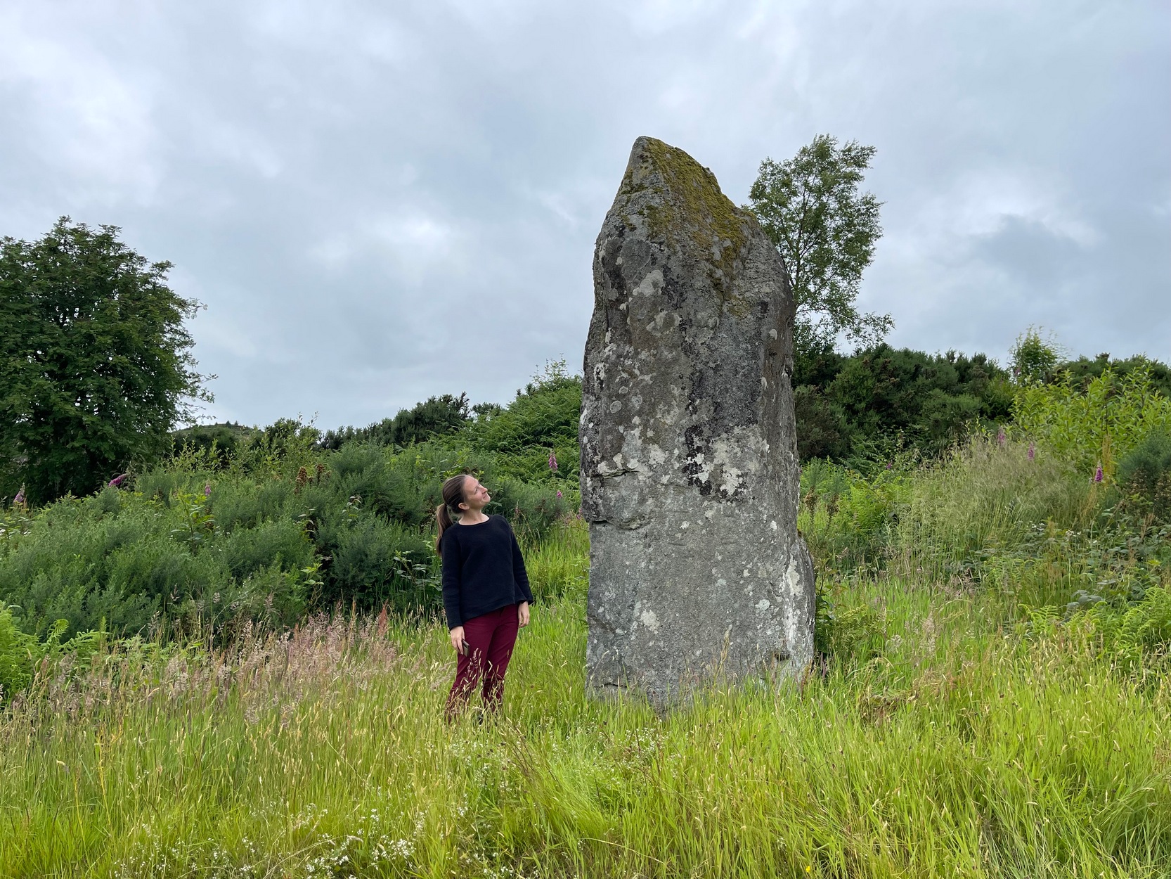
When I first visited here in the 1990s, a farm building stood by this huge standing stone and there were no other houses nearby. How things change—but thankfully our old sentinel stone is still living here.
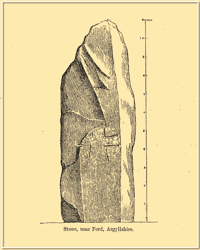
Site shown on 1875 mapRomilly Allen’s 1880 sketch
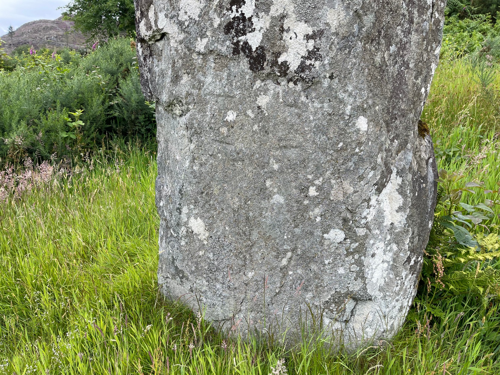
It was highlighted by the Ordnance Survey lads on their early map of the area, and visited a few years later by the great petroglyphic pioneer J. Romilly Allen. (1880) Standing eleven feet tall and more than four feet across at the base, Allen noticed that, about four feet above ground-level, someone had carved an old cross onto the northeast face of the stone (you can just make it out in the attached photos). It had obviously been carved many centuries ago, by a wandering christian no doubt—although it was incomplete and never finished. Perhaps the person who carved it was chased away by local folk, who would have obviously and rightly seen such an act as outright vandalism. The cross was deemed by Ian Fisher (2001) and the Royal Commission (1992) to be medieval in nature. Apparently there’s another, much fainter cross that was first mentioned by Marion Campbell etched on the other side of the stone, but in all the times I came here I was never able to make it out.
Old faint cross carvingSmall person, big stone!
But even further back in time someone had carved a cup-marking on the stone—and the cross was etched onto the same spot, enclosing the cup-mark. When I lived nearby, I made a sketch (long since lost) of what seemed to be two other faint cup-marks at one end of the extended arms of the cross, but on our recent visit here these were very hard to make out. When Ron Morris (1981) mentioned the stone in his survey, he mentioned its proximity to other cup-and-ring carvings immediately to the southeast and a hillock thereby, wondering whether there was “an astronomical complex” going on here. I doubt it—but I like the idea!
But it’s the size of the stone that’s most impressive here and keeps up with the tradition of similar megaliths in and around the Kilmartin area. Check the place out when you’re hunting the other stones nearby. You won’t be disappointed!
Folklore
Local tradition ascribed this great stone as marking the grave of an ancient warrior. The full folk tale seems to have been lost.
Fisher, Ian, Early Medieval Sculpture in the West Highlands and Islands, RCAHMS: Edinburgh 2001.
Morris, Ronald W.B., The Prehistoric Rock Art of Southern Scotland, BAR: Oxford 1981.
Royal Commission on the Ancient & Historical Monuments of Scotland, Argyll – Volume 6: Mid-Argyll and Cowal, HMSO: Edinburgh 1988.
Royal Commission on the Ancient & Historical Monuments of Scotland, Argyll – Volume 7: Mid-Argyll and Cowal: Medieval and Later Monuments, HMSO: Edinburgh 1992.
Ruggles, Clive, Megalithic Astronomy, BAR: Oxford 1984.
Swarbrick, Olaf, A Gazetteer of Prehistoric Standing Stones in Great Britain, BAR: Oxford 2012.
Acknowledgements:Huge thanks for use of the Ordnance Survey map in this site profile, reproduced with the kind permission of the National Library of Scotland.
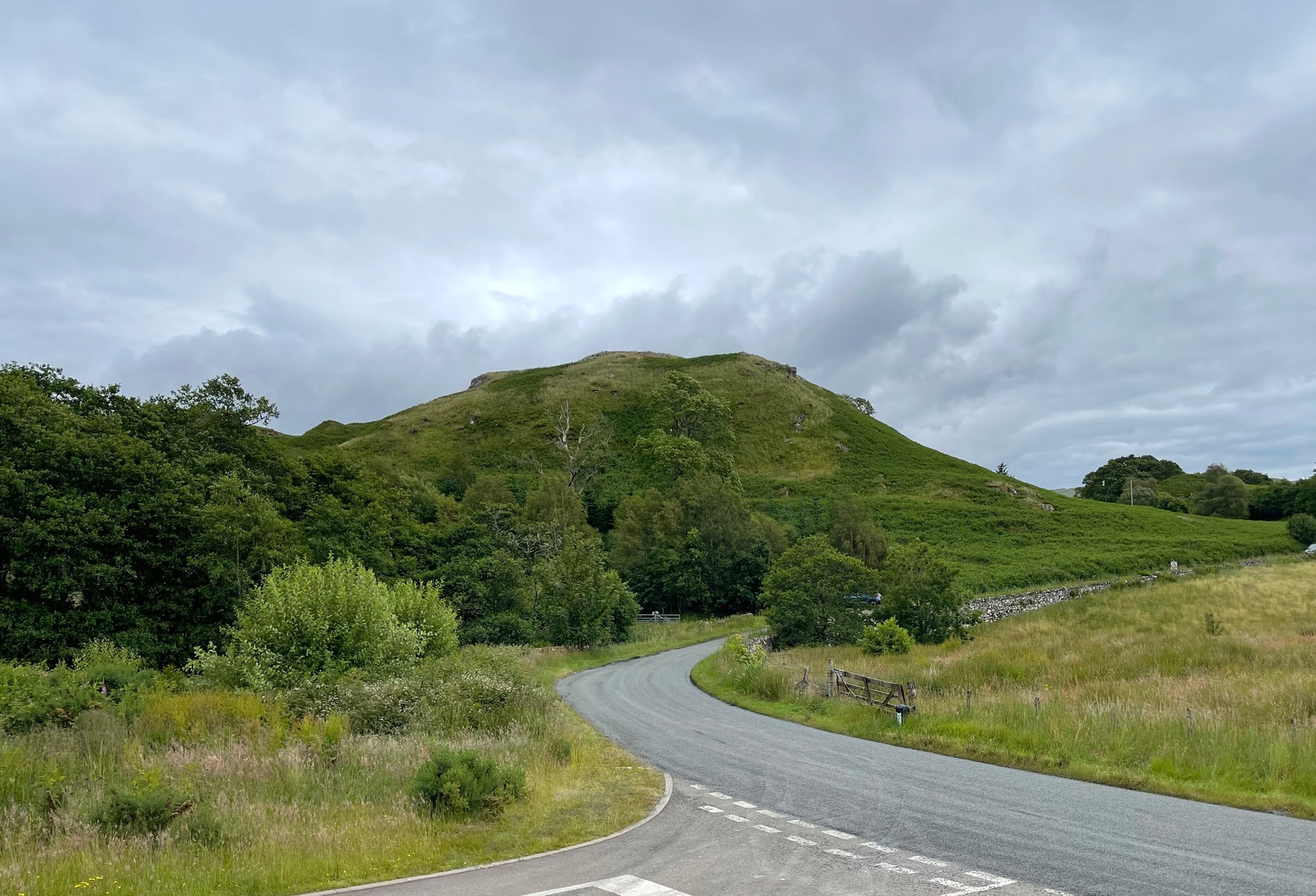
You can see the rocky hillock ‘pon which this old dun sits from the roadside – and can approach it by either climbing up the slope, or go round t’ back and approach it from t’ track. Either way, it’s easy to get to.
Archaeology & History
This old dun was rather ramshackled when I used to sit here, sometimes on my way home from working at the Inverliever Nursery, a bit further up the lochside — but it was a good spot to sit and daydream into Loch Awe and beyond…
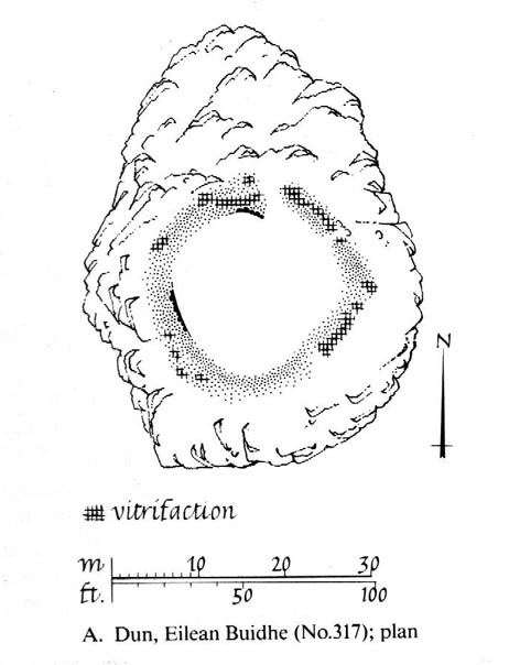
Described as a vitrified fort, the structure is oval in shape. Thought to have been constructed in the Iron Age, Dun Toiseach was originally about 50 feet across and its walls averaged 10 feet thick, with an entrance at its northeastern side. The Royal Commission lads (1988) described it thus:
Dun Toiseach plan (after RCAHMS 1988)
“Situated on a prominent rocky knoll overlooking the S end of Loch Awe 250m ESE of Torran farmsteading, there is a severely ruined dun measuring about 16m by 13m within a wall which has been some 4m thick. Two stretches of outer facing-stones are visible, as well as a few possible stones of the inner face, but, particularly on the NE, the wall has been severely robbed and the core material scattered. The entrance lies on the NE, the innermost portion of the SE passage-wall and what may be a door-jamb on the opposite side still being visible. The knoll has acted as a focus for recent field-walls, but there is no indication that it was additionally defended by outworks. A small modern cairn…surmounts the dun wall on the SE.”
References:
Royal Commission on the Ancient & Historical Monuments of Scotland, Argyll – Volume 6: Mid-Argyll and Cowal, HMSO: Edinburgh 1988.
Not to be confused with the Achnacreebeag chambered tomb a short distance to the east, Achnacree is a site that has been made ruinous over the last 100 years, prior to which — as R.A. Smith’s (1885) illustration here shows — we had a quite grand prehistoric chambered cairn to behold. It’s still worth looking at though!
R.A. Smith’s old drawingSmith’s early plan of the cairn
The once giant tomb is neolithic in age and nature, and was defined by Audrey Henshall (1972) as a passage grave of the Clyde Cairns group. It appears to have been built over two different periods: the earliest being when the first two internal chambers were done, “which in building technique and plan are comparable to a two-compartment Clyde-chamber and which may have been covered by a small cairn.” (RCAHMS 1974) Much later, the long passage seems to have been added and built over the original chambers.
Although Smith (1885) and Henshall describe the large cairn, the Scottish Royal Commission (1974) entry gives the most succint archaeocentric summary of the site:
“The cairn is about 24.4m in diameter and now stands to a height of some 3.4m on the S and 4.1m on the NE, although it is said to have been about 4.6m high before excavation; it consists of small and medium-sized stones, interspersed with a few large boulders. A low platform of cairn material, now grass-covered and about 1m high, extends round the base of the cairn and increases the overall diameter to about 40m. The entrance to the passage is on the SE side of the cairn and is marked by four upright stones, one of which is now leaning out of position. The central pair, set about 1.2m apart and protruding 1.3m and 0.4m above the cairn material, are the portal stones on either side of the passage, while the flanking pair may be the remains of a shallow forecourt. The passage, which measured 6.4m in length and 0.6m in width, was constructed of upright slate slabs about 1m in height, and the roof was composed of similar slabs. The excavator recorded that the passage was filled with stones, and these seem to indicate a deliberate blocking after the final burial-deposit. The chamber comprised three compartments. The outer, measuring 1.8m by 1.2m and about 2.1m in height, was constructed of upright slabs and drystone walling supplemented by corbelling, and was covered by a single capstone. The central compartment, measuring 2m by 0.7m and 1.6m in height, was entered across a large transverse slab, and the entrance itself appeared to have been deliberately sealed with stones ‘built firmly in after the chamber had been completed.’ The sides of this chamber were formed of blocks of stone supplemented by dry-stone walling, and it was roofed by a singular capstone. The inner compartment was entered across a sill-stone, and measured 1.4m by 0.9m and 1.7m in height. A combination of slabs and dry-stone walling had been employed in its construction, and it was roofed by a single massive capstone some 0.4m thick. Each side-wall was constructed of two slabs set lengthwise one above the other, in such a way that a narrow ledge was formed at their junction. On these two ledges a number of white quartz pebbles had been deliberately deposited… Three neolithic pottery bowls were discovered in the course of the excavation — a fragmentary vessel from the outer compartment, and one complete and one fragmentary bowl from the inner compartment.”
These bowls were sent to Edinburgh’s National Museum of Antiquities soon after being found.
Folklore
Those of you into earthlights will like this one! Also known as Carn Ban, or the White Cairn, aswell as Ossian’s Cairn, R. Angus Smith (1885:217) told how,
“it was curious…to listen to the superstitions that came out (about this tomb). One woman who lived here, and might therefore be considered an authority, said that she used to see lights upon it in dark nights.”
Another old local was truly terrified of the place, and said he would not enter this tomb for all the money in Lochnell Estate.
Regarding the various names given to the site, when Mr Smith (1885) wrote about it all those years ago, he told:
“We have often inquired the name of the cairn. The cairn really has had no definite name. Some people have called it Carn Ban or White Cairn, but that is evidently confusing it with the other cairn which we saw over the moss, and which is really whiter. Some people have called it Ossian’s Cairn, but that is not an old name, and even if it had been, we know that it is a common thing to attach this name to anything old. We call it Achnacree Cairn, from the name of the farm on which it stands.”
References:
Henshall, A.S., The Chambered Tombs of Scotland – volume 2, Edinburgh University Press 1972.
Royal Commission on the Ancient & Historical Monuments of Scotland, Argyll – Volume 2: Lorn, HMSO: Edinburgh 1974.
Go up from Oban on the A85, past Connel and towards Taynuilt, keeping your eye out for where the train-line crosses the road. Just before this is a small road on your left leading down to the sea, with the train line running parallel all the way down. Go right to the end and then look up to the rocky rise a coupla hundred yards on where the train line runs out of view round the coastal edge. That’s it!
Archaeology & History
When Scottish writer and historian R. Angus Smith (1885) first saw this, the close arrangement and size of the stones that make up the edges of this dun made him think this was actually a stone circle up here. Sadly it wasn’t to be. Following an examination of the site in 1969 by members of the Scottish Royal Commission (Argyll – Volume 2, 1975), they described Dun Chathach as,
“circular in plan…measuring 18.3 metres in diameter externally. The wall, which has been about 3.4 metres in average thickness, is now reduced to a low grass-grown stony bank, but considerable stretches of the outer face are still visible in situ. Many of the facing stones, which lie as much as 1.6 metres below the level of the summit, are of massive proportions, the largest measuring 1.4 metres by 1.3 metres and 1 metre high. It is uncertain which of the three gaps now visible in the wall indicates the site of the original entrance.”
Folklore
Legend has it that this was a hill of battles. It was also said by R. Angus Smith (1885) to “have been used as one of a chain of beacons,” with the next fire on being lit upon a small hill nearer Connel called Tom na h-aire, ‘the mound of watching.’
References:
Royal Commission on the Ancient & Historical Monuments, Scotland, Argyll- volume 2, HMSO: 1974.
Smith, R. Angus, Loch Etive and the Sons of Uisnach, Alexander Gardner: London & Paisley 1885.
Marked on the earliest 6-inch Ordnance Survey map of this area (1875), this 4ft tall standing stone (now gone) once stood on the east bank of the River Euchar. The prehistoric cairn 400 yards to the west on the other side of the river would seem to have had some relationship with the stone, as they aligned to the equinoxes.
References:
Royal Commission on the Ancient & Historical Monuments of Scotland, Argyll – volume 2: Lorn, HMSO: Edinburgh 1974.
As you enter the top eastern end of Glencoe, take the only tiny road to your left (south) into Glen Etive, past the great Buachaille Etive Mor (she kills four or five folk a year, so a local told me, as if to remind me who’s boss!), past Dalness for another couple of miles until you hit Invercarnan (watch you don’t miss it). Behind you are the great falls screaming down the mountain slopes on Buachaille’s south-side; but on the east-side of the road another 500 yards down (you’ll have to gerrout and walk down near the riverside – if you hit the tidgy bridge, you’ve missed it) on the far side of the trees behind the singular house, the little mound can be seen.
Archaeology & History
Down this awesome valley (perhaps mi favourite – it’s difficult to say) is very very little in terms of ancient remains – at least according to the record books. I find this hard to believe. Etive is scattered with various ancient legends of hero-figures and mythical creatures, and harbours geological features, waterfalls and magic unlike anywhere else in these great mountains. The tomb here is only a small one, but it’s pretty well-preserved. It’s about 30 feet across and three or four feet high. Described by the Royal Commission lads, thus:
“One of the best-preserved cairns in Lorn is situated in pasture on the west bank of the River Etive, some 700m south of Invercharnan. Bowl-shaped in profile, it measures 8.25m in diameter by 1.6m in height, and has been constructed with a kerb of boulders on which a second retaining course of stones has been carefully set.”
…Tis an utterly gorgeous arena. The cairn is good – but it’s the land upon which it rests that truly holds you. I was just ambling here – and the rain didn’t stop for three solid days, but I could have stayed amidst its blessing for an eternity. On the walk back up to my tent, two mature stags came out from the trees and enacted a play-fight right in front of me, careless of me being there. It was utterly superb to watch! I was saturated, cold, hungry – but watching this stopped it all. I bimbled back to mi tent in that dreamy state beloved of such places when the elements are alive.
Anyway – back to normality! Just north of the old tomb – which I didn’t know at the time as I had no decent map – is found the ‘Crag of the Cailleach’ (a favourite creature of mine); and there are also a couple of old fairy place-names a few hundred yards to the southeast. There’s got to be more ancient stuff around here tat are off the record-books. Bimbling expeditions are a-calling…!
References:
Barnett, T. Ratcliffe, The Land of Lorne and the Isles of Rest, W. & R. Chambers: Edinburgh 1933.
Royal Commission on the Ancient & Historical Monuments of Scotland, Argyll – volume 2: Lorn, HMSO: Edinburgh 1974.
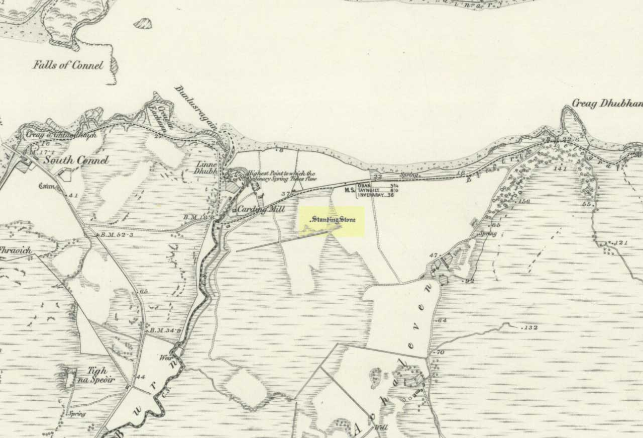
The Royal Commission for Historic Scotland (1974) recorded this “stone that formerly stood within the area now occupied by Connel Station,” which was thought to have been destroyed shortly before construction of the said building. Thankfully the Ordnance Survey lads recorded its position on their cartographic ventures here in 1871. Mr R.A. Smith (1874) also mentioned the site, albeit briefly, in his fine series of essays on the antiquities of Loch Etive, telling us:
“Above Connell Ferry we come to a small brook called Lusragan, and a few houses with a mill called Clachaleven. To the east, in a field above the road, is a large standing stone, and around it marks where others, well remembered, lately stood.”
But sadly it seems, these have all gone.
References:
Royal Commission for Ancient & Historical Monuments, Scotland, Argyll – volume 2: Lorn, HMSO: Edinburgh 1974.
Although the lads at the Scottish Royal Commission (1974) initially described this site as a ‘Standing Stone’, it is in fact,
“an erratic boulder of granite roughly shaped in the form of a cross… It measures 0.8m in height, 0.6m in width at base, and 0.4m in width at the top…(and) the stone is supposed to have marked a boundary.”
The site was evidently of some mythic importance, as the great Cathedral of St. Moluag was built next to the stone — unless the giant cairn of Cnoc Aingil, 500 yards away, was to blame. A holy well of this saint’s name (an obvious heathen site beforehand) is also nearby.
Folklore
Although this stone was dedicated to swans, I’ve not found the story behind the name. There were no buried swans here, but local tradition told that this old boulder could give sanctuary to anyone who touched it, or ran round it sunwise. The Hebridean folklorist Otta Swire (1964) told that,
“anyone who claimed such sanctuary had his case considered by ‘the Elders.’ If they considered his plea justified, they ‘came out and walked sun-wise round the Swan Stone.’ If they did not approve of his right to sanctuary, they walked round it anti-clockwise and the man was then given over, not to his enemies, but ‘to Authority’ to be tried.”
This old tradition derives from well known pre-christian rites. Swire also reported that even in the 1960s here, “at funerals the coffin is always carried round the grave sun-wise before being laid in it.” An old cross placed in the Field of the Cross next to the stone was an attempt to tease folk away from heathen rites of the stone, but failed.
References:
Royal Commission on the Ancient & Historical Monuments of Scotland, Argyll – volume 2: Lorn, RCAHMS: Edinburgh 1974.
Swire, O.F., The Inner Hebrides and their Legends, Collins: London 1964.
Sadly this site can no longer be seen, but it was evidently something worth seeing in its day. Twas found “on the north side of Loch Laich, opposite Castle Stalker.”
Archaeology & History
In 1758 W. Burrell wrote about “a very large circular heap of stones, called Cairnbane, in which are said to be several subterraneous apartments, the passages leading to them, supported by large beams of timber in some places, in others by large stones, the entrance is now closed with a stone.” But in 1760 Richard Pococke reported that he could enter the cairn, saying that,
“on the west side of it a little way up is a very difficult entrance which leads to a cell about two yards long and one and a half broad, a this by a sort of door place to another about the same dimensions. I observed in some parts the stones on the side are laid flat, in others edge way, and a little sloping, and large stones are laid across on the top; To the north of it is a low heap of stones, in which three mouths of entrances are very visible, and there seemed to be two more; …the large one is twelve yards long at the top and about a yard broad: It is not improbable that these cells were built all round and several stories of them one over another.”
Explorations here by A.S. Henshall and the Royal Commission for Historic Scotland were unable to find the site and it has been deemed missing or destroyed. I have yet to seek out any folklore relating to this lost site, but would be very surprised if there wasn’t something loitering in some of the old tongues and tomes!
References:
Royal Commission on the Ancient & Historical Monuments of Scotland, Argyll – volume 2: Lorn, HMSO: Edinburgh 1975.
")
 - plan")