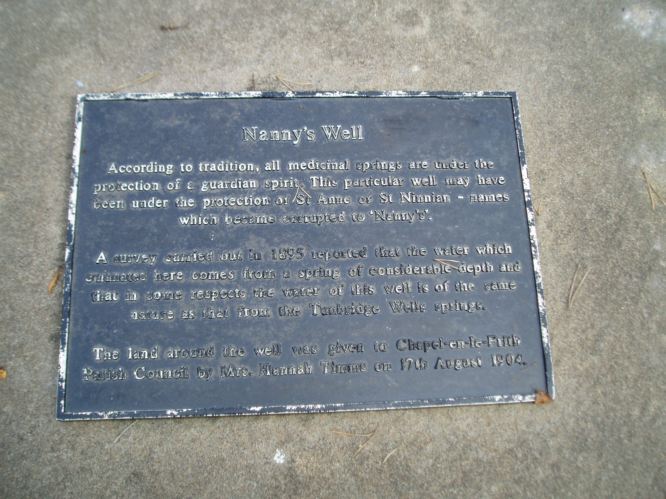
To find Nanny’s Well, take B5474 out of Chapel and take the right hand turning called Crossings road (which goes to Chinley) which is before Frith view on the left. Continue until the small wall surrounding the site can be seen on the right.
Archaeology & History
The name it is said to be either from St Ninian (less likely) or St Anne (more likely as she is also considered the mother of Mary and thus Grandmother of Jesus).
The Nanny well pump
It is described in M.J.B Baddeley’s Peak district of Derbyshire (1913) and the neighbourhood as:
“a valuable but neglected spring of chalybeate water.”
Yet in 1895, a Manchester firm of Grace, Calvert and Thompson analysed it and found it:
“not polluted to any extent with organic matter of animal or vegetable origin and comes from a spring of considerable depth and that no surface water has become mixed with it’…in same respects the water of this well is of the same nature as that from the Tunbridge Wells springs.”
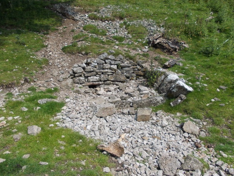
The site is now an iron pump by the side of Crossings Road, known as Nanny Well Road, enclosed in a low wall along which. The pump no longer works and the well capped but it can be heard and just about seen through a crack beneath.
A peer through the crack shows running water!
Folklore
Nanny well plaque
It was visited on Easter Morning, with sugar or licorice to make Spanish Water, and then the bottles were hung around their necks. The site is one of four wells dressed annually since the 1980s in July and the site is blessed.
Extracted from Parish, R. B., (2008) Holy Wells and Healing springs of Derbyshire
The genuine St. Bertram’s well is not easy to find and I recommend using the OS map carefully. It is reached by taking the footpath that leads off at the left passing the cross out of the village. Follow this until the end of the dry stone walling on the right and then divert from the footpath to the right where the well can be seen. The second well is easily found in the field between the church and the Hall.
Archaeology and History
Bertram is an interesting local saint, dating from around the 7th-8th century. Briefly, he is said to be of Royal Irish lineage but after making a princess pregnant, escaped to England where he sheltered in the woods around Ilam. The story is told by Alexander, a monk, in the 13th century who notes:
“They were in hiding in a dense forest when lo ! the time of her childbirth came upon them suddenly ; born of pain and river of sorrow! A pitiful child bed indeed! While Bertellinus went out to get the necessary help of a midwife the woman and her child breathed their last amid the fangs of wolves. Bertellinus on his return imagined that this calamity had befallen because of his own sin, and spent three days in mourning rites”.
As a result he became a hermit living in a cave in the valley near Ilam. Despite the earliest mention being Plot, the local geography is suggestive that this is the site of an early Christian hermitage site, although no mention of a well is noted in his legends it can be noted. Currently, the well is surrounded on four sides by varying low stone walling, about two feet or so at its highest (although it appears to have been built up and down over the time I have visited the well). The spring flows from a small, less than a foot square chamber, enclosed in stone and set into the bank through a channel in the rubble flow and out along the path towards it.
Since the 1990s, on the first Saturday in August, the Orthodox Church makes a pilgrimage to the site and blesses the well. Interestingly, literature available from the National Trust shop fails to mention this well, but notes a more substantial second St Bertram’s Well close by the church and surrounded by a rectangular stone wall with steps down, the water arises here at greater speed and flows into the nearby River Manifold. Visually it is more impressive and more accessible but whether there is any long tradition of this second well is unclear, but authors such as the Thompsons’s (2004) The Water of Life: Springs and Wells of Mainland Britain and Bord (2008) Holy Wells of Britain appear to have fostered its reputation.
Incidentally, the church boasts the remains of St Bertram’s shrine with foramina and the church yard has two Saxon crosses, making a visit to the village a must for those interested in early medieval history.
Folklore
“St Bertram’s Ash… grows over a spring which bears the name of the same Saint… The common people superstitiously believe, that tis very dangerous to break a bough from it: so great a care has St Bertram of his Ash to this very day. And yet they have not so much as a Legend amongst them, either of this Saint’s miracles, or what he was; onely that he was Founder of their Church”
Such notes Plot (1686) The Natural History of Stafford-Shire, the earliest reference of this fascinating site. By Browne (1888) in his An Account of the Three Ancient Cross Shafts, the Font, and St Bertram’s Shrine, at Ilam, noted that the ash had gone, but the water was still being used. He states that:
“The late Mrs Watts Russell always had her drinking water from it.”
Extracted and amended from the forthcoming Holy wells and healing springs of Staffordshire by R. B. Parish (2008)
From the old cross in the middle of the village, walk along the A820 Balkerach Street main road (NOT down George Street) until you reach Station Wynd on your right. Walk up here for 100 yards towards the new housing estate (don’t buy these places – they’re dreadful quality beneath the veneers) and there, on a small grassy rise on the left just before the car park, stands our stone!
Archaeology & History
This little-known monolith on the northern edge of little Doune village, was recently moved a short distance from its original position thanks to another one of those sad Barratt housing estates being built here; but at least it has received protection with the surrounding fence and notice board telling its brief history and folklore (better than being destroyed I s’ppose).
Stone on 1866 OS map
Standing less than five feet tall, local lore tells that it has been moved around close to this spot several times in the last couple of centuries. Although not mentioned in Hutchinson’s (1893) essay on local megaliths, the stone was highlighted on the 1866 Ordnance Survey of Doune, where the non-antiquated lettering showed how it was thought to be Roman in origin, not prehistoric.
Folklore
Trysting Stane, looking NE
The name of the stone comes from it being used as a place where deeds were sworn, with the stone as witness to the words proclaimed by both parties (implying a living presence, or animistic formula of great age). This activity was continued in the local ‘trysts’ or cattle fairs held a mile away, where buyers swore the sale of cattle at this stone—again with the stone being ‘witness’ to the spoken deals. It was also used as a counter where gold was exchanged for cattle bought and sold during the Michaelmas and Martinmas Fairs. Sue Harvey (2006) told that this standing stone,
“was called the Devil’s Head and was used during past Doune fairs to count gold on when cattle were being bought and sold.”
In local newspaper accounts from the 1950s, local historian Moray S. Mackay (1984) told how the children of the village used to gather round the stone, holding hands, and sing,
Olie Olie, peep, peep, peep,
Here’s the man with the cloven feet,
Here’s his head, but where’s his feet?
Olie Olie, peep, peep, peep.
Notice board telling its tale…Looking at the stone on its rise
This implies the stone once possessed a myth relating to a petrified ancestral deity of animistic (pre-christian) origin, but as yet we have found no additional information allowing us a confirmation of this probability. A correlate of this theme—i.e., of the stone being the head of a deity—is found in West Yorkshire (amongst many other places), where one of the little known Cuckoo Stones was once known to be a local giant until a hero-figure appeared and cut off his head, leaving only his body which was then turned to stone. Mircea Eliade (1958; 1963) cites examples of animistic religious rites and events explaining this early petrification formula via creation myths, etc. (we find very clear evidences of animistic worldviews and practices still prevailing in the mountains just a few miles north and west, still enacted by local people)
Folklore also alleged that the stone was Roman in nature, but neither archaeology nor the architectural form of the stone implies this. Roman stones were cut and dressed—unlike the traditional looking Bronze Age, rough, uncut fella standing here.
References:
Eliade, Mircea, Patterns in Comparative Religion, Sheed & Ward: London 1958.
Eliade, Mircea, Myth and Reality, Harper & Row: San Francisco 1963.
Harvey, Sue, Doune and Deanston, Kilmadock Development Centre 2006.
Hutchinson, A.F., “The Standing Stones of Stirling District,” in The Stirling Antiquary, volume 1, 1893.
The stone circle of Fingal’s Cauldron Seat, Machrie Moor, Arran (photo by Aisha Domleo)
By whichever way you come (be it from Brodick on the east, Lochranza to the north) ask any local the way to Machrie and they’ll point you the road onto the west side of the island, roughly halfway. You’re after the hamlets of Blackwaterfoot or Auchagallon. From either of these spots, take the road to Tormore. From here, the dirt-track east close to the Machrie Water is where you need to walk. About a mile along this well-defined track you’ll see the large barn ahead of you. Hereabouts you’ll begin to notice some very tall standing stones. Keep walking on the track, and the first double-ring of smaller stones to your right is the place yer after!
Archaeology & History
Approaching the ring (photo by Aisha Domleo)
This is one well-preserved stone circle in a superb setting with other large megalithic rings all close by—at least 12 of them!—set upon the flat open moorlands on the west side of Arran, with views in all directions sending the enquiring nose tasting for more wherever the eyes gaze…. It has been written about by many many writers over the last few centuries—which aint surprising! But it was in recent times that the place was said by Aubrey Burl (1981) to be “holy ground,” because although there are many prehistoric settlement sites and other remains scattered across this landscape,
“it is noticeable that the dozens of huts whose ruins litter the moor were built well away to the west, none of them near these powerful and lonely stones.”
1832 sketch of Fingal’s Cauldron by James Skene
It’s a fair point.
Fingal’s Cauldron was first defined in an archaeological context by James Bryce in 1863, who named it the ‘Machrie Moor 5’ stone circle (MM5)—and it was he and several others who dug into the ring, to see what it might be hiding!
“Excavating at the centre we found a small cist at less than a foot in depth, and lying about north-east. It was covered by a small lid, and the dimensions were 2 feet 2 inches in length, 10½ inches in depth, and 11 inches in width. Inside there were several bone fragments and black earth. A flint implement was found in the stony soil above, and three other flint fragments, but nothing of this kind in the cist itself. This was of much ruder structure than any we had seen before (Ed. – i.e., in the other Machrie circles); it was cut out of the sold sandstone rock, but with little care or exactness; the sides however, were nearly perpendicular. The difficulty of excavating without iron tools may account for the smaller size and ruder form of this cist. No other cist was found, nor remains of any kind, though a trial was made at several points around the centre. A deep opening was also made on both sides of the upright stone, but nothing was met with worthy of being recorded.”
A.E. Roy’s 1967 site-plan
Described thereafter a number of times by different historians and antiquarians, Fingal’s Cauldron (and its associates) was then recounted in the Machrie Moor survey of Mr Balfour (1910) in his magnum opus on the Isle of Arran. Although he gave more attention to the other stone circles in this multiple megalithic complex, he did thankfully make note that,
“upon higher ground free of peat, and immediately to the south of the farmhouse, is the celebrated double circle of granite blocks known popularly as Fingal’s Cauldron Seat. The inner ring consists of eight and the outer of fourteen blocks. The diameter of the inner circle is 36 feet and of the outer 57 feet. The largest stones are in the inner series; they are more or less round-topped blocks, about 4 feet high. One of the stones of the outer ring has a ledge which is perforated by a round hole, with the edges worn smooth.
“In the centre of the inner ring, only a foot from the surface, a ruined cist was laid bare. It had been previously disturbed, and was represented by two stones only, lying parallel to one another. There was no capstone, and no relics were discovered.”
More recently in the 1960s, another survey of Fingal’s Cauldron was undertaken by A.E. Roy and other archaeologists. They found nothing new of any value, but gave us the ground-plan we see here (sadly it seems that Alexander Thom didn’t bless this site with his theodolite and survey). Aubrey Burl re-examined the site again during his own survey in the 1980s.
An elemental called Lara sat seated on one of the uprights! (photo by Aisha Domleo)Small section of inner & outer rings (photo by Aisha Domleo)
There are other curious features to this ring that aint generally talked about amongst the archaeo-fraternity, out of fear of sounding inspiring perhaps… In the 1980s, a chap called Paul Devereux and a number of physicists organized volunteers from across the country to monitor electromagnetic anomalies at many megalithic rings, in order to explore the validity, or otherwise, of the idea that there were ‘energies’ at stone circles. The study was called The Dragon Project and went on for many years. The Machrie Moor complex was one of the places where examinations of electromagnetic fields were undertaken—Fingal’s Cauldron being one of them. Devereux (1990) tells us a small part of the story:
“In May 1983 Dave and Lynn Patrick monitored several of the Machrie Moor circles, including MM5, with a geiger counter for the Gaia Programme. They also took background control readings and monitored a non-megalithic ‘dummy site’ for comparisons.
“Five of the circles…gave average site readings 2 to 13 per cent higher than background, but MM5 gave a site average of 33 per cent above background. A non-megalithic ‘dummy site’ was 5 per cent above background. The Patricks had taken 20 readings within MM5—one hour of monitoring time—plotted onto the ground-plan. There was no mystery about why the site gave a higher average than anywhere else, and a third higher than background—the stones are radioactive granite, and there are 23 of them. But one stone, the tallest, and the most westerly of the upright stones in the inner ring, is particularly energetic, giving readings 16 per cent above the next most radioactive stone in the double ring, and more than that for the other 58 stones monitored in the Patrick’s study on Machrie Moor.
“I took measurements at the site myself in April 1988, using new equipment, and confirmed that the MM5 stone did indeed give a moderately high naturally radiation count (about 33 per cent above normal).”
This rather hot “Cauldron of Finn” certainly does throw off more heat than its compatriots nearby, as scientific analysis has shown! It turned out to be the type of stone which our ancestors used in constructing the site. Fascinating…
Folklore
1861 drawing of the site
Although this is one of the smallest of the megalithic rings on the moor, it’s the one that has the main legend. In line with its folk-title, twas said to have been the place where the Irish giant and hero-figure, Finn, “assigning to the encircling stones the purpose of supporting the cauldron of the giant,” with the inner ring being where it was placed and he cooked. Finn also used another part of the circle, as James Bryce (1863) said:
“A block on the southeast side of the outer circle has a ledge perforated by a round hole, which is well worn on the edges, and said to have been formed for the purpose of fastening the favourite dog Bran.”
Shortly after this, John McArthur (1873) wrote his work on the ancient remains of the island, giving additional elements to the myths of this ring; firstly telling that the perforated hole which Bran was tied to,
“was probably associated with some old superstition or religious ceremony, now forgotten. The hole is sufficiently large to admit the two fingers, and runs perpendicularly through the side of the column…
“The perforated column of “Fiongal’s Cauldron Seat,” on the Mauchrie Moor, was believed to contain a fairy or brownie, who could only be propitiated by the pouring of milk through the hole bored in the side of the stone.”
The animistic tradition of pouring milk into stones is more usually found at bullauns and some cup-and-ring carvings, so we need to look closely in good weather conditions at the uprights in the circle just to make sure we aint missed anything here… Carvings are found on some of the other Machrie stones.
Regarding the small hole through the stone which Bran was tied to, Gareth Weston (2007), in his otherwise terrible book, tells that,
“The middle of the perforated stone and the geometric centre (of the ring) are in line with the sharp summit of Goat Fell, Arran’s loftiest peak and the highest point in southeast Scotland.”
Geomancy anyone…?
Forteana
Over the years I have slept at many prehistoric sites in Britain—stone circles, chambered tombs and cup-and-ring stones all—hundreds of times, in all weathers. Sadly in recent years I’ve been neglecting this duty. However, during the winter of 1986 I spent a few nights in the snow on the Machrie plain, between this circle and the taller uprights a short distance away. On one dark freezing February night, shortly before we hit the sack,
“a bright orange glow was seen on the summit of the mountain (Ard Bheinn), three miles away. A second or two later a ball of light rose up from the snow-clad hills and into the clouds, a hundred feet above. A few minutes later we saw the same ball of light again; on both occasions the ball of light was visible for two seconds at the most.”
Several times when sleeping rough at Machrie I got talking with an old farmer who had grown up round here. He told that he’d “seen strange lights around the moors a few times” down the years. With the moorland scent and feel of the place round here, that surprises me not one bit!
McArthur, John, The Antiquities of Arran, Adam & Charles Black: Edinburgh 1873 (2nd edition).
MacLellan, Robert, The Ancient Monuments of Arran, HMSO: Edinburgh 1989.
Roy, A.E., “A New Survey of the Tormore Circles,” in Transactions of the Glasgow Archaeological Society, 51, 1963.
Weston, Garth, Monuments and Mountains, Ashridge Press: Bakewell 2007.
Acknowledgements: HUGE thanks to Aisha Domleo—and Her brilliant clan!—not only for kicking my arse to write this up, but for the photos of the site too! More to come.
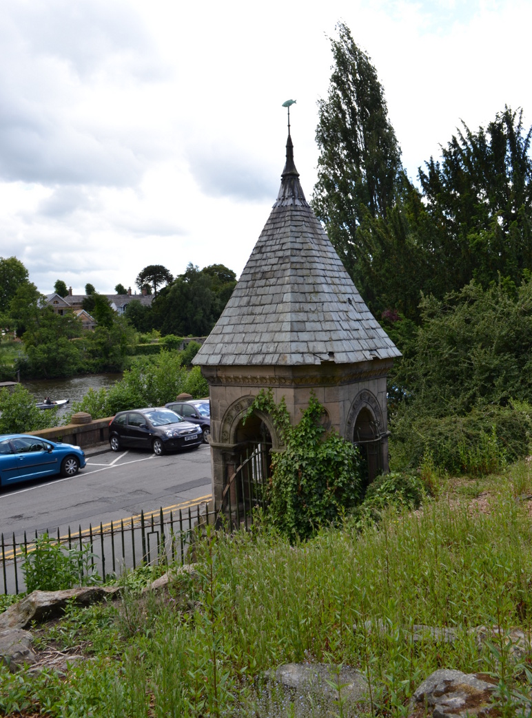
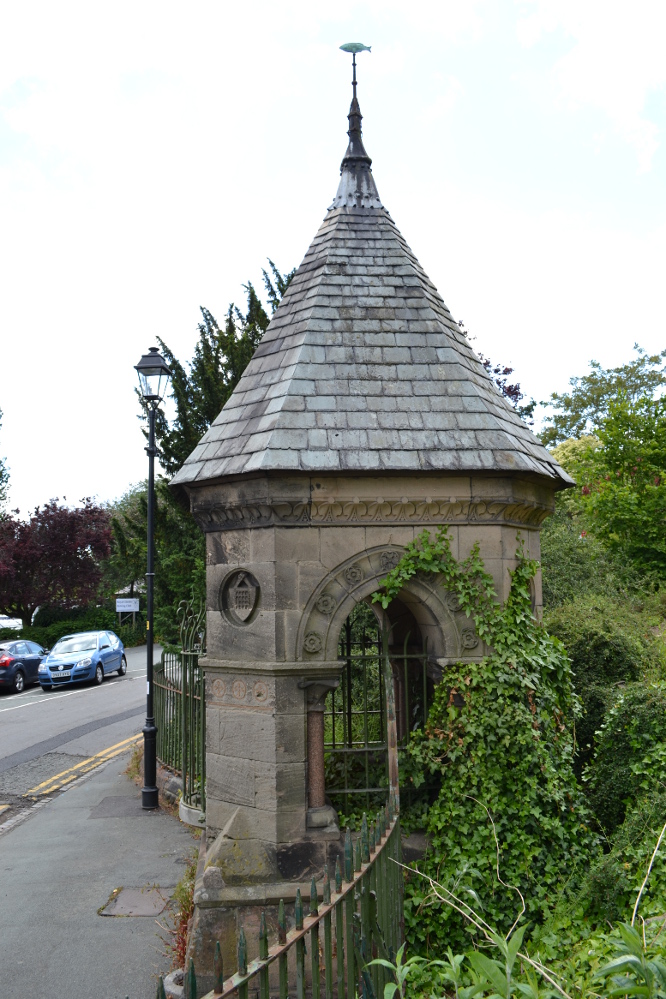
The well is found on the south-east corner edge of Grovesnor Park, which is the south-east of the city beside the River Dee.
Archaeology & History
Billy Hobbys Well, Chester
An early reference to this site is in the place-name of Billy Obbies Field, marked in 1745, with an accompanying spring marked at 1791. This would appear to suggest that the spring gained its name from the field and not vice versa, with the name possibly representing a local person. Yet the name may hide a much earlier origin. The name ‘Hobby’ derives from hobb, a name for a devil or demon – and where the name hobgoblin derives from. It may be possible that the area was a marshy waste and to warn people away a legend of a demon was introduced. More interesting is the idea that as the name ‘Hobb’ is synonymous with Puck, and Puck possibly having a Roman origin, that the site could be a much earlier Pagan site. This might explain the fertility ritual found here (see Folklore, below) if it has a greater age. It may be significant that when the park was developed, a long line of Roman earthenware water pipes were found. Did they draw water from the spring?
Internal Structure
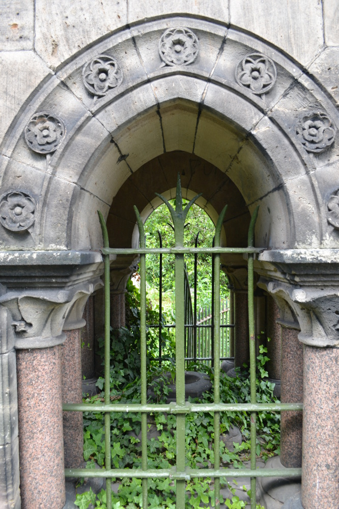
Whatever the origin, when the garden was developed in the 1860s by the 2nd Earl of Westminster, Richard Grosvenor, a rather grand and impressive red and buff sandstone ashlar well house was erected. This was designed by John Douglas, a local Chester architect, who was not forthcoming in making this well grand with canted corners, pointed arches flanked by a granite columns with wrought iron bars. At each corner is a small carved circle containing carved sheafs and portcullis and the voussoirs contain carved roses. A tiled spired roof sits upon the structure with an apex surmounted by a copper fish weathervane. All in all, rather ostentatious for a well – especially as access to the well chamber has not been made very easy by the enclosure. Whether the improvements were done to develop some sort of spa well is unclear, but it is known that the when Canniff Haight (1904) visited for his United Empire, the spring was still flowing and noted, for he records:
“Billy Hobby’s Well,” a spring of excellent water, where we have a drink.”
Folklore
This was a local wishing well. A local anonymous rhyme records:
“I lov’d the tales that idle maids do tell,
Of wonders wrought at Billy Hobby’s Well,
Where love-sick girls with leg immured would stand,
The right leg ’twas – the other on dry land,
With face so simple – stocking in the hand –
Wishing for husbands half a winter’s day.
With ninety times the zeal they used to pray”
This old rhyme despite some pedigree suggested I have been able to date only to 1823. It appears to record a ritual undertaken at the well, a similar ‘one part of the body in, one out’ was done at Walsingham by lovelorn maidens, but it does look to be Victorian in origin there (or at least post Reformation). The only problem with the practice being undertaken then is that the present structure dates from that period.
From the forthcoming work on Holy wells and healing springs of Cheshire
References:
Dodgson, J.M., The Place-Names of Cheshire – Part 5, English Place-Name Society: Cambridge 1981.
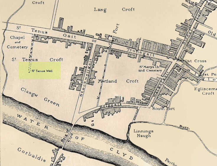
Whilst I’m in Glasgow (big thanks to Aisha!) I thought I’d check out any remaining heathen sites that might still be visible. Many have perished of course, beneath the weight of religious industrialism—this one included. Even when the Ordnance Survey lads came here in 1858, it had already been destroyed. All that we now know of it comes from the writings of the earlier historians like Walker (1883), Renwick (1921) and co.
Known in early records as St. Theneu (mother of the legendary St. Mungo, who also had sacred wells dedicated to him in Glasgow, Gleneagles and much further afield), trackways and burns hereby were also named after this curious character, and a chapel was also commemorated to her, which fell into ruin several centuries ago. Its position was highlighted on a late-16th century sketch of Glasgow village—as it was then—immediately south of the chapel, just north of the River Clyde. The best description we have of it comes from a detailed paper on the holy wells of Glasgow by a Mr Brotchie (1920), who told:
“Where the subway station of St. Enoch’s Square stands…there was at one time the well of St. Tenew, the mother of St. Kentigern or Mungo. It is thus described by a writer in 1750, “The ruins of a small chapel stood beside the well whose waters were sheltered by a bush, on which were to be seen, especially in early summer, bits of rags of all kinds and colours, while in the well itself enterprising boys were wont to get small coins. The rags and the coins were the offerings of people, principally women, who came to drink of the waters of St. Tenew’s Well, and left these trifles as thank offerings.”
“This ancient well of St. Tenew stood near a chapel erected over the tomb of St. Tenew, and the ground in its vicinity remained sacred in the eyes of the faithful as the last resting place of the holy woman who had watched the infant steps of the great apostle of the Cambrian Britons, St. Mungo, the patron saint of Glasgow. The Trongate and Argyle Street, which now stretch westwards from the cross, were in old times a country road leading to St. Tenew’s chapel, kirkyard and holy well. In a deed of 1498 mention is made of “the blessed chapel where the bones of the beloved Tenew, mother of the blessed confessor, Kentigern, rest.” When M’Ure wrote his History of Glasgow in 1736, the remains of this old chapel and kirkyard were described as standing “in a solitary spot in the country surrounded by cornfields.” Looking westwards from St. Tenew’s Well in 1750, a writer describes the scene as “open country, pastures and cornfields, rude-looking country homesteads, barns and other farm buildings, and enclosed kailyards,” where now stand the busy arteries of Jamaica Street, the Caledonian Railway Station, and the miles of tenements that stretch westward to Anderston, Finnieston and Partick.
“We have a comparatively recent record of the holy well of St. Tenew in the statement of the late Mr Robert Hart, who told M’George that he had been informed by an old man, a Mr Thomson, who had resided in the neighbourhood of St. Enoch’s Square, that in the beginning of the last century, say 1800, he recollected the well being cleaned out, and of seeing picked from the debris at the bottom many old coins and votive offerings. St. Tenew’s Well was a holy well. For centuries it was a place of pilgrimage and was much resorted to for cures, especially in pre-Reformation days. In 1586, James VI, addressed a letter to Mr Andrew Hay, commissioner for the west of Scotland, condemning the practice of people making pilgrimages to wells and chapels, but the royal edict was powerless to stop the practice and St. Tenew’s Well was resorted to by people in trouble as long as it was in existence. The road that led to it was known up to the 15th century as St. Tenew’s Gait or path. Indeed, it was so named till 1540, when the name of Trongate begins to make its appearance in old city deeds. This name, of course, owes its origin to the granting in 1490 by James IV, to the Bishop of Glasgow of the privileges of a free tron in the city—hence our Trongate of today.”
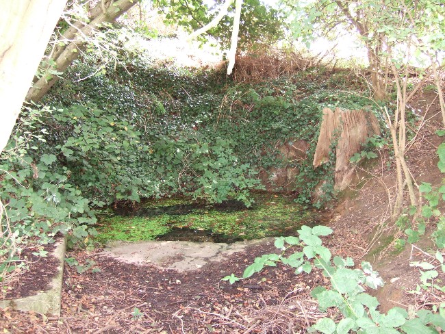
The Runwell (copyright with permission http://www.spiritrealms.co.uk/gallery.htm )
It can be found by taking a road off the A132 (Wickford Road) which leads to Stock (directly opposite the Parish Church), continuing until you reach another minor road to Rettendon. A short way up this road it forks. Take the road to the right & continue until one reaches a minor drive to Poplars Farm (distinctive with its trees each side of the drive). Continue up here until one passes the house to a small piece of tarmac. Here a footpath continues directly in front, continue until one reaches on the left a gate. Enter through here, and head across the field towards a notable tree, and a gap in the hedge. To the left, follow the edge of the field, until one sees another opening into the well. The approach from the south is the only route worth considering as northerly access is blocked by a fence. It can be extremely muddy, so good footwear is advisable.
Archaeology & History
Philip Morant (1763-8) is the first to mention it, suggesting that the settlement is named:
“..from a considerable Running well in the Parish.”
Again, Chandler (1896)—noted in Collins (1986)—emphasises:
“a remarkable spring of water on Poplars Farm, which is always running and has never been known to fail.”
Despite this obvious assumption, Ekwall (1936) suggested that the prefix originates from O.E rune for ‘mystery’ or implying a well possessing a secret of some religious observance. This is suggestive of the strange legends and traditions involved with the site. Alternatively it could derive from hruna referring to the tree trunk—and it does arise in a copse. A roman road runs by here.
The only reference to a religious site appears to be in 1602 when the parish register records ‘Shrine of the Bl. Virgin of RunnyngeWelle’. However, stone remains found over the years around the well may support the idea of a well chapel; these remains were two pieces of limestone window mullion and a piece which appears to be part of a step as well as pieces of Kentish ragstone.
Folklore
According to Bazille-Corbin (1940), Runwell is steeped in lore and legend. One must take these stories as possible antiquarian fancy as there does not appear to be any concrete evidence for them. Doubtless some of it is true, other bits not. He states that in the Sixth Century AD, Christian missionaries Lucus and Lucilus visited Essex and found a scene of paganism here, built a chapel, and rededicated the well to “Our Lady St Mary.” The floor of this chapel had a unique designed cross, with black flint and red strawberry stone, to show the teachings of the tenets of the Christian Faith.
To protect this and collect subsequent devotional gifts, a nunnery, of six members, was developed around the site. They tended to the shrine, well head and the statue of Our Lady, to which many miracles were attributed. Little evidence exists concerning this foundation, but it is believed to have been dissolved in the 16th Century. Locally it is said parts of the nunnery were incorporated into the nearby farm-house ‘The Poplars’. In the 1980s, Andrew Collins, searched for records of this local priory, but found none.
Another legend connected with the well accords that a young nun, Sister Lucy, after renouncing her vows, found the outside world not to her liking and returned in repentance, one snowy night, to the chapel for forgiveness. Yet, upon reaching the chapel steps, she slipped and fell into the icy waters of the well. (cf. The Single or St. Thomas’ Well at Ifield, Kent)
Her ghost is said to haunt the area, preserving perhaps the memories of these past water deities. This is enforced by the belief by some authorities that the well’s dedication indicates a Christianisation of the Iceni goddess Epona. This is supported by these horseshoe-shaped motifs, and that the approach to the well being haunted by a horse.
Andy Collins (1986) was informed that a concrete water tank was installed over the spring. This proved to be inaccurate, but the well was defined by a concrete chamber. Collins thought that this may be the remains of some adaptation for a spa bath, but no hard evidence was forthcoming regarding this.
It certainly had passed through considerable years of neglect, as noted by the Runwell Rector John Edward Bazille-Corbin (1942), who said it was “in much need of dredging and cleaning out.”
The photo shown in Collins’s (1986) work shows a concrete lined rectangular pond, defined by corrugated iron. He was thus responsible for its repair and clearing away the years of neglect, also revealing the concrete rectangular pond, which was reached by a series of steps from its north side. A flight of steps appear to enter the well itself from the front. The body of water is of considerable size and depth and one could easily immerse oneself in it. When I last visited here, the water appeared murky but a sample revealed (apart from the pond fauna) a remarkable clarity.
Within recent years the well appears to have attracted a ‘cult following’, clearly manifesting itself in two ways. One is a seasonal Boxing Day walk to the well started in 1975, which is still undertaken (see link, below). The other more traditionally is the attachment of rags or cloutties to the surrounding shrubbery. Such activity, although probably done by those ‘in the know’ rather than any continuation of any local tradition, is the only such example I have come across in East Anglia—although recent photographs fail to show this and it appears that the tree has been cut down where these have been placed and the area opened up.
References:
Bazille-Corbin, J. E., Runwell St. Mary: A farrago of History, Archaeology, Legend and Folk-lore, 1940.
Collins, Andrew, “Devilish Mysteries at Runwell,” in Essex Countryside Vol. 33 no.431, p38-39, 1985.
Collins, Andrew, The Running Well Mystery, 1986.
Ekwall, Eilert, Studies in English Place and Personal Names, Lund 1931.
Ekwall, Eilert, The Concise Oxford Dictionary of English Place-Names, Oxford 1936.
Morant, Philip, The History and Antiquities of the County of Essex – 3 volumes, London 1763-8 (reprinted by EP: Wakefield 1978).
Holy Well (destroyed): OS Grid Reference – TQ 6538 7081
Also Known as:
St. Thomas’ Well
Shingle Well
Archaeology & History
Sadly the site is gone no longer in existence it was in the roadway along the Roman Watling Street, at its junction with Church Lane, where it joins the relatively recently named Hever Road with Mailings Cross.
Local opinion, erroneously believes that its name derives from there only being one well in the district, but it originates from its substrate, being once called ‘Shinglewell’ describing the substrate. It ended its days as a traditional winch well, with a depth of 150 yards. Watt (1917) described the draw well as having a sign, reading ‘This water is not fit for drinking’— the result of contamination by a nearby stagnant pond. This wooden framework was removed during the First World War, when the well was filled in and domed over. Later, in 1935, a granite slab inscribed with: ‘Site of the Ancient Well, Singlewell Parish or Ifield’ was placed there. Unfortunately, this was removed by the County Council in 1952, and along with the combination of road improvements, the site was largely forgotten.
Folklore
Recorded in a Latin MS and translated by the Rector of Ifield between 1912-1935, the Rev K. M. Ffinch tells of a tradition in great detail, and the following is a brief resume. The legend involves a village girl called Salerna, who is said to have ‘thrown’ herself down the well after being accused of stealing some cheese. Yet, as she fell, she cried out for St. Thomas to save her from her impending doom, and upon finishing her plea, landed on some planks lying at the bottom of the well. They broke her fall, and thus saved her from her dreadful fate. She was then subsequently rescued and because of the ‘miracle’ the well was dedicated to the saint.
The incident is said to have occurred soon after St. Thomas’s martyrdom, and is said to have been one of his first miracles. The name ‘Salerna’ suggests a Roman origin, supported by its location along Watling Street, a Roman Road. Bayley (1978), using a low-land British dialect, which he believed survived until this century, states that ‘Salire Naias’ is ‘the water nymph, who springs forth and runs down’. Consequently, the story of St. Thomas miracle may have been introduced to remove the pagan tradition and refocus the beliefs of the people using a local saint.
References:
Bayley, M.,(1978) Ancient, and Holy and Healing Wells of the Thames Valley, and their Associations.
Ffinch, K.M., (1957) The History of Ifield and Singlewell
Parish, R.B., (1997) “The Curious Water-lore of Kent II: Ghosts, Fertility and Living Traditions”, in Bygone Kent, Volume 18, pp.427–32.
Watt, F., (1917) Canterbury Pilgrims and their Ways
(Extracted from the forthcoming book Holy Wells and Healing Springs of Kent)
Often noted under Lower Burnham, although this is a hamlet and not strictly the parish, is in Haxey. The spring can be found by taking the footpath after Starkey’s farm, top of Holy Well lane, with Holy Well House the nearest dwelling.
Archaeology & History
Holy Well, Haxey
Potentially if Hunt (1923) quoted in Hills (1967) is to be believed, this is the most famed holy well in the county, as he believes that this was the site where King Oswald—later St Oswald—was slain and here the well was St Oswald’s Well rather than at Oswestry. He notes that:
“The Holy Well at Lower Burnham in the parish of Haxey is supposed to mark the site where King Oswald fell. People took away the soil until a deep hole was formed which filled with water…It has been known for 1300 years as the Holy Well, and annual feasts were held near it until recent years. This confirms the Ven. Bede’s statement about the sanctity of the soil in the eyes of the people.”
According to Garner (1991) by the early 19th century the well’s popularity had waned and the spring fell into private ownership and the water was used to run two water mills, and as such a gully of considerable depth constructed. However the spring did not produce enough continuous water and the scheme failed. A similar attempt was made by Rev. Thomas Skipworth Rector of Belton was more successful but only because a dam was constructed although still the power was not great enough. Interest in the well had not completely disappeared, and an announcement in 1875, in the Epworth Bells stated:
“Firmly believing in the efficacy of the Burnham water in the cure of some outward bodily complaints, we sometime since urged the importance of making that water once more available to the public, and at the same time we urged the desirability of the public availing themselves of the water.”
Responding to this plea, a group of local men, Cooper, Starkey, Ducker, Skelton, Meggitt and Templerton came together to ‘re-open the well’ It had been for years only a dry, roughly rectangular, hollow but ‘within minutes of digging, water gushed out, and the hollow filled.’ No evidence of constructional material was seen but the landowner, Mr. Lockwood, agreed to allow the well to be kept open and the water to be freely available when he did not have cattle in the field, as such the well was fenced in probably as local people reported in the Crowle Advertiser (1960) with white railings. Indeed, up until the 1940s the well remained fenced off with barbed wire as a cattle water place and at some point it was filled in.
This meant that the well had again fallen into disused and its exact location was perhaps becoming unclear, when in the 1960s when three Epworth men, Frank and David Lindley with Jack Warriner. A report in the Crowle Advertiser of 1960 noted that:
“At a spit depth, what seem to be known locally as water stones began to be turned up; at about two feet six there was a promising slab, followed by another, at a little deeper level; and after discovery of several hand-made bricks had dispirited the diggers somewhat, three more irregular shaped stones of considerable size were scraped clean of the mud that overlaid them. By now there was bared to view what could have been the stepped entrance to the well which from visual testimony of old residents, the explorers hoped to find.”
This stepped entrance consisted of eight steps according to local people. The group then discovered at about four feet timber was found and on this two corner stones were found rested. This was thought to have been the remains of the enclosure which went around the well.
In March 1961 another attempt was made to open the well in view of a pilgrimage by the Lincoln Diocesan Youth Pilgrimage, this time the excavators had gone twice as deep and the strata of waterstone was hit, but no evidence of a constructed well. This was not a concern of the Vicar of Owston Ferry, Canon L. D. Ravins who was of the opinion that an actual construction would have been unlikely if the above description by Hunt was to have happened. This time according to the Crowle Advertiser:
“Both he and Canon Ravins feel that the water may well have medicinal qualities (they noticed they say an unmistakably sulphurous smell from it during the excavations) and they are intending to have the chemical analysis made.”
However, the analysis did not reveal any sulphur but it did have Magnesium and Calcium sulphates and Calcium bicarbonate all linked to spa waters and hence verifying its medicinal role. The well was visited by the pilgrimage and Garner (1991) recollects that a white timber enclosure was placed around the site with a sign proclaiming ‘The Holy Well’ according to him the ‘whole site now barely discernible save for a lone willow sentinel-like over the place revered by myriad generations in days long since past.’
However, this was not the case when I visited the site and found a large pool with a pipe at one end, from which a channel appeared to flow. Although Garner (1991) noted a ‘few elder citizens of Burnham strongly favour its position a few metres south of the spot popularly referred to”.
Folklore
However this name has not been recorded and the site is best known simply as the holy well. This site was, according to Gutch & Peacock (1908),
“ …dedicated to the ever-blessed Redeemer, and on the festival of His Ascension was supposed to possess the power of healing all sorts of deformities, weaknesses, and cutaneous diseases in children, numbers of which were brought from all parts to be dipped in it on that day.”
The earliest mention appears to be Peck (1809) who stated:
“a Spring called the Alley Well of very cold water which was very much resorted to by the people in their neighbourhood, being very proper for those of a weakly habit.”
Stonehouse (1839) notes:
“about one hundred and twenty years ago, the concourse of visitors was so great that a Village Feast was held at the same time… and at a much later period conveniences were annually made for the use of the bathers, and gingerbread-stalls and other slight reflections were provided on the spot. This practice has, however, of late years fallen altogether into disuse… The spring now appears in a dirty and neglected state.”
The fame of the spring led to it being immortalised in Hamilton’s novel Captain John Lister where the titular hero watches during the early morning of Haxey Fair, a melancholy procession through the main street of women, accompanied by diseased and deformed children. In the book, the innkeeper explains by saying:
‘They are going to the Holy Well at Nether Burnham. ‘Tis a famous spring, and has been many ages, and on this day there is virtue in the water to cure almost any disease or sickness in a child, if be dipped before noon…out of Nottinghamshire and Yorkshire and I don’t know where all.’
(Essay taken from R.B. Parish Holy Wells and healing springs of Lincolnshire)
References:
Garner, J. R. (1991) Burnham – the story of an Axholme village.
Gutch, E. & Peacock, M. (1908) Country Folklore Vol. VI: Folklore of Lincolnshire
Hills, P.J. (1967) The Holy Well of Burnham the site of the Battle of Maserfield-the identification re-examined.
Stonehouse, W.B. (1839), The History and Topography of the Isle of Axholme.
Various anonymous cuttings from Crowle Advertiser (1960)
The 6″ OS map of 1913 has a ‘Fairy Well’ marked on the northern edge of Preesall Hill. Travelling north through the village on the B5377, the Hill is to your right. Immediately past it is a stile, cross over this and go straight on with the hill to your right. The approximate site of the fairy well is now marked by a boggy area at the foot of the hill.
Archaeology & History
Almost a footnote in Reverend William Thornber’s 1852 paper on the Britons, Saxons and Danes in the Foreland of the Fylde, here is how this site is described by him in the quaint (to our eyes) language of the mid-nineteenth century:
“…the hill of Presal, (the ‘Pressonde’ of Domesday), with its well all but deified; and although the votaries, like those in the pool of Laconia, may not have cast into it cakes of bread-corn to Juno,* yet a bush was named ‘Beggar’s bush,’ from the circumstances of the offerings of rags and clouts being affixed to it, over which a prayer was said; for Bishop Hale ridicules a superstitious prayer for the blessing of clouts for the cure of diseases.”
In addition, the following reference was found on-line:
“…If the travellers had lingered, however, they would observe the inhabitants placing half eggshells on the edge of the Fairy Well at the foot of Preesall Hill; a practice of the local school children even at the beginning of the 20th century. Recording some of the traditions of the country areas of 19th century Wales, Sir John Rhys in his “Celtic Folklore”, mentioned how half eggshells were left out for the fairy folk to use as cooking pots in which to prepare food and brew beer for the reapers at harvest time.”
Close-up of the boggy waters
The Beggar’s Bush is long gone, but the red colour of the deposits in the adjoining ditches would indicate a chalybeate (iron-bearing) spring rather than a well, and the northern slope of the hill seems to have become an unofficial children’s play area. Curiously, at the top of the hill, next to the playground of the Fleetwood’s Charity School, there is a modern ‘beggar’s bush’, festooned with white and yellow plastic strips, in a small nature trail area…
* quoted from Borlase, in his Natural History of Cornwall (1758): “…In Laconia they cast into a pool, sacred to Juno, cakes of bread-corn; if they sunk, good was portended; if they swam, something dreadful was to ensue.”
¶ http://www.lancastrians4ever.homecall.co.uk/lancastrians4ever/precha1.htm – Believed to be an online digest of out of print Preesall history publications by Stan Jones
References:
Thornber, William, ‘Traces of the Britons, Saxons and Danes in the Foreland of the Fylde,’ in Proceedings and Papers of the Historic Society of Lancashire and Cheshire, Liverpool 1852.
Acknowledgements: – My thanks to the staff of the Local Studies Department, Borough of Blackpool Library Services for their assistance