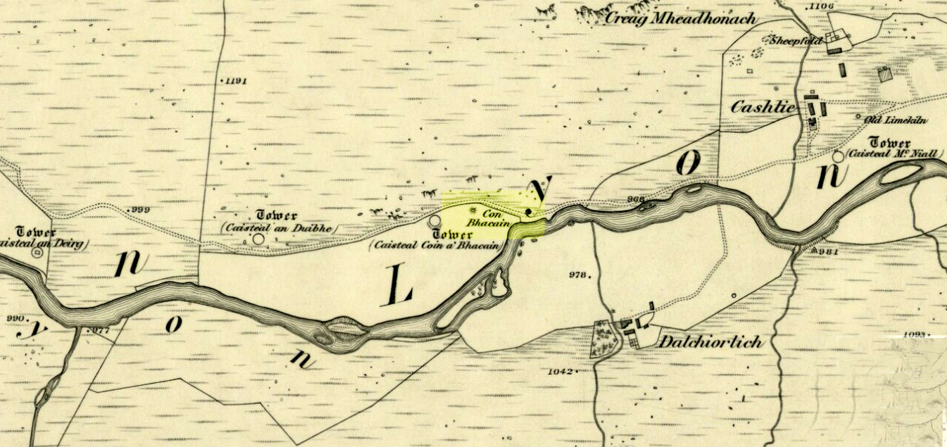
Whether you take the road west from Fortingall, or over the heights from Loch Tay, when you reach Meggernie Castle just keep going west for a few more miles. Keep going past the large Stronuich reservoir on your left and you’re getting close. Go past Caisteal Mhic Neill and the trees at Cashlie House for another 5-600 yards and where the track crosses the river Lyon, park up just past it. Ahead of you in the field on the left of the road, nearer the riverside, is where you need to look.
Archaeology & History
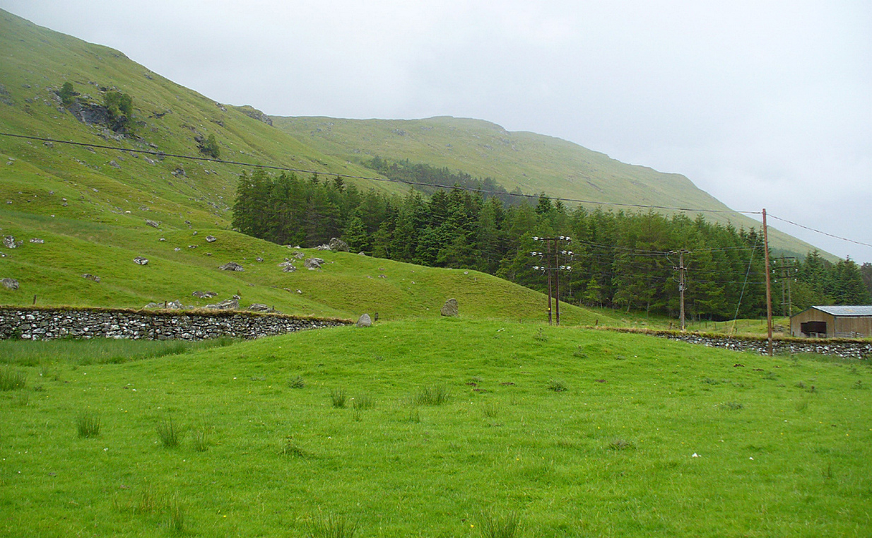
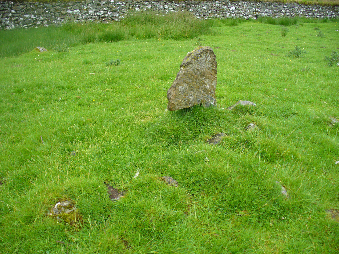
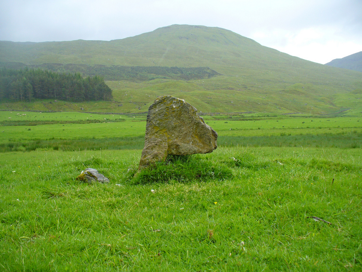
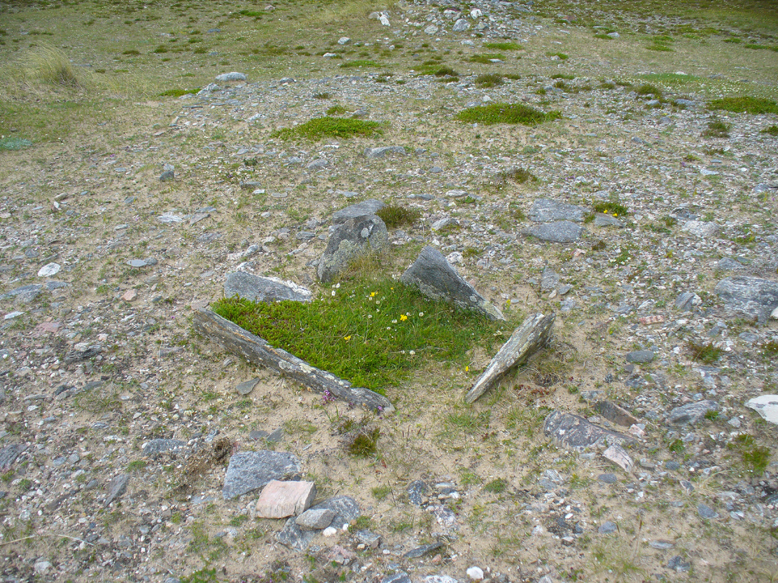
One of the most peculiar and unique sites in the British Isles is this remote small upright stone, known locally as The Bhacain. Standing upon a small mound in the field immediately east of one of Finn’s legendary ‘forts’ (a dun or a broch) called Caisteal Cona Bhacain, this curious monolith, less than two feet tall, has a thin upright stem with a much enlarged rounded end to it. Some might even ascribe it as phallic—although local traditions of the stone relate it as a truth-sayer of a young girl’s virginity!
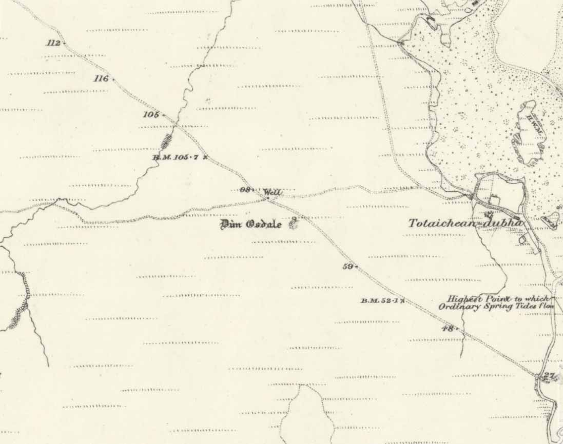
The Bhacain on 1867 mapMound of The Bhacain
Its position on top of the small mound is intriguing, giving it the impression of being atop of a tumulus; and there is also the scatter of small stones surrounding the upright just beneath the surface (as evidenced in one of the photos), making it possible that the stone is an ancient burial marker. If this is ever shown to be true, the likelihood is that the stone marks the grave of a hound, as the tradition of this spot implies. No excavation has ever occurred here, so the precise nature of the stone (and the mound) has yet to be ascertained; but knowing the longevity of some oral traditions in these Highland glens, the idea of it being the burial-place of a dog is anything but far-fetched.
If the stone is contemporaneous with the associated ‘duns’ close by, this would be a late standing stone, probably erected in the Iron Age. We can certainly see, quite plainly from the erosion on the stone, that this is not neolithic or Bronze Age in origin. A decent examination of the important sites hereby is long overdue…
Folklore
The Bhacain & its stony pile
The folklore and traditions attached to this site are numerous when you consider how small it is. Much of this relates to the fact that animistic cosmologies in the Highlands were retained until very recently, stretching way back. Accounts from the 19th and 20th centuries tell of people still frequenting this and other sites, at sunrise, or full moons, as such things were still very much integral parts of rural life. When the local historian Duncan Fraser (1973) wrote about The Bhacain in his fine work on this area, he told much about the traditions of the great warrior King Fionn and his activities hereby:
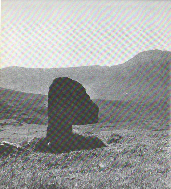
Duncan Fraser’s old photoThe Bhacain, looking S
“Another traditional link with the warrior King is the Bhacain, on a mound beside the road, far up the glen. Only a stone’s throw from one of the forts, it is about two feet high and shaped like the head of a dog. This is said to have been the stake to which the Fians tethered their staghounds with leather thongs, when they returned from the chase. And there were times, no doubt, when Fionn’s own dog, Bran was among them, with its yellow paws and its black flanks and its chain of pure gold. It was the best hunting dog that ever lived. And there was its brother, the dreaded Grey Hound, that used to roam on its own in the Great Glen, tearing its victims limb from limb, until it too abandoned its wildness and became one of the hounds of the Fians. They say that the dogs’ food was thrown to them from the top of Caisteal Coin-a-bhacain, the castle of the dog’s stake, upwards of seventy yards to the west. And any dog that failed to catch its supper was turned out of the pack.
“Time did not allow the Bhacain to become inanimate like other stones. Even in comparatively recent times it was still regarded with superstitious awe. A retired schoolmaster of Fortingall recorded eighty years ago that it was said to have a mysterious effect on those who crept under its head. And old folk in the glen will tell you that those who did so were girls. It had become the glen folk’s yardstick of virginity. In the late eighteenth century, when the girls returned from gathering the harvest in the ungodly Lowlands, under the stone they went. It was better than all your modern pills.”
In Hilary Wheater’s (1981) fine work on the history of the region, he told that “no youth was permitted into the fighting body of the Clan until he could lift the Bodach Stone onto the boulder beside it.” This tradition gave the Bhacain another name, the Testing Stone of the Fianna.
References:
Burke, Peter, Popular Culture in Early Modern Europe, Scolar Press: Aldershot 1994.
Fraser, Duncan, Highland Perthshire, Standard Press: Montrose 1973.
McKerracher, Archie, Perthshire in History and Legend, John Donald: Edinburgh 1988.
Stewart, Alexander, A Highland Parish; or, The History of Fortingall, Alex MacLaren: Glasgow 1928.
Wheater, Hilary, Aberfeldy to Glenlyon, Appin Publications: Aberfeldy 1981.
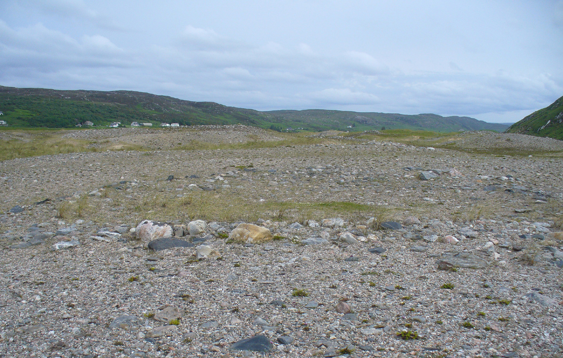
Park up and walk the long estate track up Glen Almond for nearly three miles until, on your left, you’ll see a small pond. From here, walk up the slope and, about 100 yards above you, note the large solitary boulder ahead, above the dyke of a small walled stream, where the land levels out. Just past the rock itself is the first of several remains.
Archaeology & History
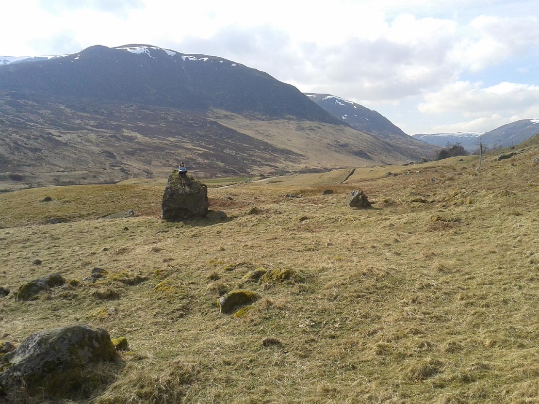
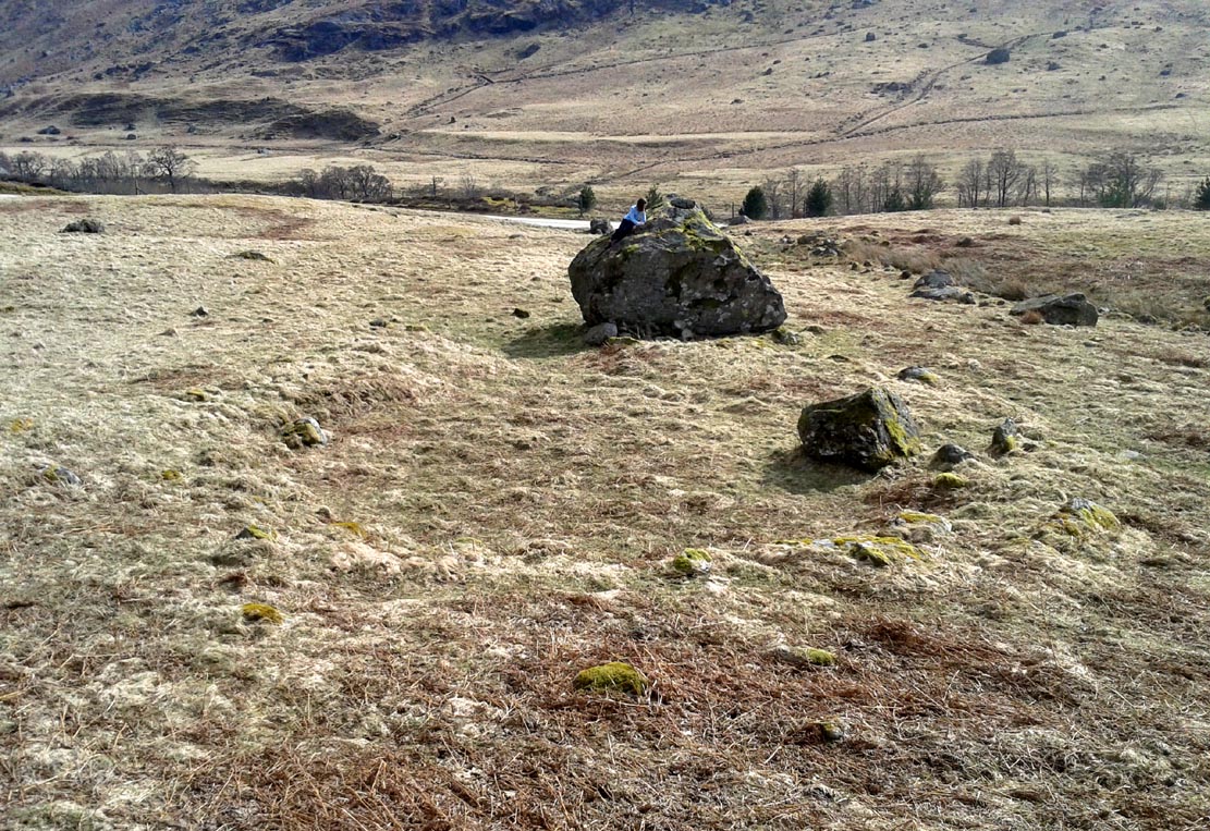
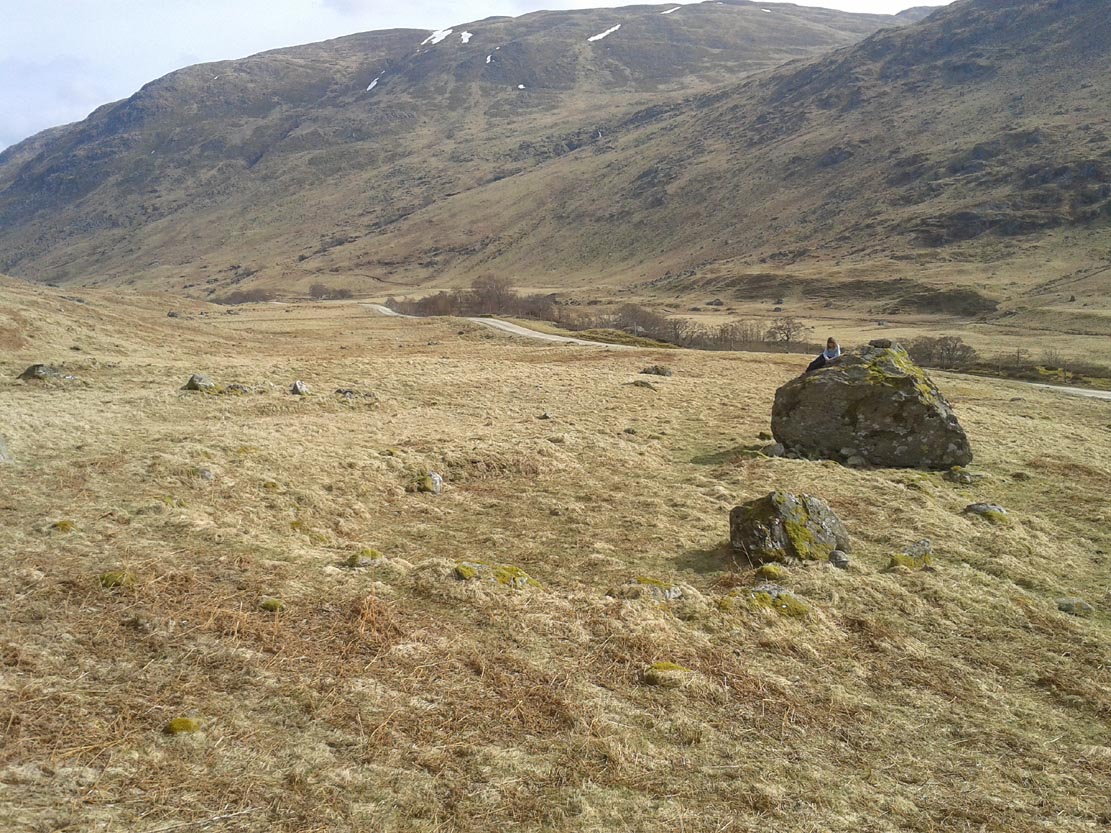
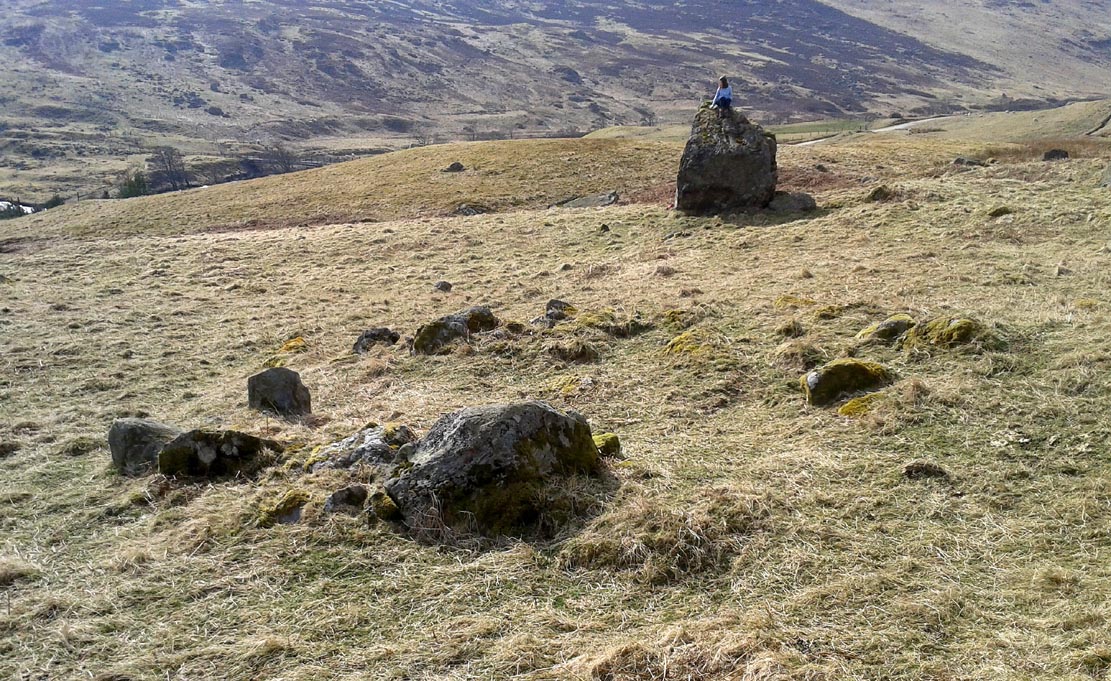
First things first: the grid-reference cited here is centred upon the largest of several rings of stone found on this small grassy plateau, 150 yards north above the River Almond, just past the huge boulder. It’s an impressive site – and a previously unrecorded one.
The raised ring of Conichan
Looking southeast
At least three large hut circles can be clearly seen on this small ridge, amidst a sea of prehistoric sites scattered all down this lonely Scottish glen. When Paul Hornby, Lara Domleo and I meandered up here the other day (to visit the Clach na Tiompan megaliths), extensive prehistoric walling called my nose up the slopes to see if anything was hiding away—and a large prehistoric ring, more reminiscent of the Derbyshire stone circles and ring cairns than any hut circle, appeared before me.
The first and largest that I came across is the one immediately north of the huge boulder (which may have slight traces of ancient walling running up to it). The large ring is clearly raised onto a flat level platform, with an entrance on its southern edge. The ring itself measures, from outer-wall to outer-wall some 12 yards wide (E-W) and 11 yards N-S. The northernmost section of the walling or stone embanked structure is built into the sloping hill to the rear, with the east and western walls constructed simply onto the flat land. The walling itself is typical of prehistoric structures, comprising the usual mass of small stones packed within a number of larger upright stones; although much of it is very overgrown with centuries of vegetation. The walling that constitutes the ring itself is between 1-2 yards across and about two-feet high above the present ground-level.
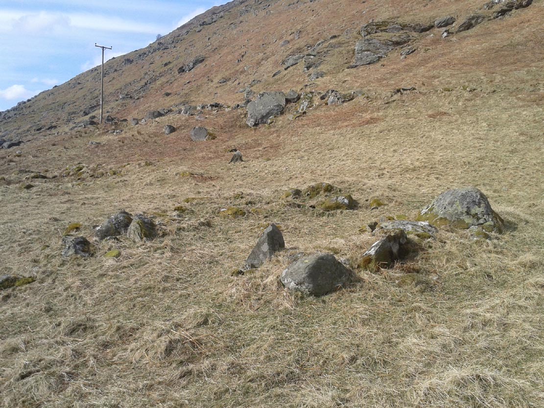
Second circular remains
…and from another angle
To the east of this is a smaller, roughly circular construction of similar form. The rocks that make up this site are much more visible and may have been robbed and used in the more extensive walling above and the dykes below. It is unclear whether the nature of this site is the same as that of the more defined circular enclosure we have just described.
The remains of a third structure was clearly evident a short distance to the east of this, but I didn’t have much time here and another visit is needed to make further assessments. Iron Age walling and other undocumented prehistoric remains were also found close by.
Acknowledgements: Many thanks to the noses of little Lara Domleo and Prof. Paul Hornby for their bimbling aid to relocate this site – and one or two others that have been off the radar for many-a-century.
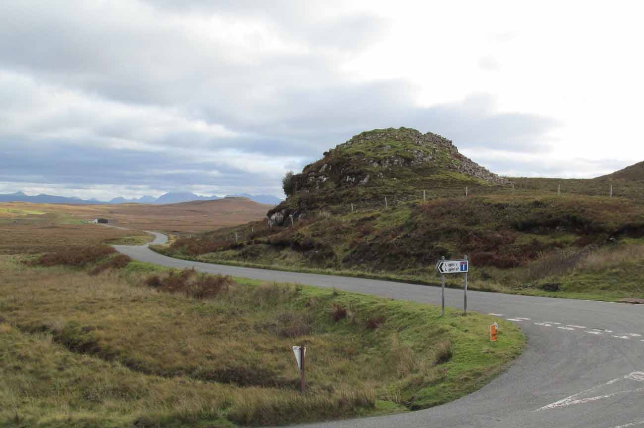
From the A863 Dunvegan road, a mile south of the village turn onto the B884 road at Lonmore, making sure you veer right after a few hundred yards and head towards Glendale. About a mile along, on the left-hand side of the road, note the small rocky crag that begins to grow just above the roadside. At the end of this crag you’ll see a huge pile of rocks, seemingly tumbling down, just by a small T-junction to Uiginish. You can’t really miss it.
Archaeology & History
Listed as one of the duns, or fortified prehistoric structures in Skye by the old writer J.A. MacCulloch (1905), the rediscovery of this broch was, said A.A. MacGregor (1930), one that “became historical only within living memory.” I find that hard to believe! The Gaelic speakers hereby merely kept their tongues still when asked, as was common in days of olde—and it was a faerie abode….
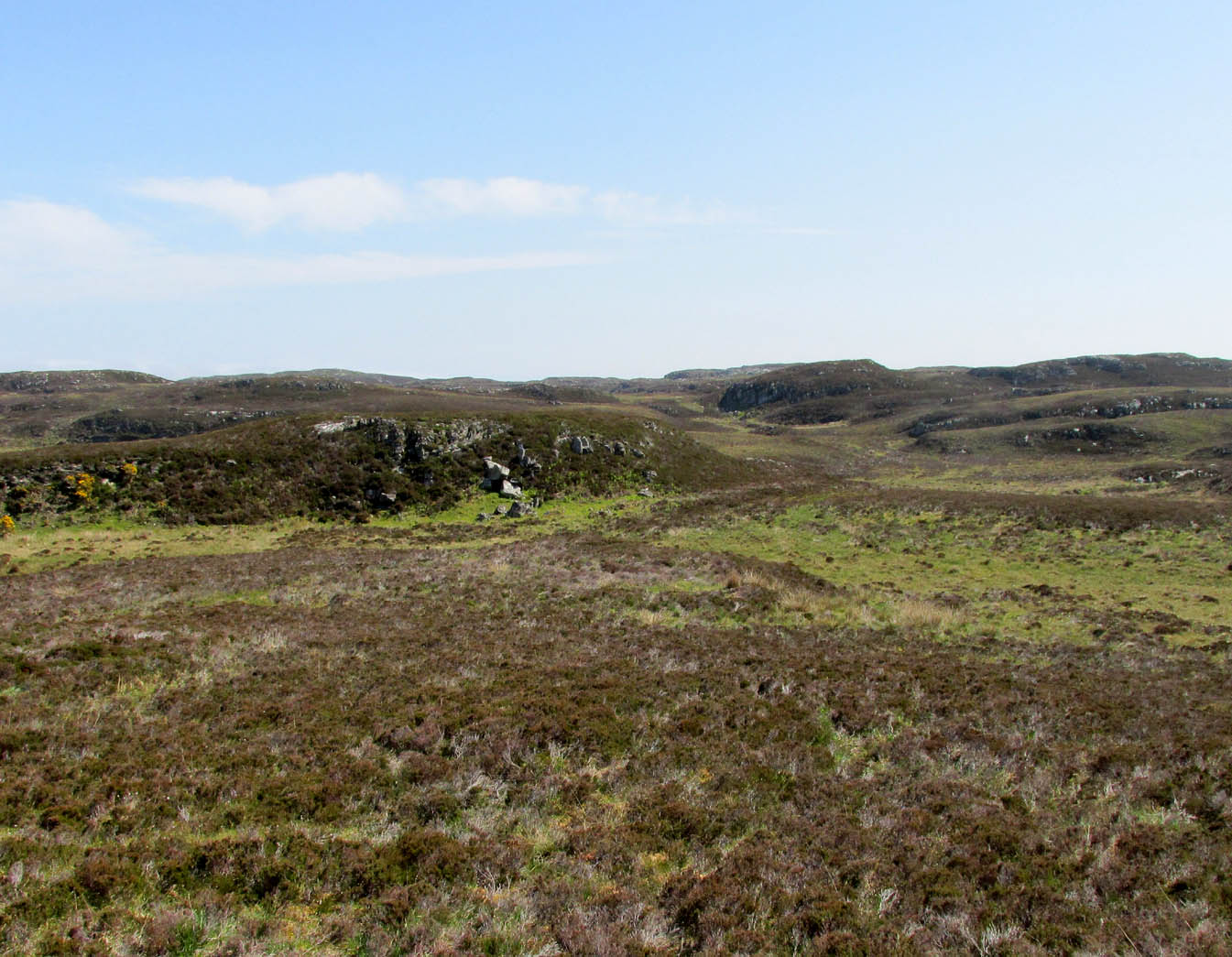
Looking at the SW walling
Looking at the SE walls
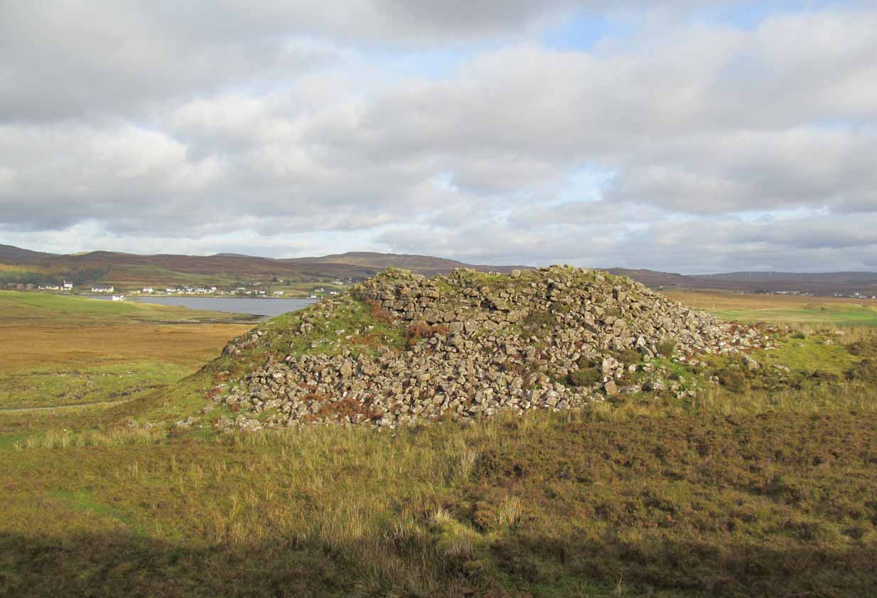
Once you go through the gate below the broch, the large boggy area you have to circumnavigate is the overflow from an ancient well, known as Tobar na Maor, where Anne Ross said, “tradition that the stewards of three adjacent properties met there.” This well was covered by an ancient Pictish stone (now in Dunvegan Castle), which may originally have been associated with the broch just above it. When I visited the site with Aisha and Her clan, we passed the overgrown well and walked straight up to the broch.
Despite being ruinous it is still most impressive. The massive walling on its southwestern side is still intact in places; but you don’t get a real impression of the work that went into building these structures until you’re on top. The walls themselves are so thick and well-built that you puzzle over the energy required to build so massive a monument. And Scotland has masses of them!
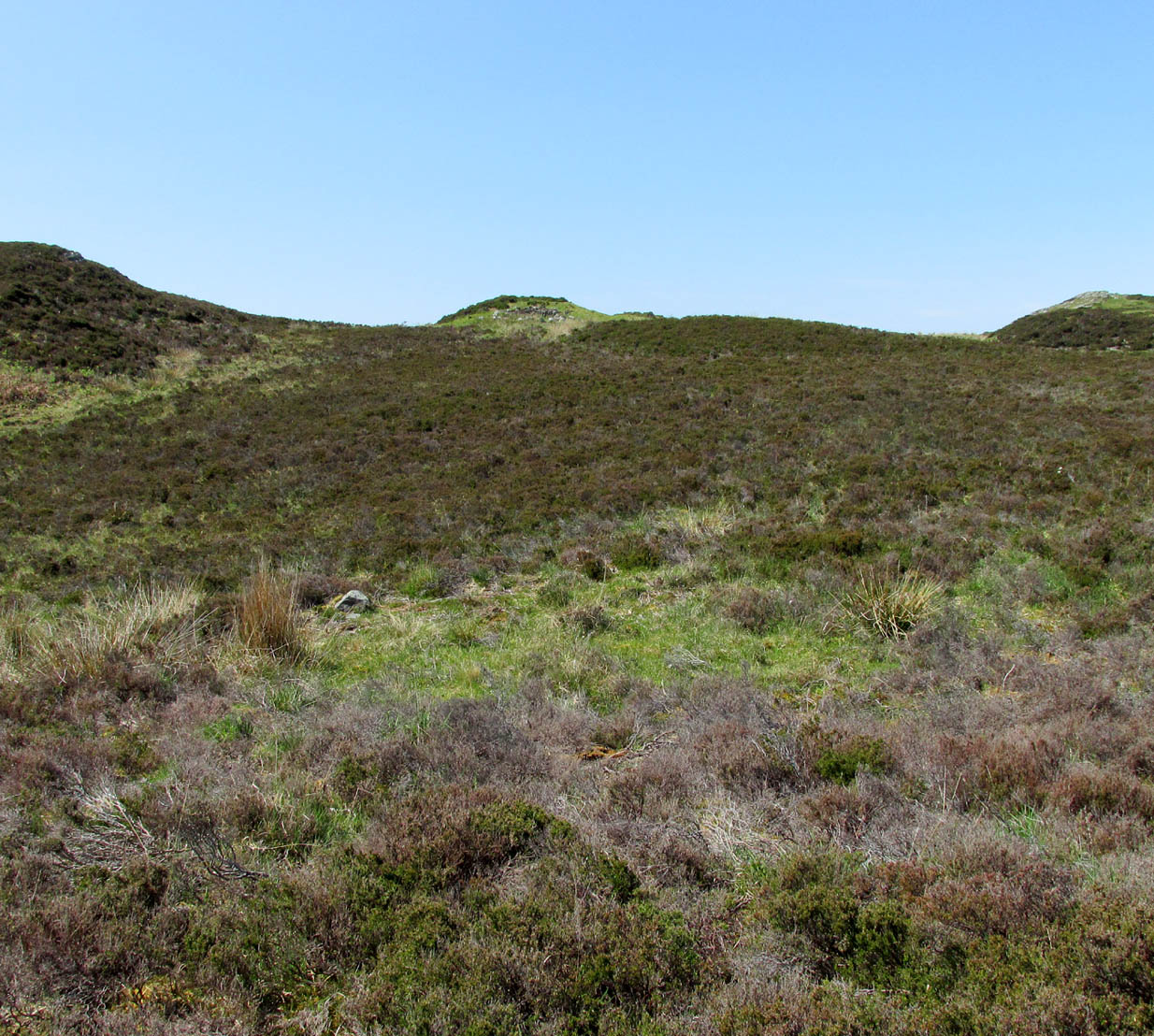
Aisha in the broch
Small internal chamber
The site was surveyed briefly when the Ordnance Survey lads came here in 1877, subsequently highlighting it on the first OS-map of the area. But it didn’t receive any archaeocentric assessment until the Royal Commission (1928) lads explored the area some fifty years later. In their outstanding Inventory of the region they described Dun Osdale in considerable detail, although kept their description purely architectural in nature, betraying any real sense of meaning and history which local folk must have told them. They wrote:
“The outer face of the wall of the broch for a great part is reduced to the lower courses, but on the west-southwest a section still maintains a height of about 7 feet; on the south-side, although hidden by fallen stones, it is about 4 to 5 feet high, and on the northeast there is a very short section 3 feet in height. The stones are of considerable size and laid in regular courses. In the interior a mass of tumbled stone obscures the most of the inner face of the wall, but on the south and northwest it stands about 8 feet above the debris. The broch is circular with an internal diameter of 35 feet to 35 feet 6 inches, and the wall thickens from 10 feet on the north to 13 feet 7 inches on the south. The entrance, which is one the east, is badly broken down, but near the inside has a width of 3 feet 2 inches, and appears to have been 2 feet 10 inches on the outside; it has run straight through the wall without checks. In the thickness of the wall to the south of the entrance is an oval chamber measuring 10 feet long by 4 feet 9 inches broad above the debris with which it is half-filled. The roof has fallen in, but the internal corbelling of the walls is well displayed. The fallen stones no doubt still cover the entrance, which has probably been from the interior. Within the western arc of the wall, nearly opposite the main doorway, is another oval cell 12 feet in length and 4 feet 6 inches in breadth over debris, with a doorway 2 feet 9 inches wide; its outer and inner walls are 5 feet 9 inches, and 2 feet 6 inches respectively. The roof od this chamber has also collapsed, but from the masonry which remains in position it must have been over 6 feet in height. Immediately to the west of the cell near the entrance are exposed the left jamb of a door and a short length of a gallery 3 feet 6 inches wide in the thickness of the southern wall, which probably contained the stairs, as traces of a gallery at a higher level than the oval chambers are seen here, the inner wall being about 3 feet and the outer 8 feet thick. Parts of a scarcement 9 inches wide can be detected on the northwestern and southeastern arcs.”
Dun Osdale plan (RCAHMS 1928)
Dun Osdale on 1881 map
Measurements and architectural tedium aside, the broch is worthwhile for anyone interested in our ancient mythic past, not least because of its position in the landscape and its visual relationship with other sites of the same period nearby. As well as that, there are unrecorded ancient sites still hiding in these olde moors…
Folklore
Tradition tells that Dun Osdale was used as a watch-tower by the tribal folk—which seems quite credible. But the original inhabitants of Duirinish, the sith or fairy folk, were also said to live here. It’s one of several places in Duirinish where the legendary Fairy Cup of Dunvegan was said to have come from. Otta Swire (1961) told its tale:
“One midsummer night a MacLeod, searching for strayed cattle, stayed late on the moor. In the moonlight he saw the door of Dun Osdale open and the little people come out, a long train of them, and began to dance on the green grass knoll nearby. Fascinated, he watched, forgetting everything but the wonderful dance. Suddenly he sneezed. The spell was broke. The dance stopped. MacLeod sprang up to fly, but the fairies were upon him and he was dragged, willy-nilly, into the dun. Inside, as soon as his eyes grew accustomed to that strange green light associated with fairyland, he beheld a pleasing sight. A great banquet was spread on a large table carved from a single tree: on it were vessels of gold and silver, many of them set with jewels or chased in strange designs. His fairy ‘hosts’ led him to the table, poured wine into one of the beautiful cups and, giving it to him, invited him to toast their chief. Now this man’s mother was a witch, so he knew well that if he ate or drank in the dun he was in the Daoine Sithe’s power for ever. He lifted the cup and appeared to drink the required toast, but in fact skilfully let the wine run down inside his coat. As soon as his neighbours saw the cup was half empty, they ceased to bother about him but went off on their own affairs or to attend the banquet. Thereafter MacLeod watched for a chance of escape and, when one offered, slipped quietly through the door of the dun and away, carrying the cup with him.
“The fairies soon realised what had happened and started in pursuit, but he was already across the Osdale river and in safety. He hurried home, told his mother the story, and showed her the cup. Being a wise woman she realised the peril in which he undoubtedly stood and at once put her most powerful spell upon him to protect him from the arts of the Daoine Sithe, warning him seriously never to leave the house for a moment without getting the spell renewed. But she forgot to put a protecting spell upon the cup also. The fairies soon discovered the exact state of affairs and immediately laid their own spell upon the cup, a spell so powerful that all who saw the cup or even heard of it, were seized with an overmastering desire to possess it, even if such possession involved the murder of the holder.
“For a year, all went well and thanks to his mother’s care the young man went unharmed. Then he grew careless and one day ventured out without the protecting spell. A one-time friend, bewitched by the cup, had been awaiting just such a chance and immediately murdered him and went off with the prize. The fairies, their revenge achieved, took no further interest in the matter, but MacLeod of MacLeod did. The boy’s mother hurried to him with her story, and he at once gave orders that the murderer be found and brought to justice. He was duly hanged and the trouble-making cup, now free of enchantment, passed into the possession of the chief and can still be seen in (Dunvegan) castle.”
References:
Donaldson-Blyth, Ian, In Search of Prehistoric Skye, Thistle: Insch 1995.
MacCulloch, J.A., The Misty Isle of Skye, Oliphant, Anderson & Ferrier: Edinburgh 1905.
MacGregor, Alasdair Alpin, Over the Sea to Skye, Chambers: Edinburgh 1930.
Royal Commission on Ancient & Historical Monuments of Scotland, Inventory of Monuments and Constructions in the Outer Hebrides, Skye and the Small Isles, HMSO: Edinburgh 1928.
Swire, Otta F., Skye: The Island its Legends, Blackie & Sons: Glasgow 1961.
Acknowledgements: Eternally grateful to the awesome Aisha Domleo and Her little clan for getting us to this ancient haven on Skye’s endless domain of natural beauty. Without Her, this would not have been written. Also, accreditation of early OS-map usage, reproduced with the permission of the National Library of Scotland.
Faint outline of Modsary hut circle, across centre
Along the A836 between Tongue and Bettyhill—nearly 5 miles (7.75km) east of Tongue—take the minor road north to Modsary and Skerray. Some 1.75 miles along you’ll notice an inland loch to your right, and where the loch finishes, take the minor track up on your right to Modsary. Walk past the cottages, through the gate and walk diagonally left down onto the moor. A small cave is across in front of you. Head towards that, but on the flat-ish piece of heathland barely 50 yards before it, above the small burn, look around for the low circular walling.
Archaeology & History
This previously unrecorded prehistoric hut circle was rediscovered in May 2018 by Sarah Maclean of Borgie during a brief excursion here, looking at the ancient clearance village of Modsary (which appears to be Iron Age in origin). In walking onto the moor, shortly before leaving me to my own devices, she pointed out this low ring of barely discernible stones, wondering, “is this another hut circle?” (there are some on the western-side of the road from Modsary) It would certainly seem so!
Grass showing centre of hut circle
It is constructed upon what seems to be a natural platform of earth above the slow-running burn. A low ring of stone walling defines the construction: visible in parts, covered in vegetation for the most. With an entrance on its southeast, the ring measures roughly 9 yards by 10 yards in diameter; with its outer walls being less than 2 feet high all round; but the width of the walls in some places measures up to 3 feet across. It is certainly man-made and is certainly olde. It requires excavation to assess its original construction period, although based on others I’ve seen that have been dated, would seem to be Iron Age in origin.
From this to the small cave that I mentioned, a most peculiar rectangular stone construction is evident 2-3 yards below it; and heading 40 yards south, beneath a craggy hill, a line of ancient walling runs SE-NW, with a much overgrown semi-circular arc of large stones, seemingly artificial in nature. It would seem there is a lot more hiding beneath the heather hereby than official records suggest…
Acknowledgements: Massive thanks to Sarah Maclean for locating and showing me this site; and also to Donna Murray for giving me a base-camp. Huge huge thanks indeed.
There are a number of souterrains—or “earth houses” as they used to be known—in Sutherland that have been lost. Many have simply fallen prey to being filled-in or covered over. This is one such site, found in the fields between Tongue village heading out towards the sea-bridge crossing the Kyle. In a brief excursion I made to the area a few days ago, I couldn’t locate the site and no one I spoke to seemed to know anything about it. I’m assuming that the site has simply been blocked-up and overgrown, hiding beneath the green pastures above the sea-line.
Its exact whereabouts is difficult to ascertain, for when it was described in Mr Horsburgh’s (1870) excursion to the area, the location he gave for it was somewhat vague, telling:
“Between Tongue House and Kirkiboll, in a field on the right of the road, there is an Eirde house, which I opened for examination (it had often been opened before); it is now about 25 feet long, 2½ feet broad at the entrance, and widens to 4 feet at the far end, where it terminates in a circle; the sides are built with small stones without mortar, and the top covered with large flat slabs.”
This places the location of the souterrain anywhere in the fields between grid-references NC 5904 5815 to the north (near Tongue House) and NC 5901 5678 to the south. If anyone knows anything about this site, please let us know.
Nothing now remains of the prehistoric underground chamber, “eirde House” (as they were called) or souterrain, that was reported by the northern antiquarian James Horsburgh when he was exploring the sites here in the 1860s. Found near Deanside a couple of miles south of Tongue, alongside the edge of the Allt an Dionaite (Deanside Burn), even in his day there wasn’t much of it left. It was one of a number of souterrains in the region that he was shown, presumably by local people, telling us briefly that,
“Near Deanside, there were remains of the end of another (souterrain) on the bank of the burn, but it has since been washed away in a flood.”
In an exploration up the side of the burn today, I could find no remains whatsoever; although I didn’t walk too far up and have a feeling that its position would have been further up than where I got to. In a brief chat with some of the old people living in the neighbourhood, they told me they had no memory of the site.
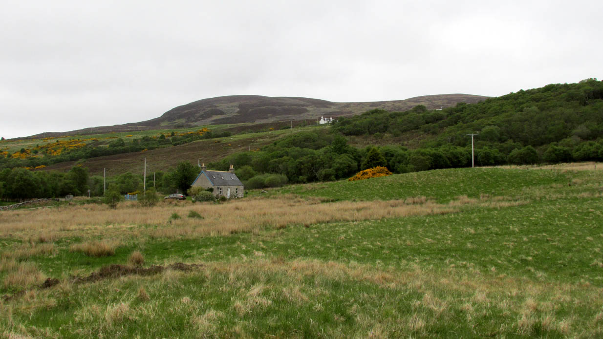
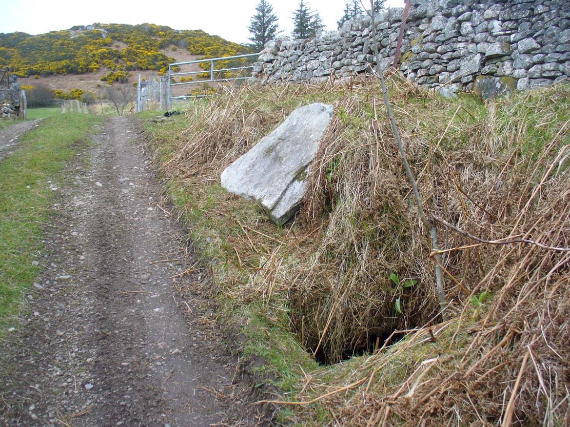
From Bettyhill village, take the A836 road west towards Tongue. Several miles along the road, keep your eyes peeled for Borgie and Skerray on your right. Go down here for half-a-mile or so until, a hundred yards or so before the Borgie Hotel, a dirt-track on your right takes you down into some trees. As you enter the edge of the woodland, right by the trackside on your left, a large stone lays in the grass. A few yards from this is the hole in the ground.
Archaeology & History
When I was first shown this place, I could find no previous description of it in any of the archaeological records. I was fortunate in being taken here by one of the land-owners hereby, who told me that it had been known about locally for some years – but informing the archaeologists (patronizing as they were to the people hereby, as can be the case sometimes) was the last thing on their minds….
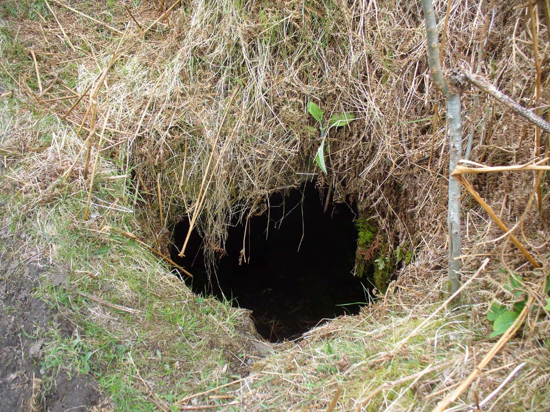
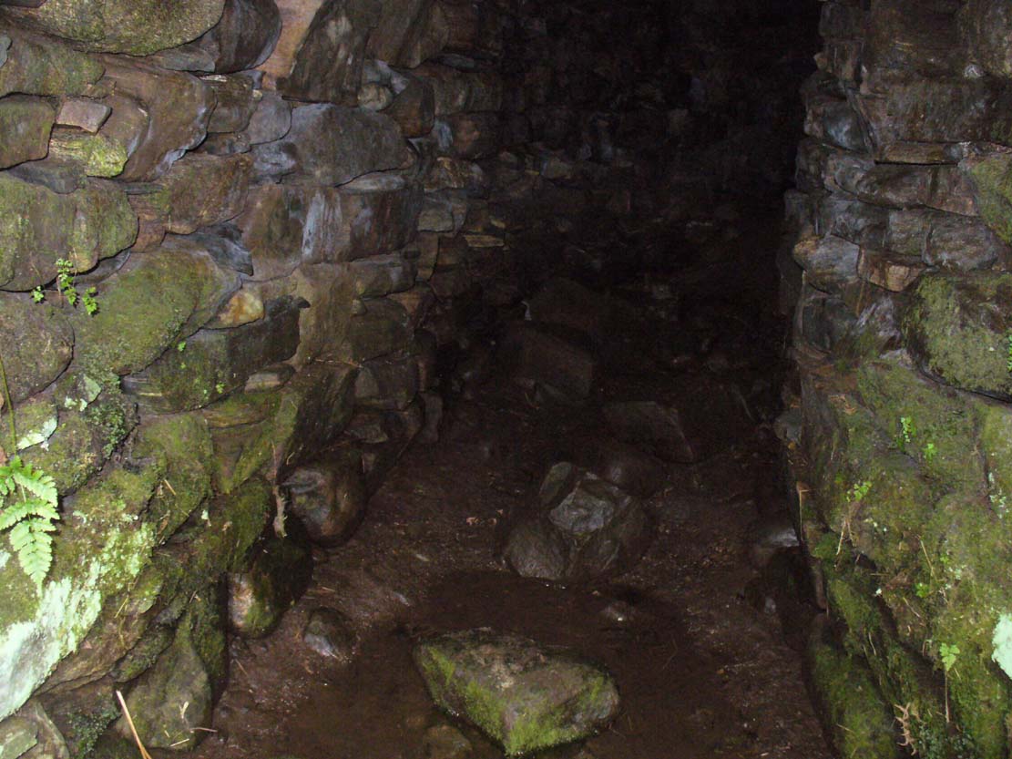
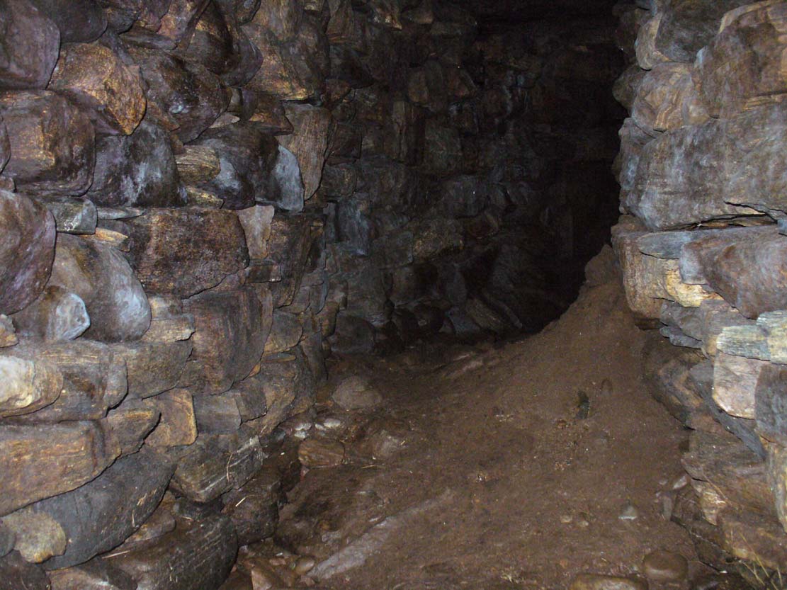
Entrance to an underworldLooking out from inside
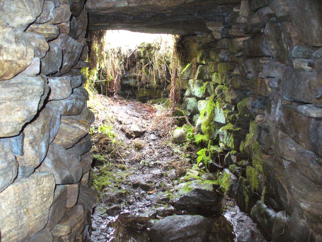
Immediately beneath the ridge where the Borgie chambered cairn once stood, the site was uncovered quite by accident when a local man went to move a large stone on the grassy embankment, to make use of it in walling or something similar. But much to his surprise, the boulder covered the entrance to an underground chamber known as a souterrain – inside which, local lore tends to tell, the little people once stayed. It’s an impressive structure! When Donna Murray took me to see this a few months ago, she said it was only a few yards long – but once I’d got inside, found it to be much longer than this. After dropping perhaps six feet down into the hollow, the very well-preserved wide chamber beneath – some 6-8 feet across – curved around to the north-northeast and into pitch blackness. I walked perhaps ten yards into the chamber, completely upright, and as the chamber curved and went further into the Earth, the pitch black stopped me venturing more.
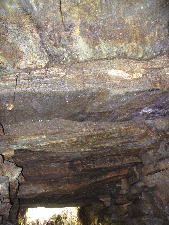
Looking into the darknessLine of roofing stones
The walls of the souterrain were very well structured indeed and were made up of hundreds of good-sized stones, akin to those used to build old stone walling in our northern hills. The floor was, typically, muddy and apart from a scatter of a few stones I could see little by way of a ‘floor’ beneath my feet (but it was dark!). However, the roofing was made up of large flat stones measuring 6-8 feet across, as wide as the structure itself, running parallel all along the chamber. I did not walk to the end of the chamber – but would assume that this roofing continued to the end of the souterrain.
In a number of souterrains we find examples of cup-and-ring carvings (the one at Pitcur, Perthshire, being one of the very best), but I could discern no such petroglyphs inside this chamber. However, considering how dark it was, another investigation with torches is necessary before any definitive remarks regarding internal petroglyphs can be made.
Curving into the darkness
It’s in damn good condition indeed and is well worth looking at if you venture this far north. Other unrecorded prehistoric monuments are found all over this remote landscape – from cup-and-rings, to stone circles, to tombs, enclosures, cairns, you name it! If anyone knows of any permanent rental properties up here – please let me know and get in touch so that I can spend the rest of my life working here meandering, discovering and recording the prehistory of this truly archaic landscape! I’m serious!
Acknowledgements: Immense thanks to Donna from Borgie, for showing me this ancient monument and other sites.
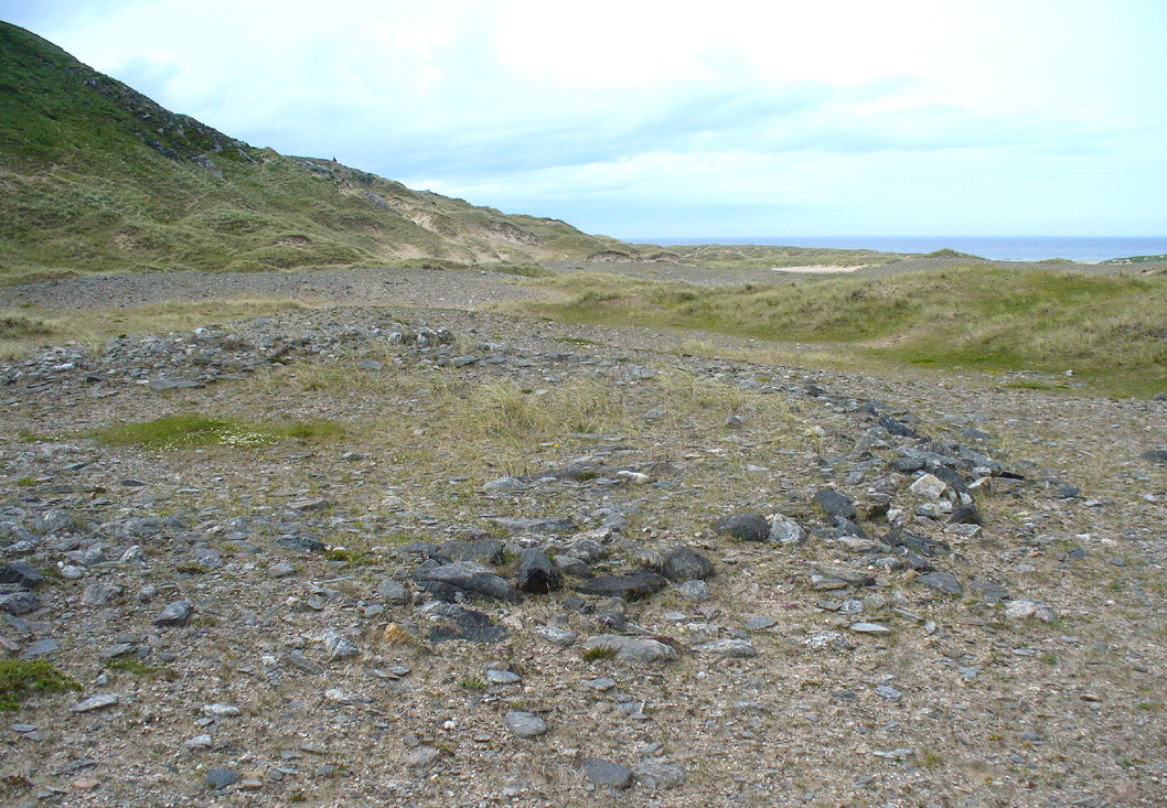
Take the A836 road west out of Bettyhill, down the road and cross the river on the tiny bridge. From here, go over the gate on the right-hand side of the road and follow the edge of the river towards the sea. Crossing the large extensive sands, you’ll reach a large sand and gravel rise ahead of you. Once on top of this natural feature, walk NNE for 550 yards (0.5km) until you reach one of many extensive sandy expanses in the grasses (and pass tons of archaeological remains as you walk!). You’ll get there!
Archaeology & History
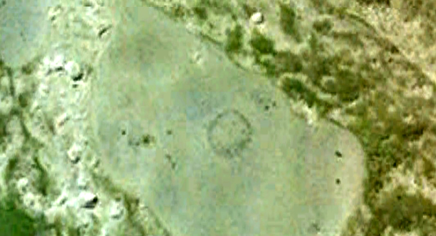
Arc of south, west & north walling
On this naturally raised sand-and-gravel platform at the edge of this beautiful sandy coastline in the far north of Scotland, walking in search of this particular enclosure, you’ll meander past a whole host of prehistoric sites and remains – some of which are plain to see, others hiding almost just above ground level, barely visible. But if you’re an antiquarian or historian, this plateau is a minefield of forgotten history!
The site is shown on the 1878 Ordnance Survey map of the region as a “hut circle”, which it may well have been—but this is a large hut circle and was more probably a place where a large family would easily have lived. When I visited the place the other week, there were no internal features visible. It is a large ring of stones made up of thousands of small rocks whose walls are low and scattered, barely a foot above present ground-level in places, and barely two-feet at the very highest. It has been greatly ruined or robbed of other architectural elements and an excavation is in order. My initial evaluation is that this structure is at least Iron Age in origin. In Angus Mackay’s (1906) venture here in the early 1900s, he suggested that this and the other “circular rings” were “cattle folds.”
Aerial view, looking straight down
Looking down from the broch above
The enclosure measures, from outer-edge to outer-edge of the walling, 16.5 yards (15.1m) east-west by 18 yards (16.5m) north-south, and has a circumference of roughly 52.5 yards (4mm); although an accurate measure of its circumference is hampered by the scatter of spoilage from the collapsed walls stretching outwards. Only the western walled section remains in reasonably good condition.
Looking south, thru the enclosure
Close by are many cairns, some of which are prehistoric. A chambered cairn on the same ridge less than 200 yards away, with another enclosure of the same type yards away, clearly shows that people have lived and used this raised section of land for thousands of years. We know that people were still living here at the end of the 18th century which—for me at least—begs the question: what ancient traditions, customs and lore did these people know about, which may have dated back into truly ancient history? …And then the english Clearances destroyed them…
Royal Commission on Ancient & Historical Monuments, Scotland, Second report and inventory of monuments and constructions in the county of Sutherland. HMSO: Edinburgh 1911.
Get yourself to the Baile Mhargaite Enclosure 1 and walk less than 150 yards southeast. Keep your eyes keenly peeled on the ground as you can easily miss this one!
Archaeology & History
One of Baile Mhargaite’s cists
The only archaeological note I can find of this small singular prehistoric grave is in the Canmore entry, which is far from clear as to the position and situation of many sites hereby. They described this small sand-filled grave (which they describe as ‘Cist b’) as being “on a gravel ridge and is oriented N-S. It measures 0.8m by 0.6m.” That’s it!
Looking down on the tomb
But saying that, it is a small single little thing amidst a huge mass of material. It may well have been covered by a larger cairn at an earlier date, as there are many such monuments on this elevated sandy plain and the slight surround of smaller stones at, and just beneath the surface may validate this. It is also possible that this was the spot where “beaker fragments…found in a cist at Bettyhill” came from, but the archaeological records (Abercromby 1912; Mitchell 1934) are not accurate. Two other cists close by are the other potential candidates!
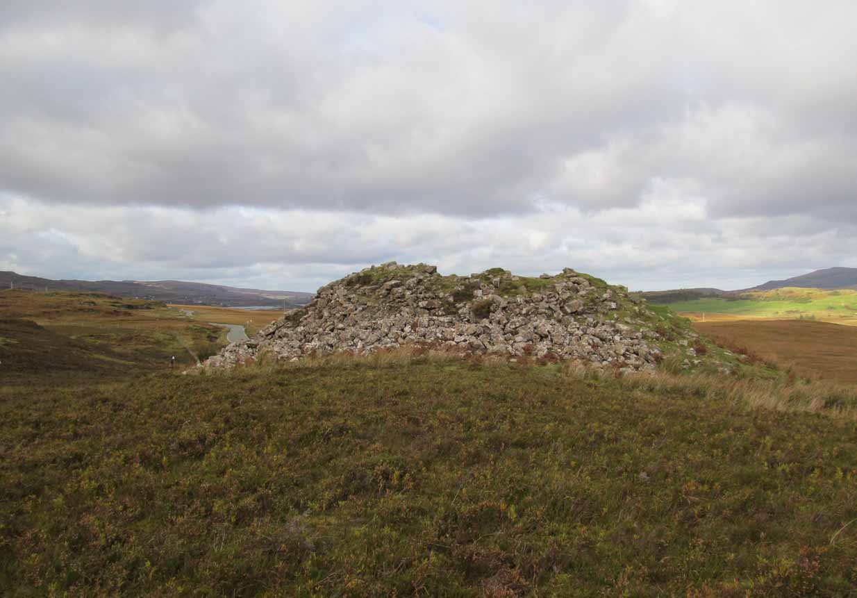
Take the A836 road west through Bettyhill and downhill, turning right and going over the small bridge at the bottom. From here, go over the gate on the right-hand side of the road and follow the edge of the river towards the sea. Crossing the large extensive sands, you’ll reach a large rise ahead of you and, to the left (west) a burn tumbles down from the hills above. Walk up it and head to the rocky rise on the level 50 yards past the burn. You’re here!
Archaeology & History
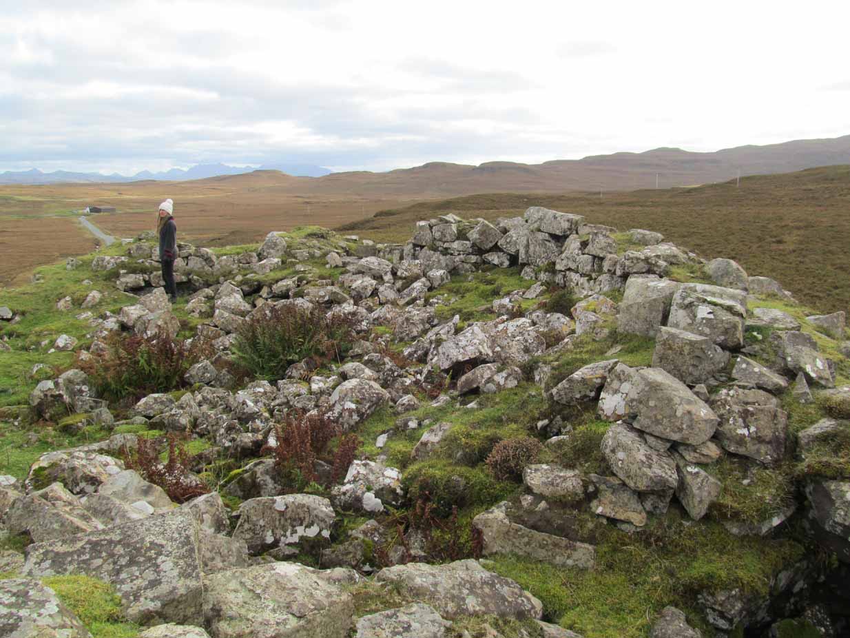
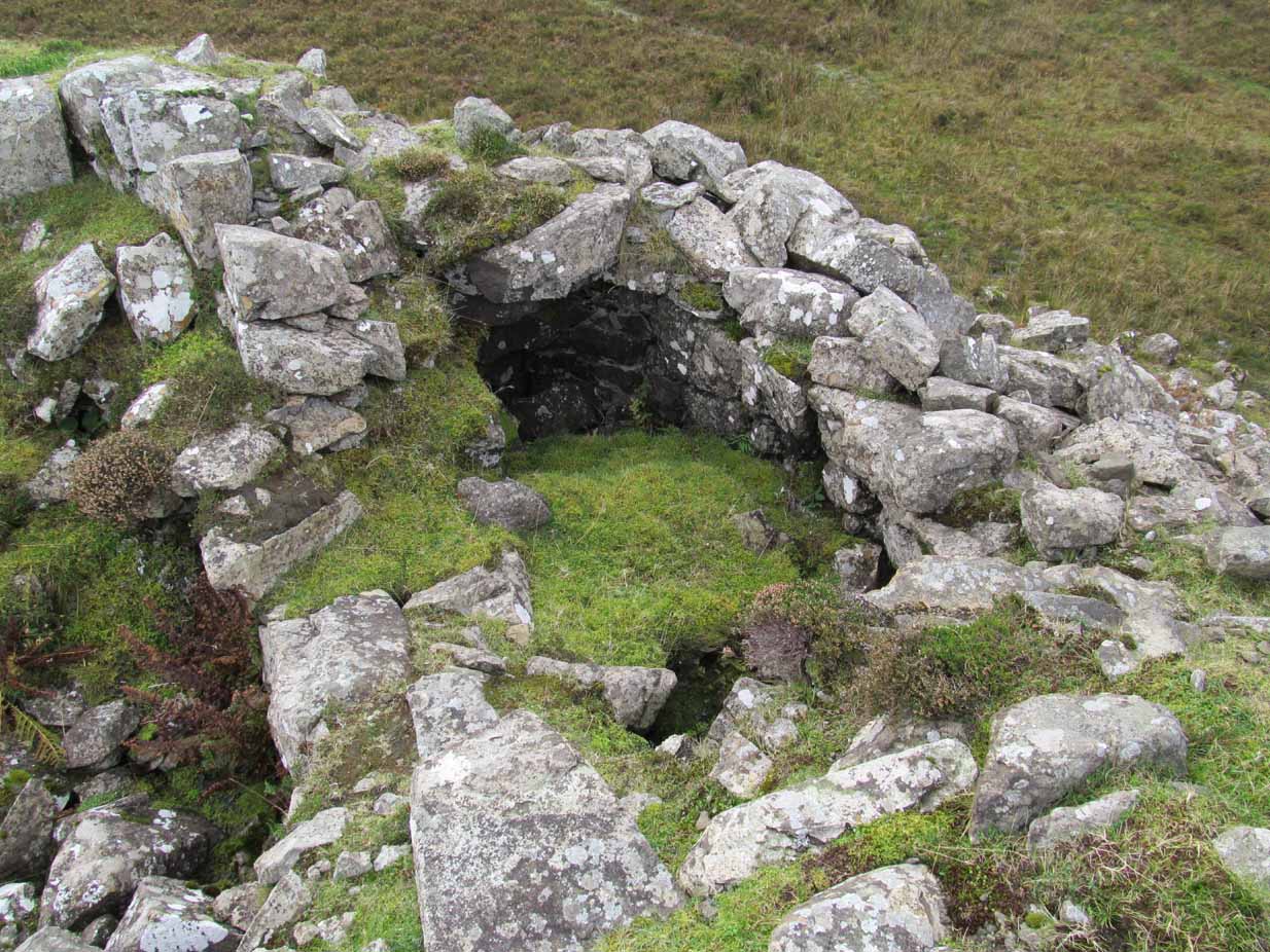
Once you’ve clambered the rocky hill to reach the broch, you’ll be damn impressed. This is a real beauty – although from the outside it looks nothing of the sort. The outer wall is a veritable jumbled mass of rocks piled on top of each other in a manner that looks as if human hands once fumbled them in some sort of order, long since fallen away. Around the western side of the structure, faint remains of steps lead up towards more ordered-looking walling ahead of you. Before you walk up the remains of steps, notice the more structured walling, about three feet high to your right, curving around the large structure you are already inside the edges of.
Whether you walk up the stepped remains or simply up the outer walling, once you see the internal stone walling of this high cliff broch, you’ll be impressed. It’s a big bugger – and in damn good condition when you consider that it’s probably 2000 years old, or more! A large round walled structure, about three feet high all round, well sheltered from the wind and rains, measures some 30 feet across.Arc of outer western wall
The internal living quarters
Eastern section of the broch
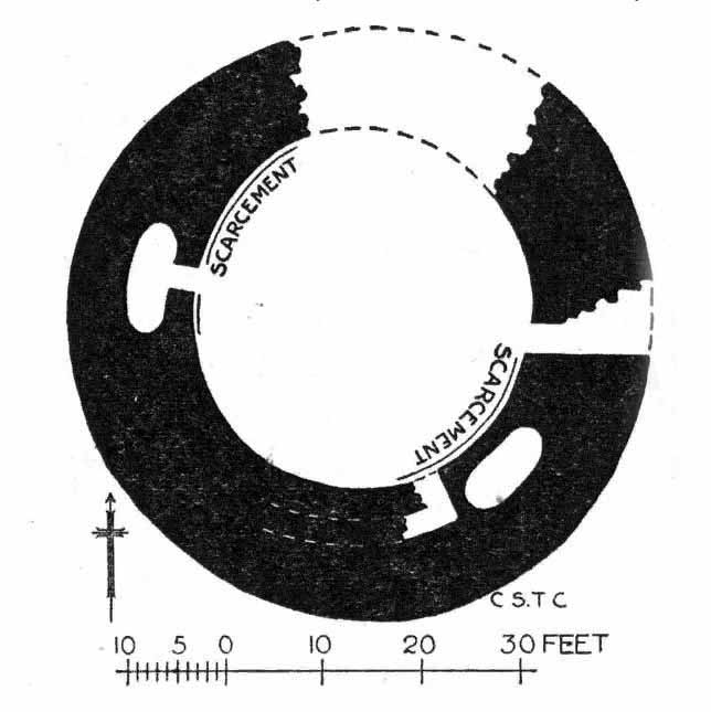
The site is still known by some local people as a “Pictish Tower” and was described as such on the 1878 Ordnance Survey map (see above) and its Gaelic name is Ca an Duin(Mackay 1906). The probability of the brochs as being Pictish in origin is more than likely. Tradition up here speaks of them as such – and we know that such traditions go back many centuries in these isolated areas. An early mention of this Pictish Tower was given in James Horsburgh’s (1870) essay, but it wasn’t described in any real detail until the Royal Commission (1911) fellas looked at the site. They wrote:
“On the summit of the hill which rises to the W of the gravelly plateau opposite Bettyhill, and on the N side of the track which leads from Strathnaver to Torrisdail, is situated a broch. It is called the “Sandy Dun”. The wall is probably erect for a considerable height, but the interior is largely filled up with blown sand. The entrance is from the SW. The interior diameter is 29 feet and the thickness of the wall 12 feet. Near the top of the wall in the interior is a projecting ledge, about 10 feet wide, running all around. The slabs which form it are an integral part of the structure and the wall is thicker below than above. The outer face of the wall is much ruined…”
Gazing NE from inside the broch
Although some of the internal walling has been taken away since the 1911 survey, the interior of the site has been cleaned up by local people and it is presently in a very good condition indeed. The broch may have been built onto an earlier fortified structure, rising above the stunning prehistoric settlements and necropolis on the sandy plateau immediately below. It would make sense – as many earlier Neolithic and Bronze Age remains look up at the prominent rock pinnacle it’s built upon from the sandy plain below, almost as if it was a natural temple in the animistic traditions of the earlier peoples.
If you visit this gorgeous region, the Baile Mhargaite broch should definitely be on your list of sites to see.
Folklore
Old lore told that this broch was attacked by outside invaders many centuries ago. Mr Horsburgh (1870) told that,
“an old woman hid a croc of gold previous to the dun being attacked, and measured the distance from it with a clew of thread.”
MacKie, E W., The Roundhouses, Brochs and Wheelhouses of Atlantic Scotland c.700 BC-AD 500 – volume 2, British Archaeological Report: Oxford 2007.
o’ Reilly, Kevin & Crockfird, Ashley, What to See Around Bettyhill, privately printed 2009.
Royal Commission on Ancient & Historical Monuments, Scotland, Second report and inventory of monuments and constructions in the county of Sutherland. HMSO: Edinburgh 1911.
Acknowledgements: Immense thanks go to Aisha Domleo and Unabel Gordon for their help getting me up here. This site profile would not exist without their encouragement.