Broch: OS Grid Reference – NC 69742 60973
Also Known as:
- Ca an Duin
- Canmore ID 5786
- Invernaver
- Lochan Druim An Duin
- Sandy Dun
Take the A836 road west through Bettyhill and downhill, turning right and going over the small bridge at the bottom. From here, go over the gate on the right-hand side of the road and follow the edge of the river towards the sea. Crossing the large extensive sands, you’ll reach a large rise ahead of you and, to the left (west) a burn tumbles down from the hills above. Walk up it and head to the rocky rise on the level 50 yards past the burn. You’re here!
Archaeology & History
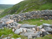
Once you’ve clambered the rocky hill to reach the broch, you’ll be damn impressed. This is a real beauty – although from the outside it looks nothing of the sort. The outer wall is a veritable jumbled mass of rocks piled on top of each other in a manner that looks as if human hands once fumbled them in some sort of order, long since fallen away. Around the western side of the structure, faint remains of steps lead up towards more ordered-looking walling ahead of you. Before you walk up the remains of steps, notice the more structured walling, about three feet high to your right, curving around the large structure you are already inside the edges of.
Whether you walk up the stepped remains or simply up the outer walling, once you see the internal stone walling of this high cliff broch, you’ll be impressed. It’s a big bugger – and in damn good condition when you consider that it’s probably 2000 years old, or more! A large round walled structure, about three feet high all round, well sheltered from the wind and rains, measures some 30 feet across.Arc of outer western wall
The site is still known by some local people as a “Pictish Tower” and was described as such on the 1878 Ordnance Survey map (see above) and its Gaelic name is Ca an Duin(Mackay 1906). The probability of the brochs as being Pictish in origin is more than likely. Tradition up here speaks of them as such – and we know that such traditions go back many centuries in these isolated areas. An early mention of this Pictish Tower was given in James Horsburgh’s (1870) essay, but it wasn’t described in any real detail until the Royal Commission (1911) fellas looked at the site. They wrote:
“On the summit of the hill which rises to the W of the gravelly plateau opposite Bettyhill, and on the N side of the track which leads from Strathnaver to Torrisdail, is situated a broch. It is called the “Sandy Dun”. The wall is probably erect for a considerable height, but the interior is largely filled up with blown sand. The entrance is from the SW. The interior diameter is 29 feet and the thickness of the wall 12 feet. Near the top of the wall in the interior is a projecting ledge, about 10 feet wide, running all around. The slabs which form it are an integral part of the structure and the wall is thicker below than above. The outer face of the wall is much ruined…”
Although some of the internal walling has been taken away since the 1911 survey, the interior of the site has been cleaned up by local people and it is presently in a very good condition indeed. The broch may have been built onto an earlier fortified structure, rising above the stunning prehistoric settlements and necropolis on the sandy plateau immediately below. It would make sense – as many earlier Neolithic and Bronze Age remains look up at the prominent rock pinnacle it’s built upon from the sandy plain below, almost as if it was a natural temple in the animistic traditions of the earlier peoples.
If you visit this gorgeous region, the Baile Mhargaite broch should definitely be on your list of sites to see.
Folklore
Old lore told that this broch was attacked by outside invaders many centuries ago. Mr Horsburgh (1870) told that,
“an old woman hid a croc of gold previous to the dun being attacked, and measured the distance from it with a clew of thread.”
References:
- Horsburgh, James, “Notes of Cromlechs, Duns, Hut-circles, Chambered Cairns and other Remains, in the County of Sutherland“, in Proceedings Society of Antiquaries, Scotland, volume 7, 1870.
- Mackay, Angus, “Notes on a Slab with Incised Crescentic Design, Stone Mould for Casting Bronze Spear-Heads, a Cup-Marked Stone, Holy Water Stoup, and other Antiquities in Strathnaver, Sutherlandshire,” in Proceedings of the Society Antiquaries, Scotland, volume 40, 1906.
- MacKie, E W., The Roundhouses, Brochs and Wheelhouses of Atlantic Scotland c.700 BC-AD 500 – volume 2, British Archaeological Report: Oxford 2007.
- o’ Reilly, Kevin & Crockfird, Ashley, What to See Around Bettyhill, privately printed 2009.
- Royal Commission on Ancient & Historical Monuments, Scotland, Second report and inventory of monuments and constructions in the county of Sutherland. HMSO: Edinburgh 1911.
Acknowledgements: Immense thanks go to Aisha Domleo and Unabel Gordon for their help getting me up here. This site profile would not exist without their encouragement.
© Paul Bennett, The Northern Antiquarian


