From Blubberhouses church by the crossroads, walk up the slope (south) as if you’re going to Askwith, for 100 yards or so, taking the track and footpath past the Manor House and onto the moor. Once you hit the moorland proper, take the footpath that bears left going down into heather and keep going till you hit the dead straight Roman Road path running west onto Blubberhouses Moor. Go on here for nearly a mile until you hit the stream and nearby Eagle Stone boulder. Walk upstream from here, on its eastern (right-hand) side for 100 yards, then walk up onto the level moor, scattered with rushes. Keep up here, heading towards the upright cairn open the skyline to the north. Once here, walk 80 yards (73m) WNW and you’ll note a number of flat stones embedded in the heather around you. You’re damn close!
Archaeology & History
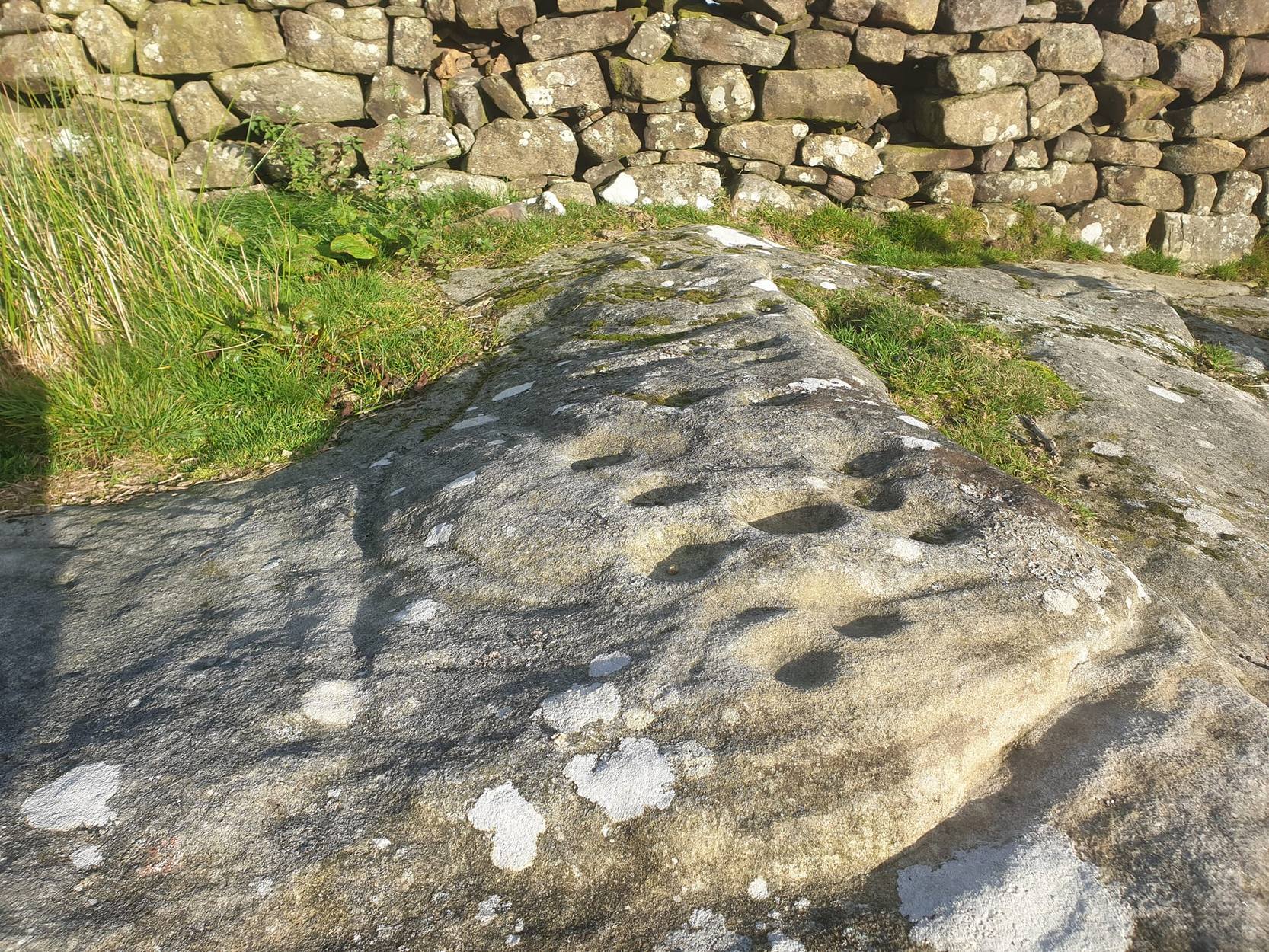
Off-path and takes some finding and will all-but disappear when the heather grows back, so this one’s probably only for the purists amongst you. But I like it anyway! This is one of at least seven newly-discovered cup-marked stones hereby, including the nearby ‘Owl Stone’ with it’s big eyes! There are just two cup-marks on the flat surface: one an archetypal large cup 3 inches across and a half-inch deep; the other, a small faint cup less than 2 inches wide and very shallow which is easily missed if you pay little attention. On the photo here, the fainter cup is slightly above right of the centre. The carving appears to be on the far eastern edges of the Slade Cairnfield. Other undiscovered remains are likely to be found here.
From Appletreewick take the road east through Skyreholme and up Skyreholme Bank, bearing right at the fork in the tracks along the ancient Forest Road. Keep going till you cross the Larnshaw Beck and keep walking along the track until it runs wallside. Look over the wall and you’ll see this sloping-chair-shaped rock . You’re here!
Cup-Marked stone 431
Archaeology & History
Worth looking at if you’re visiting the Spiral Stone of Eller Edge field and its large associate, but otherwise this cup-marked stone is probably only for the purist rock-art mad-folk amongst us! There are what seem to be three decent cup-marks upon the sloping face of the rock here, with a possible pecked line to the side of two of them — though we have to consider the possibility that a geological condition is responsible for the easternmost cup. Described in the Boughey & Vickerman (2003) survey simply as:
“Large triangular rock of smooth gritstone, quarried at SE and sloping into ground at W and N. Three cups on top sloping face.”
Thirty yards up the slope along the wall-side you’ll find carving 432 with its single cup-marking.
References:
Boughey, Keith & Vickerman, E.A., Prehistoric Rock Art of the West Riding, WYAS: Wakefield 2003.
A slight walk to get here, but well worth it once you arrive! From Appletreewick, take the road east through Skyreholme and up Skyreholme Bank track, bearing right at the fork in the tracks along the ancient Forest Road. Keep going and after a couple of zigzags, you’ll cross the Larnshaw Beck. Keep walking along the track until it runs wallside — and here, go straight down the field for 75 yards (best climbing over the rickety wooden bridge by the stream 50 yards back and walking up). Although there are a number of other stones hereby, you can’t really miss this.
Archaeology & History
This carved stone and its close associates rest upon the green slopes overlooking the Blands Valley and further across upper Wharfedale and the lands beyond. The majestic Simon’s Seat rises on the nearby western slope and there in the greater distance, once more reaches the sacred hill of Pendle, with whom so many other ancient sites commune within our northern lands. It’s hard to say for sure that the Witch’s Hill was of little relevance to this and other stones, but only a fool would ignore the geomancer’s notes about this constant.
The carving here doesn’t give much clues in any direct sense either. We have an almost arrowhead-shaped rock with a dozen decent cup-marks or so cut along and near its western side; but the notable curiosity here is the small circular cluster of smaller cup-marks dotted in a near circular mass near the middle of the stone.
When Danny, Paul and I came here the other week, the initial impression of this cluster was one of a primitive solar symbol etched onto the rock; but the more we looked, the more it seemed that these small cups appeared to have been arranged in a very rough spiral lay-out. Now I know that spirals are damn rare items in rock art (especially in this part of the world), but the more we looked and then subsequently checked Boughey & Vickerman’s (2003) illustration, the more evident it became. Of course the ‘spiral’ could be merely fortuitous, but I’m not so sure misself. In discussing this with our field archaeologist later, he suggested getting a rubbing of this part of the stone on his next visit.
The stone was first described by the petroglyph explorer Stuart Feather (1964) and later described by the rock art students Boughey & Vickerman (2004), simply as:
“Large, rough grit rock with face sloping SE down into grass at N. About twenty cups to W, with three grooves at N corner and group of about twenty small cups at NE.”
A very intriguing carving. And if you visit here, make sure you check out carving 424 and others in the same field.
References:
Boughey, Keith & Vickerman, E.A., Prehistoric Rock Art of the West Riding, WYAS: Wakefield 2003.
Probably the easiest way is to park up at Stump Cross Caverns on the B6265 road, then walk down the road for 200 yards till you reach the track on your left running over the fields in the direction towards Simon’s Seat. Walk along the track past the Skyreholme Wall carving, where it starts going downhill and, 100 yards before you reach the fork in the tracks, look in the field on your left. The other route is to go east through Appletreewick village up to and through Skyreholme as far as you can drive, where the dirt-track begins. Keep going up till you hit the fork in the tracks. Go left, then thru the first gate you come to and walk up into the second field up where the notable rock stands out. If you can’t see it at first, look around!
Archaeology & History
Boughey & Vickerman’s plan of the carving
This carving was rediscovered by Stuart Feather (1964) in one of his ambles in the area — and he would have been pretty pleased when he found this one! It is the most complex and ornate of all the prehistoric carvings in and around this large open field. With at least nine cup-and-rings and more than fifty other cups etched onto its rounded upper surface, there are various other lines and grooves linking up some elements of this mythic design. The best ones are on the upright and sloping east-face of the rock, into the rising sun. In animistic terms the rock is distinctly female in nature.
Illustrated in one of Stan Beckensall’s (1999) works, the rock art students Boughey & Vickerman (2003) also include it in their survey, but give an inaccurate grid reference for the site. They nevertheless describe it as:
“Large upstanding rock with slightly domed top surface. Most of top surface decorated but weathering makes detail uncertain: over sixty cups, eight or more with rings, many grooves.”
Many other carvings can be found in the area.
References:
Beckensall, Stan, British Prehistoric Rock Art, Tempus: Stroud 1999.
Boughey, Keith & Vickerman, E.A., Prehistoric Rock Art of the West Riding, WYAS: Wakefield 2003.
Morris, Ronald W.B., “The Prehistoric Rock Art of Great Britain: A Survey of All Sites Bearing Motifs more Complex than Simple Cup-marks,” in Proceedings of the Prehistoric Society, volume 55, 1989.
Acknowledgements: Huge thanks to the pseudonymous ‘QDanT‘ for use of the photo in this profile. Cheers Danny!
One way is to go east through Appletreewick village up to and through Skyreholme (making sure you bear right at the turn and not go up the left turn, which takes you uphill and elsewhere!) as far as you can drive, where the dirt-track begins. Keep going up till you hit the fork in the tracks, and here, look into the field on your right. The other way is to park up at Stump Cross Caverns on the B6265 road, then walk down the road for 200 yards till you reach the track on your left running towards Simon’s Seat. Walk all the way down this till you reach the fork in the tracks. There’s a gate into the field just yards below the split in the tracks. Go thru it and walk into the middle of the field where the stone unmistakably calls out for you to go sit with it for a while!
Archaeology & History
Boughey & Vickerman’s plan of the cup-marks
Sat near a ridge due north of the magnificent Simon’s Seat, this faded carved stone gets its name from the field in which it lives — and as Danny’s photo here shows, it’s a fine stone indeed in a very fine setting. The cup-marks on its top were first described by Stuart Feather (1964), who found there to be around 20 cup-markings on the top, with some grooves — possibly natural, possibly man-made — linking them together.
However, in the fields north of here are a number of other cup-and-ring carvings, but much of the landscape has been damaged by industrial workings. It makes you wonder how many there used to be here before the industrialists started digging the land up…
References:
Boughey, Keith & Vickerman, E.A., Prehistoric Rock Art of the West Riding, WYAS: Wakefield 2003.
Morris, Ronald W.B., “The Prehistoric Rock Art of Great Britain: A Survey of All Sites Bearing Motifs more Complex than Simple Cup-Marks,” in Proceedings of the Prehistoric Society, volume 55, 1989.
Acknowledgements:
Huge thanks to the pseudonymous ‘QDanT‘ for use of the photo in this profile. Cheers Danny!
Corrycharmaig 3 stone, with Meall Dhuin Croisg rising…
Go thru Killin and, just past the Bridge of Lochay hotel, take the tiny road on your left. Go down here for 3 miles till you pass the gorgeous Stag Cottage (with its superb cup-and-rings in the field across the road) for another 300 yards, until you see Duncroisk Farmhouse set back on your right. On the other side of the road, go thru the giant deer-gates (close ’em behind you) to the river-bridge and across it. Walk along the track till you reach the turning to Corrycharmaig House on the right (over the stream), but here, go up into the field thru the gate. Walk up the hill ahead of you with its trees on the left, walking up onto the grassy level, then up again to the rounded knoll another 100 yards up. You’re here!
Archaeology & History
This is the most visually impressive of the set of four cup-marked rocks along this ridge — although if you visit here when the light is poor, or the sky’s overcast, you’ll be lucky if you can actually see much of the material. For example, I counted 38 cups on this particular stone on a day when the sky was bright, but upon checking later, found that Mr Morris (1981) described there being, “40 widely scattered cups of which, however, 29 well-defined cups are in a compact group of which 6 are in line.” Whereas more recently the Canmore website told there to be,
Corrycharmaig-3 carvingClose-up of line of cups
“At least 48 cupmarks are visible on the most westerly exposure. The cupmarks range in size from 25mm in diameter and 5mm in depth to 100mm in diameter and 40mm in depth. A straight line of six cupmarks arranged close together is orientated running from NW to SE.”
This line of six cups is very distinct and stands out as the most notable aspect on this carving, probably because it gives a sense of ‘order’ or linearity, whereas the rest of the carving (as with oh so many of them, thankfully) possess that non-linear feature of scattered cups and lines, dissolving reason and ego, and eliciting the natural meditative state, if one so cares to allow. On our most recent visit here, our eyes and fingers traced what appeared to be the faint remains of a carved line running along the bottom edge of the row of cups and then bending around the bottom cup in the same line — a little bit like the carved lines which run around the edges of the row of cups on Ilkley Moor’s Idol Stone. You can just make this ‘line’ out in the photo, below.
Cup-mark and flintClusters of cups and faint line
On one visit to the site when we’d stayed with the late great Lindsay Campbell of Stag Cottage, other sections of this carving were visible that we’d previously missed, highlighting at least 45 cup-marks that we counted. Several of the cups had been exposed by animals (sheep or deer – we couldn’t tell) cutting into the soaking wet earth and in carefully checking a couple of cups whose edges were exposed, found a small worked flint within one of the cups! I looked at it, held it, puzzled over it, then laid it back where we’d found it. You can see it in the photo here, on the right.
This carving obviously grows on you with time. And like its carved companions of Corrycharmaig (1), (2) and (4) both left and right of here, the stone rests within a natural theatre of dreams, eliciting — if only in a slight way — the non-focal perspective necessary to receive the carvings as its executor knew…
Morris, Ronald W.B., The Prehistoric Rock Art of Southern Scotland, BAR 86: Oxford 1981.
Royal Commission on the Ancient & Historical Monuments of Scotland, Archaeological Sites and Monuments of Stirling District, Central Region, Society of Antiquaries of Scotland 1979.
An intriguing and little-known carved stone whose existence has been brought to our attention by historian and author John Dixon. Its precise history and nature seems unknown; but aspects of the carving possess symbols that are found on early christian remains, as well as some cup-and-ring designs. John wrote:
Artist’s impressionFoulscales Stone
“This enigmatic stone (27 inches height, 12 inches wide, 6 inch thickness), anciently known as the Yolstone and later as the Bonstone, once stood behind Foulscales Farm, near Gibbs. For some reason the stone was removed from this site and taken into the cellars of Knowlmere Manor under the authority of the Peel Estate.
The stone displays possible early native chi-rho symbols that may have a 6/7th century provenance. The lettering ‘HT’ look to be of 16/17th century origin and may refer to the Towneley family who held lands in Bowland.”
Was it a boundary stone? A gravestone? Was it an early christian stone? A Romano-British stone? The carved circles with ‘crosses’ inside them are typical Romano-British period designs, covered extensively in the early works of J. Romilly Allen and found to be widespread across Britain. Any further information on this stone would be greatly appreciated.
From Masham take the Fearby Road & go through the village, onwards & past Healey village and less than a mile on where the road forks, bear to the right past and go along the gorgeous little-known vale of Colsterdale. Less than 2 miles on, walk up the notable track veering to your right that goes diagonally uphill and past the bottom of West Agra farm along the wallside till you reach the gate. Thru the gate, walk immediately uphill on your right following the walling for a coupla hundred yards until you reach another gate into the field on your right. You’ll see a cluster of large boulders in the first field, which you need to walk past and look at the large boulder up against the walling in the next field. You can’t miss it!
Archaeology & History
Photo by Geoff Watson
First mentioned — albeit briefly — in Brown’s (2008) work, this large bedrock stone, covered down its eastern side by a line of drystone walling, has a good scattering of cups and lines, mainly on its central and westerly side. A cluster of them were etched onto a natural rise near the middle of the rock, which itself has a long circuitous line running around its northern and western sides, which you can just see below centre in the photo (below left). Altogether on this side of the rock surface there appears to be some 56 cup-marks plus a number of long carved grooves curling in differing directions: some of these appear to have been Nature’s handiwork that were subsequently modified by human hands. It’s an impressive-looking petroglyph.
Main rock surfaceCluster of cups – by QDanT
If we go over to the other side of the walling, we find more cup-markings. This discovery led Paul & Barbara Brown (2008) to classify the site as being two separate carved rocks — calling them 3a and 3b — thinking that the much smaller carved area on the other side of the wall, “may have originated from WAP 3a’s quarried southern section.” On this smaller section we find some 7 cup-markings with possible carved lines running off the edge of the stone and some running roughly parallel to the walling. Whatever the truth of the Browns’ assertion, this is a fine carving well worth looking at!
References:
Brown, Paul & Barbara, Prehistoric Rock Art in the Northern Dales, Tempus: Stroud 2008.
From Masham, take the Fearby Road to the village, keep going on the same road through Healey village and less than a mile on where the road forks, bear to the right past and go along the gorgeous little-known vale of Colsterdale. It’s bloody beautiful! Less than 2 miles on, walk up the notable track veering to your right that goes diagonally uphill and past the bottom of West Agra farm along the wallside till you get to the gate. Thru the gate, follow the wall immediately uphill to the right for a coupla hundred yards until you reach a gate into the field on your right. The cluster of large boulders in front of you is where you need to be!
Archaeology & History
Cluster of cups on WAP-2b (image by ‘QDanT’)
This carving is to be found on the largest of the boulders in this cluster. It’s a large scattered cluster of cup-markings and natural bowls all over the rolling surface of the rock. It was first described in the Browns’ (2008) survey, although as they have given this and one of the adjacent stones incorrect grid-references, it made it troublesome to initially work out which carving was which! But the photos here certainly lets you know which one I’m describing! In the event that I’ve got the wrong title for this one, someone lemme know and I’ll remedy the situation!
Brown (2008) describes this design as being “cups some linked by grooves, a rectangular feature and eroded cups and depressions.” We couldn’t work out any further elements on the stone, but the cloudy conditions when we were here prohibited a decent view of the surface.
References:
Brown, Paul & Barbara, Prehistoric Rock Art in the Northern Dales, Tempus: Stroud 2008.
From Masham, take the Fearby Road to the village, keep going on the same road through Healey village and less than a mile on where the road forks, bear to the right past and go along the gorgeous little-known vale of Colsterdale. It’s bloody beautiful! Less than 2 miles on, walk up the notable track veering to your right that goes diagonally uphill and past the bottom of West Agra farm along the wallside till you get to the gate. Thru the gate, follow the wall immediately uphill to the right and, about 100 yards up, watch out for the large flat stone by the side of the footpath. You can’t really miss it.
Archaeology & History
Initially we thought that this carving was one described in Paul Brown’s work as ‘West Agra Plantation no.1’, but this is clearly a different carved stone. It is found close to WAP-1 (as he called it), but a few yard further up alongside the footpath by the walling. With two large bowls on the top of the stone and another at the edge, two average-sized cup-markings are several inches away to the bottom-right of the largest bowl. What seems to be a carved line runs from one of the cups. We need to visit this stone again and look at it when there’s better lighting conditions so we can get a more accurate assessment of its nature.
References:
Brown, Paul & Barbara, Prehistoric Rock Art in the Northern Dales, Tempus: Stroud 2008.