A tricky venture, best approached along the B9113 eastwards out of Forfar, towards Rescobie Loch. Just a coupla hundred yards past the lochside, go up the track that leads you to the farmhouse called West Mains of Turin, below Turin Hill on the left-hand side of the road (north). Go up through and past the farm, up the track until you hit the gate that takes where the old quarries appear. Looking right, a copse of woods appears. Go into it and about two-thirds way up, a slight rise marks a long ridge of rock cutting across the woodland. The carving is near the very eastern end of this ridge at the far side of the trees. Good luck!
Archaeology & History
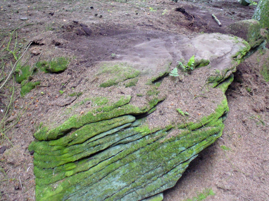
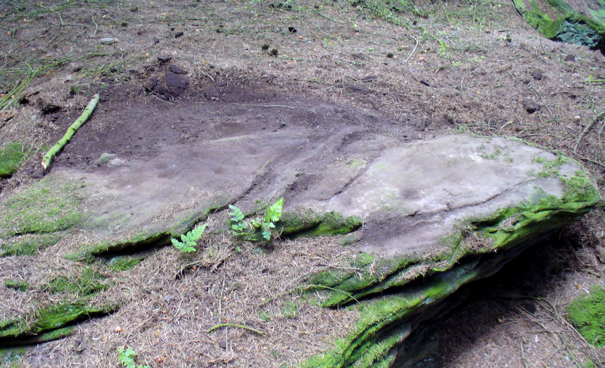
Cup-markings, faintly visible
Not included in John Sherriff’s (1995) survey of Angus petroglyphs, this “carving”, like many in his survey, may be deemed slightly debatable and require the attention of qualified geologists to ascertain the veracity, or otherwise, of a number of supposed cup-marked stones that he describes. This one, found in the woodland beneath the undergrowth of years of pine needles and such things (hence the poor quality photos), has between 9 and 11 cup-markings etched on the southern sides of a large earthfast stone found in the woodland. There may be more cups on this rock, beneath the compressed vegetation, but we didn’t spend too much time here to find out (bad boys that we are!).
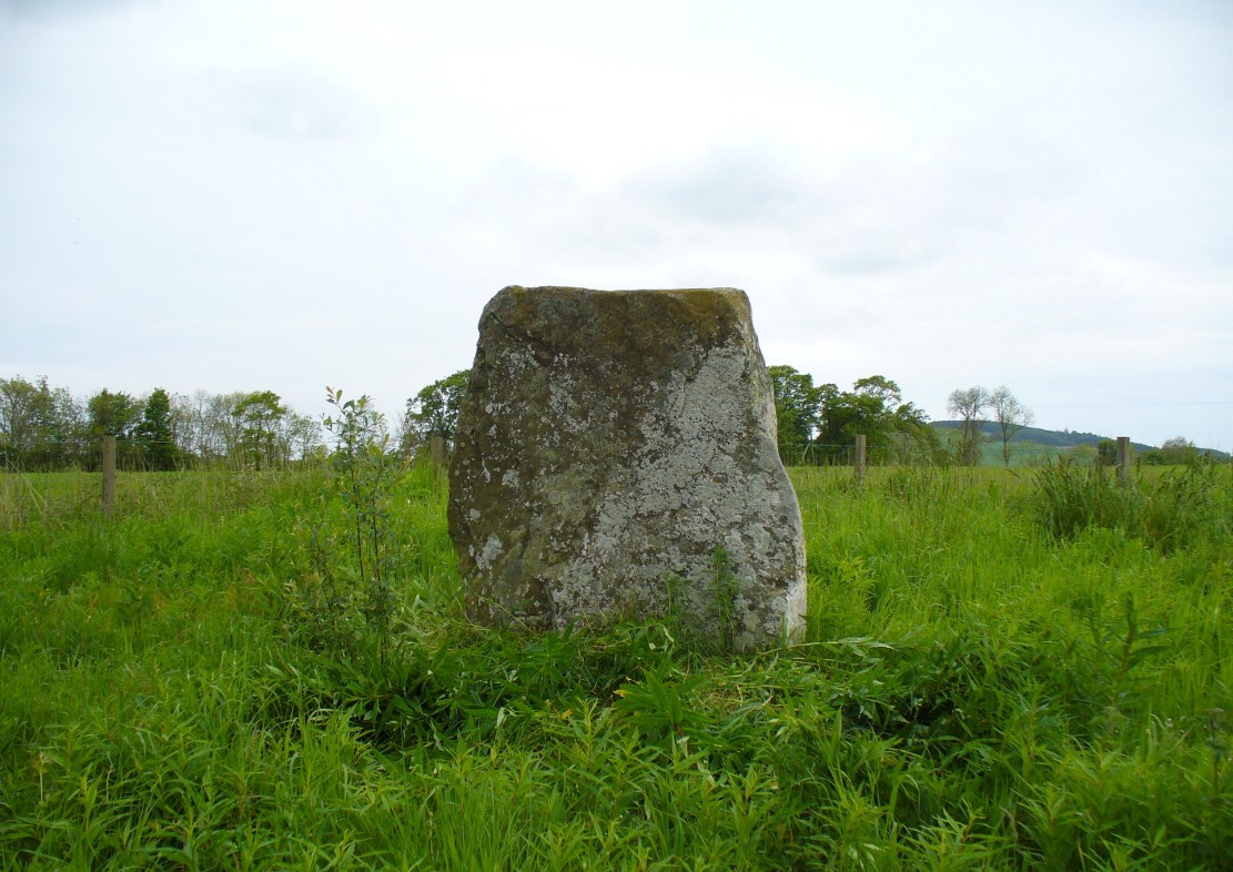
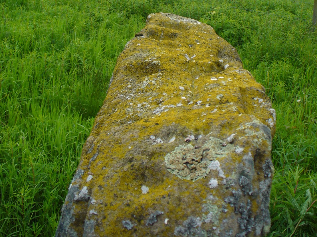
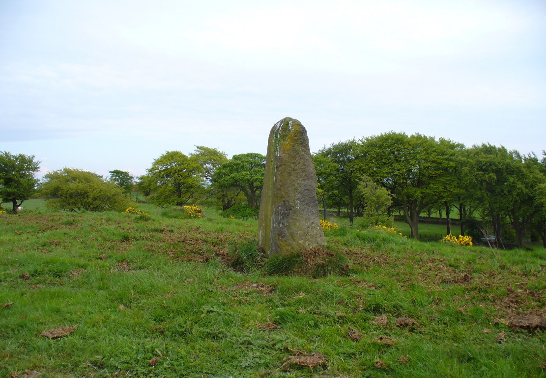
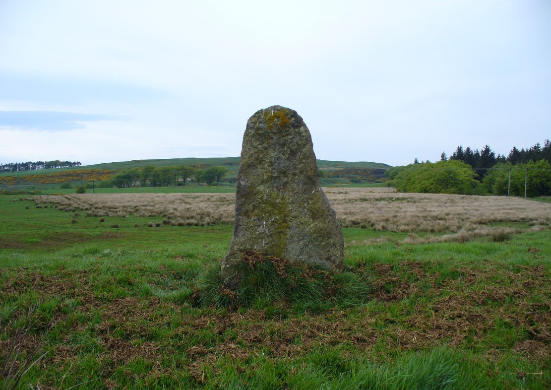
The easiest way to find this is by going along the B9113 road that runs from the east side of Forfar, out to Montreathmont Forest. Along this road, pass the Rescobie Loch and keep going for another mile or so, until you hit the small crossroads. Go left here as if you’re going to Aberlemno. Barely 100 yards up, opposite the newly-built Westerton house, the standing stone is on the rise in the field.
Archaeology & History
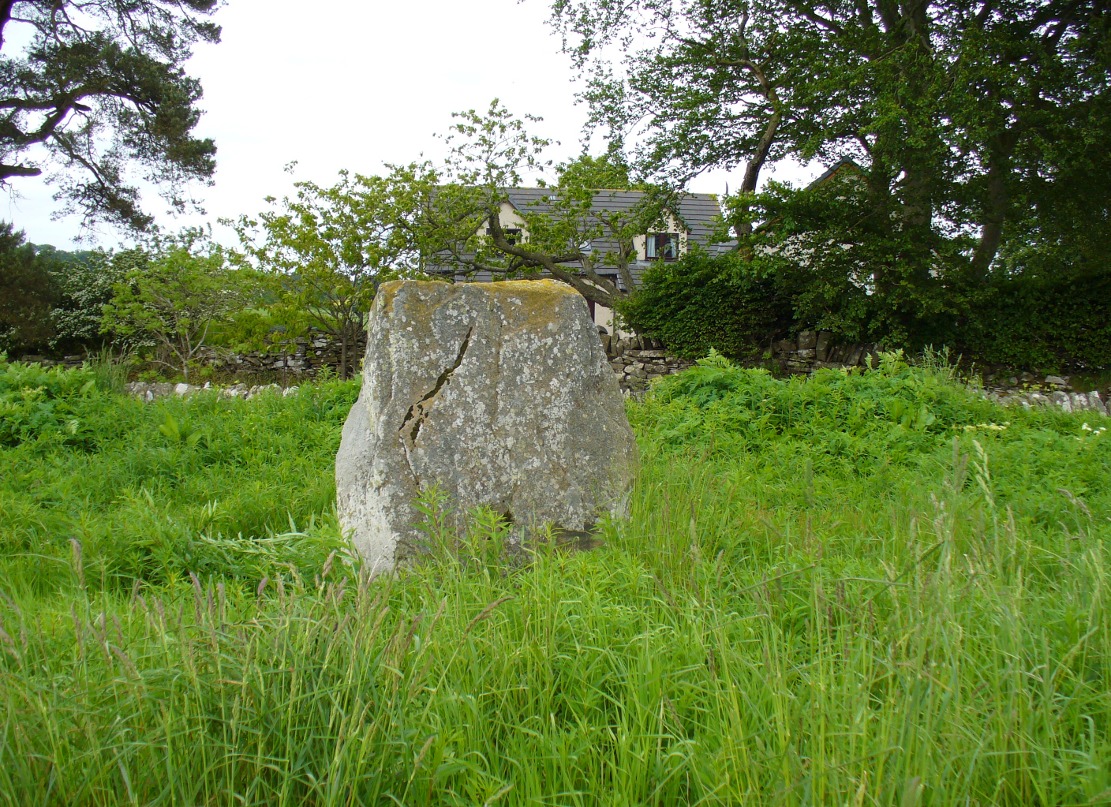
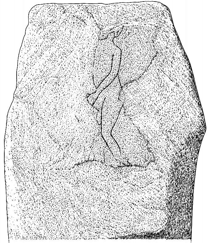
The carved west-facing side
A truly fascinating heathen stone in a parish full of Pictish and early christian remains, with the faint remains of an intriguing carving that can still, thankfully, be discerned on the southwestern face of the upright….amongst other things…
Marked as a singular stone after the Ordnance Survey lads visited here in 1901, early mentions of the site are very scant indeed. In Sir James Simpson’s (1866; 1867) early masterpiece on prehistoric rock art, in which he named the place as the “Circle of Turin,” he related how his friend and associate Dr Wyse told him how this stone “once formed one of a fine circle of boulder stones at Nether Turin,” but said little more. (Simpson was the vice president of the Society of Antiquaries of Scotland, a professor of medicine, as well as being one of Queen Victoria’s chief physicians.) The “Dr Wyse” in question was very probably Thomas Alexander Wise, M.D., who wrote the little-known but informative and extravagent analysis of prehistoric sites and their folklore in Scotland called A History of Paganism in Caledonia (1884). Therein he told us:
“At Turin, in Forfarshire, there is a large boulder which had formed one of the stones in a circle. On the flat top are several cups arranged irregularly, and without any enclosing circles. This boulder stone is on the NW face of the circle. The other side was towards the SE, facing the rising sun.”
As a result of these early references the site is listed and documented, correctly, as a “stone circle” in Aubrey Burl’s (2000) magnum opus. We do not have the information to hand about who was responsible for the circle’s desctruction—but it was likely done by the usual self-righteous industrialists or christians. It is a puzzle therefore, why Barclay & Halliday (1982) sought to reject an earlier “megalithic ring” status as mentioned by Sir James and Dr Wise, with little more than a flippant dismissal in their short note on the Westerton stone. Unless those two writers can offer vital evidence that can prove that the Westerton standing stone was not part of a megalithic ring, we can of course safely dismiss their unsubstantiated claim.
Despite this however, they do give us an intriguing description of a curious carving, faintly visible, of an upright male figure etched onto the west side of this standing stone. The carving has unfortunately been damaged—probably by intruding christians or puritans of some sad form. You’ll see why I’m blaming them in a minute! In their short account of the carving, Barclay & Halliday (1982) state:
“Much of the original surface of the SW face of the stone has scaled off, but, on the surviving portion, there is a part of a human figure…apparently naked, outlined by grooves, measuring between 5mm and 15mm in breadth and up to 7mm in depth. Of the head, only the lower part of the jaw and neck can be identified, and a second groove at the back of the neck probably represents hair or some form of head-covering. The left arm passes across the body into the lap and the arch of the back is shown by a groove which detaches itself from the upper part of the arm. The left leg is bent at the knee and is lost below mid-calf; from mid-calf to jaw is a distance of some 0.85m”
In interpreting this carving the authors make a shallow, if not poor attempt to describe what he may be doing, saying:
“The figure is viewed from its left side and is turned slightly towards the observer. The position of the left arm and leg may be compared with those of a fighting figure depicted on the Shandwick Stone, Easter Ross…but they may also reflect a riding posture; no trace of a mount, however, has survived.”
Damaged carving of a man doing summat with his cock!
Well – that is intriguing. But we have to recognise that our authors work for the Royal Commission, which may have effected their eyes and certainly their minds—as everyone else sees something not drawn out of Rorscharch’s famous psychology test! When I put the drawing you can see here (left) onto various internet archaeology group pages (including the Prehistoric Society, etc) the response was virtually unanimous, with some comical variants on what the carved man is doing — i.e., masturbating, or at least committing some sort of sexual act, possibly with another creature where the rock has been hacked away by the vandals. But a sexual act it is! Although such designs are rare in Britain, they are found in prehistoric rock art and later architectural carvings in most cultures on Earth. The nearest and most extravagant examples of such sexual acts can be found in the Scandinavian countries, where fertility images are profuse, often in tandem with typical prehistoric cup-and-ring designs. (see Coles 2005; Gelling & Davidson 1969, etc)
Line of cup-marks on top of stone
…And, on the very top of the stone, running along its near-horizontal surface, a line of six cup-markings are clearly visible. Intrusions of natural geophysical scars are also there, but the cup-marks are quite distinct from Nature’s wear, all on the west side of the natural cut running along the top. These cup-marks were first mentioned in Simpson’s (1866; 1867) early tome, where he told how his “esteemed friend Dr Wyse discovered ‘several carefully excavated cavities upon its top in groups, without circles.'” Whether these neolithic to Bronze Age elements had any association with the later Pictish-style wanking fella (fertility?) is impossible to know, sadly…
References:
Barclay, G.J. & Halliday, S.P., “A Rock Carving from Westerton, Angus District,” in Proceedings of the Society of Antiquaries, Scotland, volume 112, 1982.
Burl, Aubrey, The Stone Circles of Britain, Ireland and Brittany, Yale University Press 2000.
Coles, John, Shadows of a Northern Past, Oxbow: Oxford 2005.
Gelling, Peter & Davidson, Hilda Ellis, The Chariot of the Sun and other Rites and Symbols of the Northern Bronze Age, J.M. Dent: London 1969.
Sherriff, John R., “Prehistoric Rock Carvings in Angus,” in Tayside & Fife Archaeological Journal, volume 1, 1995.
Simpson, James, Archaic Sculpturings of Cups, Circles, etc., Upon Stones and Rocks in Scotland, England and other Countries, Edmonston & Douglas: Edinburgh 1867.
Wise, Thomas A., History of Paganism in Caledonia, Trubner: London 1884.
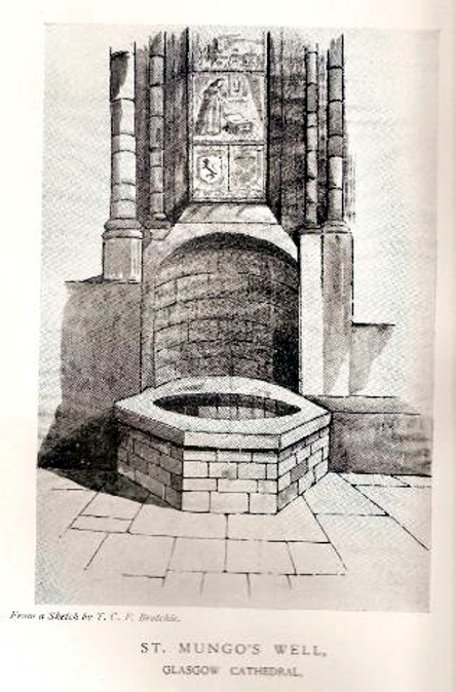
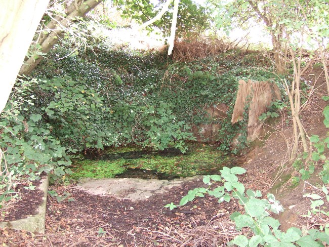
Not to be confused with the sacred well of the same name found along Gallowgate a short distance to the south, the waters of this ancient well have sadly fallen back to Earth. The structure built above it, however, is thankfully still preserved inside the Cathedral, as visitors will see.
Folklore and history accounts tell its dedication to be very early – and the tale behind the erection of the cathedral is closely associated with the waters themselves. Indeed, if the folklore is accepted, we find merely a transference of early animistic ideas about the death of an ancestor placed onto this early Saint, with a simple association in the formula of: tomb, holy site and architectural form. It could almost be Bronze Age in nature!
The lengthiest (and best) description of St Mungo’s Well was by Mr Brotchie (1920) in a lecture he gave on the city’s holy wells in April 1920, which was thankfully transcribed by the local history society. He told us:
“It seems to me that Glasgow in a very particular degree is a case that illustrates emphatically the existence of the early cult of the sacred fountain (sketch attached)… How came it to be there? In itself it represents the very beginning of Glasgow. It was to the little spring on the hillside overlooking the Molendinar that there came the earliest of christian missionaries, Ninian. All that we know of Ninian is from the account of Jocelin, the monk of Furness, who tells us that “ane holy man Ninian cam to Gleschu or Glasgow in the third century”, and made his cell on the banks of the Molendinar. When Kentigern or Mungo came to Glasgow in the sixth century, he made his settlement near a certain cemetery, which had long before been consecrated by St. Ninian, and which at the time when Jocelin wrote (twelfth century), was “encircled by a delicious density of overshadowing trees.” The crypt of the Cathedral—in reality an under church of extraordinary beauty of design and magnificence of mason work—is the shrine of St. Mungo, who is buried there, and the whole design of the lower church shows that the architect who in 1230 planned the building…built his scheme up with the idea of providing a shrine for the saint’s tomb and his holy well.
“The well is in the lower eastern corner of the church just opposite to the chapter house. John Hardying, the chronicler, who visited Scotland in 1413, states that St. Mungo’s shrine was then the centre of the life of Glasgow. In 1475 James III, on account of his great devotion to St. Kentigern, granted three stones of wax yearly for the lights at the tomb of the saint in the cathedral, near his holy well.
“St. Mungo adopted this well from the pagans of the district and changed its purpose from evil to good. Beside it he erected in 560 his little wattle hut where he died. He was buried inside it, and when the great cathedral was built the holy well was included within its walls…
“St. Mungo’s Well was a place of pilgrimage to the early christian fathers, and we find it described as “an idolatrous well” in 1614. In 1579 we have a public statute prohibiting pilgrimages to wells, and in 1629 the Privy Council denounced these pilgrimages in the strongest terms, it being declared that for the purpose of “restraining the superstitious resort of pilgrimage to chapels and wells, which is so frequent and common in this kingdom, to the great offence of God, scandall of the kirk, and disgrace of his majesties government,” that commissioners cause diligent search in “all such pairts and places where this idolatrous superstition is used, and to take and apprehend all such persons of whatever rank and qualitie whom thay sall apprehend going on pilgrimage to chapels and wells.” That decree was issued under the Dora of 1629. But all in vain. The custom of visiting chapels and wells had become a habit – and habits, as we all know, though easily formed are difficult to break. The wells continued to be visited by stealth if need be.”
Park by the church, which has a Sheela Na Gig and some roman stones. Walk back to the A153 (Ancaster Cross roads), turn left and cross the road. Take the footpath which is on the south side of the A153 and bear right into the nature reserve. The well – a large pool – is on private land, but it can be seen to the right of the entrance to the reserve.
Archaeology & History
This spring was possibly known in Roman and pre-Roman times, as there is a Roman station settlement hereby. Roman credentials have been strengthened since Time Team’s research which found that the site was the focus of a cult. There was an inscribed stone, found in the church and originally part of an archway, which says:
DEO VIRIDIO TRENICO ARCVM FECIT DE SVO DON
Translated to:
‘For the god Viridius, Trenico made this arch, donated from his own funds.”
The Time team archaeologists found a late Roman or early Dark Age burial with a similar inscription ‘DEO VRIDI SANCTO – ‘To the holy god Viridius.” The show thought that the God was associated with agriculture, but with the proximity of the spring nearby, perhaps they missed an obvious connection. It seems very likely that the Romans would have known of the spring as the valley beside it is thought to be a Roman raceway and the town was only a few yards away.
The spring is not mentioned historically; for example Leland (1535-43) notes a chapel and hermitage, but no well:
“The area wher the castelle stoode is large, and the dikes. In the highest ground of the area is now an old chapel dedicate to S. Marie, and there a her(em)ite.”
Lady Well on 1858 map
In Victorian times the water was tapped as a source of water for the village and a large cistern and pipe system established. According to Thompson (1999) in his work on Lincolnshire springs and wells, this was later removed and the well had become a boggy area, before finally being restored and clay-lined to be stocked with fish and prevent water loss. Its water now appears to be a light greeny-blue as a result. One cannot directly reach the edge of the water as it is enclosed in fencing but it can clearly be seen from the footpath.
Folklore
No tradition appears recorded regarding it properties. However, it appears likely that this is the spring Rudkin (1936) notes as St. Helen’s Well or Mucky Pool in the legend of Byard’s Leap, the famed story associated with a local witch as the story has association with Ancaster – although this could record another site.
References:
Parish, R. B., (2012) Holy wells and healing springs of Lincolnshire
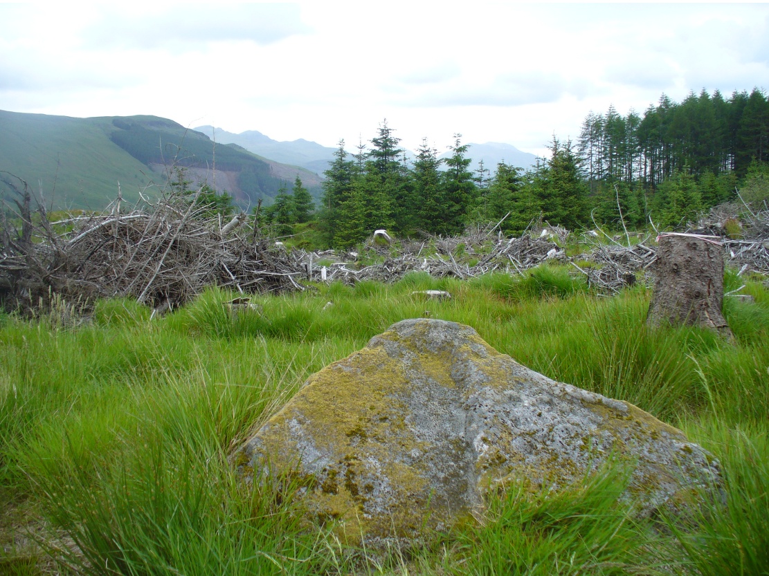
As you go along the road between Lochearnhead and Crianlarich, about 200 yards before reaching the turning to Killin, stop at the Mid Lix dirt-track. Cross the road and walk back uphill for about 75 yards, then walk into the denuded remains of the forest. There are several notable rocks peeking up from the wood, one of which has many well-formed cup-markings on, about 25 yards from the roadside. If you look around here, you’ll find it.
Archaeology & History
Mr Cash’s 1912 drawing
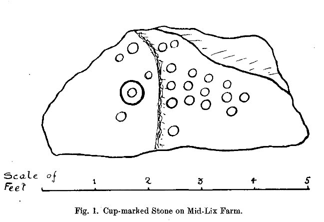
This seemingly isolated petroglyph, still in a very good state of preservation, was first reported in the 19th century by a Mr Haggart (1883), who described it in a letter to the late great J. Romilly Allen. He wrote:
“I have also, since you last wrote to me, discovered another cup-marked stone at the farm of Mid Lix, near Killin. It is a very good specimen, with between sixteen and twenty marks, well cut and distinct. I was passing the farm three weeks ago, and I thought, from the name Lix — which is a Gaelic word corrupted from Lie, the plural of Leac, a tomb-stone or flagstone — that it was very likely to have stones with marks, and I asked John Little, farmer, to keep a look out for such. He did so, and found the one mentioned within twenty yards or so of the road leading to Killin Railway Station, and between the farm and the roadway, due west of the farm-house.”
Subsequently, thirty years later Mr Cash (1912) visited and described the petroglyph in more detail in his survey of sites around Killin. He told that,
“In 1882 or 1883 this was reported to Mr Allen by Mr Haggart; it was shown to me by Mr Haggart. It lies about 100 yards south of the railway, and 20 yards east of the Glen Ogle road. It is a low triangular pyramid; the cups are on the west face, which lies at an angle of about 35°, and measures 5 feet across its base, and just over 3 feet along its median line. It carries twenty-one cups, as shown in the figure. One cup has round it a ring 6½ inches in diameter. The cups vary in diameter from 2¼ to 3 inches, and in depth from ¼ to ¾ inch. In his paper on “Cup-marked Stones near Aberfeldy,” read in 1884, Dr Macmillan said that he did not know a single example of a concentric ring round a cup on the stones found on the shores of Loch Tay or in Glendochart or Glen Lochay.”
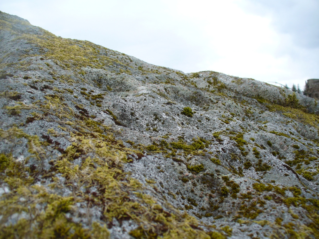
Cluster of cups, close up
When we visited the site earlier, the grey clouds prevented us getting good images of the carving and made visibility of the design more troublesome (typical rock art dilemma!); but we counted a minimum of 23 cup-marks on the stone. There is a small cluster of small rounded stones around the west and north-western base of the stone, but whether these are collected rubble or the denuded remains of a cairn could not be discerned upon our visit.
Morris, Ronald W.B., The Prehistoric Rock Art of Southern Scotland, BAR 86: Oxford 1981.
Royal Commission on the Ancient and Historical Monuments of Scotland, The Archaeological Sites and Monuments of Stirling District, Central Region, HMSO: Edinburgh 1979.
Along the A84 road between Doune and Callander, take the tiny country lane up to your right to Drumloist (if you’re coming from Doune) or up the tiny unmarked road past Keltie Bridge on your left (if you’re coming from Callander). Uphill for several miles, you eventually emerge from the trees and are on the top of the tiny road. Once here, keep your eyes peeled for Drumloist farm. Best thing to do is walk up the track and ask at the farm. The fella there is a superb old Highlander who’ll point you to the place on the hill above.
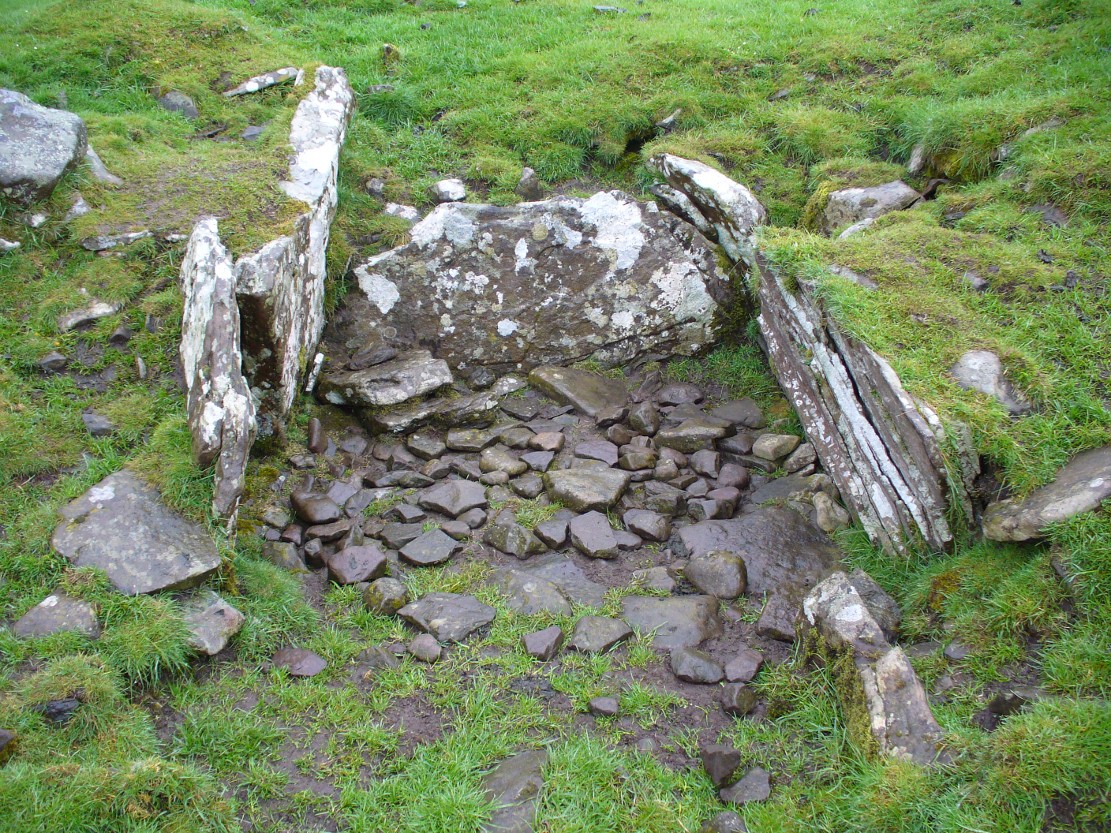
Archaeology & History
A site that was never explored by that giant of chambered tomb research, Audrey Henshall. A pity, as it has a lot of potential and seems to have a lot more to say about itself than the meagre findings reported by the Scottish Royal Commission doods.
Curious fairy mound to rearOne of two main chambers
Although there’s a very notable “fairy hill” eminence close by which strongly draws your attention, the actual hillock upon which this chambered tomb was constructed is in front of this, closer to the farm. A couple of rows of ancient walling—Iron Age by the look o’things—run up the hillside, with one of them running into the eastern sides of the huge mound which this tomb plays a part in. The mound itself is about a hundred feet across, although seems to have been damaged over the centuries. Although it is probably neolithic in origin, sections of the monument seem to have been altered and re-used for other purposes, giving it that distinctly multi-period look.
The farmer informed us how some of the stones from the mound had been robbed and used in some of the walling in the past. He also told us how there are so many other archaeological features upon the moors above here that remain to be “officially” recorded, despite the efforts of some who swept the region for remains a few decades ago.
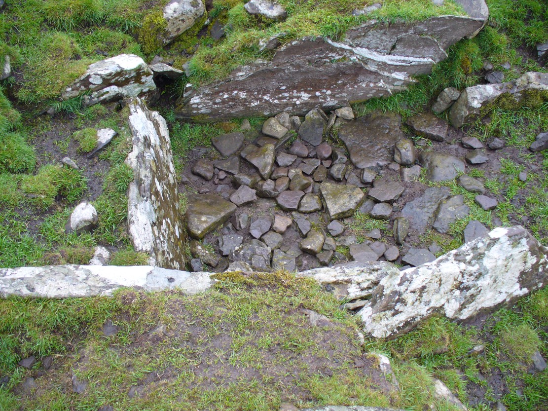
Looking into the main cistNature’s faded cup&ring
The main prehistoric section of the tomb that can be seen are the two opened cists, or stone-lined graves, to the top north-western edges of the mound. They align together, NE to SW, with a gap of about three yards between the two open tombs. The more northerly of the two is much more overgrown; whilst the southwestern grave comprises of three large flat upright stones, forming a traditional ‘box’ with smaller flat stones lining the floor. But these two separate tombs (if indeed they were originally separated) point directly to the large, very prominent “fairy mound” about 100 yards north-east, on the north side of the Drumloist Burn. The alignment seems very deliberate.
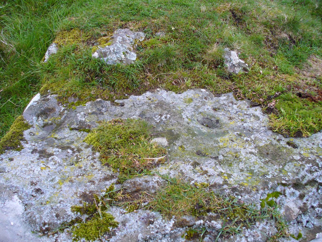
Walking over the boggy ground to the (unnamed) fairy mound, a natural ‘platform’ of rocks sticks out on its south-easterly side, and upon this are what I initially thought were two cup-markings, with the more easterly one of the two seeming to have a carved arc along its edge; but subsequent visits here at different times of day has shown that they are Nature’s handiwork. Anyhow, looking from this mound, back across to the Ballachraggan tomb, the open flat landscape heading south-west is held where the sunset falls. Sadly on the day we visited, Nature greeted us with grey cloud and the drizzle of light rain all afternoon, so we couldn’t make out if there was something, far away, which the tomb was truly aligned with… A damn good site though!
Whilst I’m in Glasgow (big thanks to Aisha!) I thought I’d check out any remaining heathen sites that might still be visible. Many have perished of course, beneath the weight of religious industrialism—this one included. Even when the Ordnance Survey lads came here in 1858, it had already been destroyed. All that we now know of it comes from the writings of the earlier historians like Walker (1883), Renwick (1921) and co.
Known in early records as St. Theneu (mother of the legendary St. Mungo, who also had sacred wells dedicated to him in Glasgow, Gleneagles and much further afield), trackways and burns hereby were also named after this curious character, and a chapel was also commemorated to her, which fell into ruin several centuries ago. Its position was highlighted on a late-16th century sketch of Glasgow village—as it was then—immediately south of the chapel, just north of the River Clyde. The best description we have of it comes from a detailed paper on the holy wells of Glasgow by a Mr Brotchie (1920), who told:
“Where the subway station of St. Enoch’s Square stands…there was at one time the well of St. Tenew, the mother of St. Kentigern or Mungo. It is thus described by a writer in 1750, “The ruins of a small chapel stood beside the well whose waters were sheltered by a bush, on which were to be seen, especially in early summer, bits of rags of all kinds and colours, while in the well itself enterprising boys were wont to get small coins. The rags and the coins were the offerings of people, principally women, who came to drink of the waters of St. Tenew’s Well, and left these trifles as thank offerings.”
“This ancient well of St. Tenew stood near a chapel erected over the tomb of St. Tenew, and the ground in its vicinity remained sacred in the eyes of the faithful as the last resting place of the holy woman who had watched the infant steps of the great apostle of the Cambrian Britons, St. Mungo, the patron saint of Glasgow. The Trongate and Argyle Street, which now stretch westwards from the cross, were in old times a country road leading to St. Tenew’s chapel, kirkyard and holy well. In a deed of 1498 mention is made of “the blessed chapel where the bones of the beloved Tenew, mother of the blessed confessor, Kentigern, rest.” When M’Ure wrote his History of Glasgow in 1736, the remains of this old chapel and kirkyard were described as standing “in a solitary spot in the country surrounded by cornfields.” Looking westwards from St. Tenew’s Well in 1750, a writer describes the scene as “open country, pastures and cornfields, rude-looking country homesteads, barns and other farm buildings, and enclosed kailyards,” where now stand the busy arteries of Jamaica Street, the Caledonian Railway Station, and the miles of tenements that stretch westward to Anderston, Finnieston and Partick.
“We have a comparatively recent record of the holy well of St. Tenew in the statement of the late Mr Robert Hart, who told M’George that he had been informed by an old man, a Mr Thomson, who had resided in the neighbourhood of St. Enoch’s Square, that in the beginning of the last century, say 1800, he recollected the well being cleaned out, and of seeing picked from the debris at the bottom many old coins and votive offerings. St. Tenew’s Well was a holy well. For centuries it was a place of pilgrimage and was much resorted to for cures, especially in pre-Reformation days. In 1586, James VI, addressed a letter to Mr Andrew Hay, commissioner for the west of Scotland, condemning the practice of people making pilgrimages to wells and chapels, but the royal edict was powerless to stop the practice and St. Tenew’s Well was resorted to by people in trouble as long as it was in existence. The road that led to it was known up to the 15th century as St. Tenew’s Gait or path. Indeed, it was so named till 1540, when the name of Trongate begins to make its appearance in old city deeds. This name, of course, owes its origin to the granting in 1490 by James IV, to the Bishop of Glasgow of the privileges of a free tron in the city—hence our Trongate of today.”
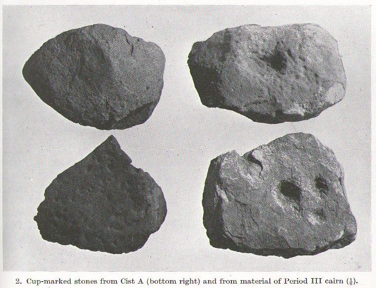
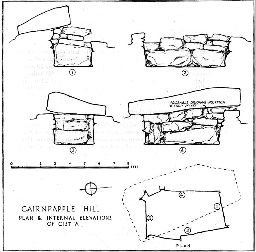
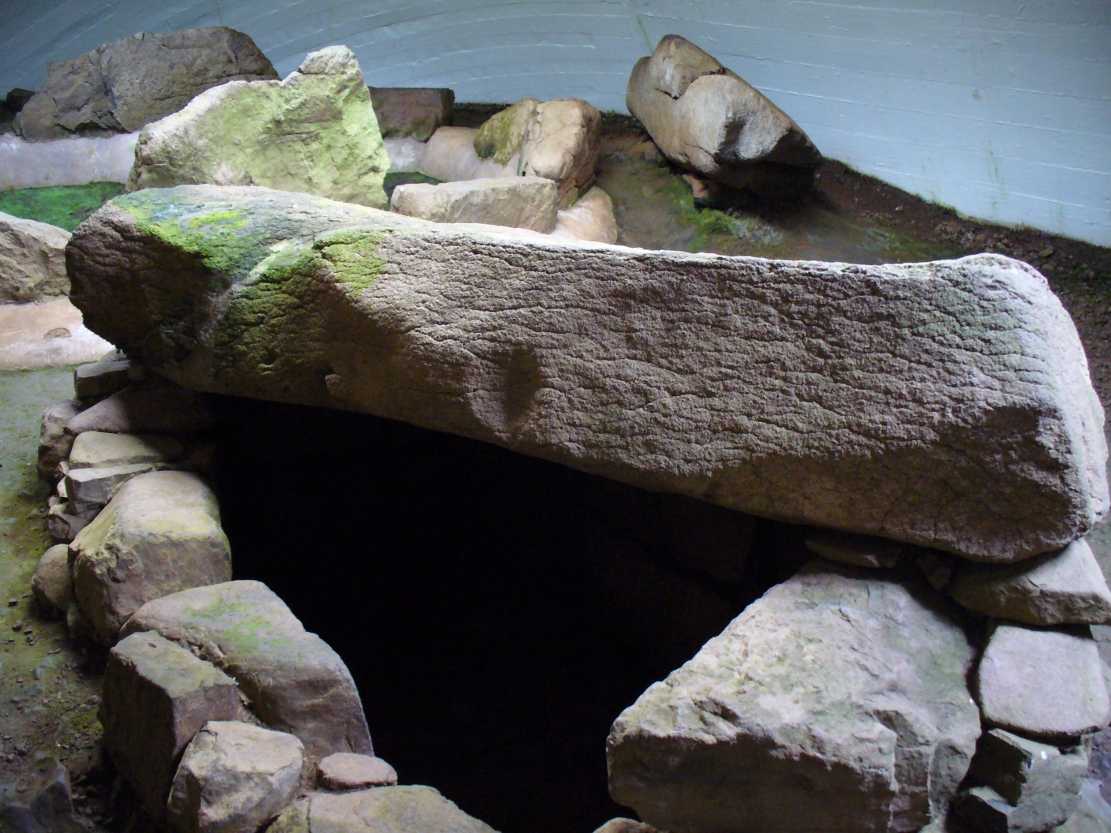
A profile of two seemingly trivial cup-marked stones is called for, out of memory for the carvings and also because they are now hidden in some vault somewhere, out of view in one of the Scottish museums I presume. In visiting the impressive Cairnpapple Hill the other day, I thought that the carvings should really be in situ, where they belong, and not in a box somewhere for the eyes of just a privileged few.
Cairnpapple Cist A
Two small, single, almost portable-sized stones—not unlike other cup-marked rocks found at sites like the Little Skirtful of Stones and elsewhere—were unearthed during the primary excavation of Cairnpapple by Stuart Piggott in the late-1940s. Although there are many stone-lined cremation pits and graves at Cairnpapple, only one of the tombs seemed to possess any carvings—and these were found only in the western walling in one of the larger of the two tombs that are now housed inside the modern covering tumulus, in what Piggott (1950) called ‘Cist A’. (Curiously in all sketches of the tomb, he didn’t show where the carvings were found, typical of some archaeologists of that period who saw little importance in these relics.)
Cist A capstone, with large cup
The giant stone roof or covering stone to Cist A also has a large worked cup-marking on its western side. There are also what seems to be other faint rectangular etchings on the same rock-face, but the age and nature of these elements need to be assessed with some caution.
References:
Cox, Adrian, Cairnpapple Hill, Historic Scotland: Edinburgh 2010.
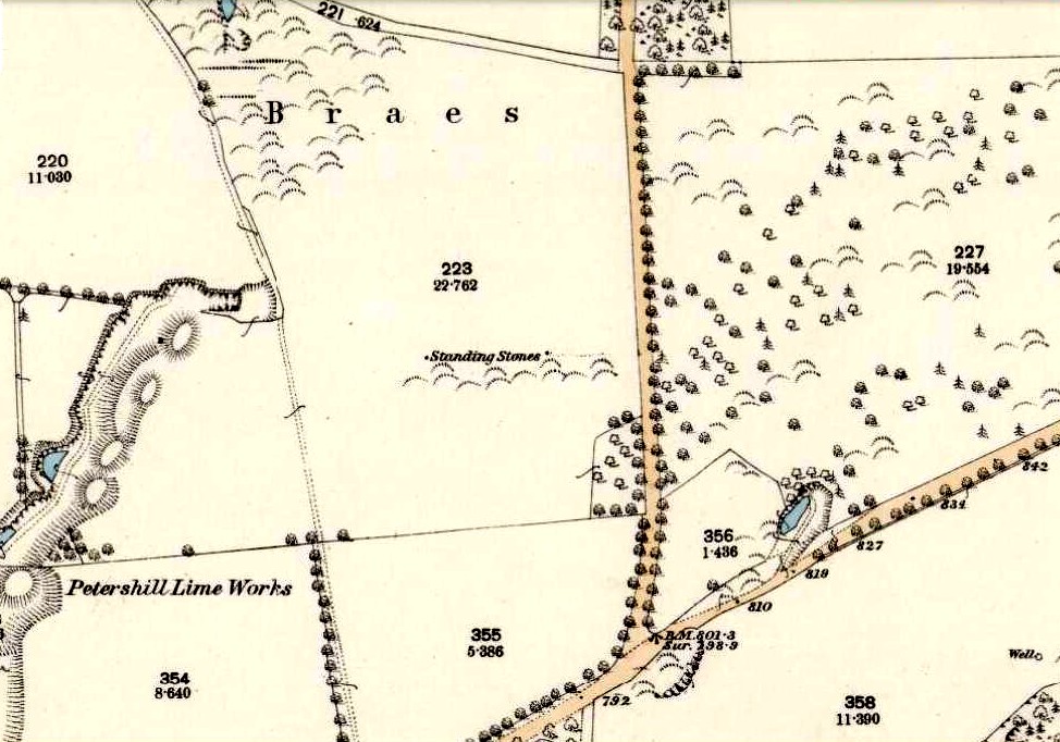
Various ways to get here: from Bathgate either take the Drumcross Road eastwards and up, or north up the Puir Wife’s Brae till you reach the crossroads where, upon the hillock north, you’ll see the old stone standing on the ridge. If you come down from Cairnpapple Hill (as most visitors are likely to do), go south for more than a mile and keep your eyes peeled in the fields to your right, shortly before the staggered crossroad. You can’t really miss it.
Archaeology & History
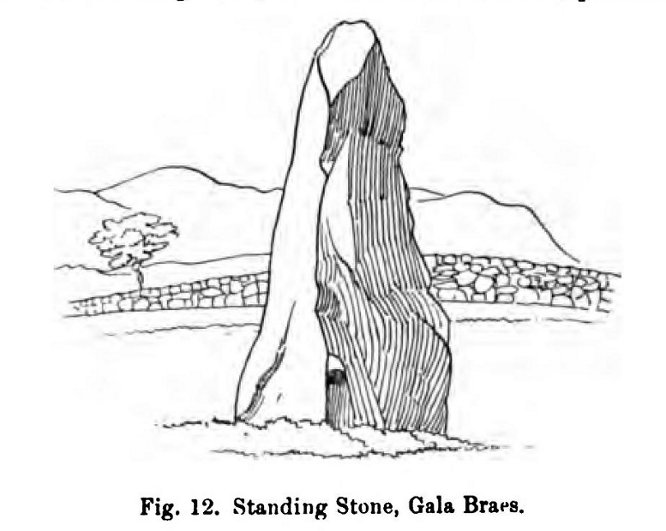
Gala Braes standing stone
About a mile south of the superb Cairnpapple Hill, in a well-manured field at the edge of a small ridge with a vast view to the south and west, this now-solitary standing stone lives quietly and alone, gazing over its old landscape. Standing about 5½ feet tall, it seems as if the monolith has been split along its southern side at some time in the not-too-distant past, leaving a damaged wedge-shaped monolith, with one very thin eastern edge and a wider western side. The stone itself was erected to align roughly north-south-east-west.
The monolith was first shown on the 1854 Ordnance Survey map of the region, along with its fallen companion (Gala Braes 2) nearly 75 yards to the west, but descriptions of the place by antiquarians are scarce. Not until Fred Coles (1903) visited here did we gain a decent account. He wrote:
“I examined this site in August 1902. It is about a mile to the east of Bathgate, and occupies the summit of a ridge extending some 300 feet westwards of the byroad that branches off due N, near the farm of Clinkingstane. The ridge is about 850 feet above sea-level. On reaching it, I found but one Standing Stone,—a rough whinstone boulder, split very unevenly, and jagged on the south side, very smooth on the two shorter sides, and girthing at the base 10 feet 5 inches. The longest edge trends WNW and ESE. It stands 5 feet 3 inches high and occupies the highest spot on the ridge.”
Whilst Mr Coles was pottering about, the courteous local farmer approached him and they began chatting about the old place—as tends to happen more than often in olde Scotland. When he,
“…asked if any digging had ever been made at either of these stones, Mr Carlaw replied that many years ago an old Bathgate worthy known as “The Apostle” persuaded his (Carlaw’s) father to dig at the base of the upper Standing Stone (the one at present erect), and they found human bones. The farm of Gala Braes has been in the tenancy of a Carlaw for upwards of a century.”
Whatever became of the old bones isn’t known. A few years later, the Royal Commission (1929) lads bimbled over to check the place out and found that it was still very much as Coles had described more than twenty years earlier, but added, “it bears no trace of sculpture.” This has since changed. Faint outlines of lettering, seemingly only a hundred years old perhaps, have been etched onto its northern face. As for the etymology of this place, Coles (1903) suggested:
“Assuming, however, that the bones found at the upper Stone were human, and taking cognisance of the fact that throughout Scotland there are many knowes, hills, hillocks and laws which are distinguished by the epithet Gallow or Gala, and that in or at many of these human remains and interments (some of them prehistoric) have been discovered, we may place this site on the Gala Braes of Bathgate in the same general group.”
Gala Braes, with Cairnpapple Hill to rearFred Coles’ 1903 drawing
Curiously he makes no mention of the nearby ‘Clinkingstane’ a few hundred yards east: an etymological curiosity that Angus MacDonald (1941) thought may have derived from a “knocking stone”; but is a word with hosts of dialect meanings, making it difficult to define with any real certainty (at the moment anyway). Just past the Clinkingstane we had the “cross on the ridge” of Drumcross—on the same ridge as our standing stones—which may well have been an attempt to keep people away from our older, more authentic heathen heritage.
The late great Alexander Thom (1990:2:341) also visited the site, but despite its impressive landscape setting and relative proximity to Gala Braes 2, he could find no astronomical orientations here. For Thom, that’s a feat in itself!
The Runwell (copyright with permission http://www.spiritrealms.co.uk/gallery.htm )
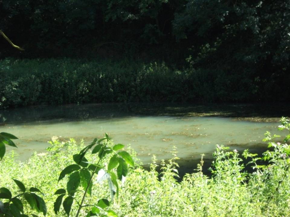
It can be found by taking a road off the A132 (Wickford Road) which leads to Stock (directly opposite the Parish Church), continuing until you reach another minor road to Rettendon. A short way up this road it forks. Take the road to the right & continue until one reaches a minor drive to Poplars Farm (distinctive with its trees each side of the drive). Continue up here until one passes the house to a small piece of tarmac. Here a footpath continues directly in front, continue until one reaches on the left a gate. Enter through here, and head across the field towards a notable tree, and a gap in the hedge. To the left, follow the edge of the field, until one sees another opening into the well. The approach from the south is the only route worth considering as northerly access is blocked by a fence. It can be extremely muddy, so good footwear is advisable.
Archaeology & History
Philip Morant (1763-8) is the first to mention it, suggesting that the settlement is named:
“..from a considerable Running well in the Parish.”
Again, Chandler (1896)—noted in Collins (1986)—emphasises:
“a remarkable spring of water on Poplars Farm, which is always running and has never been known to fail.”
Despite this obvious assumption, Ekwall (1936) suggested that the prefix originates from O.E rune for ‘mystery’ or implying a well possessing a secret of some religious observance. This is suggestive of the strange legends and traditions involved with the site. Alternatively it could derive from hruna referring to the tree trunk—and it does arise in a copse. A roman road runs by here.
The only reference to a religious site appears to be in 1602 when the parish register records ‘Shrine of the Bl. Virgin of RunnyngeWelle’. However, stone remains found over the years around the well may support the idea of a well chapel; these remains were two pieces of limestone window mullion and a piece which appears to be part of a step as well as pieces of Kentish ragstone.
Folklore
According to Bazille-Corbin (1940), Runwell is steeped in lore and legend. One must take these stories as possible antiquarian fancy as there does not appear to be any concrete evidence for them. Doubtless some of it is true, other bits not. He states that in the Sixth Century AD, Christian missionaries Lucus and Lucilus visited Essex and found a scene of paganism here, built a chapel, and rededicated the well to “Our Lady St Mary.” The floor of this chapel had a unique designed cross, with black flint and red strawberry stone, to show the teachings of the tenets of the Christian Faith.
To protect this and collect subsequent devotional gifts, a nunnery, of six members, was developed around the site. They tended to the shrine, well head and the statue of Our Lady, to which many miracles were attributed. Little evidence exists concerning this foundation, but it is believed to have been dissolved in the 16th Century. Locally it is said parts of the nunnery were incorporated into the nearby farm-house ‘The Poplars’. In the 1980s, Andrew Collins, searched for records of this local priory, but found none.
Another legend connected with the well accords that a young nun, Sister Lucy, after renouncing her vows, found the outside world not to her liking and returned in repentance, one snowy night, to the chapel for forgiveness. Yet, upon reaching the chapel steps, she slipped and fell into the icy waters of the well. (cf. The Single or St. Thomas’ Well at Ifield, Kent)
Her ghost is said to haunt the area, preserving perhaps the memories of these past water deities. This is enforced by the belief by some authorities that the well’s dedication indicates a Christianisation of the Iceni goddess Epona. This is supported by these horseshoe-shaped motifs, and that the approach to the well being haunted by a horse.
Andy Collins (1986) was informed that a concrete water tank was installed over the spring. This proved to be inaccurate, but the well was defined by a concrete chamber. Collins thought that this may be the remains of some adaptation for a spa bath, but no hard evidence was forthcoming regarding this.
It certainly had passed through considerable years of neglect, as noted by the Runwell Rector John Edward Bazille-Corbin (1942), who said it was “in much need of dredging and cleaning out.”
The photo shown in Collins’s (1986) work shows a concrete lined rectangular pond, defined by corrugated iron. He was thus responsible for its repair and clearing away the years of neglect, also revealing the concrete rectangular pond, which was reached by a series of steps from its north side. A flight of steps appear to enter the well itself from the front. The body of water is of considerable size and depth and one could easily immerse oneself in it. When I last visited here, the water appeared murky but a sample revealed (apart from the pond fauna) a remarkable clarity.
Within recent years the well appears to have attracted a ‘cult following’, clearly manifesting itself in two ways. One is a seasonal Boxing Day walk to the well started in 1975, which is still undertaken (see link, below). The other more traditionally is the attachment of rags or cloutties to the surrounding shrubbery. Such activity, although probably done by those ‘in the know’ rather than any continuation of any local tradition, is the only such example I have come across in East Anglia—although recent photographs fail to show this and it appears that the tree has been cut down where these have been placed and the area opened up.
References:
Bazille-Corbin, J. E., Runwell St. Mary: A farrago of History, Archaeology, Legend and Folk-lore, 1940.
Collins, Andrew, “Devilish Mysteries at Runwell,” in Essex Countryside Vol. 33 no.431, p38-39, 1985.
Collins, Andrew, The Running Well Mystery, 1986.
Ekwall, Eilert, Studies in English Place and Personal Names, Lund 1931.
Ekwall, Eilert, The Concise Oxford Dictionary of English Place-Names, Oxford 1936.
Morant, Philip, The History and Antiquities of the County of Essex – 3 volumes, London 1763-8 (reprinted by EP: Wakefield 1978).