From Menstrie, walk up the path behind the post office and head up onto the hills, following the track that runs up alongside the Menstrie Burn. After about 500 yards, crossing a stream, the path has a sort of hairpin kink and, shortly past this a smaller path leads off up into the grasslands on your left. The standing stone can be seen up this path about 100 yards up.
Archaeology & History
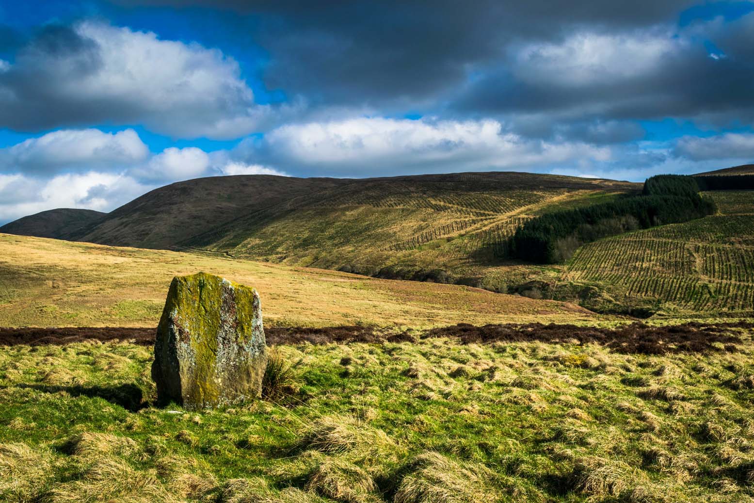
The Lipney Stone
We came across this small standing stone, less than four feet high, after running and jumping down the steep eastern slope of Dumyat at some speed — or rather, Naomi came across the little thing and then told me about it after I’d run round and further down the slope towards the upper stretches of the Menstrie Burn (I was knackered!).
It’s a curious little thing inasmuch as it stands here alone, with no other companions close by; although there were a number of other stones scattering the grasslands hereabouts and other stones may await discovery. Little seems to have been said of the site. The Canmore record tells:
“It measures 1.1m in height, 0.7m in breadth and 0.4m in thickness, and is aligned with its long axis NE-SW. It rises with straight sides and leans to the SE.”
There are extensive remains of earthworks scattering the slopes hereby, though much of this seems medieval in nature. Any further information about this old stone would be much appreciated!
If you’re not into the walk, get the bus running NE between Dunblane and Greenloaning — the A9 — getting off at the Little Chef on the dual carriageway and cross the road, walking up the track to Upper Whiteston Farm (the owners here are very helpful). As you walk up the track you’ll notice the large upright in the edge of the field a coupla hundred yards to your right. That’s the one!
Archaeology & History
This is a mightily impressive site if you’re into yer megaliths! When it was visited and measured by Mr Hutchinson (1893) in the 19th century he found it to be 9ft 4 in tall; and although it seems quite isolated at first sight, we find that there is another large stone companion laid down not far to the north of here which may have had some relationship with it . But that aside… There are also as many as eight cup-markings on the stone’s eastern face: one large one and seven smaller ones, in no particular order as usual! It was these cup-marks that gave me the impression there was once a burial associated with the stone, but the archaeology records seem silent on such a matter; though folklore tradition tells another story…
Folklore
Mr Hutchinson (1893) told that the legend attached to this stone appears to be “of quite recent date.” He said how,
“In the district the stone is known as the MacGregor Stone, and the tradition accounting for the name is to the effect that here a countryman was sacrificed by the followers of Rob Roy, when forming for the engagement on Sheriffmuir, in order to satisfy the ancient Highland superstition that first-blood was an infallible omen of success… The tradition is precise enough to state that a man of the name Dawson was seized in the adjoining hamlet of Whiteheadston (for such is the orignal name) as a whig, and therefore a foeman and proper victim. Dawson, however, suspecting the intentions of the captors, vehemently professed himself a supporter of King James and was left off. But another inhabitant of the hamlet not so acute or not so hypocritical, was immolated at the stone.”
Hutchinson however, doubts the accuracy of the tale and suggests that the local name of the MacGregor’s Stone derives from the fact that the monolith stands upon land once owned by the MacGregors of Balhaldies, countenancing that the stone “is of much earlier date than the MacGregors of Balhaldie or any other sept of the Children of the Mist.” I think he’s got a point!
References:
Hutchinson, A.F., “The Standing Stones of Stirling District,” in The Stirling Antiquary, volume 1, 1893.
From the tourist-infested (but lovely) town of Callander, look west to the largest of the nearby mountains — that’s where you’re heading! You can keep along the A84 road out of the town for 4-5 miles (past the Falls and Pass of Leny) till you reach the parking spot on your left. Cross the river and go up into the signposted woodland. Keep walking up thru the trees until the rocky mass emerges above you. You can either keep to the path and follow the long walk round the mountain, or go straight up the crags above you. The top’s in sight!
Folklore
Getting up here is no easy task if you’re unfit — but it’s well worth the effort for the journey alone! And in bygone centuries it seems, local people made it a particular pilgrimage at specific times during the year. Even the name of this great hill has some supposed affinity with holy issues; though some modern english etymologists put a dampener on such things. In Charles Rogers’ (1853) excellent Victorian exposition, he told that,
“Benledi is an abbreviation of the Celtic Ben-le-dia, signifying the hill of God.”
But whether the old heathens who named most of these ancient mountains would echo his oft-repeated derivation is another thing altogether! However, there are other decidedly pre-christian events that used to be enacted here, for the summit of Ben Ledi was, tradition tells, where the sun god was worshipped. It would seem, however, that this tradition is a somewhat watered-down version of it as a site of cosmological and social renewal. (see Eliade 1974) For akin to the annual pilgrimage that happens upon Croagh Patrick in County Mayo, Ireland, here upon Ben Ledi,
“For three days and three nights…the inhabitants of the district in those primitive times convened, at the period of summer solstice, on the summit of the mountain, to join in the rites of heathen worship.”
More recent lore tells the date of such sacred gatherings was Beltane. Also a short distance to the north of the summit of Ben Ledi is a small loch known as Lochan-nan-corp. Mr Rogers again tells us that,
“Here two hundred persons, who were accompanying a funeral from Glenfinglas to the churchyard of St. Bride, suddenly perished; the ground had been covered with snow and the company were crossing the lake on the ice, when it at once gave way.”
It seems a most unusual event. But the tale itself implies that a corpse route passed by the way of this high summit, down to the heathen chapel of St. Bride at the bottom of its eastern face: a huge undertaking in itself with probably archaic origins. Does anyone know owt more about this?
References:
Eliade, Mircea, The Myth of the Eternal Return, Princeton University Press 1974.
Eliade, Mircea, Patterns in Comparative Religion, Sheed & Ward: London 1958.
Roger, Charles, A Week at Bridge of Allan, Adam & Charles Black: Edinburgh 1853.
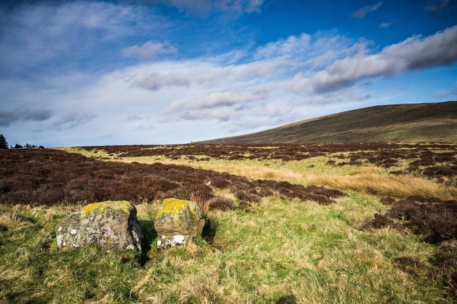
An intriguing entry inasmuch as we don’t know the full history and nature of the site. Whether this site was the “druidical circle” mentioned in the 1791 Old Statistical Account of Scotland ” upon the heights of Sheriffmuir,”(vol.3, p.210), we cannot be sure. The site was certainly described by Mr Hutchinson (1893) more than a century ago as a “stone circle”, but earlier still in a short piece in the Stirling Journal of May 5, 1830. It read:
“About eight miles from Stirling by the Sheriffmuir Road, near a place called Harperstone, there is a remarkable circle of stones, supposed to have been a druidical place of worship of old. The site of this circle is rather uncommon in this country — being on the back summit of a high hill, one of the Ochils called the Black Hill, and exposed to every wind that blows. It is about two english miles south of the present roadway.”
The writer’s notes then told of some curious finds by this circle, giving the impression that it may have had another function: perhaps a cairn of sorts; perhaps an ancient building — we may never know. Nevertheless, his information is intriguing.
“Tradition records two remarkable circumstances connected with this druidical circle, which may perhaps be worthy of being preserved. About the middle of last century (c.1750) there were dug up at the foot of the larger stones three vessels of clay of antique shapes, containing coins of very ancient date, which were long preserved by Monteath of Park, but are now, we regret to say, lost. So late as 1770, these coins were, it is said, to be seen at Park House, all of gold. About the year 1715, some stones on which had been engraved inscriptions were dug up at the same place; and at a previous period specimens of ancient Pictish armour were dug up from the bowels of this hill, which had been carefully deposited of yore some feet below the surface in crypts of curious description.”
When Mr Hutchinson came to explore this region in search of the stone circle, his nose took him to a site a few hundred yards north of nearby Harperstone Farm, where he found a large stone:
“It is 9 feet long by 6 feet across on the top, is 3 feet thick and measures 26 feet round. This appears to have been a centre stone, and a surrounding circle is traceable more or less distinctly — moreso to the west and north, less so to the east and south. The radius of the circle is about 15 yard, and a similar distance separates each of the larger stones yet traceable in the circle. The ground beside the great central stone appears to have been excavated…”
Black Hill, Sheriffmuir, looking eastArc of 3 stones in large ellipse
But it would seem that Hutchinson’s site and the one described in the Stirling Journal of 1830 are two distinctly separate items if their relative topographical descriptions are to be accepted. No doubt — like many a-local who’s found these same written accounts — when we visited and wandered back and forth over the Black Hill site in Autumn 2010, we were as puzzled as others before us in finding nothing on the named Black Hill. Nothing that could remotely be viewed as the circle described was anywhere in evidence. The only thing that we found of any potential was on the flat below the southern ridge of the hill, heading towards the small copse of trees, where is a possible ring of seven stones, albeit a low one, in an ellipse formation. The ground was much overgrown and a spring of water emerged from the edge of where might have been an eighth stone. The photo shown here was the best we could get of the site. It’s unlikely to be the place which Messrs Hutchinson and company wrote about.
A more detailed examination of the landscape around this ‘Harperstone Circle’ is needed.
References:
Hutchinson, A.F., “The Standing Stones of Stirling District,” in The Stirling Antiquary, volume 1, 1893.
From Dunblane Cathedral walk straight down town along High Street, but where the road bends to cross the river, keep to your left and onto the dual carriageway. Walk straight across and along the “private” drive that leads to Kippencross House. The first 100 yards is wooded either side of you, but when you come out into the grassy open, walk on for another 100 yards or so, keeping your eyes peeled for the rise in the grassland on your right, topped with a clump of trees. This is the cairn!
Archaeology & History
This is a lovely site, perched near the crown of a small hillock, surmounted with a crown of pinus trees that would have delighted Alfred Watkins and his ley-hunters. It is a veritable faerie mound, seemingly alone amidst this modernised but well-kept gardenscape. The large tomb sits upon a small rise in the land here, where the grasslands fall to its west and northern sides with some obvious deliberation.
Kerbstones on south side
The cairn doesn’t appear to have been excavated (but I don’t have my library to hand, so could be wrong – I’ll check when I get back home) and though there’s a distinct impression of cup-marked stones close by, we couldn’t find owt in our brief bimble here. The tomb measures about 20 yards across, and rises perhaps six feet or more above the ground level. Although a little overgrown with summer herbage (mainly Urtica and friends), quite a few small stones were visible close to the surface on different parts of the mound, looking like typical cairn material; though around its mainly southern edge is a line of larger kerb stones showing the outline of what would seem to be the edge of the monument.
The cairn is definitely worth having a look at if you’re in the area. It’s certainly a beautiful little spot to sit for a while…
References:
Royal Commission on the Ancient & Historical Monuments Scotland, Stirling – volume 1, HMSO: Edinburgh 1963.
Royal Commission on the Ancient & Historical Monuments of Scotland, Archaeological Sites and Monuments of Stirling District, Central Region, Society of Antiquaries of Scotland 1979.
Although this great and legendary cathedral is today a christian centre, it seems that the site had been deemed as sacred by a much earlier, indigenous culture — though on a scale much more humbling than the grand edifice we see standing here today! For in the northwest corner of the church grounds in 1928, a small burial cist was located. Years later, on October 2, 1975, following work here by the North of Scotland Hydro-electric Board to uncover the main supply “in an area adjacent to the north wall of the Lady Chapel,” they found a slab of stone which, when they lifted it up, covered what appeared to be a burial cist. Messrs Gordon & Gourlay (1976) narrated:
“The stone slab which the workmen had removed proved to be the western section of a larger slab which at some period had been fractured and the eastern section lost. As the interior of the cist was filled with soil similar to that surrounding it and containing a considerable quantity of dispersed human bone fragments, it was suggested that the eastern section of the covering slab had been lost when the drainage and/or electricity services were being installed. The upper surface of the slabs western section was c.35cms below ground surface. The dispersed bones in the cist were at first considered intrusive — possibly from old burials when the public services were installed — and an undisturbed deposition of bones at the base of the cist seemed to confirm this. However, an examination of the bones by Dr A. Young…and Dr D. Lunt…showed that the deposit contained remains of two adults and one child and that many of the dispersed bones could be matched with those in the undisturbed group. In fact, the deposition suggested a re-use of the cist.
“The cist measured internally 1.20m by 0.44m by 0.28m. It lay 8.4m east of the door of the Lady Chapel and 1.44m from the wall of the same. The cist was constructed from ten irregularly-shaped sandstone slabs, with one fractured slab forming the floor. On the south side, two smaller slabs had been placed on the inside of the wall to support the covering slab which only just fitted the cist, and to give extra strength to the wall since they overlapped the vertical joins of the three slabs of the south wall. The north wall slanted to meet the west-end slab 12cm from its edge, giving the cist a coffin-like appearance. The north wall was still vertical; the narrowing was probably intentional as the covering slab was only 33cm wide at that point and the bones lay apparently undisturbed, parallel to the north and south walls. It proved impossible to examine the old ground surface because of the public installations, but it did appear that the ground sloped to the west as the cist certainly did.”
Although the remains found here were not dated, it was initially thought that the cist may have been made around the period when the Lady Chapel was erected around 1250 AD.
“However, Mr J. Stevenson of the Royal Commission for Ancient and Historical Monuments pointed out that the dimensions and construction of the cist accord well with cists of known prehistoric dates in the area; the cist (therefore) would seem to be placed early in the sequences of cist development, assuming it to be prehistoric.”
References:
Cockburn, James H., The Celtic Church in Dunblane, Society of Friends of Dunblane Cathedral: Dunblane 1954.
Gordon, Alistair R. & Gourlay, Robert B., “A Cist Burial, Dunblane Cathedral, Perthshire,” in Glasgow Archaeological Society Bulletin, No.2, 1976.
Said by John Allan (1907) to be “at the base of the Brandy Hill, about 210 yards west from the parish church,” to get to it from the town centre Stirling Arcade, go across and along the Corn Exchange Road and as it goes down the slope, take the path that leads into the trees on your right-hand side. Follow this path along to the bottom of the woods. Once on the level at the bottom, walk on the path in the direction of Stirling Castle and eventually you’ll reach the fancy walling with the dried-up well right in front of you!
Archaeology & History
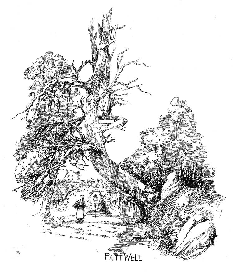
This much-neglected site got its name from there being a number of archery shooting targets, or butts, which used to be erected in the fields immediately below this once popular drinking spot. Although the Stirling historian J.S. Fleming (1898) could find no definitive records of the place as a holy or healing well, he told how,
“The copious spring arising in the centre of the rock on which Stirling Town and Castle are built, must have been extensively used during the Royal occupation of the Castle for watering the horses engaged in hunting in the Park…and it must also have been the source from whence the canal or ornamental waters and fountains in the ancient pleasure-grounds of the King’s Knot were supplied, the fall being amply sufficient for the rise to a considerable height of the latter… The Well had at one time a railing surroundings its then open trough, the marks of the lead used in grouting the rails remaining visible until the last alteration.”
The waters emerging in the field belowThe Butt Well
Early accounts of the Butt Well are few and far between. Ronald James (1899) found it to have been known in earlier centuries as the Spout Well in 1582, but additional descriptions of the place are scant. The well is not included in the surveys of either MacKinlay (1893) nor the Morris’ (1981), though John Allan (1907) thinks that this site was a “congenial retreat” where “the bard of the chief” would gain insight. The remains of walling behind the old well he thought may have been the ancient remains of an old hermitage of sorts, but there’s little evidence to prove this. Today, although dried-up, the site appears much it as did when Fleming described it:
“The Well has had the old wall — formed of granite boulders — rebuilt and cemented, and a rustic ornamental freestone front put on where the spout is inserted, but its stone seat for invalids and other surroundings remains as they were forty years ago. The Well formed the termination of the early morning walk of the town’s folk for a draught of its cold water, and was at a late period used by the wives and washerwomen of Stirling for washing their clothes, which were then bleached on the green sward lying below the Well, the tenant of the park making a charge according to the extent of the washing.”
If you go behind the walling here you’ll notice a small flow of water which emerges into the field below. The waters from here, although only a trickle, are still cold, fine and refreshing.
References:
Allan, John, The Days of the Monasteries and Latter Days of Stirling, Stirling 1907.
Fleming, J.S., Old Nooks of Stirling, Delineated and Described, Munro & Jamieson: Stirling 1898.
Ronald, James, Landmarks of Old Stirling, Eneas MacKay: Stirling 1899.
Follow the same directions as to reach the cup-marked Sheriffmuir Carving, which is just a coupla hundred yards away to the southwest. On a clear day you can see this standing stone from the pub by the roadside, a few hundred yards away!
This is alleged to be just one standing stone in a straight line of five once-upright monoliths. Starting at the southwestern end of this row we have the 7ft-long cup-marked Sheriffmuir Carved stone — which certainly looks as if it stood upright in the not-too-distant past — and as we move up the line we pass another that’s been split in half. Another earthfast-looking rock is the next contender, before we reach our famous Wallace Stone, standing upright and proud on this moorland ridge. It’s about 6ft tall and 3ft across at its widest and certainly acts as a marker for the line of stones that allegedly stood upright here. And if we walk just a bit further up we have another big stone laid on the ground which is alleged to be a part of the same alignment.
If it is an authentic megalithic row, it’s not included in either the Thoms’ (1990) two-volume work on the subject, nor Aubrey Burl’s (1996) compendium a few years later. And though the alignment looks good, I’ve found ones just like this in the Pennines where we have just one upright left and then a line of other seemingly prostrate stones running dead straight either side of the singular upright (and have kept mi gob shut about ’em for sensible reasons), so I’m not too sure what to think.
But, alignment aside, the Wallace Stone itself is a damn good standing stone and well worth checking out. It’s highly probable that other prehistoric remains still lurk, undiscovered, amidst these heaths…like the lost stone circle to be found nearby…
Folklore
A slight variation on a theme about this spot: in both accounts the stone was named after the legendary Scottish independence fighter, Sir William Wallace. The folklore tells that he and his fighting clans gathered here in 1297 preceeding the Battle of Stirling Bridge; whilst the variation tells that the stone here was actually erected around that time to commemorate the event. This tale was first narrated by a local story-teller called Blind Harry and was found by local historian A.F. Hutchinson (1893) to be a case of mistaken identity!
References:
Burl, Aubrey, From Carnac to Callanish: The Prehistoric Stone Rows and Avenues of Britain, Ireland and Brittany, Yale University Press 1993.
Heggie, Douglas C., Megalithic science: ancient mathematics and astronomy in north-west Europe, Thames & Hudson: London 1981.
Hutchinson, A.F., “The Standing Stones and other Rude Monuments of Stirling District,” in Transactions of the Stirling Natural History and Antiquarian Society, 1893.
Royal Commission on the Ancient & Historical Monuments of Scotland, Archaeological Sites and Monuments of Stirling District, Central Region, Society of Antiquaries of Scotland 1979.
Thom, A., Thom, A.S. & Burl, Aubrey, Stone Rows and Standing Stones – 2 volumes, B.A.R.: Oxford 1990.
From Dunblane, head up the Glen Road for nearly a mile, turning left up the Sheriffmuir Road and all the wya on till you reach the pub near the T-junction another couple of miles on. OK – get thru the gate and onto the moor, roughly in a straight line with the pub behind you for about 400 yards. You’re damn close! (if you find the nice standing stone known as the Wallace Stone, walk 250 yards southwest from here).
Archaeology & History
Almost nothing has been written of this cup-marked stone, found at the southern end of what’s alleged to be an authentic megalithic stone row alignment, running northeast to southwest — although this alignment isn’t included in either Aubrey Burl’s (1993) or Alexander Thom’s (1990) textbooks dealing with such matters.
Cup-marks highlighted in ice!Cup-marked rock with the Wallace Stone in the distance
When we came here last winter in temperatures of around -6°C (one helluva good day!), curiously only this and the other stones along this “stone row” were actually uncovered on the moorland. Quite bizarre to be honest! Many of the other rocks scattering this small moorland edge were covered in several feet of snow. We were lucky I s’ppose…though I’ve gotta get back up here again shortly and see the site in summertime (midges up mi crotch, cleggs-a-biting – oh such joy!) cos I can’t believe this is the only cup-marked stone hereby.
The rock itself is more than seven-feet long and has at least twenty archetypal cups carved into its slightly-slanting face — although when we visited the stone, several of these were difficult to see and, as the images show, even more difficult to photograph (of the 20 I took of this stone alone, only one was of any value in highlight the cups) . The stone gave the impression that it may have stood upright in the not-too-distant past — which would of course give the notion of this as part of megalithic avenue a considerably more potent status.
Some dood alleged that this potential stone row, with this cup-marked stone at its southwestern end, marked an astronomical alignment — but for the life of me I can’t remember who it was! (it’s my age creeping up on me at last!)
References:
Burl, Aubrey, From Carnac to Callanish: The Prehistoric Stone Rows and Avenues of Britain, Ireland and Brittany, Yale University Press 1993.
Heggie, Douglas C., Megalithic science: ancient mathematics and astronomy in north-west Europe, Thames & Hudson: London 1981.
Thom, A., Thom, A.S. & Burl, Aubrey, Stone Rows and Standing Stones – 2 volumes, B.A.R.: Oxford 1990.
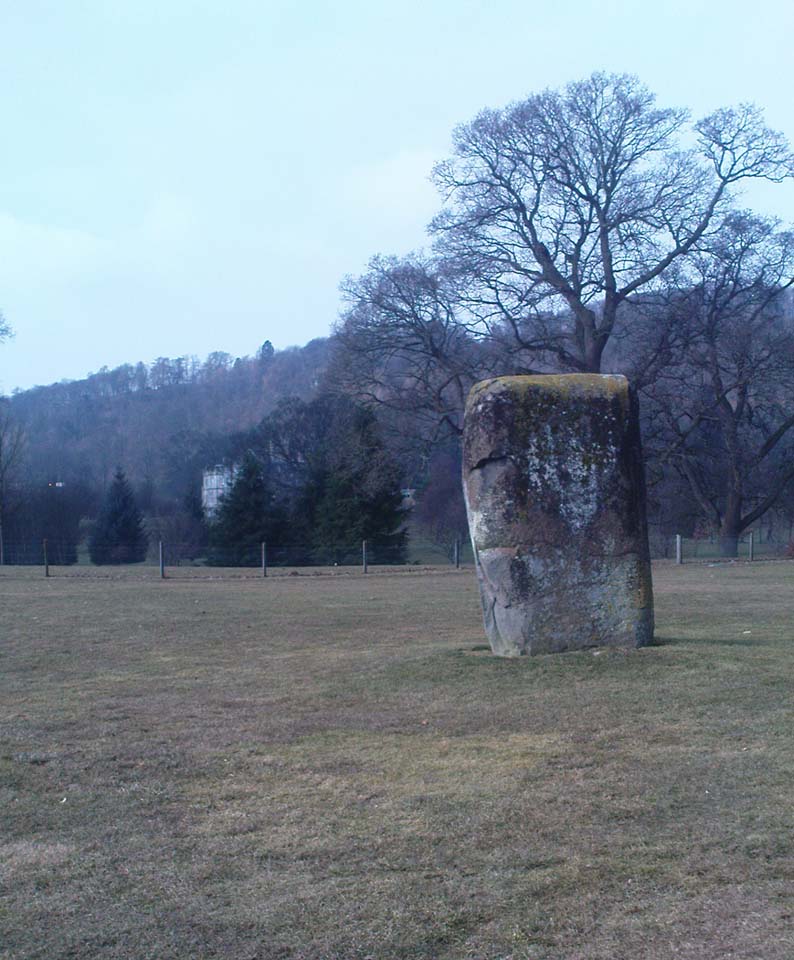
Dead easy to find! From Stirling head out on the A9 road towards Bridge of Allan and Stirling Uni. You’ll hit a small roundabout a mile out of Stirling – go straight across and up the little bendy road. Follow this round the bottom side of the Uni for a half-mile, watching out for the left-turn as the tree-line ends, taking you up to the factory behind the trees (if you hit the roundabout a bit further on, you’ve gone too far!). Go up the slope and onto the level sports playing fields – where this old beauty will catch your eye! If you somehow miss it, just get to the Uni and ask some of the students where it is!
Archaeology & History
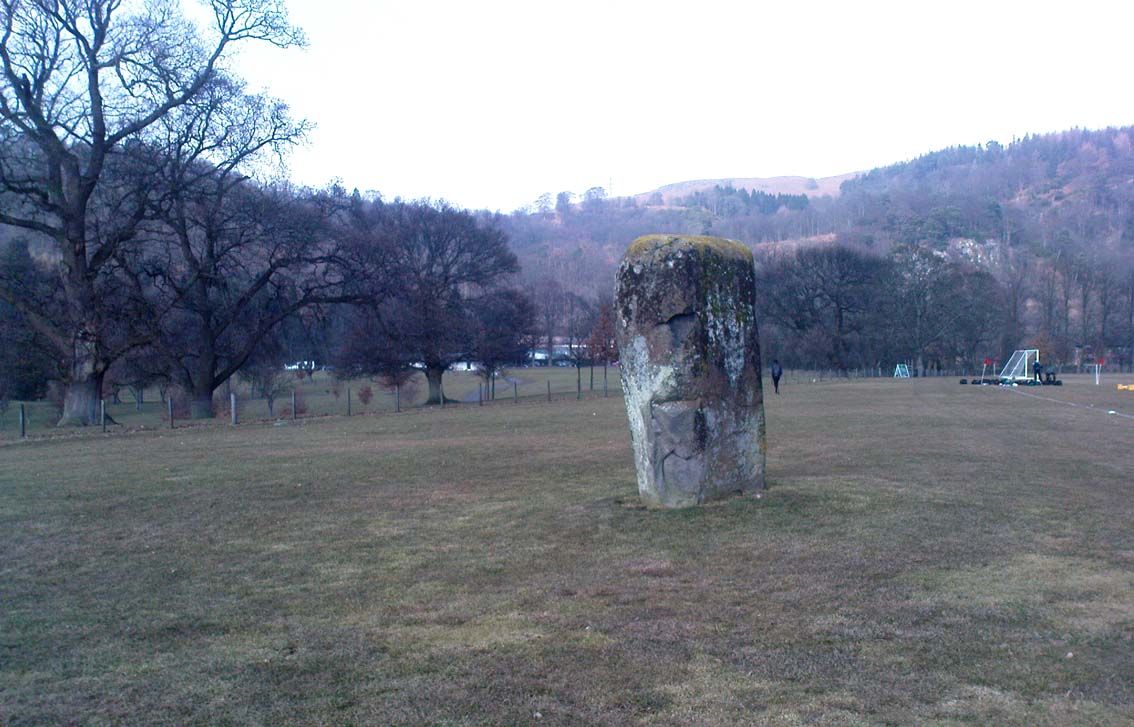
Airthrey Stone, looking NW
This single standing stone is a beauty! It’s big – it’s hard – and it’s bound to get you going! (assuming you’re into megaliths that is) Standing proud and upright on the eastern fields of the Stirling University campus, A.F. Hutchinson (1893) measured it as being “9ft 1in in height. Its greatest breadth is 4ft 10in, and its circumference 14ft.” A bittova big lad! More than fifty years later when the Royal Commission (1963) lads got round to measuring its vital statistics, only an inch of the upright had been eaten by the ground. The stone was highlighted on the earliest OS-maps of the area.
Folklore
Of the potential folklore here, most pens and voices seem quiet; although Mr Hutchinson (1897) told of William Nimmo’s early thoughts, linking the history of this stone with the others nearby, saying:
“Of what events these stones are monuments can not with certainty be determined. In the ninth century, Kenneth II, assembled the Scottish army in the neighbourhood of Stirling, in order to avenge the death of Alpin his father, taken prisoner and murdered by the Picts. Before they had time to march from the place of rendezvous, they were attacked by the Picts… As the castle and town of Stirling were at that date in the hands of the Picts, the rendezvous of Kenneth’s army and the battle must have been on the north side of the river; and as every circumstance of that action leads us to conclude that it happened near the spot where these stones stand, we are strongly inclined to consider them as monuments of it. The conjecture, too, is further confirmed from a tract of ground in the neighbourhood which, from time immemorial, hath gone by the name of Cambuskenneth: that is, the field or creek of Kenneth.”
And although this hypothesis is somewhat improbable, it was reiterated in the new Statistical Account of 1845, which also suggested that this and the other Pathfoot Stone were “intended probably to commemorate some battle or event long since forgotten.”
References:
Hutchinson, A.F., “The Standing Stones of Stirling District,” in The Stirling Antiquary, volume 1, 1893.
Royal Commission on the Ancient & Historical Monuments Scotland, Stirling – volume 1, HMSO: Edinburgh 1963.