Ostensibly non-linear carved designs, generally assumed to be Bronze Age in date, but many originate in the neolithic period (some may indeed date back to 5000 BCE). Their central features are small rounded cup-markings, circles, semi-circles, curved lines (short, mid-length, and long), straight-ish lines, double- and multiple-rings, all in usually abstract design-forms. Their almost complete non-linear nature relate to non-egoic structuralisms, making them difficult to ‘intellectually’ grasp. Added to this is that no two carvings are the same. Although no direct ‘meaning’ can be ascribed to the carvings, many of them have a relationship with ancient notions of death and/or burial. In animistic terms, they relate to the spirit of rocks and other features of the natural landscape. They have very little relationship with alignment features (though exceptions in some megalithic rings have been found). Some modern writers allege positive relationships with water, but this ingredient (if tenable) cannot yet be said with any certainty: the idea should be forged onto animistic relationships with the land itself.
From Baildon go up onto the moor, turning left to go round Baildon Hill and onto Eldwick, stopping at the car park at the top of the brow where the Acrehowe circle once stood. Cross the road and walk along past carving 184, making sure you keep right sticking to the footpath that runs along the edge of the slope (not onto the flats & up to Baildon Hill itself). There are several carvings along here, but this one’s on the right-side of the widening path, another 300 yards past carving 184. Keep your eyes peeled – y’ can’t really miss it!
Archaeology & History
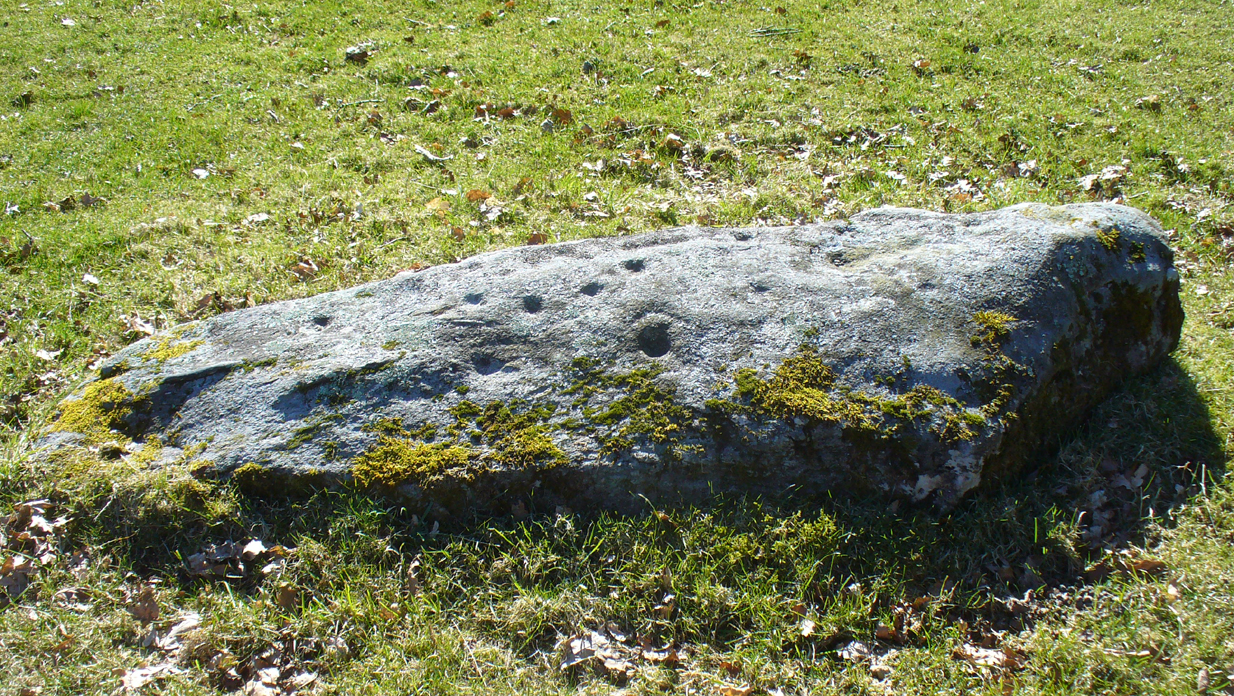
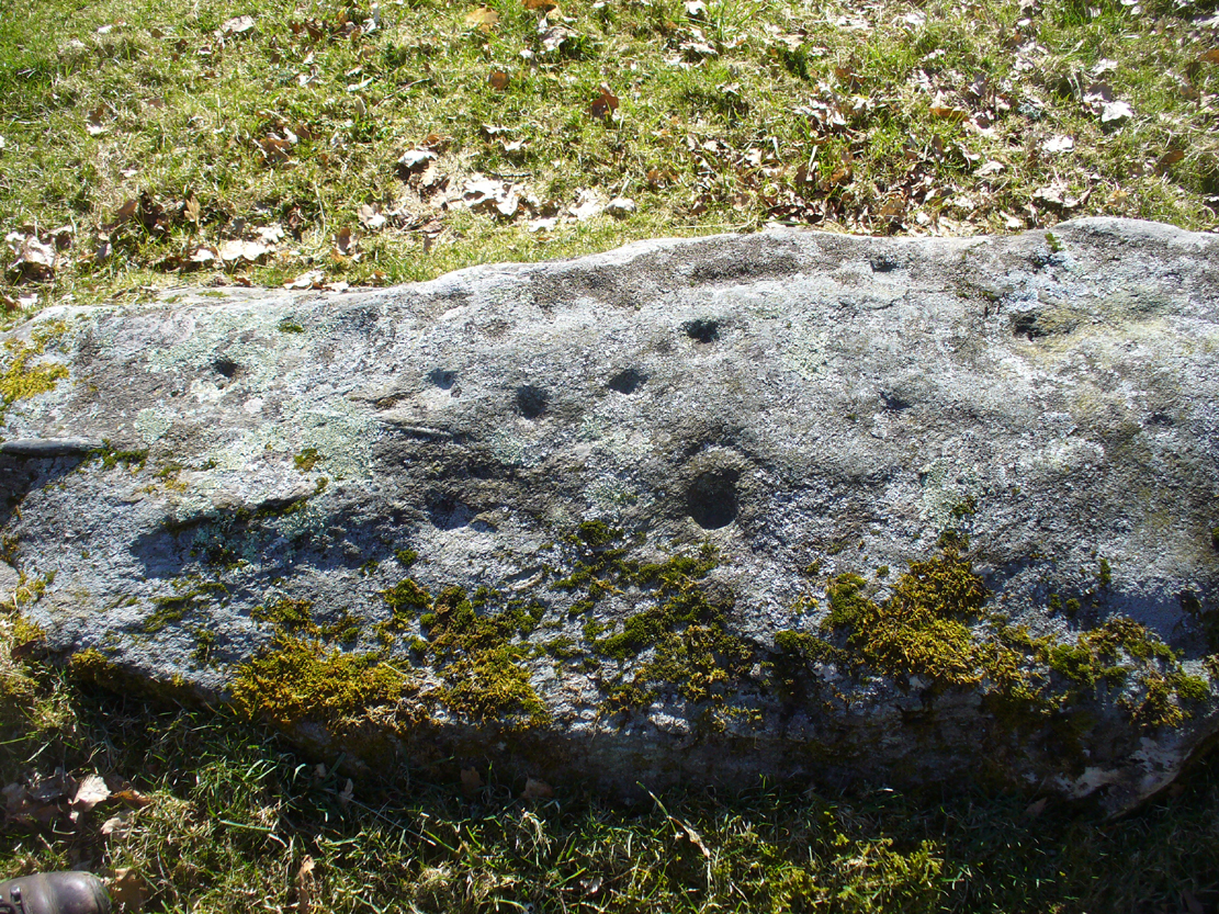
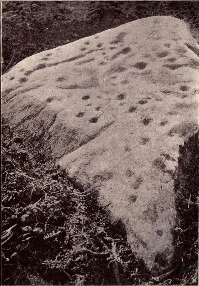
Carving 173, looking S
In my 1982 notebook I described this as “a very well-preserved cup-and-ring stone, with two cup-and-rings and seven other cup-marks. There seems to be faint remains of other lines carved by some of the cups.” And the description is as apt today as it was back then – though neither of the surrounding ‘rings’ are complete. However, as the photos here indicate, adjacent to the main cup-and-ring near the centre of the stone another incomplete cup-and-ring is evident, emerging from the natural crack that runs across it. In the subsequent surveys of Hedges (1986) and Boughey & Vickerman (2003) they somehow only saw one cup-and-ring on this rock. Easily done I suppose! In certain light there’s what may have been an attempted second surrounding ring starting on one of the cups…but I’ll leave that for a later date…
CR-173 (after Hedges)Slippery when wet!
There may also have been intent to carve another ring around one of the other cups on the northern half of the stone. This possible fourth ring and its position on the stone potentiates solar symbolism (not summat I’m keen on, tbh), which fits into the position and nature of several other cup-and-rings in this region and which I’ll expand on and highlight a little later on. It is important to remember that this petroglyph and its nearby relatives were once accompanied by a series of tumuli, or prehistoric burial mounds: a feature that is not uncommon in this part of the world. Well worth having a look at!
References:
Bennett, Paul, Megalithic Ramblings between Ilkley and Baildon, unpublished: Shipley 1982.
Boughey, Keith & Vickerman, E.A., Prehistoric Rock Art of the West Riding, WYAS: Wakefield 2003.
Hedges, John (ed.), The Carved Rocks on Rombalds Moor, WYMCC: Wakefield 1986.
Morris, Ronald W.B., “The Prehistoric Rock Art of Great Britain: A Survey of All Sites Bearing Motifs more Complex than Simple Cup-marks,” in Proceedings of the Prehistoric Society, volume 55, 1989.
From Baildon, take the road up onto the moors, turning left to go round Baildon Hill, then park-up at the small car-park on the brow of the hill at the edge of the golf course. Cross the road and take the well-trod footpath diagonally right, heading onto Baildon Moor. Walk along here for 300 yards and notice the large stone just to your right. You can’t really miss it!
Archaeology & History
Listed without real comment in several surveys, this large sloping rock that looks over the north and western landscapes of Rombald’s Moor and beyond, has several simple cup-markings on its surface, one with a faded ring around it. In more recent centuries, someone began to add their own etching onto the stone but, thankfully, stopped before defacing the ancient markings. I noted this carving in one of my early notebooks, saying only that it “lacked the central design found in others from this region,” being little more than a (seemingly) disorganized array of several marks.
Hedges 1986 drawingCups & faded ring
A greater number of other carved stones scatter the grassy flatlands west and south of here, some of which are found in association with prehistoric cairns and lines of walling; but no such immediate relationship is apparent with this particular stone.
References:
Bennett, Paul, Of Cups and Rings and Things, unpublished: Shipley 1981.
Bennett, Paul, Megalithic Ramblings between Ilkley and Baildon, unpublished: Shipley 1982.
Boughey, Keith & Vickerman, E.A., Prehistoric Rock Art of the West Riding, WYAS: Wakefield 2003.
Hedges, John (ed.), The Carved Rocks on Rombalds Moor, WYMCC: Wakefield 1986.
Morris, Ronald W.B., “The Prehistoric Rock Art of Great Britain: A Survey of All Sites Bearing Motifs more Complex than Simple Cup-marks,” in Proceedings of the Prehistoric Society, volume 55, 1989.
This fascinating looking carving (in my personal Top 10 of all-time favourites cup-and-rings in the UK!) was unfortunately destroyed sometime between 1918 and 1920. A huge pity, as the design on the rock is almost unique in its ‘linear’ system of cups running a considerable length across the surface of the stone (like the similar design found at Old Bewick in Northumberland).
Wilson’s 1851 drawing of the Witches’ StoneSimpson’s 1866 drawing of the Witches Stone
Shown first of all on Kirkwood’s Environs of Edinburgh map in 1817 (above), this legendary rock was found amidst a cluster of other cup-and-ring stones at Tormain (some are still there) and was initially said by Daniel Wilson (1851) to have been the giant capstone of a cromlech that once stood here, but whose structure had fallen away. This idea is implied in the earliest drawing we have of the stone in Wilson’s magnum opus (above); Sir J.Y. Simpson (1867) gave us a similar impression with his drawing a few years later. But upon visiting the Witches Stone just as his book was going to the press, Mr Wilson visited the site and proclaimed that he “altogether doubted if they are the remains of a cromlech”, and what rested here were more probably just fascinating geological remains, with even more fascinating carvings on top!
In the years that followed Wilson’s initial description, the Witches Stone was visited and described by a number of eager antiquarians. Simpson (1867) gave us a quite revealing account, telling:
“On the farm of Bonnington, about a mile beyond the village of Ratho…are the remains of ‘this partially ruined cromlech’…with the capstones partially displaced, as if it had slid backwards upon the oblique plane of the huge stones or stone which still supports it. Two or three large blocks lie in front of the present props. Its site occupies a most commanding view of the valley of the Almond, and of the country and hills beyond. The large capstone is a block of secondary basalt or whinstone, about twelve feet long, ten in breadth and two in thickness. Its upper surface has sculptured along its median line a long row of some twenty-two cup-cuttings; and two more cup-cuttings are placed laterally: one, half a foot to the left of the central row and at its base; the other, two feet to the right of the tenth central cup and near the edge of the block. The largest of the cups are about three inches in diameter and half an inch in depth; but most of them are smaller and shallower than this…”
A few years later another early petroglyph authority, J. Romilly Allen (1882), visited the Witches Stone and found “an Ordnance bench mark (had been) cut on the stone itself”! He then continued with his own description of this once-important megalithic site:
“The Witch’s Stone is a natural boulder of whinstone, rounded and smoothed by glacial action, whoso upper surface slopes at an angle of about 35° with the horizon. The length of the sloping face is 8 feet and at the top is a flat place 2 feet wide. The breadth of the stone is 11 feet 3 inches at the upper end, and 4 feet at the lower end. The thickness varies from 2 to 3 feet. The highest part of the stone is 6 feet 6 inches above the ground, and the lowest 1 foot 6 inches. It rests on what has originally been a portion of the same boulder, but is now a mass of whinstone broken up into several fragments, which serve as supports to prop up the stone above. Viewed from the north side the whole presents the appearance of a cromlech, the upper stone forming the cap, and the disintegrated portion below the supports. This notion, however, will be clearly seen to be erroneous on looking at it from the opposite side, as shown on the accompanying sketch…where the crack separating the two portions of the boulder is very apparent… The sculpturings consist of twenty-four cups varying in diameter from 1½ to 3 inches. Twenty-two of these cups are arranged in an approximately straight line along the sloping face of the stone, and divide it into two almost equal parts. The two remaining cups lie, one 7½ inches to the left of the lowest cup of the central row, and the other 2 feet 3 inches to the right of the ninth cup up the stone… The field in which the Witch’s Stone is situated is called “Knock-about.” The sloping face of the stone has been much polished by the practice of people climbing on to the top and sliding down. Some of the cups are almost obliterated in consequence. The stone forms a very prominent feature in the view, and must always have attracted attention from its peculiar shape.”
Some twenty years after Allen, the megalithomaniac Fred Coles (1903) came and checked the Witches Stone out for himself and, as happens, had a few additional things to say about the place:
“Although this huge boulder and its cup-marks have been more than once figured and described, I found, on a close examination of the broad surface of the Stone, that none of the illustrations showed the cup-marks in their exact relation to each other, nor in their true relation to the contour of the Stone. The drawing shown above…was made after a careful measurement by triangulation of the Stone; and it is claimed to be the first that shows that the cups, two and twenty in number, are not disposed in one continuous line, but that thirteen follow each other from the high south edge of the stone for a distance of exactly 6 feet, and nine others lie a few inches to the west, occupying a space 3 feet long of the overcurving edge of the north end. It is further shown that, at a point 2 feet 3 inches west of the ninth cup-mark, there is another one quite as large as the largest in the rows near the middle of the Stone. The south edge (A B) has slipped a little down from its original height, the boulder being frost-split horizontally; its height there above ground is 8 feet. The northern and narrower end is about 2 feet above ground, and does not touch the ground, as it rests upon its lower portion, beyond which it projects a few inches. The cup-marks run due north.”
Fred Coles 1903 drawing
If the Witches Stone was in fact a natural outcrop stone and not a cromlech, this very last point telling that “the cup-marks run due north” probably had much greater importance than a mere compass-bearing to the people who etched this carving. For in pre-christian religious structures across the northern hemisphere, north is commonly representative of death and the land of the gods. In magickal rites “it is the place of greatest symbolic darkness,” as neither sun nor moon ever rise or set there. Additionally, north is the place where, in shamanic traditions, the heavens are tied to the Earth: the cosmic axis itself that links heaven, Earth and underworld. In early neolithic traditions this mythic structure was probably endemic. Whether its magickal relevance was intended here, at this stone, we will probably never know…
Folklore
Folklore tells that the Witches Stone was one of the sites used in magickal rites by the Scottish occultist, Michael Scot. J.R. Allen’s (1882) description of “the sloping face of the stone has been much polished by the practice of people climbing on to the top and sliding down,” may relate to folk memory of fertility rites once practiced here, as found at similarly carved rocks in the UK and across the world.
McLean, Adam, The Standing Stones of the Lothians, Megalithic Research Publications: Edinburgh no date (c.1978).
Morris, Ronald W.B., The Prehistoric Rock Art of Southern Scotland, BAR: Oxford 1981.
Royal Commission on the Ancient & Historical Monuments of Scotland, Inventory of Monuments and Constructions in the Counties of Midlothian and West Lothian, HMSO: Edinburgh 1929.
Simpson, James, Archaic Sculpturings of Cups, Circles, etc., Upon Stones and Rocks in Scotland, England and other Countries, Edmonston & Douglas: Edinburgh 1867.
Take the road up alongside and past Shipley Glen, taking the turn to go to Crook Farm caravan site. Go right to the very end of the car-park, then walk up the footpath through the trees on your left. Keep going uphill about 100 yards by the field-wall until the land begins to level out – and shortly before the first gate into the field (on your right) keep your eyes peeled for the triangular stone in the ground, barely 10 yards away from the walling. Alternatively, from the entrance into the Dobrudden caravan park walk to the far-end of the level area in front of the little cafe and walk along the footpath that crosses the grassland to the walling nearly 300 yards away (south). Follow the wall down below the gate and zigzag about. You’re damn close!
Archaeology & History
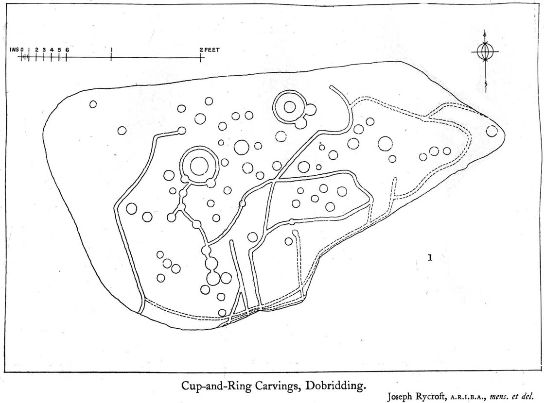
Crook Farm north carving
For some reason this has always been one of my favourite cup-and-ring stones on Baildon Moor and it’s well worth checking out if you visit the area! It was rediscovered by the Bradford historian W.E. Preston, who photographed the carving around 1912. Shortly afterwards he took fellow historians Joseph Rycroft and W. Paley Baildon to see this (and others he’d located) and subsequently both a drawing and Mr Preston’s photo of the site was included in Mr Baildon’s (1913) magnum opus the following year.
As you can see from the relative photos—with literally 100 years between them—erosion hasn’t taken too much toll and this neolithic or Bronze Age carving remains in very good condition.
Rycroft’s early drawingPreston’s 1912 photo
Covered with upwards of fifty cup-markings, there are also two cup-and-rings and numerous carved lines meandering around and enclosing some of the many cups. One cup-mark was cut into the narrow end or ‘nose’ of the stone.
It’s a fascinating design, with another ‘Cassiopeia’ cluster of cups in one section, beloved of archaeoastronomers who explore these stones. Mr Rycroft’s drawing of the design (left) is perhaps the best one, to date.
Along this same ridge there are remains of other prehistoric sites, more cup-and-rings, remains of prehistoric walling and what may be a small cairn circle (to be described later).
References:
Baildon, W. Paley, Baildon and the Baildons – parts 1-15, Adelphi: London 1913-1926.
Bennett, Paul, Of Cups and Rings and Things, unpublished: Shipley 1981.
Bennett, Paul, Megalithic Ramblings between Ilkley and Baildon, unpublished: Shipley 1982.
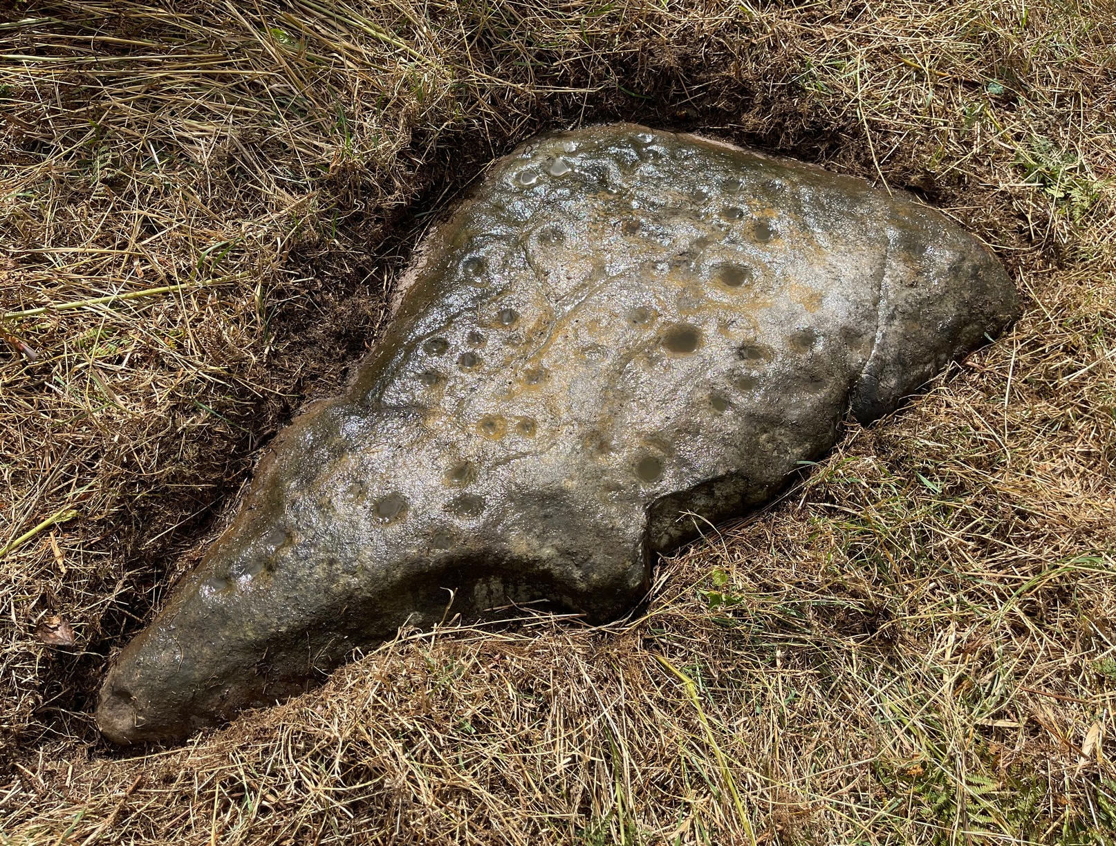
Whether you come via Shipley Glen or Baildon, head for the Dobrudden caravan park on the western edge of Baildon Hill. As you get to the entrance of the caravan site, turn right and walk along the outer walling of the caravan site, up and around for less than 100 yards. Keep your eyes peeled for the upright stone against the outer walling (the famous Dobrudden Cup-and-Ring Stone), and just 10 yards away, laid flat in the grasses, you’ll see this small cup-and-ring stone!
Archaeology & History
Found just a few yards from the well-known Dobrudden Carving that stands up against the wall, this small flat level stone, slowly again being encroached by Earth’s skin, is found on the edge of the High Plain, whereon the usual conjunction of prehistoric tombs and cup-and-rings is found once again. Whether this carving ever had its own cairn or funerary monument is now hard to say for sure; and the excessive erosion of modern humans is slowly eradicating the landscape all round here.
Jackson’s 1956 drawingHedges 1986 drawing
Consisting of two cup-and-rings (with very deep cupmarks in the centres), there are also what seem like artificially carved lines or grooves running across the stone. It was first described in a short article in the Cartwright Hall Archaeology Group Bulletin (Jackson 1956)*, found lying “in the path alongside the north wall of the Dobrudden Farm enclosure.” It seems like stone may have been covered over until some local work on Dobrudden unearthed it in the latter half of the 20th century. There’s also an intriguing note told by a local man called Jack Taylor, which Jackson narrated, saying how he,
“always held the opinion that the rings were not contemporary with the cups, and went so far as to suggest that they had been carved within living memory by someone anxious to ‘improve’ the boulder.”
This might be the case, as there is another carving not far away near the top of Baildon Hill that certainly seems to have been done in the 20th century. And one of the two surrounding rings on this stone does appear to have a more recent look to it than the other. However, we must consider that the covering soil has kept the carved rings in such good condition. (There are examples of petroglyphs throughout the world where certain carved elements were added at later times by countless aboriginal tribes.)
Close-up of cup-&-ringsDobrudden carving 150
Like all of these carvings, to get an accurate picture of the true original we must visit them in all weathers all through the year, to see how differing seasons express the petroglyph. For we can see on some images we have of this carving a number of features that aren’t on the drawings of either Jackson (1956) or Hedges (1986): whether the rings surrounding the cups are ancient or not, there is a definite carved line nearly linking them together; and at least one faint line stretches down from one of the rings. We need to visit the carving again to see if such features show up with greater clarity when lighting conditions are better.
References:
Baildon, W. Paley, Baildon and the Baildons – parts 1-15, Adelphi: London 1913-1926.
Bennett, Paul, Megalithic Ramblings between Ilkley and Baildon, unpublished: Shipley 1982.
Boughey, Keith & Vickerman, E.A., Prehistoric Rock Art of the West Riding, WYAS: Leeds 2003.
Hedges, John, The Carved Rocks on Rombald’s Moor, WYMCC: Wakefield 1986.
Jackson, Sidney, “Another Cup-and-Ring Boulder,” in Bradford Cartwright Hall Archaeology Group Bulletin, 1:13, 1956.
* Boughey & Vickerman (2003) cited W. P. Baildon’s magnum opus (1913) as the first to describe this stone, but this is untrue (there’s certainly no mention nor illustration of it in my editions of the Baildon volumes).
Whether you come via Shipley Glen or Baildon, head for the Dobrudden caravan park on the western edge of Baildon Hill. As you get to the entrance of the caravan site, walk down (left) the footpath outside the park itself, looking across the grasslands, left, to the tree-lined wall a coupla hundred yards away. Head for that. Then go through the gate into the field where you’ll see a denuded line of walling, with what looks like some standing stones along it. That’s where you need to be!
Archaeology & History
First noticed on February 12, 2012, this simple cup-marked stone is another one that’s probably only of interest to the purists amongst you. Found below the southern end of Baildon Hill, due west of the lost Hope Farm cup-and-ring stone, the cup-markings here are on the north-face of an upright stone in an old wall. It’s obvious that this stone was once earthfast, when the carving faced the zenith or night sky, and has been cut in half and turned 90° making the cups more difficult to notice; and very obviously the rock was originally close to its present position in the walling.
Primary cupmark, right-side of stoneClose-up of cup/s
Found in an area rich in cup-and-ring stones, there’s just one singular cupmark that’s obvious on this stone; but as we looked back and forth, feeling the stone with our fingers, it seemed there may be a couple of others on the rock. We need to come back here again in better lighting conditions, as opposed to the old grey day She gave us yesterday, and see if the others are real or simple geological marks.
Cup-and-Ring Stone: OS Grid Reference – SY 6800 8601
Also Known as:
Winterborne Came 18b Carving (Grinsell)
Archaeology & History
Charles Warne’s 1848 drawing of the old tumulus
On January 27, 1848, the great Dorsetshire antiquarian Charles Warne sent a letter to the British Archaeological Association about a series of three large tumuli he’d explored south of Dorchester in Dorset, within which he’d found some fascinating remains. And in what he called “the last of these mighty mounds (and well do they merit the appellation from their vastness),” which “measured rather more than ninety feet in diameter, and sixteen feet in height,” the most intriguing remains emerged. In the middle of what L.V. Grinsell (1959) catalogued as the Winterborne Came 18b tumulus, Mr Warne told:
“About the centre, at a depth of some three feet from the surface, was found lying flat a rough unhewn stone, with a series of concentric circles incised; this, on being removed, was seen to have covered a mass of flints from six to seven feet in thickness, which being also removed we came to another unhewn irregular stone, with similar circles inscribed, and as in the preceding case, covering another cairn of flints, in quantity about the same as beneath the first stone.”
“…It will be seen that the most singular feature connected with this tumulus, is that of the incised stones: examples of which I am not aware have before been met with in like situations. It may be as well to forego any attempt at an elucidation, which must be purely hypothetical; but it seems more reasonable to believe that they bore some mystic reference, rather than that they were the unmeaning amusement of some Celtic idler.”
One of 2 carved stones found in the tumulus
Sir James Simpson (1867) described these carved stones in his 19th century magnum opus, giving an early illustration of one of them, as shown here. You’ll note that the carving is devoid of any central ‘cup’ as commonly found, consisting simply of a mere series of concentric rings.
If anyone knows the whereabouts of this and its companion stone today, it would be good to see them. Are they kept in some local museum?
References:
Grinsell, Leslie V., Dorset Barrows, Dorset Natural History & Archaeological Society 1959.
Royal Commission on Historical Monuments (England), An Inventory of Historical Monuments in the County of Dorset – Volume 2: South-East, HMSO: London 1970.
Simpson, James, Archaic Sculpturings of Cups, Circles, etc., Upon Stones and Rocks in Scotland, England and other Countries, Edmonston & Douglas: Edinburgh 1867.
Warne, Charles, “Removal of Three of the Large Tumuli on the Came Estate, near Dorchester,” in Journal of the British Archaeological Association, volume 3, 1848.
Follow the same directions for the Croft Moraig stone Circle. Then check out the elongated stone lying in the grass on the southern edge of the circle. It’s not that hard to find!
Archaeology & History
Nearly 13 yards (11.75m) south of the faded Croft Moraig 2 carving, this cup-and-ring stone on the SSW edge of Croft Moraig is one of at least four that have been found in this megalithic ring. It has been suggested that the stone on which the carving is found once stood upright. The earliest account I’ve found of it comes from Alex Hutcheson’s (1889) essay in which he wrote:
“At the south-west side and in the line of the outer circle lies the cupmarked stone. It is a recumbent stone, and like the others in that circle lies with its larger axis in the direction of the encircling line. It measures 6 feet 6 inches long by 2 feet broad, and bears on its surface 23 cups. Two of these are connected by straight channels. The largest cup is 2 inches in ‘diameter and f inch deep. Two of the cups are encircled, each with a concentric ring. None of the other stones exhibit any cups or other artificial markings.”
Cup-marks pointed outFred Coles 1910 drawing
…Although other cup-marks have subsequently been found on other stones within the circle. Consistent with the location of cup-and-ring marks elsewhere in the country, Hutcheson found the carved rock to be just in front of “a longish low mound of small stones, like an elongated cairn, which might yield something if it were to be searched.” Very little of this cairn remains today.
When Fred Coles (1910) came to explore Croft Moraig about 20 years later, he could only discern 19 cups on the stone, most of them the same size, “only two of which differ much in diameter and depth from the rest.” The cup-and-ring that Hutcheson described and the other missing cups had been overgrown by the grasses, Coles said. When Sonia Yellowlees described the carving in 2004, she said that 21 cups were visible, “one of which is surrounded by a single ring”—which you can clearly see in the photos below.
Carving 1 with cup-and-ringClose-up of design
When archaeologist Evan Hadingham (1974) looked at this site, he found deposits of quartz here and thought that their presence may have been relevant to the placement of the carving, noting how such a relationship is found at other circles in Scotland. In more recent years, rock art students Richard Bradley and others have found similar quartz deposits in or around some petroglyphs a few miles from here; as have fellow students Jones, Freedman and o’ Connor (2011) at some of the rock art around Kilmartin. In my own explorations of the carvings near Stag Cottage, hundreds of quartz chippings were found that had been pecked into the cups and rings.
References:
Burl, Aubrey, Rings of Stone, Frances Lincoln: London 1979.
From Ilkley, take the Wells Road heading towards White Wells, bending round the bottom of the moor, making sure you keep left along Westwood Drive (not further up the moor along the Keighley Road). Keep along Westwood Drive – it becomes Panorama Drive after a while – until you come to the small copse of woods on your right, a short distance before the end of the road. Go along the footpath by the wall at the side of the house, bending into the woods after 10 yards. Another 10 yards on, you’re near the edge a drop down the slope, where a number of large rocks are seen. Look around!
Archaeology & History
Carving 236 (after Boughey & Vickerman)
A singular cup-and-ring carving can be seen, rather faintly, near the nose-end of this large mossy stone, close to the edge of the ridge. It is one of a small cluster of carvings that remain in this small bit of woodland. Other highly ornate carvings could once be seen in the same stretch of woodland — where the rich houses now stand — amidst remains of a prehistoric enclosure or settlement of some sort. All remains of this settlement have been destroyed, which is a pity as it may have given us helpful information about the nature of this carving and its nearby relatives.
References:
Bennett, Paul, The Panorama Stones, Ilkley, TNA: Yorkshire 2012.
Boughey, Keith & Vickerman, E.A., Prehistoric Rock Art of the West Riding, WYAS: Wakefield 2003.
Hedges, John (ed.), The Carved Rocks on Rombalds Moor, WYMCC: Wakefield 1986.
From the B6265 valley road between Bingley and Keighley, just near Riddlesden Hall, take the road up and over the canal into Riddlesden, bearing left up past West Riddlesden Hall and up Banks Lane. As you reach the T-junction at the top, where you hit the Silsden Road that goes round the moors, park up. Turn left and walk along the Silsden Road, counting the field on your left, moorland-side. At the fourth, go through the gate uphill, keeping to the walls on the right and going through the second gate up. Walk straight on for nearly 130 yards (119m) where you’ll see this group of three earthfast rocks right next to each other.
Archaeology & History
‘Ring of cups’ motif
Not included in any pervious archaeological survey, this is a fine cup-marked stone with at least 25 cups etched into this average-sized rock, halfway up this field of stones. When this carving was rediscovered on Friday, 6 January, 2012, it was noticed that a couple of cup-marks were peeking out from the edge of the grasses covering the rock — and so a careful and gradual uncovering of the rock itself was slowly exposed and see if the initial suspicions of an authentic carving were correct. Thankfully it turned out right!
When first spotting this, I undercovered more beneath the soil, although it’s not clear how much of this stone is covered in carvings, as the Earth has grown considerably over the top of it. There is also what seems to be a geological curiosity on the eastern section of the stone; whereby some apparent ‘cups’ seem to have been created by natural process. However, these have been added to by human hands at a distant time, long ago. The cup-marks themselves vary in size, from small ones barely an inch across, to larger ones measuring some 3-inches in diameter; and oddly, the cups seem to get larger the further west you travel across the stone! More research is needed at this site to ascertain the a more complete image of the petroglyph.


")
")
sm")
")


")