Ratten Clough Cross, Emmott Moor, Lancashire

Cross Base:  OS Grid Reference – SD 93997 39746

Getting Here

Ratten Clough Cross stone

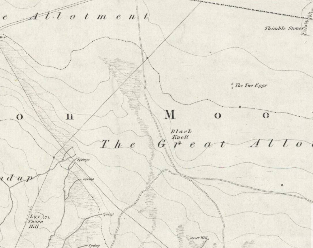
Follow the directions to reach the Herder’s Cross, not far away.  Standing on the Herder’s Cross stone, look across the fields to the north (away from the farmhouse on the hill below) and you’ll see a nice-looking stream a coupla hundred yards ahead of you.  Crossing this stream you see the large boulder, which you can see clearly if you’re stood on the Herder’s Cross.  That’s where you’re heading!

Archaeology & History

A curious entry inasmuch as I’ve found no other references to the place.  It’s an obvious cross-base, albeit very worn, cut onto the top of this large boulder, as you can see in the photo.  What may be a singular cup-marking (if you’re a New-ager, or work for English Heritage that is!) is on the western side of the rock — but without additional markings on the rock, this has gotta be questionable.

Dodgy cup-marking on top!
Shallow cross-base

The cut ‘square’ measures eight-inches both sides, but it seems that the cutting on the north-eastern sides of the base was never finished.  The depth of the cross-base is also very shallow, only an inch deep.  There seems to be a distinct possibility that this particular stone was initially chosen as a wayside cross marker, then for some reason perhaps moved to the position of the Herder’s Cross in the fields 420 yards (383m) to the south of here.

Clifford Byrne (1974) suggested that the pathway hereby was an ancient routeway that led towards the Emmot Holy Well, three-quarters of a half-mile down the hillside from here.  Any further info or thoughts on this side would be most welcome.

References:

  1. Byrne, Clifford, A Survey of the Wayside Crosses in North East Lancashire, unpublished manuscript, 1974.

© Paul Bennett, The Northern Antiquarian


Banbury Cross, Oxfordshire

Cross:  OS Grid Reference – SP 45323 40397

Also Known as:

  1. High Cross
  2. Market Cross

Archaeology & History

Banbury Cross (after Ronald Goodearl, 1973)

The original stone monolith that stood here has long since been destroyed (by christians arguing amongst themselves) and the ornate edifice that we see today was erected in 1859 to commemorate the marriage of Queen Victoria’s eldest daughter, Victoria Adelaide Mary Louisa, to Friedrich Wilhelm of Prussia.  Standing more than 52 feet tall, it is of a neo-Gothic design and is one of the tallest crosses in the country.  Originally there were going to be six carved statues cut into the niches of the cross, but this was later reduced to three.

First mentioned in place-name records from 1478, the original stone cross was itself very prominent, rising some 20 feet tall and sitting upon a square base of eight steps.  It was described by John Leland in his Itinerary when he visited the town sometime between 1535 and 1545, who said:

“At the west part of the street…is a large area, having a goodly cross with many degrees (steps) about it.  In this area is kept every Thursday a very celebrated market.”

The old cross was also a site where public notices and proclamations were dispensed to local people and seems to have been an old meeting place.  Whether it had a prehistoric predecessor isn’t known.

Folklore

The nursery rhyme we’ve all recited when we were kids and growing-up, has much of its origins around this ornate edifice and in the 20th century was thought to have its origins in pre-christian practices hereby, but this is questionable.  The rhyme, to those who don’t know it, goes:

Ride a cock-horse to Banbury Cross,
To see a fine lady upon a white horse,
With rings on her fingers and bells on her toes,
She shall have music wherever she goes.

As Kirsten Ayles (1973) told:

“This rhyme was first recorded in 1784, but it probably originated much earlier.  The Banbury Cross mentioned was destroyed at the turn of the 16th century by the Puritan inhabitants of Banbury.  It has been suggested that “bells on her toes” points to the fifteenth century, when a bell was worn on the long tapering shoe of each shoe.  It has (also) been thought that the “fine lady” was Queen Elizabeth I, or Lady Godiva.”

Another option identifying the “fine lady” in the rhyme is perhaps a member of the Fiennes family, ancestors of Lord Saye and Sele who owns nearby Broughton Castle.

References:

  1. Ayles, Kirsten, “A Short History of Nursery Rhymes,” in This England, 6:3, Autumn 1973.
  2. Gelling, Margaret, The Place-Names of Oxfordshire (2 volumes), Cambridge University Press 1954.
  3. Vallance, Aymer, Old Crosses and Lychgates, Batsford: London 1920.

Acknowledgements:

To Ronald Goodearl, for use of his 1973 photograph of the Banbury Cross.

© Paul Bennett, The Northern Antiquarian 


Annot Cross, Brierfield, Lancashire

Cross (destroyed):  OS Grid Reference – c. SD 881 353

Archaeology & History

Not included in the magnum opus of Henry Taylor (1906), the exact position of this long lost site remains unknown, as even the investigative abilities of Clifford Byrne couldn’t track it down!  It was erected in a region full of pre-christian remains and (at the time) living remnants of heathen folklore and practices between Worsthorne and Nelson.  Mr Byrne (1974) described his search for the place, saying:

“This cross is of ancient origin and no part of it now remains as far as can be ascertained by investigation, although the memory of it certainly remains, for an elderly gentleman living in the cottages of Holt Hill, Briercliffe, said instantly on being asked about he cross that he had often heard it referred to by older people when he was a boy, although he could not say exactly where in the hamlet the monolith had stood.  We are told that the cross is mentioned in a document in the year 1313 when Robert Briercliffe granted away the Sene intacks in the Holt Hill as it lay by Annot Cross on the south side.  This implies that it stood on the south side of the road (between) Thursden and Haggate, which is an old road from Burnley to Halifax…”

This would give a rough grid reference for its position around SD 881 353, but nothing appears to be there.  However, Byrne told of another intriguing bitta folklore a short distance away which may have had some relevance to the positioning of the cross.

“Down the road to Lane Bottoms, behind some bungalows, is a stone shaft in a depression in a meadow which we are told is an ancient standing stone.  Whether this is so is not easy to ascertain for the stone has apparently been used as a gatepost at some time, and further gives indication of having been utilised as a cattle rubbing post.”

Below here we find the old place-name ‘Burwains,’ which clearly indicate a site of a prehistoric burial, though nothing remains of such a place — officially at least.  Perhaps a couple of ventures in and around this area need to be done!  One final note that Byrne made related to the title of this lost cross, saying:

“The name “Annot” may be of Saxon origin, for the Saxon word annet means solitude, and this would have certainly fitted the area in ages past.”

References:

  1. Byrne, Clifford, A Survey of the Ancient Wayside Crosses in North-East Lancashire, unpublished report 1974.
  2. Taylor, Henry, The Ancient Crosses and Holy Wells of Lancashire, Sherratt & Hughes: Manchester 1906.

© Paul Bennett, The Northern Antiquarian


Salford Cross Cup-Marks, Oxfordshire

Cup-Marked Stone:  OS Grid Reference – SP 28644 28058

Getting Here

Pretty simple this one.  From Chipping Norton, head west on the A44 for a coupla miles till you hit the lovely Salford village.  The church stands out, so head for it and, as you walk towards the building, watch for the small stone cross in front of you.

Archaeology & History

Salford Cross cup-markings

This is curious.  Very curious!  We might expect to find cup-markings occasionally on some of the cross-bases or other early christian monuments in northern England and Scotland, but to find them in the heart of a small Oxfordshire village where the tradition of cup-marked stones is unknown, was something of a surprise when Tom Wilson and I (1999) found it, to say the least!  But this is what we’re looking at here.

Salford Cross remains

On the remains of an old medieval cross, whose broken shaft has seen better days,  as the photo shows — and as a personal viewing shows even clearer — there are 3 simple cup-markings etched on one side of the cross-base in Salford churchyard.   The cups certainly aint natural, but then also they don’t have the archaic looks of the prehistoric carvings from Yorkshire to Scotland.  It would be good if we had a more extensive history of the cross monument itself, perhaps saying precisely where the stones which make it up came from, but local records tell us nothing it seems.  If we could ascertain that parts of it were made up of some remains taken from some local prehistoric ‘pagan’ tomb (and a number of tombs have been found in and around this area), then some sense could be thrown upon its position here.  But until we can ascertain more about the history of the cross, the three clear cup-markings on the cross-base remain somewhat of a mystery.

Folklore

Lovers of ley lore will be intrigued to find this carved cross-base is on a very accurate ley linking the King Stone, Rollright stone circle, Little Rollright church (where a standing stone can be found in the walling just before it), the Salford Cross and the site of another cross on the hill outside the village.

References:

  1. Bennett, Paul & Wilson, Tom, The Old Stones of Rollright and District, Cockley: London 1999.

© Paul Bennett, The Northern Antiquarian


Herder’s Cross, Wycoller, Lancashire

Cross:  OS Grid Reference – SD 94057 39369

Also Known as:

  1. Herders Common Cross

Getting Here

From Laneshaw Bridge, near Colne, take the long country road that goes up above Wycoller to Stanbury and Haworth over the Yorkshire-Lancashire border.  A couple of miles uphill, there’s a parking spot with views across the moors.  Stop here.  Cross the road and walk up for about 100 yards, going thru the rickety gate on the left, and up the field (past the small disused quarry) until you see the large rock looming ahead of you, perched on its own.  That’s it!

Archaeology & History

Herders Cross stone

This is a really curious spot to me.  A large singular boulder sat on the edge of an uninhabited moorland with no real history of heathenism, nor religious practices; yet someone at sometime in the not-too-distant past saw something here that made them cut a large square hollow into the top of this stone, in which they stuck an old cross.  We came across this site a few weeks ago quite by accident, but realised that the deep hollow in the rock was an old cross base; so when I got home I checked Taylor’s (1906) magnum opus, expecting to find some info therein.  But even Taylor seemed to know nothing of this place.

A week or two later, Paul Hornby pointed me in the direction of an unpublished essay by a local chap called Clifford Byrne (1974) who’d studied some of the early christian remains in the region and who wrote the following of what he named “Herders Cross”:

“This cross, or more properly its socket, is probably one of the least known in the area.  It was shown to the writer by Mr Stanley Cookson of Trawden, who discovered the socket in passing, so to speak.  On the road to Haworth from Laneshawbridge, opposite the site of Foster’s Leap rocks, on the east side of the road, is a really huge boulder on the moor top.  In the south side is the cross socket, whilst on the north side of the rock can be made out a right-angled mark which implies that either the socket was being placed on that side in the first instance, or that two sockets were once envisaged…

“Old maps show the rock in situ with a “shaft” protruding from the top.  Some yards west a shallow pony track  bypasses the site, whilst some four or five hundred yards east a very well worn and ancient road, long unused, passes in the direction of Emmot Holy Well.  The cross may thus have been a Wayside Cross showing the way to this Holy spring which is remembered as being propitious in the cure of rheumatism.”

Cross-base socket

This may be so; but I suspect earlier, heathen remains upon the moors here to explain the curious position of both this and another cross-base some 400 yards away.  Some dubious cup-marks can be seen by the side of the stone hollow; and other dubious ones have been found on the moors above here.  There is folklore of a lost stone circle on the hills above here, and a scattering of little-known faerie lore, indicating hidden sites and lost myths.  These ingredients are more likely the reasons that Herders Cross was erected here, overlooking the countryside south and west, with the holy hill of Pendle rising in the centre of the distant landscape…

References:

  1. Byrne, Clifford, A Survey of the Wayside Crosses in North East Lancashire, unpublished 1974.
  2. Taylor, Henry, The Ancient Crosses and Holy Wells of Lancashire, Sherratt & Hughes: Manchester 1906.

© Paul Bennett, The Northern Antiquarian


Churchyard Cross, Prestbury, Cheshire

Cross: OS Grid Reference – SJ 9007 7692

Archaeology & History

Prestbury Cross (by R.A. Riseley)

Many churches strive to find evidence in the greater antiquity of their foundations than the industrial age; and even those whose origins are medieval hope to find much older roots.  Such is the case with this Norman church of St. Peter, where just such an antiquity was found in the middle of the 19th century, embedded in the old walling where it had been encased many centuries before.  Thought to have been carved around the 8th century, the design on the stone typifies much ‘Celtic’ art, as it tends to be called, such as are found all over northern England.  As we can see here, the main feature is a series of curved and interlocking lines covering most of the rock face (sadly, no swastika occurs on this stone, but it’s common on many others of this period).  The old vicar of the church — Harold Rogers — takes up the story:

“About the year 1841, when part of the chancel work was taken down, some fragments of curiously ornamented sandstone were discovered embedded in the masonry.  They were carefully removed, put together, and placed in the churchyard where, protected from injury by a glass case, they may now be seen.  The carved ornamentation on this ancient relic was probably executed about the 8th century, and it is conjectured that the stone formed part of a cross placed there by some early Saxon converts…to commemorate the spot where the gospel was first preached in this locality.”

A brass inscription attached to the encased carved stone informs the visitor the same information.  The proximity of this early carved stone to the River Bollin and, very probably, an ancient ford crossing, implies the waters here were held as sacred in ancient days and hence the supplanting of the ornate carved cross at this position in the landscape.

References:

  1. Rogers, Harold W., Prestbury and its Ancient Church, Arthur Clownes: Macclesfield n.d. (c.1960)

© Paul Bennett, The Northern Antiquarian


Market Cross, Glastonbury, Somerset

Cross:  OS Grid Reference – ST 49875 38924

Also Known as:

  1. Glastonbury Cross

Archaeology & History

The present day Market Cross that stands in Glastonbury’s High Street, ornate though it may look, replaced a much earlier and more memorable monument.  The one we see today, said Charles Pooley (1877),

“at the junction of the four streets, was erected in 1846, after the design of B. Ferrey, Esq., at the instance and the cost of a private individual.  It is a Gothic pinnacled structure of a simple type, with no pretensions to elaborate architectural display.”

The ancient Market Cross
The new Market Cross

A very poor substitute for the cross that stood in its place in earlier centuries, from all accounts.  Before the modern spire was erected, an earlier, larger and more ornate structure — that seems to have been first described in John Leland’s classic Itinerary (1744 ) in the middle of the 18th century, simply as “the Market Crosse in the West Ende” — was the meeting point for the tradesmen and villagers of Glastonbury.  Although Rahtz & Watts (2003) followed Leland in giving only passing mention to this once ornate structure, thankfully a number of earlier antiquarians gave the old cross a bit more literary attention.  Mr Pooley (1877) again informs us:

“Warner, who was in Glastonbury in 1799, says, “In my way to the Abbey, I passed the Market Cross, and old polygonal structure, its apex crowned with a little naked figure, bearing strong marks, in its position and employment of that grossness of taste, in which the sculptors of the 15th century so frequently indulged.”

Other writers weren’t as puritanical in their descriptions.  In John Britton’s (1807) tour of the architectural curiosities of the region he remarked:

“Though a large and extremely curious structure…it is scarcely noticed in the topographical annals of the county; its history is, therefore, perhaps entirely lost.  Since the drawing was taken in 1802, the Cross had been suffered gradually to fall into ruins, part of the centre column then only standing.”  He continued: “There is something peculiarly unique in the shape and ornament of this building.  A large column in the centre, running through the roof, and terminating with a naked figure, clustered columns at each angle with odd capitals, bases, etc., and gables with pinnacles of unusual shape, all unite to constitute this one of the eccentricities of ancient building.  From the time of the Norman Conquest to the Dissolution of the Engilsh Monasteries, the varied and progressive styles of architecture are satisfactorily defined, and a very general uniformity prevails in all the buildings of particular eras; but the specimen before us differs from anything that we have yet met… In the year 1802 there was a mutilated inscription on it, with the year 1604, but we cannot say that this date refers to the time of its building.  There were also some armorial bearings carved on different parts of it.  Among these were the arms (a cross between two cups) of Richard Beere, the last Abbot but one of Glastonbury.  The presence of the canting device of Richard Beere would probably determine the date of its erection.”

Mr Pooley’s (1877) own description of the old cross told that,

“It was built of hewn stone on an octagonal plan, having clustered pillars ranged round a central column supporting the roof.  Three steps, the lower one benched, surrounded the base of the shaft, for the convenience of the market people.  The gables were terminated by moulded pinnacles, and the central shaft, which rose above the roof, was surmounted by a statue.  Adjoining the cross was an ancient conduit, having a vaulted roof, and supplied with water from a reservoir at the uper part of town.  These structures being in want of repair…it was determined to pull them down, which was done accordingly in the year 1808.”

So the next time anyone visits Glastonbury’s tall spired cross in the middle of the town, remember its old and much more ornate predecessor. Perhaps some of you arty-types down there could do a replica of the old thing with its naked figurines and resurrect it from its forgotten past…

References:

  1. Britton, John, The Architectural Antiquities of Great Britain, Longman, Hurse: London 1807.
  2. Leland, John, The Itinerary, James Fletcher: Oxford 1744.
  3. Michell, John, New Light on the Ancient Mystery of Glastonbury, Gothic Image: Glastonbury 1990.
  4. Pooley, Charles, The Old Stone Crosses of Somerset, Longmans, Green & Co.: London 1877.
  5. Rahtz, Philip & Watts, Lorna, Glastonbury: Myth and Archaeology, Tempus: Stroud 2003.

© Paul Bennett, The Northern Antiquarian


Black Knoll Cross, Morton Moor, West Yorkshire

Cross:  OS Grid Reference – SE 1034 4465

Also Known as:

  1. Black Knowle Cross

Getting Here

Black Knoll on 1851 map

Get up to the Twin Towers right at the top of Ilkley Moor (Whetstone Gate), then walk east along the footpath, past the towers for about another 100 yards, looking out on the other side of the wall until it meets with some other walling running downhill onto Morton Moor.  Follow this walling into the heather for a few hundred yards.  Where it starts dropping down the slope towards the small valley, stop!  From here, follow the ridge of moorland along to your left (east) and keep going till you’re looking down into the little valley proper.  Along the top of this ridge if you keep your eyes peeled, you’ll find the stone cross base sitting alone, quietly…

Archaeology & History

This old relic, way off any path in the middle of the moor, has little said of it.  Whilst its base is still visible — standing on a geological prominence and fault line — and appears to taken the position of an older standing stone, christianised centuries ago, the site is but a shadow of its former self.  When standing upright may centuries back, the “cross” was visible from many directions. We discovered this for ourselves about 20 years back, when Graeme Chappell and I sought for and located this all-but-forgotten monument.  When we found the stone base, what seemed like the old stone cross lay by its side, so we repositioned it back into position on July 15, 1991.  However, in the intervening years some vandal has been up there and knocked it out of position, seemingly pushing it downhill somewhere.  When we visited the remains of the cross-base yesterday (i.e., Dave, Michala Potts and I) this could no longer be located.  A few feet in front of the base however, was another piece of worked masonry which, it would seem, may have once been part of the same monument.

Cross-base, looking north
Close-up of cross-base

Years ago, after Graeme and I had resurrected the “cross” onto its base, I went to visit the Bradup stone circle a few weeks later and found, to my surprise, the upright stone in position right on the skyline a mile to the northeast, standing out like a sore thumb!  This obviously explained its curious position, seemingly in the middle of nowhere upon a little hill.  This old cross, it would seem, was stuck here to replace the siting of what seems like a chunky 3½-foot long standing stone, lying prostrate in the heather about 10 yards west of the cross base.

Stuart Feather (1960) seems to be the only fella I can find who described this lost relic, thinking it may have had some relationship with a lost road that passed in the valley below here, as evidenced by the old milestone which Gyrus and I resurrected more than 10 years back.  Thankfully (amazingly!) it still stands in situ!

If you aint really into old stone crosses, I’d still recommended having a wander over to this spot, if only for the excellent views and quietude; and…if you’re the wandering type, there are some other, previously undiscovered monuments not too far away, awaiting description…

References:

  1. Bennett, Paul, The Old Stones of Elmet, Capall Bann: Chieveley 2001.
  2. Feather, Stewart, “A Cross Base on Rombald’s Moor,” in Bradford Antiquary, May 1960.
  3. Feather, Stewart, “Crosses near Keighley,” in Cartwright Hall Archaeology Group Bulletin 5:6, 1960.

© Paul BennettThe Northern Antiquarian


Thursday Market Cross, York, North Yorkshire

Cross (destroyed):  OS Grid Reference – SE 603 519

Archaeology & History

Early drawing of York’s Market Cross

This old cross was demolished long since, but I think it’s important to rejunevate a memory of its existence back into our times.  Little has been written about the site as it was destroyed more than 200 years ago and images of the edifice are rare indeed!  It was found near the modern centre of the city and although this ornate-looking thirty-foot tall cross was obviously impressive, an even earlier upright stone stood here in the 13th and 14th century.  But this new carved monument took precedence over its older and lesser upright.  First described — I think! — by Thomas Gent (1730), he told us that,

“The old cross stood towards the Kennel, against the middle of the market.  The lower part was an octagon, had an ascent of six high steps, covered with Tyles for Butchers, higher up with nitches, in which had been effigies and a small pillar above with four Dials and over them a Fane.”

A few years later when Francis Drake (1788) described the same monument, he added very few extra details; though told us it had five steps and not six — but this seems to have been an error on his behalf.  In C.B. Knight’s (1944) work we have what seems to be the most complete historical description of this lost stone edifice.  He wrote:

“In 1429 a new stone cross had been erected in Thursday Market in place of its predecessor by Marion Braythwayt, widow of John Braythwayt, who was Lord Mayor in 1394… This Cross was described by a writer in 1683 as “a fair Cross of stone, built upon the ascent of five steps, and hath neatly cut in stone a turret or battlement eight square, upon which is placed a round pillar with a four-square stone upon the top, which hath a sundial placed upon every square, and a vane above.  The Cross hath a penthouse round about it, covered over with tile, to shelter the market people in rainy weather, and is supported upon eight posts, upon one of which, on the south side, is fixed an iron yard-wand, the standard measure of the market.”  In 1705 the ancient Market Cross…was pulled down.”

References:

  1. Cobb, Gerald, “Note on a Drawing of Thursday Market Cross, York,” in The Antiquaries Journal, 43:1, 1963.
  2. Davies, Robert, Walks about the City of York, Nichols & Sons: Westminster 1880.
  3. Drake, Francis, Eboracum; or the History and Antiquities of the City of York, Wilson & Spence: York 1788.
  4. Gent, Thomas, The Antient and Modern History of the Famous City of York, Thomas Hammond: York 1730.
  5. Knight, Charles Bruton, A History of the City of York, Herald: York & London 1944.

© Paul Bennett, The Northern Antiquarian 


Corwen Cross, Denbighshire

Cross & Cup-Marked Stone:  OS Grid Reference – SJ 0787 4340

Getting Here

Simple.  The church in the centre of the village across from the T-junction with the A5 is where it’s at!

Archaeology & History

Cross-base with cup-marks (from Owen, 1886)

At Corwen churchyard we find a number of curious old stone relics — not least of which is this seemingly 12th century christian cross, more than seven-feet tall, on the west side of the church. Not only does this have a curious history in itself, but the base on which the cross stands has what may be at least seven cup-markings etched on it.  These were first mentioned – I think – by Elias Owen in his Old Stone Crosses of the Vale of Clwyd, (1886) who wrote:

“The stone basement in which the (cross) shaft is placed is elliptical in form, with transverse and conjugate diameters measuring respectively 64 and 60 inches; it is 12 inches or so thick, is of a slaty nature and might have been procured in the neighbourhood… There are seven peculiar artificial depressions along the surface of the pedestal, strongly resembling the cup-markings which are found occasionally on the capstones of cromlechs, etc. They are irregularly arranged: on the north side there are three, almost in a line; and on other parts of the stone there are four of these marks. They differ somewhat from each other in size and shape, but they are for the most part circular, though one is more of an oblong than a circle. They vary also in depth, one being two-and-half inches deep, while the others are shallow. The largest is three inches in diameter; the others are not so broad.”

Owen makes note of a previous description of the Corwen “cross” by Thomas Pennant in 1784, where sounds as if this stone had a decidedly megalithic precursor. He told us:

“A most singular cross in the churchyard merits attention: the shaft is let into a flat stone, and that again is supported by four or five rude stones, as if the whole had been formed in imitation of, and in veneration of, the sacred Cromlech of very early times.”

Two other crosses are found at Corwen church – one of which has a decidely heathen legend attached to it. The Carreg y Big yn y Fach Rhewllyd monolith is also found here, in the porch wall.  A few miles east of here we also find another cup-marked stone, shown on The Old-Fashioned Antiquarian website.  Looks a good n’!

References:

  1. Owen, Elias, Old Stone Crosses of the Vale of Clwyd and Neighbouring Parishes, Bernard Quaritch: London & Oswestry 1886.

© Paul Bennett, The Northern Antiquarian