Although the symbol itself is a pre-christian one, to most of us it means that dreadfully boring religious crap we’ve had to contend with since childhood. But relics of old stone crosses, which scatter Britain in huge numbers, relate to periods in our history when the xtian ways were damning the ways of our indigenous ancestors – sometimes with frightening furore: burning, hanging and torturing British people for not accepting their screwy ways. The stone crosses which we find today as archaeological relics, tended to be positioned where earlier heathen sites were found – and as a result of this, I thought it important to include such sites on TNA. But these relics took various forms, each relating to the function of the site it meant to supplant or suppress: market crosses, boundary crosses, village crosses, wayside crosses, etc. You’ll find them all here!
Cross (destroyed): OS Grid Reference – SK 2612 9417
Also Known as:
Hanson Cross
Archaeology & History
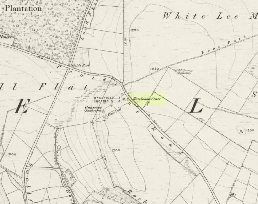
Handsome Cross on 1855 map
Described in Joseph Hunter’s (1819) rare work as being close to a now-lost stone circle, this wayside cross is shown on the earliest Ordnance Survey map of 1855 as being at the side of the old Penistone road, across from the guide-stoop which can still be seen. The cross stood at a peak on the roadside which allowed it to be visible from either direction and probably stood on the ancient township boundary line.
In Neville Sharpe’s (2002) fine survey he found an early account of this lost relic from writings ascribed to one John Wilson, who lived between 1719 and 1783, which told that,
“Ann Hawley, an old woman who lived at Broomhead in 1700, says she remembers Hanson Cross having a head and arms. The head is still there, but the arms I do not remember.”
References:
Hunter, Joseph, Hallamshire: The History and Topography of the Parish of Sheffield, Lackington: London 1819.
Sharpe, Neville T., Crosses of the Peak District, Landmark: Ashbourne 2002.
Smith, A.H., The Place-Names of the West Riding of Yorkshire– volume 1, Cambridge University Press 1961.
Take the road from Masham into this lovely hamlet and, as you reach the staggered crossroads, you’ll see a small village green with a single tree at where the four roads meet. In the grass below the tree is this forgotten monument!
Archaeology & History
Fearby Cross remains
Found at the meeting point of five old lanes, little has been written about the old cross remnants here, which is barely a foot high and rests on its roughly circular stone base. It sits where five old tracks meet and is thought to be medieval in origin. Speculation alone pronounces the site to have been a place where local council proclamations occurred, and where funerals stopped and the dead were rested.
One intriguing piece of information narrated by Edmund Bogg (1906) that may have had some relevance to the siting of this old cross, told that between here and the hamlet of Healey a mile west,
“there were formerly circles of upright stones and other relics suggestive of druidical origin.”
Any historical information or folklore relating to these apparent megalithic remains needs to be uncovered!
References:
Bogg, Edmund, Richmondshire and the Vale of Mowbray, James Miles: Leeds 1906.
The great Huddersfield historian, Philip Ahier (1948), in describing the lack of documentary evidence for several crosses in the neighbouring region, “at Deighton, Cowcliffe, Marsh and Golcar,” found out that,
“One did exist at Slaithwaite in front of the Manor House in the early past of the last century. In March 1931, the base of this cross, commonly known as the Dial Stone, was removed to Doughlas in the Isle of Man, where it rested in the garden of Mr Harry Wood; in August 1939, it was brought back to Slaithwaite and now stands in the Recreation Park.”
However, this site differs from another two that I’ve found records for on the outskirts of this township. Does anyone know what became of this old stone cross? Izzit still about? Its folk-name of the Dial Stone may make it a little easier to locate — but at the same time it does bring up the query, Why was it called that?
References:
Ahier, Philip, The Story of the Three Parish Churches of St. Peter the Apostle, Huddersfield – volume 1, Advertiser Press: Huddersfield 1948.
Dead easy. Take the A170 road from Pickering to Thornton-le-Dale and as you go into the large village, you’ll hit the old crossroads with the village green. Here be your cross!
Archaeology & History
Shown on the 1854 OS-map, I first came across a description of this old site in Creaser & Rushton’s (1972) scarce but lovely little work on the history of the old village here, where they told that,
“A cross has stood here since John de Eston in 1281 had the grant of a Tuesday market and two yearly fairs. It was repaired in 1820. Every year, the Abbot of Whitby unloaded 1500 red and 1500 white herrings here from his packhorse ponies for transhipment to the Master of St. Leonard’s Hospital at York.”
Or at least, that’s what he got folk to write down in the record-books! Close by were the old village stocks of the village (whose usage should be resurrected in many parts of this country nowadays).
References:
Creaser, A. & Rushton, J.H., A Guide and History of Thornton-le-Dale, Pickering, Yorkshire, E. Dewing: Pickering 1972.
Cross (destroyed): OS Grid Reference – SD 6573 9212
Archaeology & History
More than 150 years ago outside St. Andrew’s Church in Sedbergh, A.E. Platt wrote (1876) that,
“there was a cross standing in the Market Place adjoining the churchyard on the north, but the last remains of it, and the stone steps it stood on, were taken away some years since by private persons, and may now be seen used as gateposts to a farmyard, some ten miles from their original position.”
Intriguing stuff! Does anyone know which farmyard might still possess these old relics? When the legendary Harry Speight (1892: 443) ventured by here fifteen years later he knew little about their new location, but simply echoed what Platt had previously written. It would be good to know what has become of them…
References:
Platt, A.E., The History of the Parish and Grammar School of Sedbergh, Yorkshire, Atkinson & Pollitt: Kendal 1876.
Speight, Harry, The Craven and Northwest District Highlands, Elliot Stock: London 1892.
The old town’s Market Cross can be seen outside the north end of the Guildhall, but originally it was opposite the Ironmarket up the High Street. It was first built sometime in the medieval period (exact year seems to be unknown), but required some restoration work on it in 1579, which was organized by the town Mayor: a Mr Randle Bagnall at the time. It’s thought that the five steps upon which it stood were also erected around this time. However, these steps and the cross were moved a few years before 1820 and then resurrected by the Guildhall. The curious standard lamps were also added to the top of the cross when this restoration work was done.
References:
Kennedy, J. (ed.), Newcastle-under-Lyme: A Town Portrait, Newcastle Civic Society 1984.
This supposedly 10-12th century carving — found in the early 1940s and handed to the Scottish National Museum in Edinburgh by Mr A. Sanderson — took my interest by virtue of the distinct swastika design carved on the face of the stone.* The fact that it’s etched onto what’s thought to be the remains of an old christian cross shouldn’t be too surprising: we find it on numerous other old stone crosses, church bells and other religious remains.
This example was only carved on one side of the stone, which measures some 18-inches high and just 9 inches across. The top of the stone has a design typical of many early crosses from between the 9th to 14th century; whilst the curvaceous line on the lower-right also typifies imagery found on many crosses from this period — some of which appear to be based on cup-and-ring imagery. However, no such cup-and-rings seem to have been in evidence where this cross-remain was found. Very little else is known about its history.
Although it aint quite as old as Ilkley’s Swastika Stone, this is still a fascinating carved stone indeed!
References:
Royal Commission on the Ancient & Historical Monuments of Scotland, Peeblesshire – volume 1, HMSO: Edinburgh 1967.
Stevenson, Robert B.K., ‘The Inchyra Stone and some other Unpublished Early Christian Monuments’, in PSAS 92, 1961.
* To those who don’t know, the swastika symbol has been used by people from around 20,000 BC onwards and has only very recently gained a bad press. It’s a symbol that needs to be reclaimed, through education, and put back into its proper mythic place where it belongs – away from any Nazi dip-shits, whose retarded actions pale into insignificance when it comes to the primal archaic nature of this old form.
The same directions as for the Eastwoods Farm Cup: from Summerbridge, go west on the B6541 towards Dacre Banks, where there’s the signpost for the Nidderdale Way footpath. Follow this past the disused quarry and into the meadows. When you hit the Monk Ing road, bear right (north) and keep going till you’re 100 yards from Eastwoods Farm. Go right, down into the field for about 30 yards or so. Look around!
Archaeology & History
Described in Boughey & Vickerman’s (2003) survey as a “low, medium-sized, quadrant-shaped rock standing up from surroundings, with hollowed out central area.” This hollowed-out central area is, in all likelihood, the remains of a previously unrecognized old cross-base, although investigating archaeologists have somehow missed this. The stone’s proximity to the old Monk’s Way — a medieval trade route used by the local monastic Order — would give added weight to this assertion. A perusal of field-name records here may prove fruitful.
Our authors counted “eight possible small, badly worn cups, (with) three grooves running from central basin, all possibly natural.” The grooves may well be natural, but I’d say that one or two of the cups appear to be genuine. The large hollow in the middle of the stone may originally have been a cup-marking (or maybe even a cup-and-ring — but we’ll never know), before it became used as a site to erect a primitive cross.
Several other cup-and-ring carvings can be found around here — the Eastwoods Farm Cup is in the same field nearby— with the great likelihood of there being others hidden amidst trees or grasses, waiting to be re-awakened! The hugely impressive Morphing Stone and a prehistoric lightning-carving can be found in the next field, full of rocks, on the other side of the stream.
References:
Boughey, Keith & Vickerman, E.A., Prehistoric Rock Art of the West Riding, West Yorkshire Archaeology Service 2003.
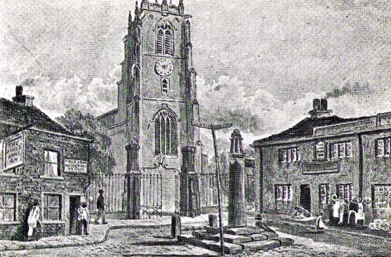
Dead easy this one! Go along North Street in Keighley, towards the main church in the middle of town (a St. Andrew’s church, previously St. Pete), by the once-infamous Lord Rodney pub, and the old stone edifice stands outside by the Green. The much better Red Pig public house is across the road from here.
Archaeology & History
Keighley’s Town Cross, 1847 – on a painting by Edwin Riby
For a relatively trivial archaeological site, it’s got a bittova history. Not that this is an old site either! We’re not sure just when this cross was made, but it’s certainly no more than 300 years old. Before standing in its present position outside St. Andrew’s Church, sometime before 1840 it was said to have been a few hundred yards away above the present roundabout on Oakworth Road; and one record tells that it originally came from nearby Utley, a mile to the north. Due to lack of decent records, we’re not sure about its early status as a market cross, nor when it was first erected. Indeed, even the steps on which the cross presently stands are clearly more recent than the ones illustrated on Edwin Riby’s 1847 portrait, reproduced here.
Keighley Cross, on a grey wet day!
It would be good to get a complete history of this archaeological relic but it’s difficult with artifacts such as these; and although gaining access to the church now takes less time and effort than it used to (the vicar here used to be quite unhelpful, but has recently changed his ways – which is good!), it’s only open at certain times of the week.* Friday afternoons seem OK to have a look round. Please – if folk begin having trouble gaining access to the Church once more, let us know on here so we can make complaints about it. The Church is paid for by local tax-payer’s cash, and so needs to be open to all of us. Let’s hope this humble ingredient can be maintained for the good of all in this otherwise regressive social community (Keighley, that is…).
There’s also some very curious folklore to be added here in relation to the market and its cross, but its tale is gonna have to wait…
References:
Gray, Johnnie, Through Airedale, from Goole to Malham, Elliott Stock: London 1891.
Keighley, William, Keighley, Past and Present, R. Aked: Keighley 1858.
* There isn’t even a notice giving information, email or phone numbers, telling you who you can contact if you want to know anything about the history of the church, or visit it — which is quite dreadful considering how much money they get paid by tax-payers for their supposed socio-spiritual duties.
From Keighley town centre, take the main road to Oakworth (B6143) and you’ll see it right by the main roadside, about a mile up on the left-hand side upon a small grassy area in Exley Head, just past the turning up to Wheathead.
Archaeology & History
The upright stone monolith, or cross, which would once have stood here has long since disappeared. All we are left with today is the large cross-base by the roadside: roughly squared, with a large hollow at the centre in which the upright stone cross originally stood erect! In the past, a number of archaeologists and historians have speculated that the Exley Head Cross dated from as early as the 9th up till the 15th century. We may never find out for certain, though it’s likely a post-Domesday medieval relic. It’s position at the roadside gives it the category of being a ‘Wayside Cross’ and it is likely one in a deliberate sequence that were placed along the ancient route from above Keighley, to Oakworth and over the border into Lancashire, near Wycoller and beyond.
Close-up of Exley Head Cross base
Quite why it was placed here is something we may never know: though it is close by an old crossroads and could have replaced an earlier heathen site, but I’ve found no records to indicate this. Its position in the landscape would also have been more impressive before the housing was here, previously giving a wide open view of the Aire Valley below. I’d be grateful for any more info on this site.
References:
Brigg, J.J. & Villy, F., “Three Ancient Crosses near Keighley,” in Bradford Antiquary, New Series 6, 1921.