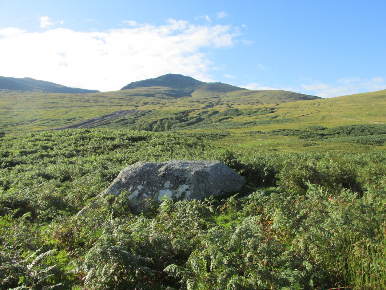
From Killin, take the A827 road to Kenmore. 6 miles along, on your right, is the track down to the Big Shed at Tombreck. Keep on the A827 for exactly ⅓-mile (0.53km), and opposite the driveway to Craggantoul is a small parking spot. A few yards on the road, over the burn, go thru the gate on your left. Follow the straight line of walling up for 400 yards it meets where another line of walling running right (E), into the boggy pasture-lands. Walk along here for roughly another 400 yards then go up the slope as if walking up Ben Lawers (N). You’ll come to 2 large boulders next to each other where the slope levels out. It’s the one on your left!
Archaeology & History
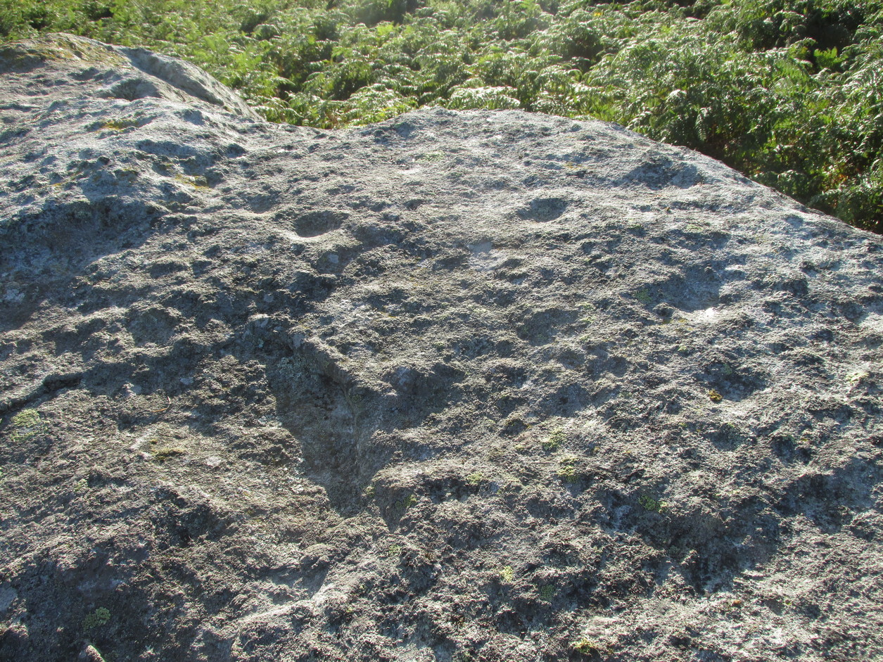
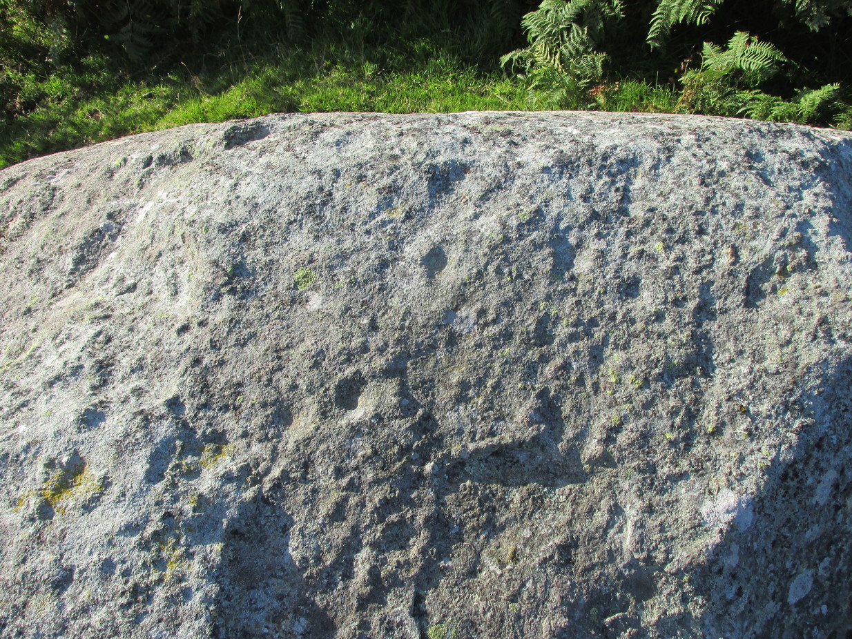
This carving is really for the purists amongst you. It’s like most of the carvings along this contour line in that the design is simplistic. Consisting of at least nine cups all on top of the stone, they can be difficult to see amidst the rough garnet and lichen-encrusted rock.
Cupmarks on its west faceLooking down on the cups
On one of our visits here, when the light cut across the surface at a lower angle, it seemed as if one of the cups had a faint ring around it; but it looked as if the outline of it had been started, but then for some reason the ring was never actually carved. This outline is very faint. We’ve found examples of this at two of the Duncroisk carvings, several miles to the west, where the faintest trace of a ring was outlined, but never carved. Of the cup-marks: five of them are carved on the east-side of the rock and are pretty easy to see (with the ring around one of them), whilst the other four—slightly more difficult to make out—are on its west side. A couple of hundred yards north you can see the Cragganester 10 carving.
Stone Circle (destroyed): OS Grid Reference – NX 7079 5018
Archaeology & History
This stone circle was destroyed sometime in the early 1780s by some moron who cared little for our ancient sites. Its destruction was described by Robert Muter in 1794—the earliest known reference to the site—when he told:
“Near the Roman camp there is a Druidical temple, which was destroyed within these eight years, by the hands of an ignorant Goth, who carried off the stones, split them, and applied them to build a contemptible bridge over an insignificant rivulet, called Buckland Burn. The stones were seven in number, of round granite, and of unequal sizes. The smallest at least three feet in diameter.”
In the 1850s, when the Ordnance Survey lads came this way to map and seek out the place-names of the area, the ‘Clownstane’ was one such place they listed. In seeking an explanation of the word, a local man told them the folk memory from seventy years prior:
“Mr. Bell of Balgreddan says the name Clownstane originated from the Stones of a Druid Circle which stood convenient to this place and which was broken up and removed to build a bridge near by.”
Fred Coles (1895) included the site in his survey of the Kirkcudbright circles, simply reiterating how,
“According to Dr Muter, the stones “were seized by some vandal for the building of Buckland Bridge.””
Stone Circle (destroyed): OS Grid Reference – NX 691 447
Archaeology & History
In an area littered with neolithic and Bronze Age remains, the great Fred Coles (1895) reported a stone circle that was destroyed sometime roughly between 1890 and 1911. When he visited the place with his colleague, Mr E.A. Hornel in 1887, the megalithic ring had already been tampered with. It was, he said,
“found to consist of five granite boulders, all of them large, in situ, and the ridgy grassy hollows of five others—removed, no one can say when. In the centre of this nearly true circle, 90 feet in diameter, is a slight mound, possibly artificial.”
In 1911, when the Royal Commission lads visited the area, they could find no stone circle and reported how “no information could be obtained concerning it” from the local farmer. This might have been because he destroyed it. Some land-owners do such things, as we know; but in this case we may never know.
The site was listed without comment in the Master’s magnum opus (Burl 2000), but he gave it the “uncertain status” category; whilst John Barnatt (1989) questioned whether this was a destroyed stone circle or merely a natural setting that Cole had misinterpreted.
References:
Barnatt, John, Stone Circles of Britain– volume 2, BAR: Oxford 1989.
Burl, Aubrey, The Stone Circles of Britain, Ireland and Brittany, Yale University Press 2000.
Royal Commission Ancient & Historical Monuments, Scotland, Inventory of Monuments and Constructions in Galloway – volume 2: County of the Stewartry of Kirkcudbright, HMSO: Edinburgh 1914.
Amongst a good cluster of petroglyphs, this ornate little fella may have been one visited by George Hamilton (1886) when he visited Balmae and outlying districts, seeking out petroglyphs! We don’t know for certain though, as his descriptions are somewhat vague. However, a few years later the great Fred Coles (1895) came a-wandering in search of the same carvings and, as happens in this line of business, uncovered a few new ones during his rummaging. This was one of them, which he described, very simply, as hiding
“but a few yards from Ross View Cottage, on its N.W. … (with) eight cups being associated with four rings and several grooves, both straight and curved.”
It was only a few years later when the Royal Commission lads (1911) came in search of it and they told how,
“the main design is a central ringed cup with a connected groove, and two outer cups which an outer circle curves eccentrically to enclose.”
But when Ron Morris (1979) explored the area in the 1970s, he was unable to locate this and a number of other carvings that had been reported by Coles. Since then, the carving has been relocated at the grid reference cited above. Also since then, a great deal many more carvings have been found in this locale by the experienced petroglyphic fingers of Maarten van Hoek. (1993)
Morris, Ronald W.B., The Prehistoric Rock Art of Galloway and the Isle of Man, Blandford: Poole 1979.
Royal Commission Ancient & Historical Monuments, Scotland, Inventory of Monuments and Constructions in Galloway – volume 2: County of the Stewartry of Kirkcudbright, HMSO: Edinburgh 1914.
van Hoek, M., “Balmae”, in Discovery & Excavation Scotland, 1993.
Healing Wells (destroyed): OS Grid Reference – TQ 3094 7889
Also Known as:
Lambeth Spa
Near Well and Far Well
Archaeology & History
This once famous healing or spa well has long gone. It was located where the buildings that now constitute 104-105 Lambeth Walk presently stand: an area which the great London historian William Thornbury (1878) told was already “a favourite resort of Londoners, and celebrated for the variety of sweet-smelling flowers and medicinal herbs growing there,” complementing the healing waters before and during the spa craze. The great herbalist John Gerard did his collections here.
I can find no information regarding its early use by our peasant ancestors, so its written history simply begins when it had been appropriated by those well-to-do up-market types who took this medicinal spring for their commercial gain in the early days of the trendy spas. Supplied by two separate springs known as the Nearer and Farther Wells respectively, the Well House built here was “formally opened in April 1696” and subsequently had almost daily accompaniments of music, including French and country dancing! But as the popularity of the Lambeth Spa increased, so did its problems. Phyllis Hembry (1990) told that by July 1715, one visitor to the spa,
“was so depressed to find that the many people there were mostly rakes, whores and drunkards, idlers such as Guard officers, or young pleasure-seeker like attorneys’ clerks, mingling with loose women of the the meanest sort. The Lambeth Wells also became a public nuisance, so a dancing license was refused in 1755.”
The so-called Great Room which had been the place of great occasions by spa users ended up being the meeting place “for Methodist meetings.” Oh how the winter nights must have flown by…..
There was a decided improvement in the years that followed and social events at the spa increased again. It became what Thornbury said “was another place of amusement.” The Lambeth Wells, he wrote,
“were held for a time in high repute, on account of their mineral waters, which were advertised as to be sold, according to John Timbs, at “a penny a quart, the same price paid by St. Thomas’s Hospital.” About 1750, we learn from the same authority, there was a musical society held here, and lectures, with experiments in natural philosophy, were delivered by Dr. Erasmus King and others. Malcolm tells us that the Wells opened for the season regularly on Easter Monday, being closed during the winter. They had “public days” on Mondays, Thursdays, and Saturdays, with “music from seven in the morning till sunset; on other days till two!” The price of admission was threepence. The water was sold at a penny a quart to the “quality” and to those who could pay for it; being given gratis to the poor. We incidentally learn that there were grand gala and dancing days here in 1747 and 1752, when “a penny wedding, in the Scotch manner, was celebrated for the benefit of a young couple.”
By this time, a rival St. George’s Spa of had been created a short distance away on the parish boundary and with it, the popularity and attendance at Lambeth Wells began to decline. By the end of the 18th century, the rot had truly set in and its days were finally numbered.
As for the medicinal properties of these wells, little seems to have been recorded. Aside from repeating the common description of them being mineral waters, William Addison (1951) simply added that they were also purgative.
References:
Addison, William, English Spas, Batsford: London 1951.
Long since gone, this great olde ash tree could once be found on the south side of Killin’s Mill building, close to the bridge at the Falls of Dochart. It was deemed to be ‘sacred’ by local people – just as all trees were, once upon a long time ago.
In John Shearer’s (1883) wonderful book on the ancient ways of the Perthshire people, he described the tree as being adjacent to the earthfast rock known as St. Fillan’s Seat:
“At the side of it grows a large ash tree which is held sacred by the natives as no person will burn any of the branches although fallen to the ground nor destroy them in any manner. However, there was one who had the hardihood to take one of the branches for a caber to repair his house. Strange to tell the first fire that was kindled burned it to the ground as a punishment for this impious sacrilege. Of course no person since has troubled it or taken any of the wood. The branches that fall lie till they rot.”
The brilliant Killin historian, W.G. Gillies (1938) reported that the tree was still standing until it was “blown down by a gale in 1893″—but it didn’t quite kill it off for good; for in September 1911, C.G. Cash visited Killin and this was one of the many places he looked for and, despite local folk telling him about the more famous St Fillan Stones (still in existence and found at the Mill), he saw the last remnants of this great Ash, telling simply that,
“the mere dead stump of St Fillan’s Ash-tree still stands against the south post of the mill gate. And quite near it is a young ash, said to be its descendant. This younger tree has an out-curving branch that was said to have been the gallows-branch in olden days; but it is obviously too young and too weak.”
…So, does anyone know precisely which is the “descendant” of St. Fillan’s Ash and where happens it to be growing?
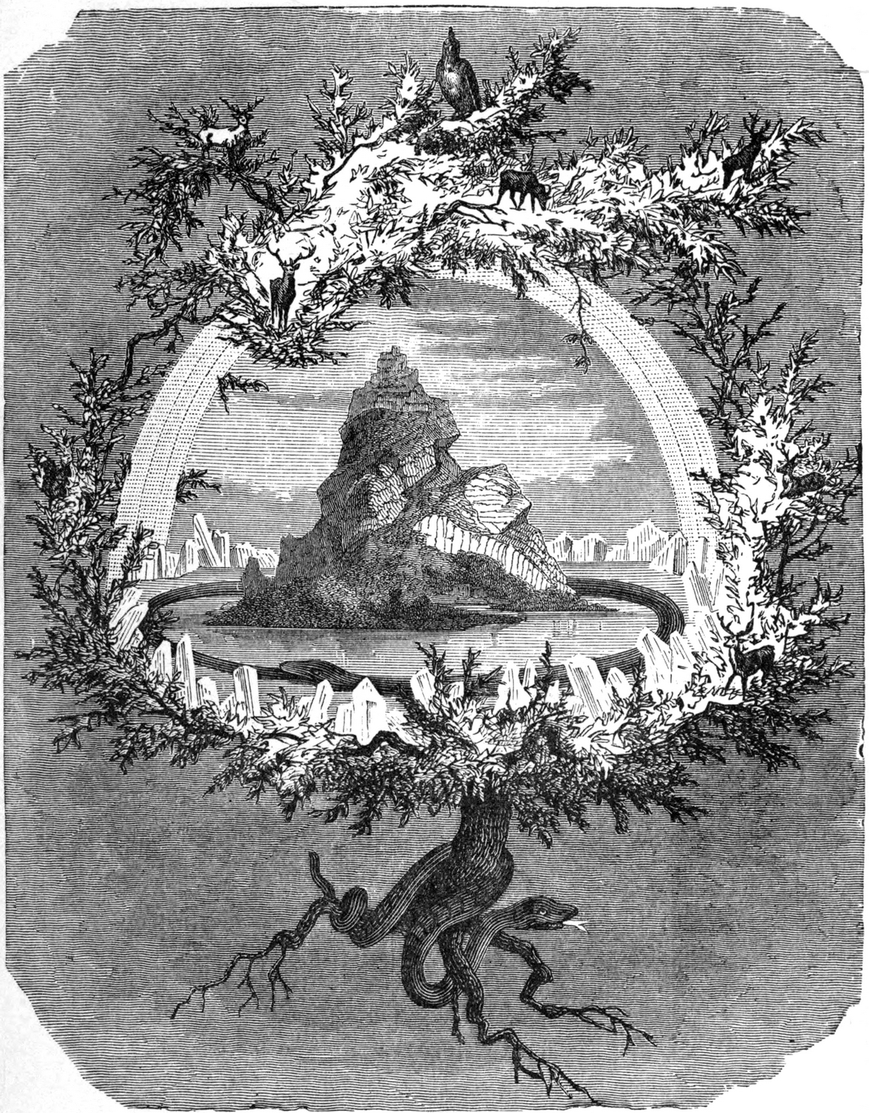
In Norse myth, the ash tree Yggdrasil was the tree of Odin and was one of the primal ingredients in their Creation myths. It stood at the centre of the cosmos: an axis mundi no less, linking the many worlds and was the abode of the gods. Its mythologies are extensive. In Scotland, the myths of the ash are not so well known, but there’s little doubt that it possessed a sanctity and certainly has many traditions of it own, which are unfortunately outside the remit of this site profile.
Crosses / Legendary Rocks (destroyed): OS Grid Reference – SE 1975 2909
Archaeology & History
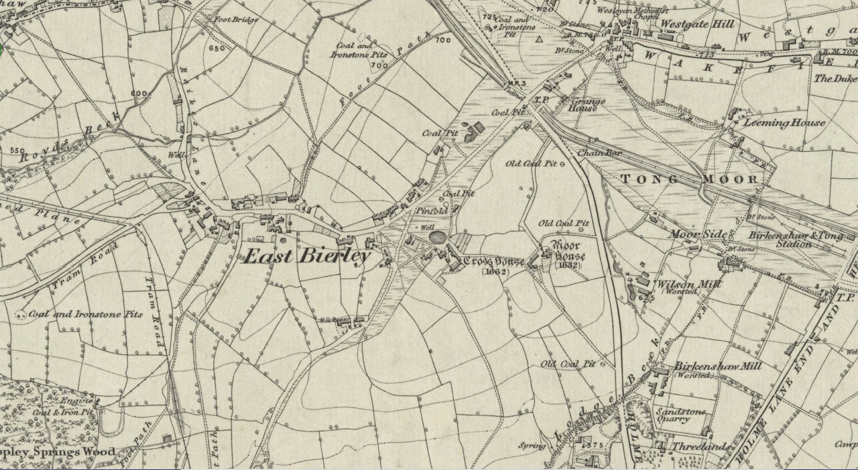
Site location at Cross House
Not to be confused with a much more renowned namesake above Ilkley, this was the name given to two old stones that once existed in the middle of the East Bierley hamlet (as it was then) southeast of Bradford. They were two large boulders next to each other, not far from the early farmstead of Cross House (see map, right) and were described in James Parker’s (1904) historic collage of the area, where he informed us that:
“On the village green (are) the primitive large stones locally called the “Cow and Calf stones,” which used to be in days gone by a Preaching Cross and Market Cross.”
When William Cudworth (1876) described the place nearly thirty years prior, he only mentioned a single cross, telling us:
“There is a lane which has long been called Kirkgate at Birkenshaw, leading up to an ancient cross on the hill. The fact of this cross being on the hill must have given rise to the name Kirk (church) gate, as there was not, until a few years ago, any church at Birkenshaw. In a previous paper we had occasion to notice the existence of the cross as an evidence of a pre-church period.”
The meaning behind the name Cow & Calf is unexplained by our respective authors, although Cudworth’s citation of “the cross as an evidence of a pre-church period” is probably not without merit here. It seems very likely that the animal names of the two large stones—akin to the Cow & Calf Rocks at Ilkley and others of the same name elsewhere in the country—that sat near the top of the hill, probably possessed a creation myth similar to others of the same name. From this, it seems logical that local folk held the rocks as important, which would have obviously attracted the regressive attention of Church—so they stuck a cross here to christianize the place and in doing so ensured that local people could continue using the place as a meeting place. This practice (as if you didn’t already know) was widespread.
Although Mr Cudworth seems to give the first real account of the place, field-name records of 1567 listed a ‘Cowrosse’, which may have been the “cross on the Cow” stone. A.H. Smith (1961) listed the site and suggested the element –rosse may derive from a local dialect word meaning a marsh, but a ‘cow’s marsh‘ seems a little odd. It is perhaps just as likely that an error was made in the writing of rosse instead of crosse.
References:
Cudworth, William, Round about Bradford, Thomas Brear: Bradford 1876.
Parker, James, Illustrated History from Hipperholme to Tong, Percy Lund: Bradford 1904.
Smith, A.H., The Place-Names of the West Riding of Yorkshire – volume 3, Cambridge University Press 1961.
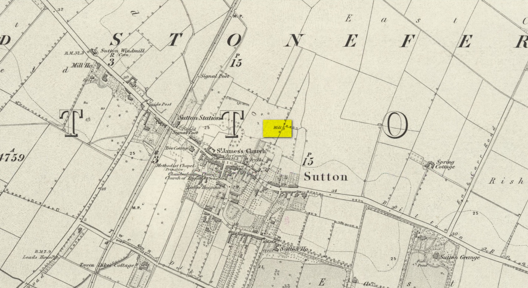
We don’t know for certain the precise whereabouts of this long lost healing well, but it would seem to be the one highlighted here (right) on the 1855 OS-map. However, I think it equally possible that the small unnamed building, roughly halfway between the highlighted ‘Well’ and Spring Cottage, where the walling meets, could be the site in question. It’s one or the other!
Folklore
When Thomas Blashill (1896) wrote of the Blind Well in his standard history work of the area, memory of it was already falling away. In discussing where local people could wash and look after their health, he told that
“There was one place in the parish where washing seems to have been practised as a curative measure. Down in the East Field, near to Spring Cottage Farm, was the Blindwell, to which the people had access. If they used its waters freely when suffering from sore eyes, their faith would probably be rewarded.”
Mentioned only in passing in the Becca and Aberford Enclosure Act of 1825, all remains of this site have gone. It was subsequently referred to by Edmund Bogg (1904) in his journey through Elmet as previously standing where the Roman road veered off to the northeast from the “new road”, as it was then. Bogg’s brief description told that from Nut Hill,
“A little distance south, where the old and new roads part, formerly stood a cross; Highcross Cottage keeps its memory green.”
References:
Bogg, Edmund, The Old Kingdom of Elmet, James Miles: Leeds 1904.
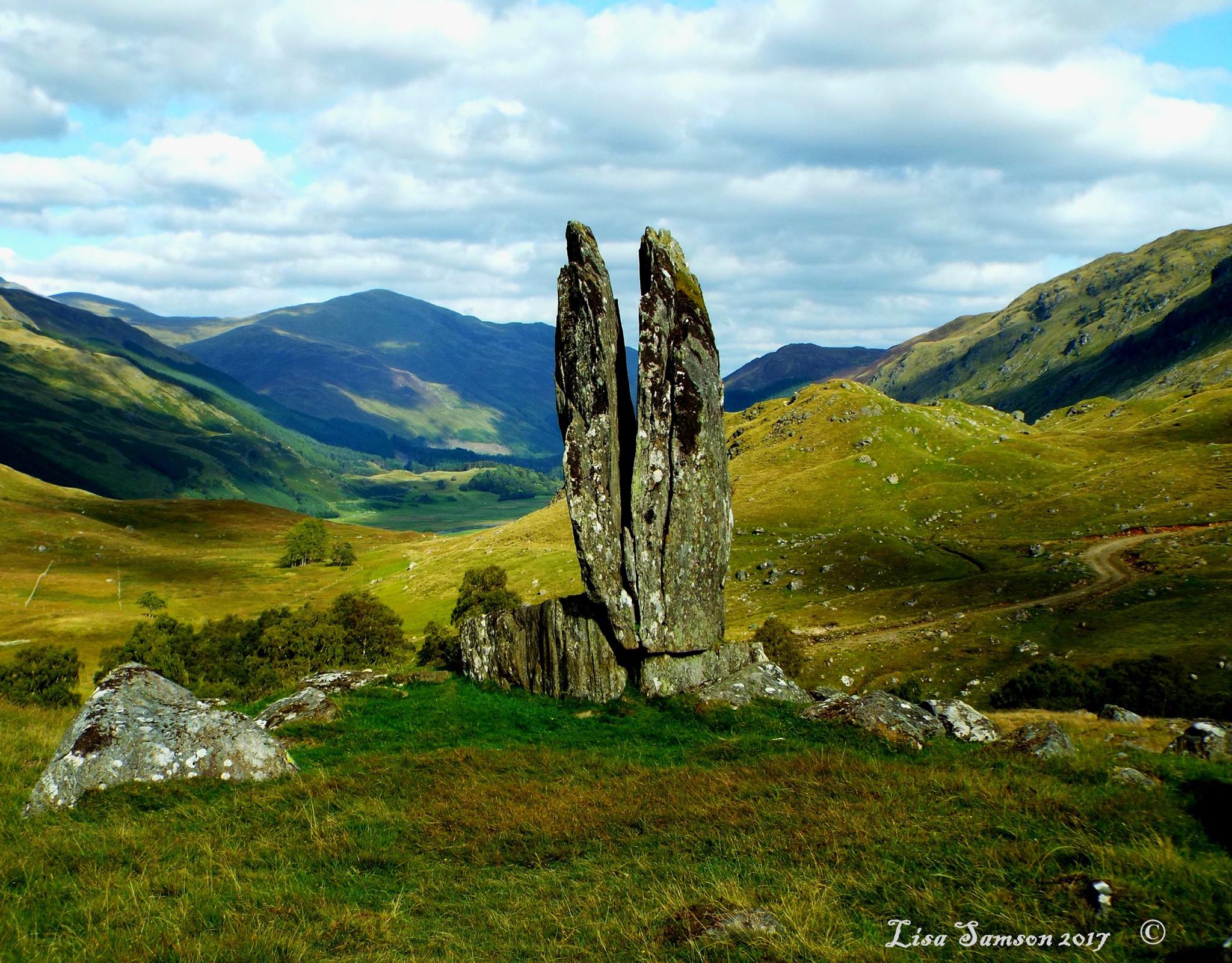
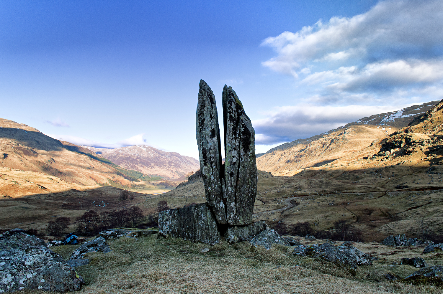
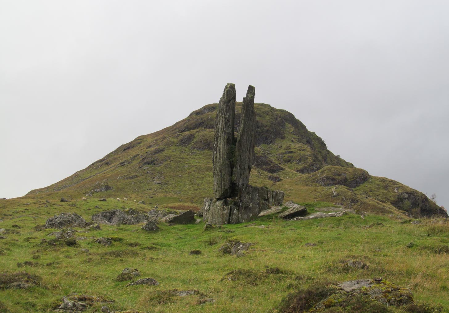
Clach na Sgoltadh, Glen Lyon (photo – Lisa Samson)
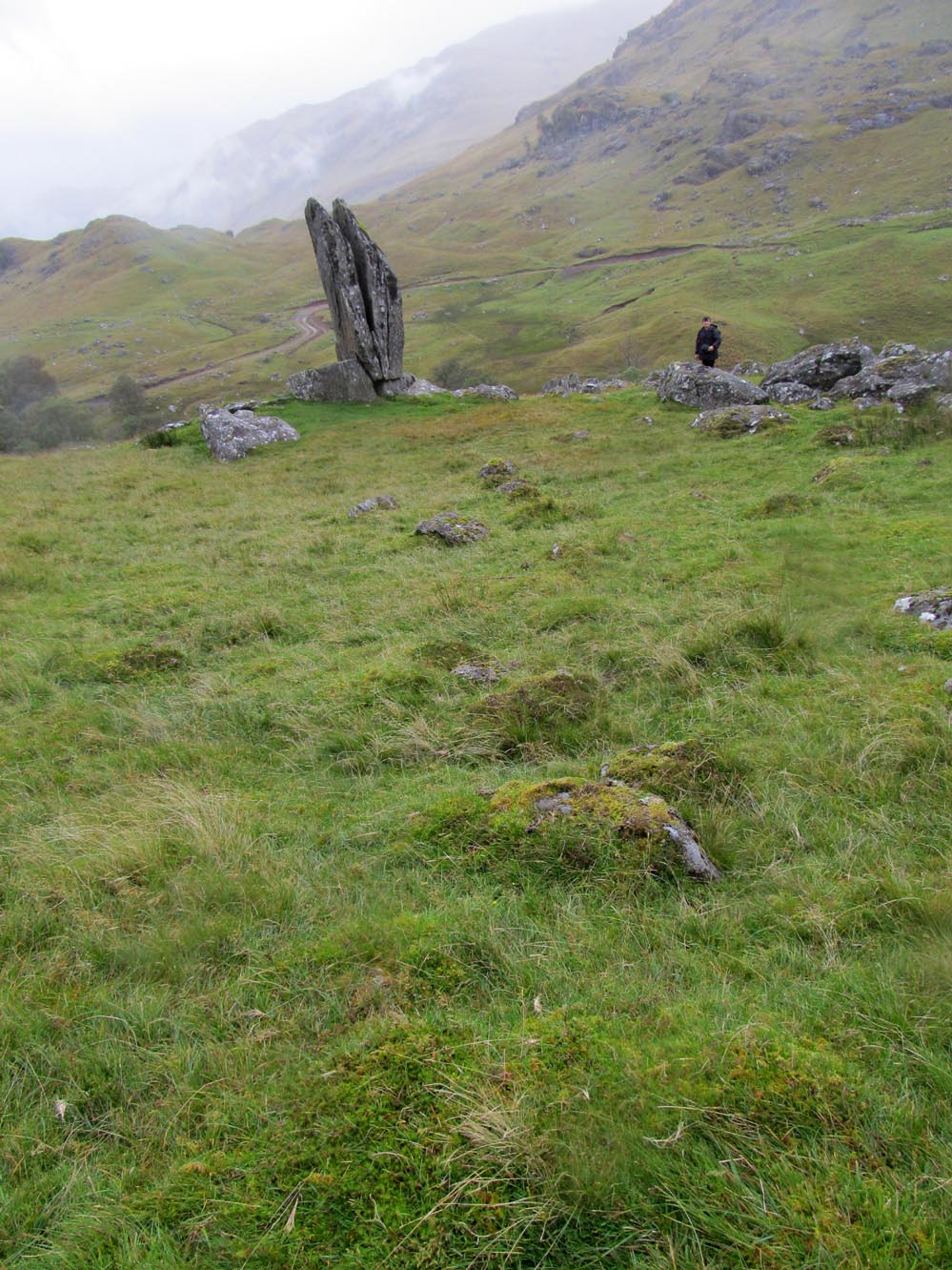
From Fortingall take the road into the legendary Glen Lyon. About 8 miles along, a short distance past the Adamnan’s Cross standing stone, you reach the tiny hamlet of Camusvrachan. On your left is a singular dirt-track, past some cottages. Go along here and over the river bridge until you reach the junction on the other side. From here, turn right and a half-mile on when you reach the farm and manor-house on your right, park up. From here you’ll see a track going uphill. Walk straight up and after a half-mile or so, keep your eyes peeled to your right. You cannot fail to see this impressive giant on the slopes above you!
Archaeology & History
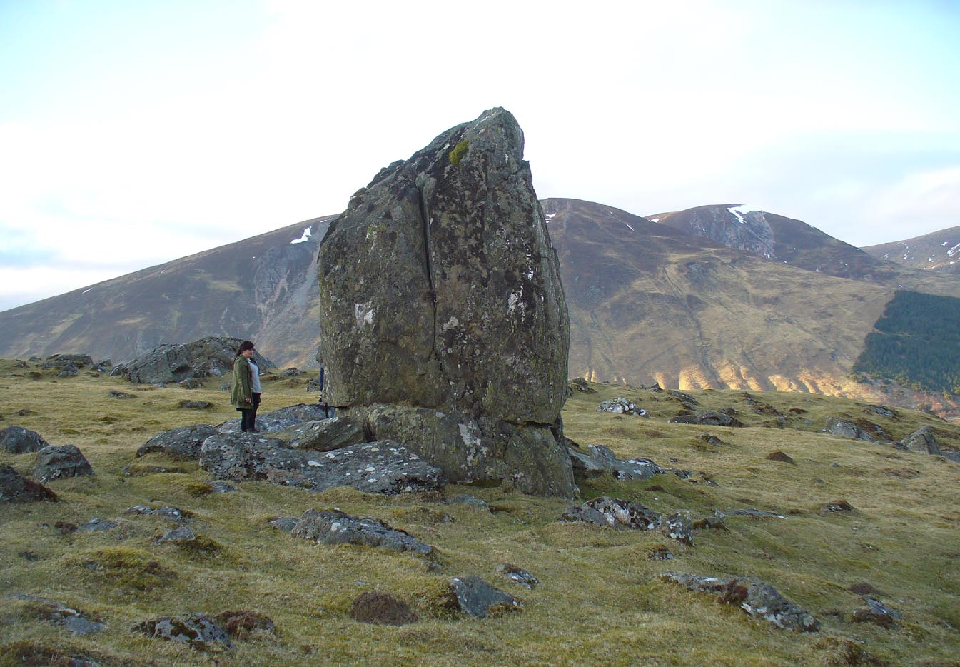
This is a truly mighty monolith! — a beauty no less! Standing upon a rocky ridge nearly halfway along the glen, the landscape it looks across is, without doubt, some of the finest in the British Isles. To our ancestors who, until just two hundred years ago peopled this and nearby glens in great numbers, this great stone would have been well known and had old myths told of it. Today we have only bare fragments.
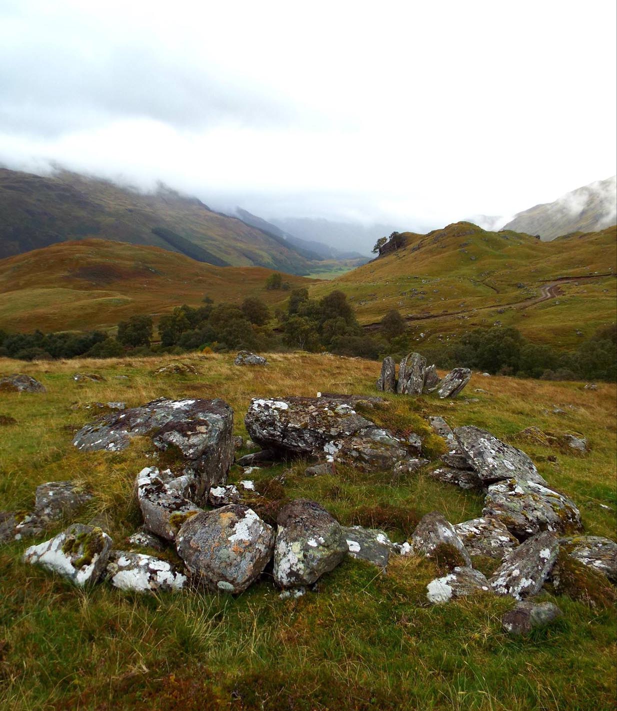
To give an ‘archaeological survey’ of any kind to this site would seem somewhat of an anathema, as it is generally deemed to be little other than one of Nature’s incredible creations. We’ll come to that in a minute. But what is quite certain is that a line of very old and very low-lying walling runs from up the slope and almost straight down to Clach na Sgoltadh. You can see it pretty clearly in the photograph below. The walling stops at the giant stone and continues no further downhill from the other side of the giant upright.
Walk diagonally down the slope about 30 yards south-east from the stone and you’ll find a small but distinctly man-made ring of stones, low to the ground, with an entrance on its northeastern side. It’s somewhat of a puzzle as it’s too small for a hut circle (I laid down in it in various ways and found you’d have to lie foetal all night if you were to use it as your own little abode), and it equally too small as an animal pen – unless it was for just one animal, which is most unlikely. The small circular construction wouldn’t seem to be prehistoric, but it would be good to know what it is.
So, we do have some very slight archaeological association with the site, albeit minimal, with the very ancient walling that leads to the stone being the most intriguing.
Small stone ‘hut’Low line of walling
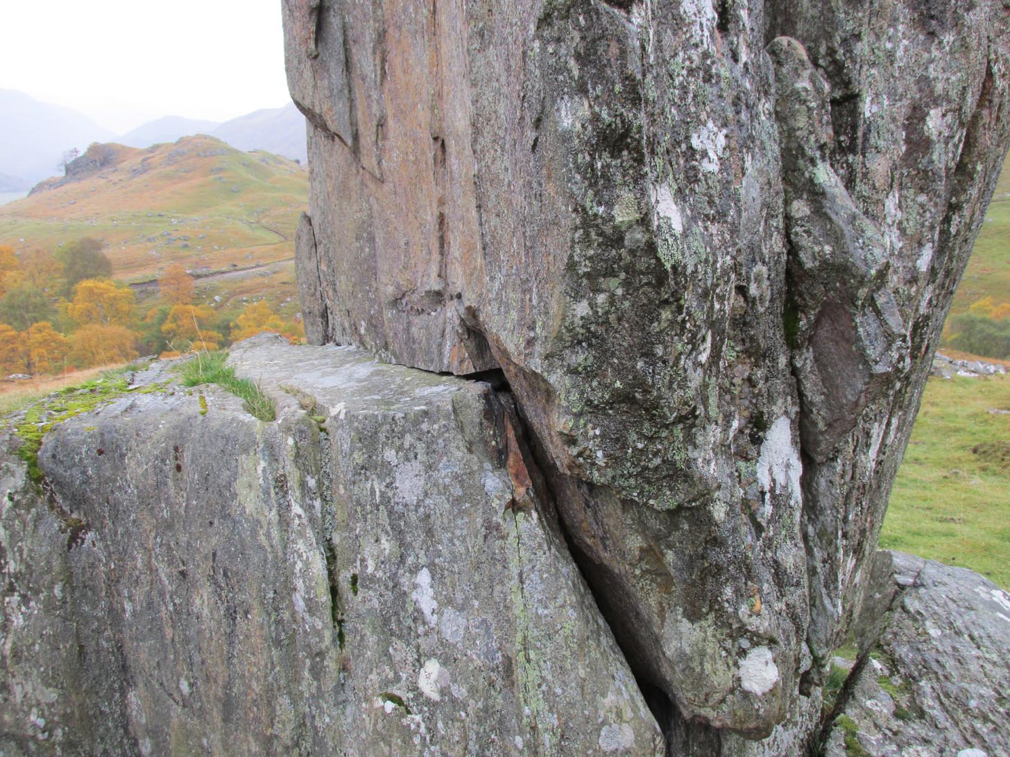
The stone is generally attributed to be a geological creation. I certainly cannot say, as I have no expertise in the subject. However, in the opinion of just about everyone with whom I’ve visited this stone, I seem to be the only one who doesn’t think it’s man-made. A number of people have each insisted to me that it’s been stood upright by humans due to the quite distinct ‘squaring’ of the upright stone, particularly at the north-facing base. —and been seemingly bemused at my own lack of conviction. It does look as if it could have been cut and squared just as they all say but, let me repeat, I’m no expert at geology, and so all I can say is that I simply don’t know one way or the other. (useless prick that I am!)
“Perhaps a stone mason might know?” someone suggested—which seemed to be a good idea. Certainly a stone mason would surely be able to tell if it had been cut and dressed at the base, where it fits into the large earthfast rock….
Cue Chris Swales: a reputable stone mason from near Skipton, North Yorkshire. Chris and his friends took a week long whistle-stop tour in and around the Loch Tay region and thought they’d visit Glen Lyon. I heard about this and so asked him if he’d have the time to visit this stone giant and, if possible, let us know his opinion: is is a natural obelisk, or does it look to have been erected by humans? I told him my opinion and that of the geologists who give it an entirely natural provenance.
It was a few weeks later when he got back in touch and I asked him if he’d been up to Clach na Sgoltadh.
“I did,” he said. “it’s bloody impressive Paul. And what a gorgeous landscape too. I’d love to go there again.”
“Aye, it is Chris. And what did you think of the giant stone then? In your opinion is it man-made or natural?”
“Well I don’t know for certain Paul,” he said, “but in my opinion I’m 95% sure that it’s man-made.” He said it plain as day, just like a typical daan-to-Earth Yorkshireman. Chris isn’t into any the energy ley-line stuff, so his words carry more weight than those who wanna spice-up a site by projecting their own beliefs onto a place. As a result, I was somewhat taken aback by his words.
“What—are you sure Chris?!” I asked.
Cut & dressed stone?
“Like I said – I’m not 100% sure Paul. I can’t really say it 100% – but I’m 95% certain that people cut and dressed the base of that stone and put it there. If it’s natural, then I’d like to know how they think that’s the case. I’m willing to be shown otherwise, but in my opinion, on the whole, it’s man-made. People stuck that stone there!”
It would be great to get another stone mason’s opinion about this site; and it would definitely be good to read a geological viewpoint, but I’m not aware of any papers regarding this stone. (does anyone know of any?) For my part: I can only reiterate that I’m ‘unsure’ whether or not this is man-made. I’m simply not qualified to give an objective opinion.
The curious thing is: if this isNature’s handiwork, then it would have been held in greater reverence to our ancestors than if it had been erected by people. Impressive creations of Nature were always deemed to be inhabited by genius loci of truly archaic potency. And in these deep impressive mountains, where the names of nature spirits still abound, this—without doubt!—would have been a place of considerable awe and sanctity. May it remain as such…
Folklore
Looking to the west immediately uphill and behind Clach na Sgoltadh is the rising rounded hill of Creag nan Eildeag. Legend has it that the great Celtic hero Fionn stood atop of this crag and fired one of his arrows at the stone, splitting it in half and leaving the stone as we see it today.
In a small cleft in the stone, quartz deposits can be seen along with an effigy of the Virgin Mary. However, the title of the Praying Hands of Mary is a modern attribution and has no historical or mythic veracity.
References:
Stewart, Alexander, A Highland Parish; or, The History of Fortingall, Alex MacLaren: Glasgow 1928.