From Masham, take the Fearby Road to the village, keep going on the same road through Healey village and less than a mile on where the road forks, bear to the right past and go along the gorgeous little-known vale of Colsterdale. It’s bloody beautiful! Less than 2 miles on, walk up the notable track veering to your right that goes diagonally uphill and past the bottom of West Agra farm along the wallside till you get to the gate. Thru the gate, follow the wall immediately uphill to the right for a coupla hundred yards until you reach a gate into the field on your right. The cluster of large boulders in front of you is where you need to be!
Archaeology & History
Cluster of cups on WAP-2b (image by ‘QDanT’)
This carving is to be found on the largest of the boulders in this cluster. It’s a large scattered cluster of cup-markings and natural bowls all over the rolling surface of the rock. It was first described in the Browns’ (2008) survey, although as they have given this and one of the adjacent stones incorrect grid-references, it made it troublesome to initially work out which carving was which! But the photos here certainly lets you know which one I’m describing! In the event that I’ve got the wrong title for this one, someone lemme know and I’ll remedy the situation!
Brown (2008) describes this design as being “cups some linked by grooves, a rectangular feature and eroded cups and depressions.” We couldn’t work out any further elements on the stone, but the cloudy conditions when we were here prohibited a decent view of the surface.
References:
Brown, Paul & Barbara, Prehistoric Rock Art in the Northern Dales, Tempus: Stroud 2008.
From Masham, take the Fearby Road to the village, keep going on the same road through Healey village and less than a mile on where the road forks, bear to the right past and go along the gorgeous little-known vale of Colsterdale. It’s bloody beautiful! Less than 2 miles on, walk up the notable track veering to your right that goes diagonally uphill and past the bottom of West Agra farm along the wallside till you get to the gate. Thru the gate, follow the wall immediately uphill to the right and, about 100 yards up, watch out for the large flat stone by the side of the footpath. You can’t really miss it.
Archaeology & History
Initially we thought that this carving was one described in Paul Brown’s work as ‘West Agra Plantation no.1’, but this is clearly a different carved stone. It is found close to WAP-1 (as he called it), but a few yard further up alongside the footpath by the walling. With two large bowls on the top of the stone and another at the edge, two average-sized cup-markings are several inches away to the bottom-right of the largest bowl. What seems to be a carved line runs from one of the cups. We need to visit this stone again and look at it when there’s better lighting conditions so we can get a more accurate assessment of its nature.
References:
Brown, Paul & Barbara, Prehistoric Rock Art in the Northern Dales, Tempus: Stroud 2008.
From Masham, take the Fearby Road to the village, keep going on the same road through Healey village and less than a mile on where the road forks, bear to the right past and go along the gorgeous little-known vale of Colsterdale. It’s bloody beautiful! Less than 2 miles on, walk up the notable track veering to your right, diagonally uphill. Walk along till you get to the moor edge. Go thru the gate and follow the swerving uphill path to the bottom of Slipstone Crags. Once you level out at the Crags top, look across the small valley to your left and, on t’other side, you’ll notice a standing stone upright in the heather, just 100 yards on the flat on the other side of the valley. Head right for it!
Archaeology & History
Looking west
There are no known written references to this standing stone, which we visited for the first time yesterday, in a brief wander to the nearby Agra Woods cup-and-ring stones a few hundred yards southeast. The monolith stands some four-and-half-feet tall and, at its base, is more than three feet broad and just one foot wide. Just to its side and almost completely covered in peat and vegetation is what may have been another once-upright companion asleep in the Earth. Another possibly fallen stone is less than 10 yards west. The upright stands on the flat moorland overlooking the confluence of two (once) fast-flowing waters of Brown Beck and Birk Gill; and the landscape that reaches out from here is something to behold!
We found the remains of other old monuments on the moor, but some were obviously related to the industrial mining not far away. However, two or three other small upright stones and a large stone circular structure were also located which very obviously predated any industrial or medieval workings. We need to revisit this moorland and spend more time exploring to see what other things are hidden, lost midst the peat and heather.
From Kelbrook village head south past Old Stone Trough then continue as far as the lane goes. Then head eastwards for about 1 mile on footpaths to a building called Laycocks. From here continue east along footpaths for another 1 mile or so until you reach Copy House (now called Hawres Farm). Go to the back of the farm where you will see in the wall a cross-incised boundary stone. At the side there is a square-shaped holy well. (You may need to ask permission at the farm).
Archaeology & History
Dissenters Well & Cross (image courtesy ‘QDanT’)
The so-called Dissenters’ Well is a rectangular feature in the ground next to the wall. It is said locally to date from the 17th-18th century, but is most probably an ancient moorland spring. The well was in use from the 17th century by Quakers, Baptists, Methodists and possibly Roman Catholics, at a time when there was much animosity towards non-Conformists. Legislation was passed stopping all illegal gatherings to be held within a 5 mile radius of any church – thus leading to religious gatherings in bleak, remote places on the moorland above towns and villages. In 1812 an Act of Parliament against non-Conformists was repealed and dissenters were given equality regarding where they could worship. The water in the well no doubt had some medicinal qualities or, was a source of spiritual up-lift at the time.
By the well there is 3 foot high pointed boundary stone or waymarker known as ‘Tom’s Cross’ and it has a thin incised cross carved onto it. The stone is partly embedded in the wall. It probably marks the old boundary between Lancashire and Yorkshire. I don’t know who Tom was though he may have been the person who set up the stone. The age of the stone is not known.
Pretty easy to find. At the eastern end of Loch Tay, go through the old village of Kenmore along the A827, towards Aberfeldy, for about a mile. At least a mile past Kenmore, keep your eyes peeled for a small left turn which takes you back into the grounds of Taymouth Castle. Go on this small road, pass the ornate walling, and you’ll see these two standing stones in front of you, before the trees, on the left. If you reach the Croftmoraig Stone Circle, you’ve gone a few hundred yards past the turning.
Archaeology & History
Fred Coles’ drawing & lay-out
These fine-looking standing stones a mile northeast of Kenmore village, on the edge of the grounds of the superb Taymouth Castle, are worthy old monoliths, encrusted by the lichens of many centuries, resting within the long grass beside the track that runs to the castle. But they have received little attention in archaeological terms. When Fred Coles (1910) described them, he thought them to be the remains of a stone circle — an impression echoed by Margaret Stewart (1966) many years later (I got the same impression aswell), but no other stones have been found to substantiate this (although Mr Gillies’ folklore remnant is intriguing). There is a notable rounded hillock immediately behind the two stones which may, or may not, have had other uprights surrounding it; though I can find no further data anywhere to substantiate such a thing.
In William Gillies’ (1938) historical survey of the area he related Mr Coles’ earlier findings of the two stones, telling us:
“There are two great standing stones just within the Principal Gate leading to Taymouth Castle. The stone A (see plan) stands at a distance of 54 feet to the NNW of B — a somewhat greater diameter than is common among the Perthshire Circles. These stones are almost equal in height — A is 4ft 9in, B is 4ft 7in — and they are both rugged blocks of a rough species of diorite. Stone A measures round the base 10ft 8in, and stone B 14ft.”
The western stoneThe eastern stone
But it seems that little else has been found about the place. It’s in a gorgeous setting (but, round here, everything’s in a gorgeous setting!) and must have related to other sites in the area, but it’s hard to contextualize the place on a single visit. If you stand behind the two stones, the shape of their ‘heads’ fits very nicely onto the rounded hillock on the northwestern skyline — which seems to have later been used as a hillfort. Whether this has any astronomical potential, I aint checked. (though Thom says nothing about them)
In geomantic terms both of these stones possess a distinct female flavour to them; the easternmost thinner of the two, particularly so. But then I could just be talking bullshit! I’d have loved to have spent more time with these two stones — bimbling, sitting, focussing, dreaming — as people of olde naturally did; but we were on the move and had other places to see. Tis a delightful spot indeed…
(NOTE – This site was first given a grid reference of NN 801 477 in Margaret Stewart’s (1967) fine essay on the standing stones at nearby Lundin; and the grid-ref has since been reproduced in texts by Burl (1993), Thom (1990) and others. Please note that this grid-ref is incorrect and is nearly a mile away from the actual position of the stones.)
Easternmost stone from another angle
Folklore
There is the possibility that this site once played a part in an important megalithic stone row. Mr Gillies (1938) once again notes an old tradition told by local people which “says that at one time there was a paved way connecting the circle, of which these stones are the remains, with the great Croftmoraig circle.” Very intriguing indeed…
References:
Burl, Aubrey, From Carnac to Callanish, Yale University Press 1993.
From Masham, head westwards along the country lanes to Fearby village (passing the old cross on the green), through old Healey village (where once stood four stone circles, seemingly destroyed) and onwards to Gollinglith. From here, keep going up the winding steep lane until you’re at the top where, on the right-hand side of the road, a footpath takes you diagonally northwest over the uphill fields. When you hit the walling which leads to the woods, follow it up and, once at the corner of the trees, follow the track back eastwards along the wall edge, keeping your eyes peeled when you pass the second line of walling that runs down the slope. You’re damn close!
Archaeology & History
One of a cluster of fascinating carvings in this remote region of the upland Dales, this is perhaps the most impressive multiple-ringed carving of the group, known collectively as the West Agra Plantation group. The carving was rediscovered sometime in 2002 by Emily McIntosh and was described by Brown & Brown (2008) thus:
“This boulder measures 5.5 x 3.1 x 1.28m and has a multiringed motif 50cm in diameter linked by a number of grooves and isolated cups.”
Teddy with his rings! (after ‘QDanT’)Primary cup-and-multiple-rings (after ‘QDanT’)
But this barely does the stone justice. The main focus is on the cup with six surrounding rings, intersected by an intrusive double-line from outside the series of rings then running into the central ring itself — though not touching the focal cup at the very centre. This double line points to the southeast and is somewhat akin to a sliver of light running to or from old solar designs. It is a little bit like some aspects of the carved stones found on Ilkley’s Panorama Stones (though Ilkley’s carvings are much fainter). At the end of the intrusive double-line is a small cluster of cup-marks. There’s also another curious singular carved line running outwards from the third ring, running out of the concentric rings then heading off further down the stone. More cups and lines scatter other parts of the stone and there may be another faint line running from near the central cup all the way out of the rings close to the main ‘ray’ of lines.
Photo by Geoff Watson
A large standing stone can be seen if you walk a few hundred yards east along the side of the wall. It’s quite impressive.
Apparently the woodland in which this carving (and its associates) can be found is supposedly ‘private’ and one is supposed to contact some group calling itself Swinton Estates to set foot in the woods. Not the sort of practice we usually put up with in Yorkshire. If anyone has their contact details, please add them below in the event that anyone has need to ask ’em about going for a walk here.
References:
Brown, Paul & Barbara, Prehistoric Rock Art in the Northern Dales, Tempus: Stroud 2008.
The Staffordshire village of Rocester is 4 miles north of Uttoxeter on the B5030 road. It can easily be reached from Stoke on Trent, Leek and Ashbourne. The church of St Michael with its interesting Medieval church-yard cross is located on Dove Lane in the centre of the pretty little, olde-worlde village.
Archaeology & History
The cross stands some 40 yards away from St Michael’s church. It is quite a striking monument standing 20 feet high and dating from the 13th century. It stands on 3 tier circular steps displaying convexed mouldings and a graduated base stone. It’s long, tapering shaft is described as “quadrilobe” which has sunken dog-tooth, or fret-work decoration on two sides. Unfortunately, the head is missing, but it’s collared coronet remains in place.
The Rocester church-yard cross was listed as Grade II in 1966 and the English Heritage Building ID is 407190.
This one’s easy as it’s right by the roadside, so making it dead easy for those lazy ones amongst you who don’t like walking! You can find it just past the turn-off (signed) for Acharn Lodge, a few hundred yards along the A827 road (off the A85 by the garage) from Lix Toll, less than a mile before reaching Killin.
Archaeology & History
This solitary standing stone, not much more than about three feet tall, originally stood in the adjacent field and was moved to the edge of the road sometime ago. It was described briefly in William Gillies’ Breadalbane (1938) where he said, “Its height is 3 feet 10 inches and its girth at the base 6 feet 2 inches… This solitary stone is possibly the sole survivor of a group that once formed a circle,” though gives no more information to support this idea. It seems more likely that the stone accompanied a cairn, that was levelled by farming sometime in the 19th century.
References:
Gillies, William A., In Famed Breadalbane, Munro Press: Perth 1938.
Settlement (destroyed): OS Grid Reference – TL 811 136
Archaeology & History
Sadly this site has been built over, as happens so much down south it seems (regional archaeo’s, architects, councillors and businesses are very much in each other pockets – even those who allege ‘pagan’ allegiances to ancient sites – hence the demise of ancient sites). Which is a pity, as it sounded a decent spot! Essex county council employee, Robin Turner, forwarded a summary of the findings from the site to The Prehistoric Society following an assessment prior to its destruction at the end of the 1970s. The brief account of what was there told:
“A small area of the site contained part of an Iron Age settlement, probably of village proportions. Three hut circles, two possible hut circles and two square four-post structures were found, as well as a number of ditched enclosures. The main settlement area was enclosed by a multi-phased series of associated palisades and ditches, the earliest of which had a causeway and external protective fence, which may have served as a defended entrance. One of the four-post structures, c.3m square, lay immediately inside the gap, and may have been a gatehouse or lookout. Three main areas were enclosed outside the settlement and are thought to have represented a stock enclosure, a working area and a field. Some evidence of pottery production, weaving, thatching and metalworking was found. The presence of unusually large quantities of deer and dog remains may have had some religious significance which carried on into the Roman period.”
Turner and his team “hoped to investigate the insdie of the settlement area more thoroughly in 1980,”but I aint been able to get a copy of the report. There was also found remains of a Roman temple here, including artifacts that were thought to have been offerings to the gods or local spirits.
References:
Champion, T.C., (ed.), “Summary Excavation Reports,” in Proceedings of the Prehistoric Society, volume 46, 1980.
Turner, Robin, “Excavations of an Iron Age Settlement and Roman Religious Complex at Ivy Chimneys, Witham, Essex, 1978-83,” East Anglian Archaeology Monograph no. 88, 1999.
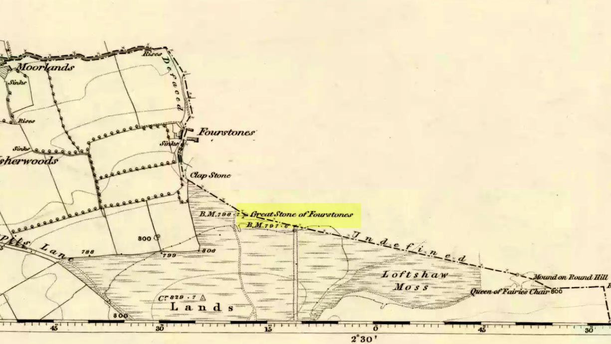
From near the middle of the large village (or small town!) of High Bentham, go down Station Road, over the river — where the road becomes known as Thickrash Brow! — and keep going for about a mile. The landscape opens up into the hills and there, on the left-hand side of the road, is a car-parking spot with a footpath taking you straight up to the large boulder a 100 yards on: that’s our Great Stone! You can’t really miss it.
Archaeology & History
Great Stone on 1847 map
A meeting place of local tribes in more ancient days, the moorland plain upon which the Great Stone sits, beckons to a vast landscape on all quarters (north, south, east and west) calling the elders from their lands for annual rites and decisions to befit the health of the land and the people. The stone rests on the ancient boundary of Yorkshire and Lancashire, just on the Yorkshire side, and was visited annually in more later centuries during the beating of the bounds, to define the edges of the local township.
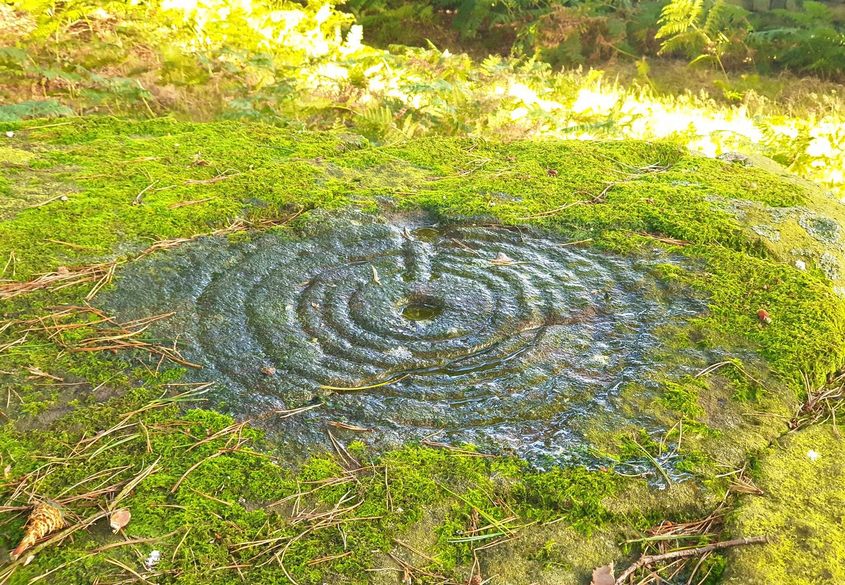
Graffiti & cup-marks on the top
First described in a Yorkshire inquisition account from 1307, this Big Stone was visited by Harry Speight (1892) who described it as measuring 30 feet round and 12 feet high. I came here for the first time in the 1980s when I was hitch-hiking into the Scottish mountains, but a good old “local” (from the Yorkshire side) took a detour to show me the place! Once here, I climbed up the very worn “steps” which were carved into the side of the boulder several centuries back and it didn’t surprise me to find a number of cup-markings (no discernible rings) on its top surface. When I came here again with Michala Potts and Paul Hornby yesterday, I couldn’t believe how many people had carved their names on top of the Great Stone in the intervening years — it’s almost covered in modern graffiti and the old cup-markings were much harder to see. Taylor (1906) mentions them briefly in his holy wells survey, saying how,
“This great boulder is ascended on its eastern side by fourteen steps, and on the top are two circular holes about two inches deep and two inches in diameter.”
There used to be three others boulders very close to this one (hence its title), making a natural stone circle, but they were “broken up for sharpening scythes” a couple of hundred years back. A much wider archaeological survey of this region is long overdue.
Folklore
Great Stone, looking east
Harry Speight (1892) told how the (original) Four Stones were the creation of our old friend the Devil, long ago, who dropped them in one his many megalithic travels across our land. The stones were also the meeting place of ancient councils, from the tribes either side of the Yorkshire-Lancashire border. Their presence here also had mythic relationship with the Queen of the Fairies Chair, about a mile southeast, along the same boundary line.
Weird how folklore changes. Whilst old Mr Speight told how the devil created the once great four stones that were here, many years later Jessica Lofthouse (1976) told how the three missing stones – which had been here “since the world began” – were actually taken from here by Old Nick. Carrying them over the land,
“His load he dropped on Casterton Fell, where the rocks he discarded, the Devil’s Apronful, are still lying around. He selected the most suitable, dressed them and carried them in panniers down to the (River) Lune”
— and built the legendary Devil’s Bridge at Kirkby Lonsdale – which itself has strange tales to tell. Another creation myth about the Great Stone is told on the plaque near the stone, alongside the footpath, which tells:
“Legend has it that it is a small part of the debris hurled by the giant Finn McCool across the Irish Sea in a fit of anger.”
It’s very obvious that a lotta mythic landscape material has been neglected and overlooked around this site. Something we need to remedy, if we can, in the coming years…
References:
Lofthouse, J., North Country Folklore, Hale: London 1976.
Speight, Harry, The Craven and Northwest Yorkshire Highlands, Elliott Stock: London 1892.
Taylor, Henry, The Ancient Crosses and Holy Wells of Lancashire, Sherratt & Hughes: Manchester 1906.


")