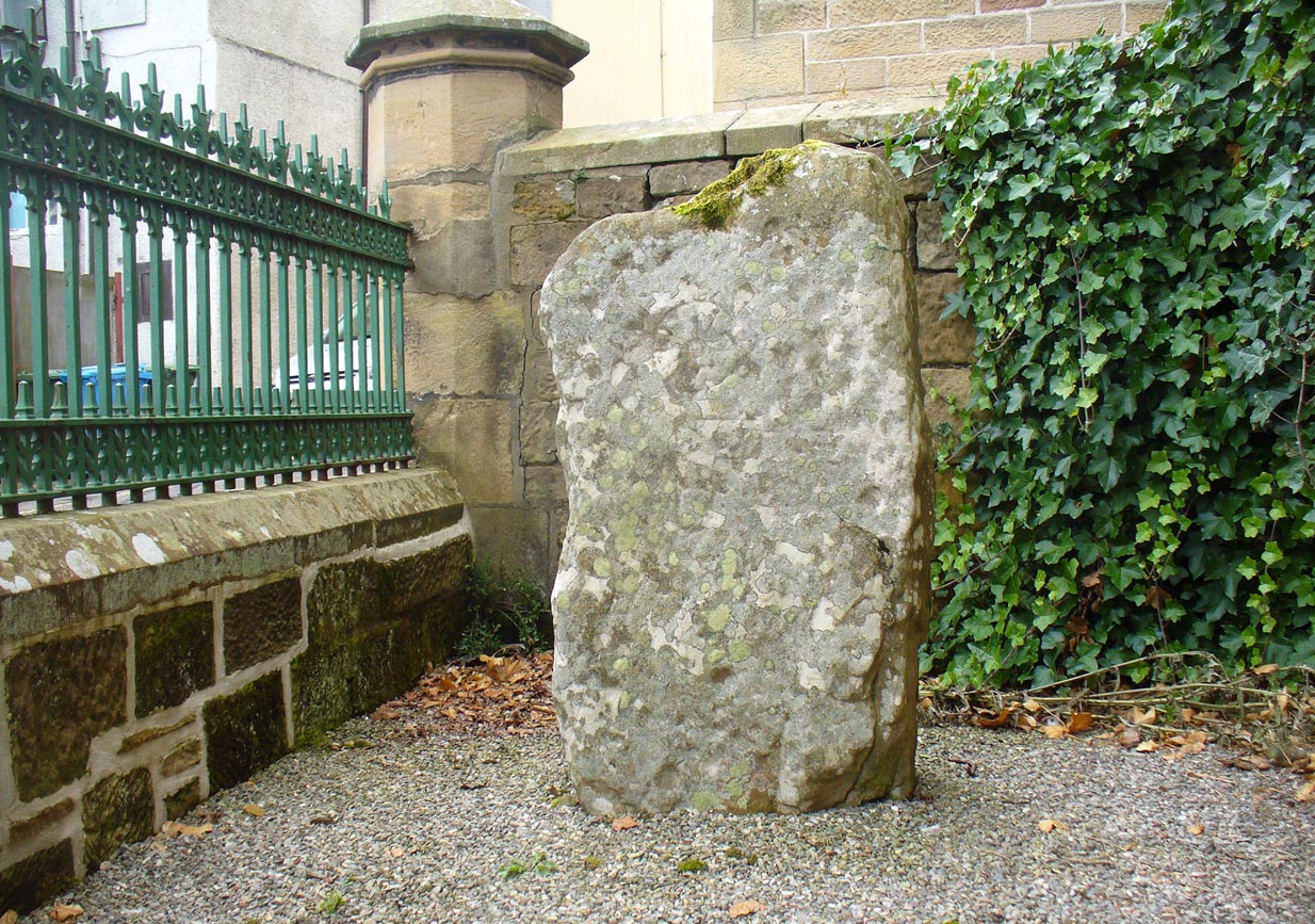
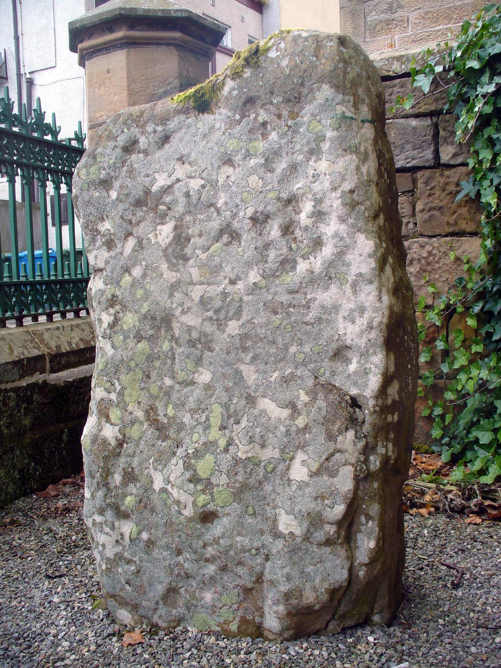
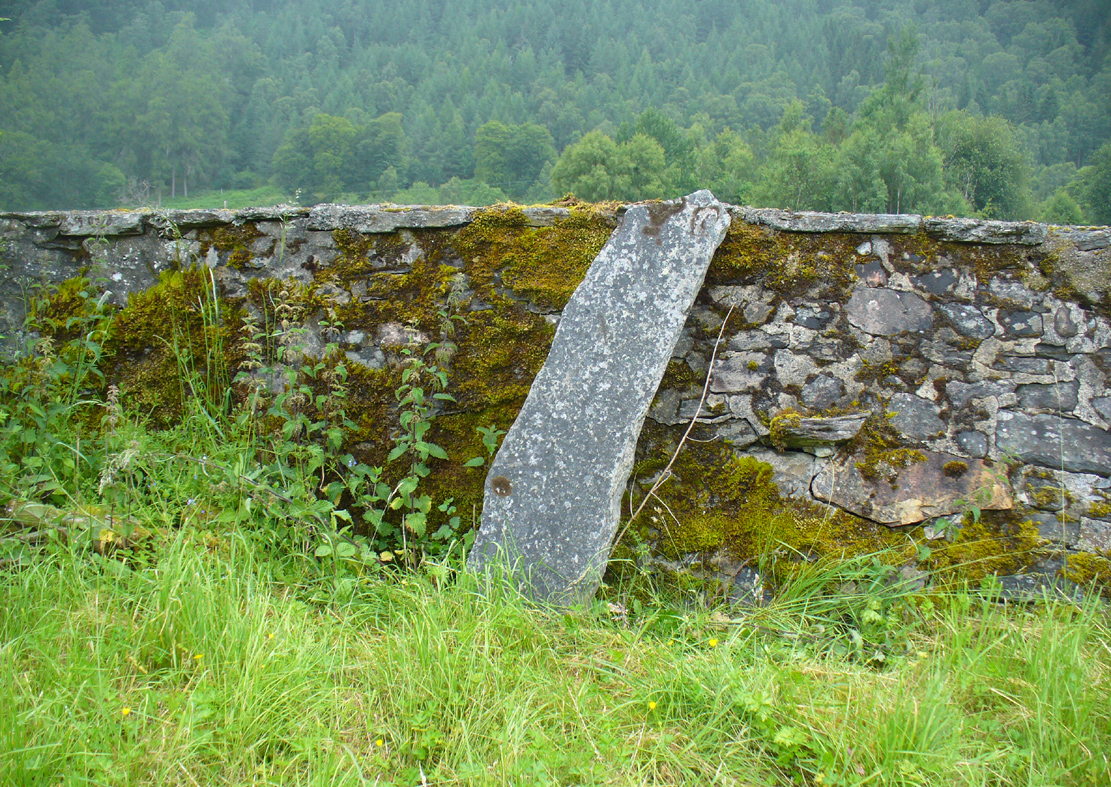
The stone is no longer in its original position (a few miles away), but can now be found if you visit the Tain & District Museum, just off Tower Street, in towards St Duthus’ Church. The stone is upright around the side of the adjacent buildings. It’s probably easier to access if you walk down Castle Brae, keeping your eyes peeled to your left. Otherwise, just ask the helpful people at the Museum and they’ll point you to the spot.
Archaeology & History
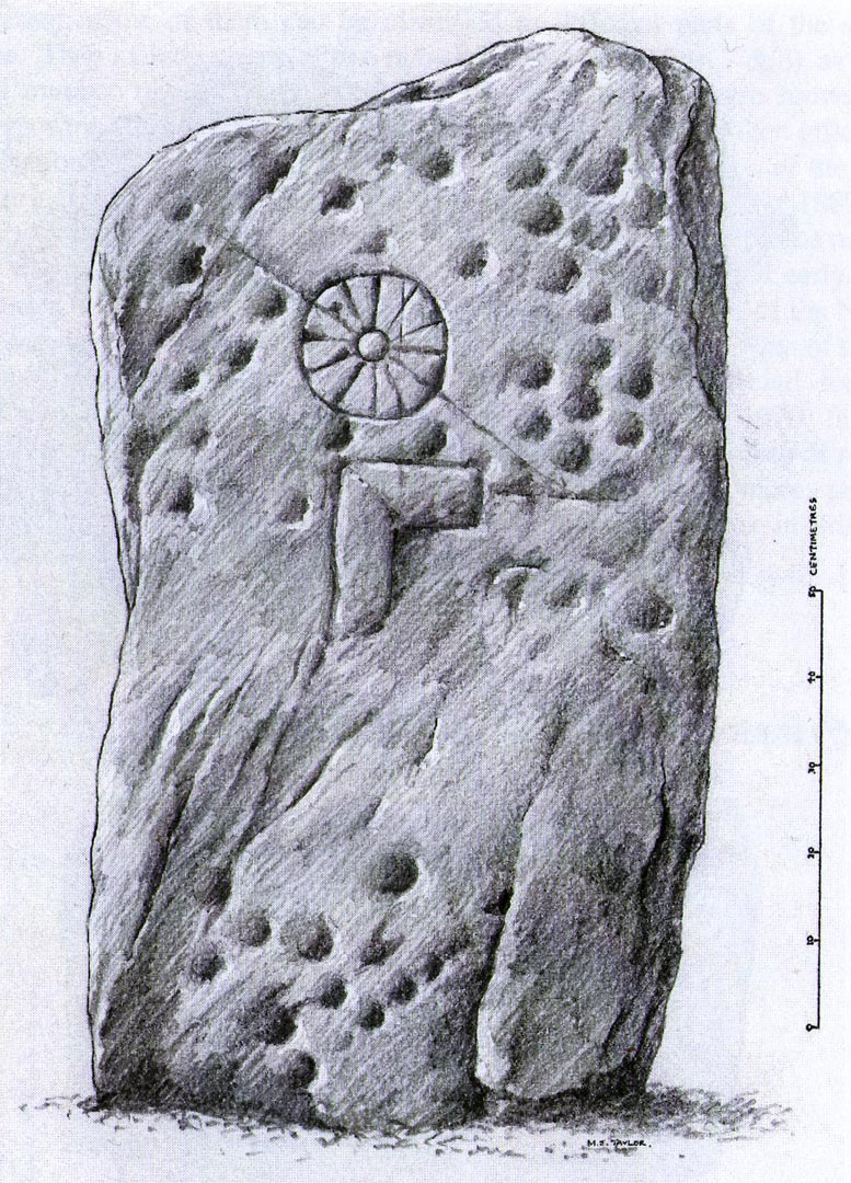
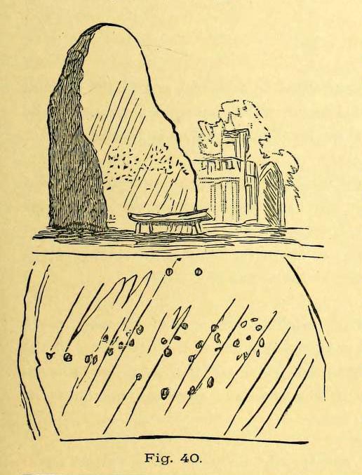
An intriguing stone with what may be a long and fascinating history behind it… It was only rediscovered in the 1960s, when the farmer at Ardjachie (2½ miles northwest of Tain town centre) came across it in one of his fields. It’s not large or notable in any way, other than it possessing a couple of really peculiar symbols etched amongst a mass of otherwise standard neolithic and Bronze Age cup-marks. These other symbols are (as seen in Mark Taylor’s drawing, right) a very distinct ‘spoked wheel’ and what looks like a right-angled ‘tool’ or set-square of some sort. These symbols have brought with them notions from academics who are claim it has Pictish provenance. However, we must be very cautious of this idea….
The first written account of the stone was by Ellis Macnamara (1971) who gave a detailed description of the carving:
Ardjachie Carving (after Mark Taylor 2004)
“Boulder found on Ardjachie Farm, now in Tain Museum. The boulder, of probably local old red sandstone, is uncut and very irregular in shape but has two principal faces; the maximum length is 1.7m; maximum width is 0.65m and on the maximum thickness is some 0.35m. The carvings are all on one face, which is much weathered; the opposing face is conspicuously less smooth so that it is possible that this stone was never set upright. The weathered face is covered with at least 30 ill-defined cup markings scattered over nearly the whole surface, though grouped towards one end; the average diameter of these cup markings is about 3 to 4cm, depth about 1.5cm. There are several indistinct lines among the cup markings and there is among the thickest cluster of cup markings a symbol like a ‘wheel’, with the outer ‘rim’ drawn as a fairly perfect circle, with a diameter at the outer edge of some 17cm. The ‘wheel’ has twelve ‘spokes’ and a single inner circle, or ‘hub’, with a diameter at the outer edges of about 4 or 5cm.”
Subsequent to Macnamara’s description, it’s been suggested that there are cup markings on both sides of the stone; but the ones on the other side are a little less certain. The stone itself almost typifies the cup-marked cist covers we find scattered all over the country—yet no burial or other structure was noted upon its discovery in the fields. It’s an oddity on various levels…
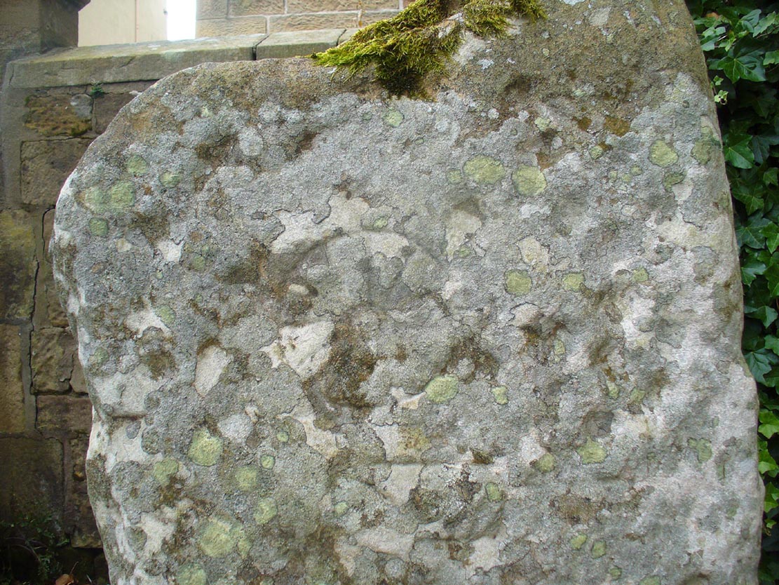
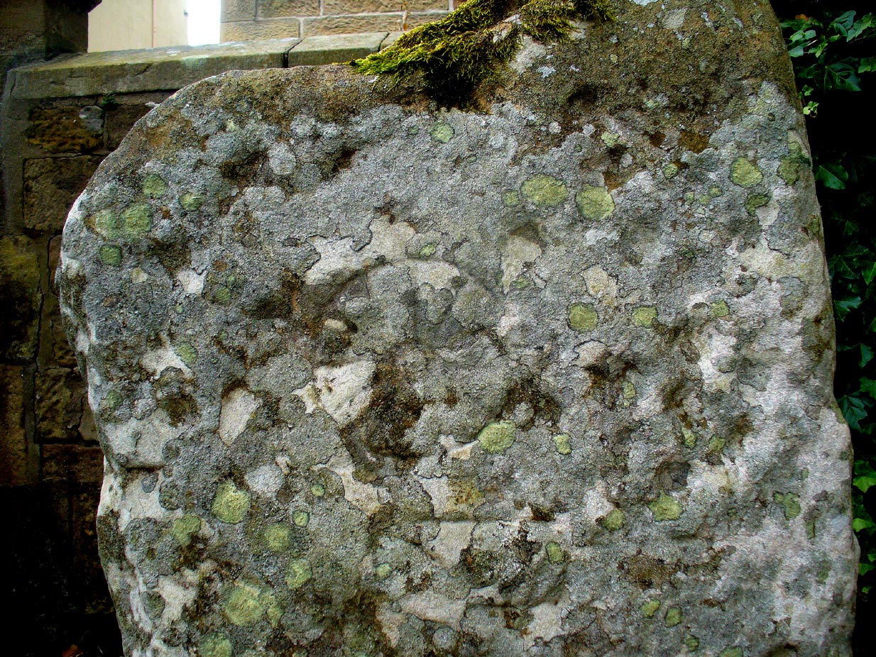
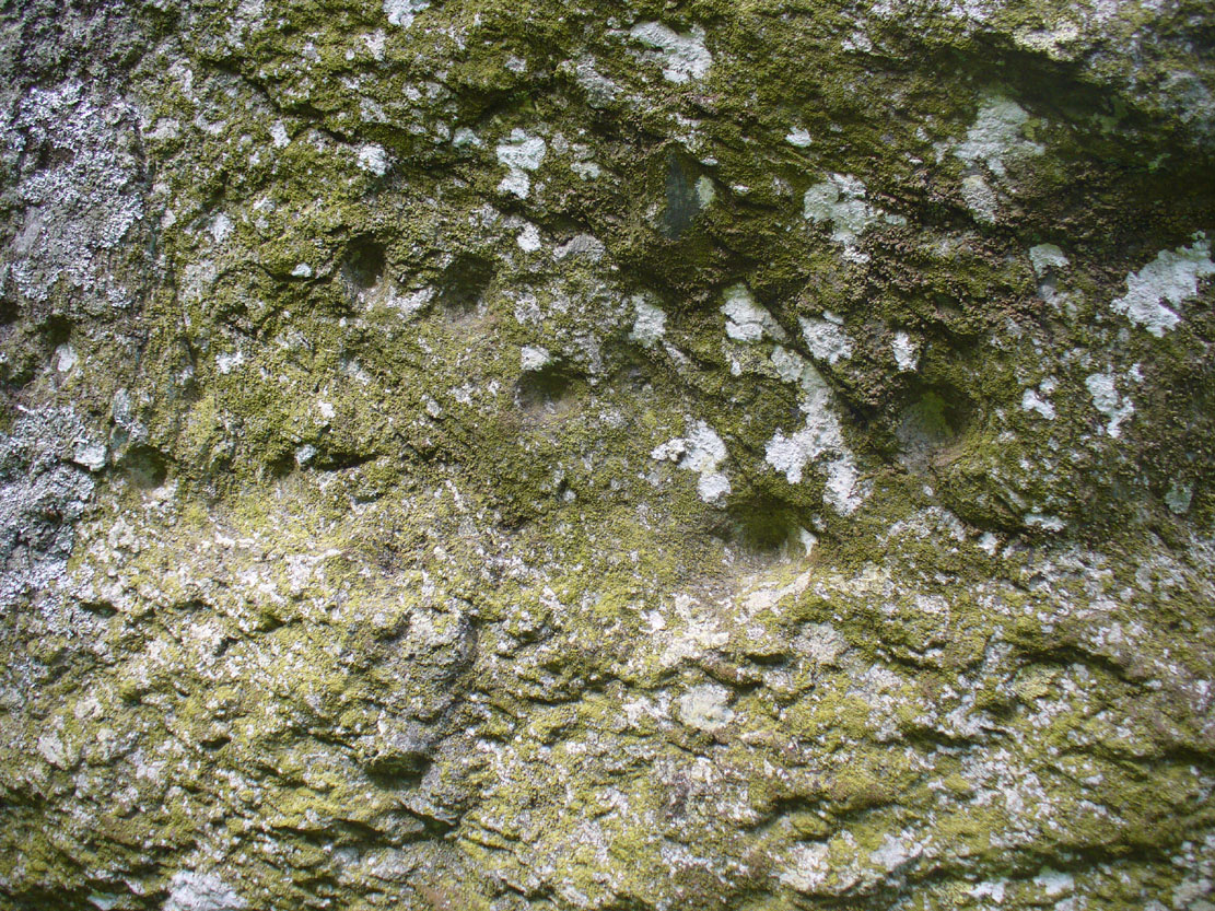
Close-up of spoked-wheelClose-up of spoked-wheel
The spoked-wheel symbol and, moreso, the right-angled element, have led some to speculate that the symbol was carved in Pictish times; but there are problems with this on two levels at least. The cup-marks we know are neolithic or Bronze Age in origin, and their design always inclines to abstract non-linear forms, screwing egocentric analysis. But the ‘spoked wheel’ is more linear in nature. But as acclaimed petroglyph researchers from George Coffey (1912) to Martin Brennan (1983) show, this spoked wheel occurs in neolithic Ireland; and the identical symbol occurs in prehistoric carvings at Petit Mont in France (Twohig 1981), at Cairnbaan in Argyll (Royal Commission 2008) and there’s even a partial spoked-ring on the Badger Stone on Ilkley Moor! We have no need to jump into Pictish times to account for its origin and unless we have direct archaeological evidence to prove this, the academic Pictish association must be treated with a pinch of salt. It is nevertheless scarce amongst neolithic and Bronze Age carvings in Britain. Maarten van Hoek (1990) suggested it to be a variant on the ‘rosette’ design, also neolithic in origin. On the whole the symbol is interpreted as being the sun—which it may well be.
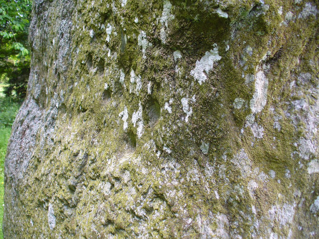
If you look carefully at the images above you can see, to the right of the ‘wheel’, a cup-marking surrounded by a ring of six-cups. It is possible that this may be an older variant of the spiked-wheel solar symbol. All speculation of course. The other peculiar element here is the curious right-angled design, below the ‘sun’. This symbol in particular is quite different from the early cup-marks and may have been carved at a much later date. In which case, this raises the potential for a continuity of tradition here… which mightjust bring in the Picts!
A bittova closer look
But the general problem with a Pictish assignment is that of the Picts themselves. If we ascribe the current anglocentric belief that the Picts only existed between the 3rd and 9th centuries (because we only have written records of them during that period), we are assuming the rather naive philosophy that anything before written history did not exist: a sort of blind-man’s Schrodinger’s Cat ideology, only really accepted by pseudo-historians. But if the Picts didhave something to do with this carving, we may indeed be talking about a continuity of tradition from the ancient past into the written period. Such an idea would be no problem in developed tribal cultures with an animistic cosmology—and that’s assuming that this stone was deemed as ‘special’ in some form or another to the local people. But all these are uncertainty principles in themselves and we may never know for sure…
There are no adjacent monuments to where Ardjachie’s stone came from, and apart from a scatter of flints found a hundred yards or so closer to the beach, other archaeological remains are down to a minimal. Its isolation is peculiar. There are however, a number of springs of water a few hundred yards away, just across the main A9 road, two of which have left their old names with us as the Cambuscurrie Well and the Fuaran nan Slainte, or fountain/spring of Healing (the modern Glenmorangie whisky gets it waters hereby!). Although we must be careful not to assign every example of prehistoric rock art with the same material, the mythic association between petroglyphs and water cannot be understated, and although such an association at Ardjachie is conjectural, it cannot go unnoticed.
References:
Brennan, Martin, The Stars and the Stones: Ancient Art and Astronomy in Ireland, Thames & Hudson: London 1983.
Coffey, George, New Grange and other Incised Tumuli in Ireland, Hodges Figgis: Dublin 1912.
McHardy, Stuart, A New History of the Picts, Luath: Edinburgh 2012.
Mack, Alastair, Symbols and Pictures: The Pictish Legacy in Stone, Pinkfoot Press: Brechin 2007.
Macnamara, Ellen, “Tain, Ardjachie Farm: Cup Markings and Incised Symbol”, inDiscovery & Excavation Scotland, 1971.
From the centre of Meigle village, you need to head along the country lane south-west towards the village of Ardler (do not go on the B954 road). About three-quarter of a mile (1.25km) along—past the entrance to Belmont Castle—you’ll reach a small triangle of grass on your left, where a driveway takes you into the trees. Walk down the drive and past the very first house—behind which is the stone in question. A small path takes you through the trees allowing you to get round to it. You can’t really miss it!
Archaeology & History
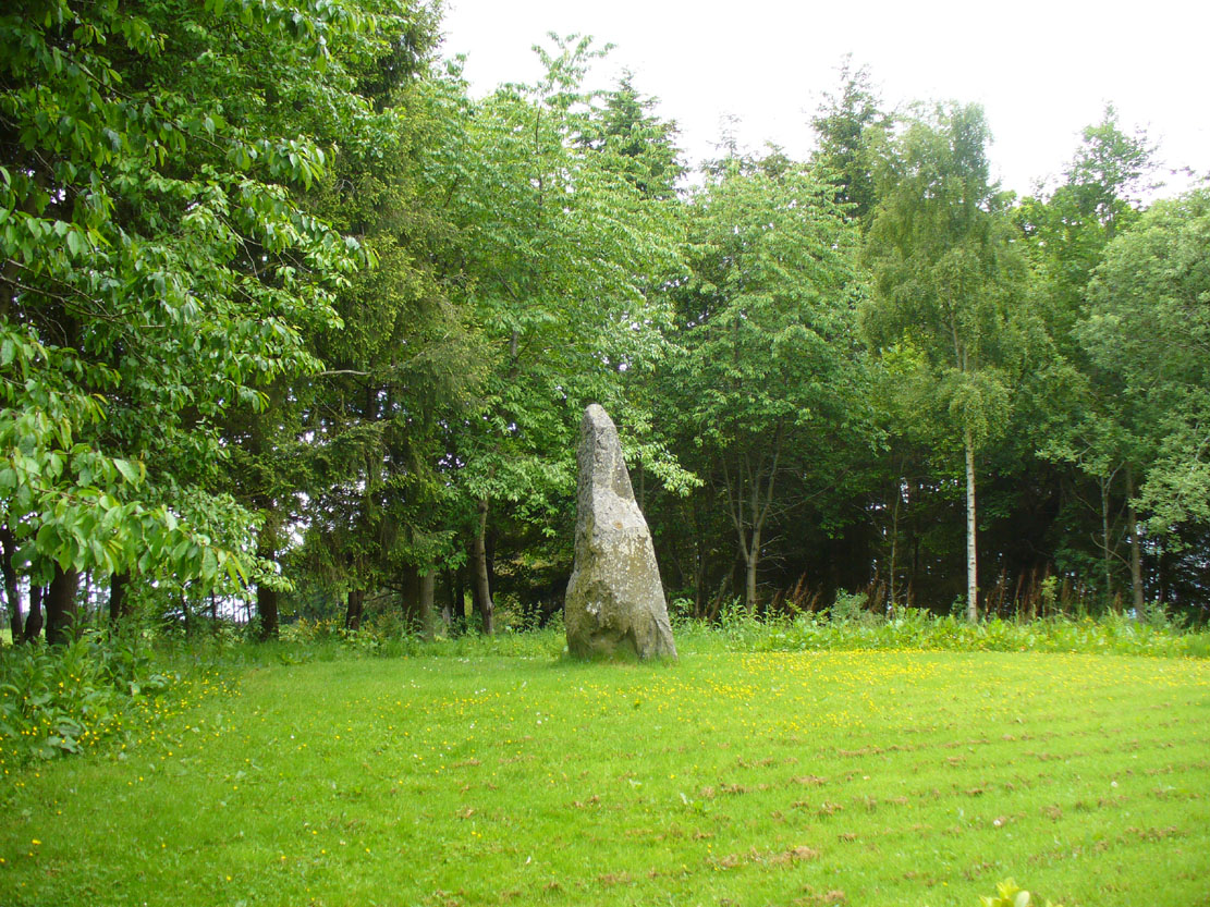
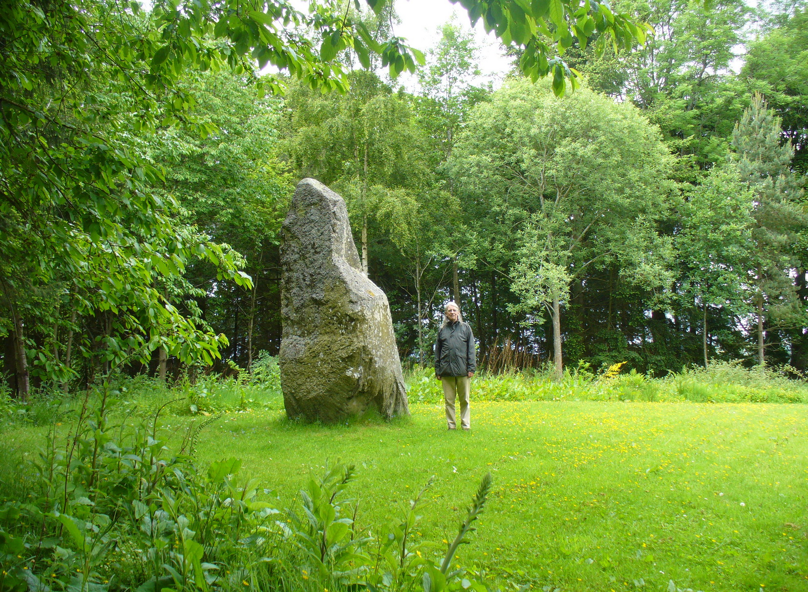
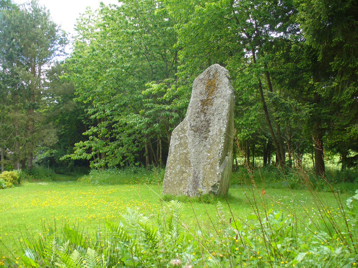
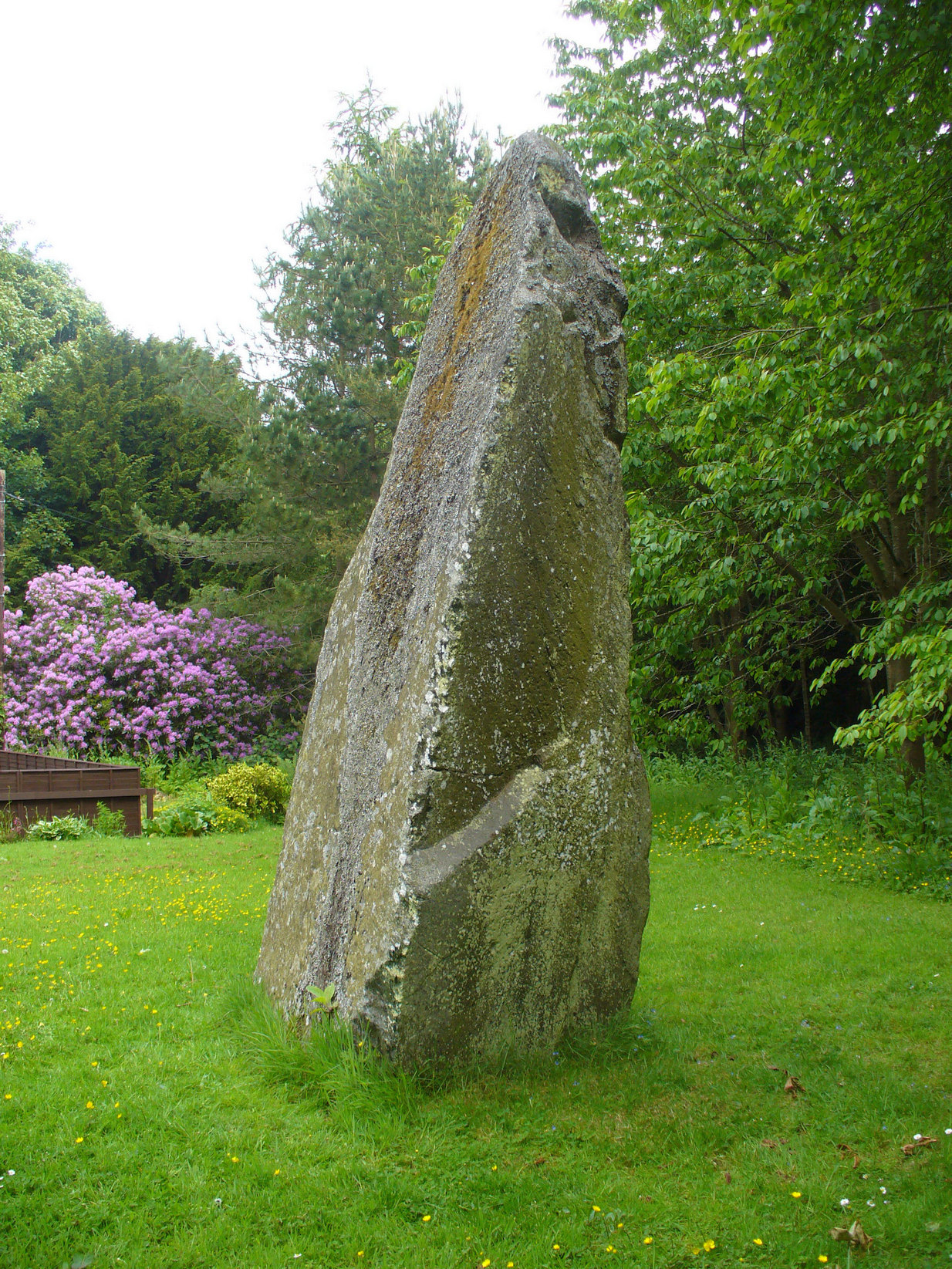
This is a magnificent site. A giant of a stone. Almost the effigy of a King, petrified, awaiting one day to awaken and get the people behind him! It has that feel of awe and curiosity that some of us know very well at these less-visited, quieter megalithic places. Its title has been an interchange between the Scottish King MacBeth and the witches who played so much in his folklore, mixed into more realistic local traditions of other heathen medicine-women of olde…
The first account of this giant standing stone came from the travelling pen of Thomas Pennant (1776) who, in his meanderings to the various historical and legendary sites of Meigle district, wrote that
“In a field on the other side of the house is another monument to a hero of that day, to the memory of the brave young Seward, who fell, slain on the spot by MacBeth. A stupendous stone marks the place; twelve feet high above ground, and eighteen feet and a half in girth in the thickest place. The quantity below the surface of the Earth is only two feet eight inches; the weight. on accurate computation amounts to twenty tons; yet I have been assured that no stone of this species is to be found within twenty miles.”
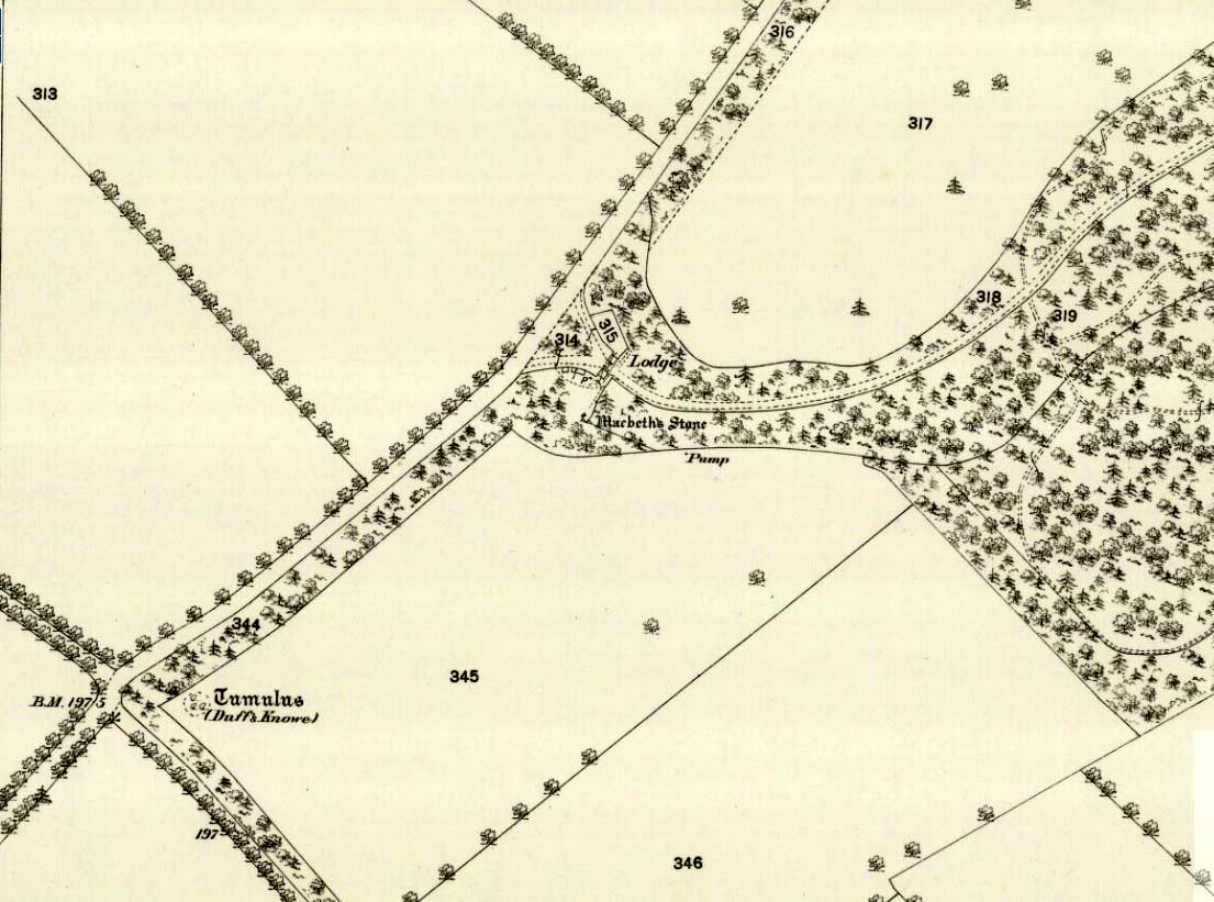
Site shown on 1867 mapA human & MacBeth!
It was visited by the Ordnance Survey lads in 1863, several years after one Thomas Wise (1855) had described the monolith in an article on the nearby hillfort of Dunsinane. But little of any substance was said of the stone, and this is something that hasn’t changed for 150 years, despite the huge size of this erection! Local historians make mention of it in their various travelogues, but the archaeologists haven’t really given the site the attention it deserves. Even the Royal Commission (1994) report was scant; and apart from suggesting it to have a neolithic provenance, they merely wrote:
“Rectangular in cross-section, the stone tapers to a point some 3.6m above the ground; each of its sides is decorated with cupmarks, as many as forty occurring on the east face and twenty-four on the west.”
East face of MacBethMacBeth Stone (Wise 1884)
Thankfully, the fact that there are cup-markings on the stone has at least given it the attention it deserves amongst the petroglyph students. The first account of the cup-markings seem to have come from the pen of Sir James Simpson (1867) who mentions them, albeit in passing, in his seminal work on the subject. A few years later however, the same Thomas Wise visited MacBeth’s Stone again, and not only described the carvings, but gave us our first known illustration in his fascinating History of Paganism (1884). He told it to be,
“A large boulder, some 12 tons in weight, situated within the policies of Belmont Castle, in Strathmore, Perthshire…is supposed to have been erected on the spot where MacBeth was slain. Two feet above the ground this boulder has a belt of cups of different sizes, and in irregular groups. None of these cups are surrounded by incised circles or gutters. This boulder was probably intended for some sacred purpose, as it faces the SE.”
Running almost around the middle of the standing stone, on all four sides, are the great majority of the cup-markings (no rings or additional lines are visible). They were very obviously etched into the stone after it had been erected, not before. This is in stark contrast to the cup-and-rings found on the standing stones at Machrie, Kilmartin and elsewhere, where we know the carvings were done before the stones were stood upright.
Cup-marks on west sideCup-marks on west face
On the northern face of the stone is one possible cup-marking, and three of them are etched onto its south face; but the majority of them, forty, are on its western face, and twenty-five on its eastern side. The great majority of them on the east and west sides occur roughly in the middle of the stone, almost like a ‘belt’ running across its body. Those on the eastern face are difficult to discern as a thick layer of lichens covers this side, so there may be even more beneath the vegetation.
One of the notable features of the monoliths across this region, and echoed again here, is that one side of the standing stone is smooth and flat—and here in the case of MacBeth’s Stone, the flat face is the eastern one. Whether this feature was deliberately intended (it seems to have been) and what it might imply, we can only guess. It might simply relate to the geophysics of the stone, making it easy to crack horizontally….
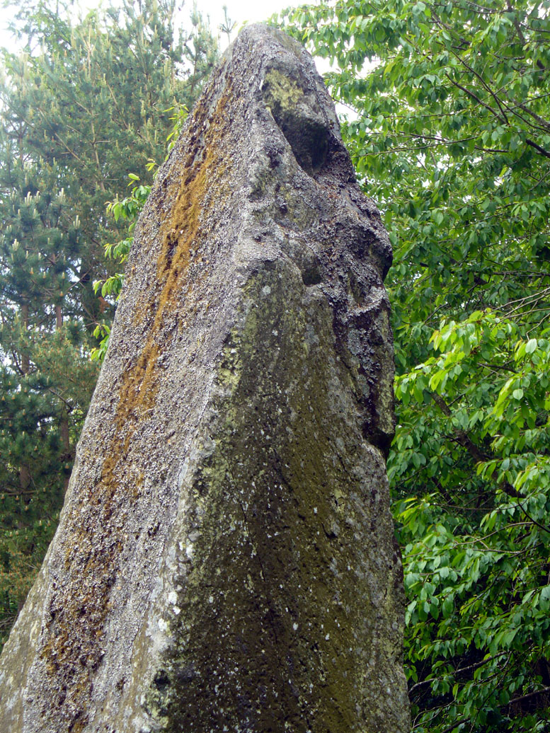
The ‘face’ in the top of the stoneClose-up of Macbeth’s face
Another fascinating feature at this site was noticed by Nina Harris of Organic Scotland. Meandering around the stone in and out of the trees, she called our attention to a fascinating simulacra when looking at the upper section of the stone on its southern side. At first it didn’t seem clear – but then, as usual, the more you looked, the more obvious it became. A very distinct face, seemingly male, occurs naturally at the top of the stone and it continues as you walk around to its heavily cup-marked western side. It’s quite unmistakable! As such, it has to be posited: was this simulacra noticed by the people who erected this stone and seen as the spirit of the rock? Did it even constitute the reason behind its association with some ancestral figure, whose spirit endured here and was petrified? Such a query is neither unusual nor outlandish, as every culture on Earth relates to such spirit in stones where faces like this stand out.
But whatever your opinion on such matters, when you visit this site spend some time here, quietly. Get into the feel of the place. And above all, see what impression you get from the stony face above the body of the stone. Tis fascinating…..
Folklore
Known locally as being a gathering place of witches, the site is still frequented by old people at certain times of the year, at night. The stone’s association with MacBeth comes, not from the King himself (whose death occurred many miles to the north), but one of his generals. In James Guthrie’s (1875) huge work on the folklore of this region, he told that this giant
“erect block of whinstone, of nearly twenty tons in weight…(is) said to be monumental of one of his chief officers”,
which he thought perhaps gave the tale an “air of probability about it.” But Guthrie didn’t know that this great upright was perhaps four thousand years older than the MacBeth tradition espoused! However, as Nick Aitchison (1999) pointed out in his singular study of the historical MacBeth,
“another MacBeth was sheriff of Scone in the late twelfth century and it is possible that he, and not MacBeth, King of Scots, is commemorated in the name.”
He may be right. Or it the name may simply have been grafted onto the stone replacing a more archaic relationship with some long forgotten heathen elder. We might never know for sure.
When Geoff Holder (2006) wrote about the various MacBeth sites in this area, he remarked that the folklore of the local people was all down to the pen of one Sir John Sinclair, editor of the first Statistical Account of the area—but this is a gross and probably inaccurate generalization. Nowhere in Holder’s work (or in any of his other tomes) does he outline the foundations of local people’s innate subjective animistic relationship to their landscape and its legends; preferring instead, as many uninformed social historians do, to depersonalise the human/landscape relationships, which were part and parcel of everyday life until the coming of the Industrial Revolution. Fundamentally differing cultural, cosmological and psychological attributes spawned many of the old myths of our land, its megaliths and other prehistoric sites. It aint rocket science! Sadly, increasing numbers of folklore students are taking this “easy option” of denouncement, due to educational inabilities. It’s about time researchers started taking such misdirected students to task!
References:
Aitchison, Nick, MacBeth – Man and Myth, Sutton: Stroud 1999.
Coutts, Herbert, Ancient Monuments of Tayside, Dundee Museum 1970.
Royal Commission on the Ancient & Historical Monuments of Scotland, South-East Perth: An Archaeological Landscape, HMSO: Edinburgh 1994.
Simpson, James, Archaic Sculpturings of Cups, Circles, etc., Upon Stones and Rocks in Scotland, England and other Countries, Edmonston & Douglas: Edinburgh 1867.
Acknowledgements: With huge thanks to Paul Hornby for his help getting me to this impressive monolith; and to Nina Harris, for prompting some intriguing ideas.
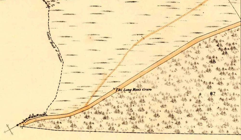
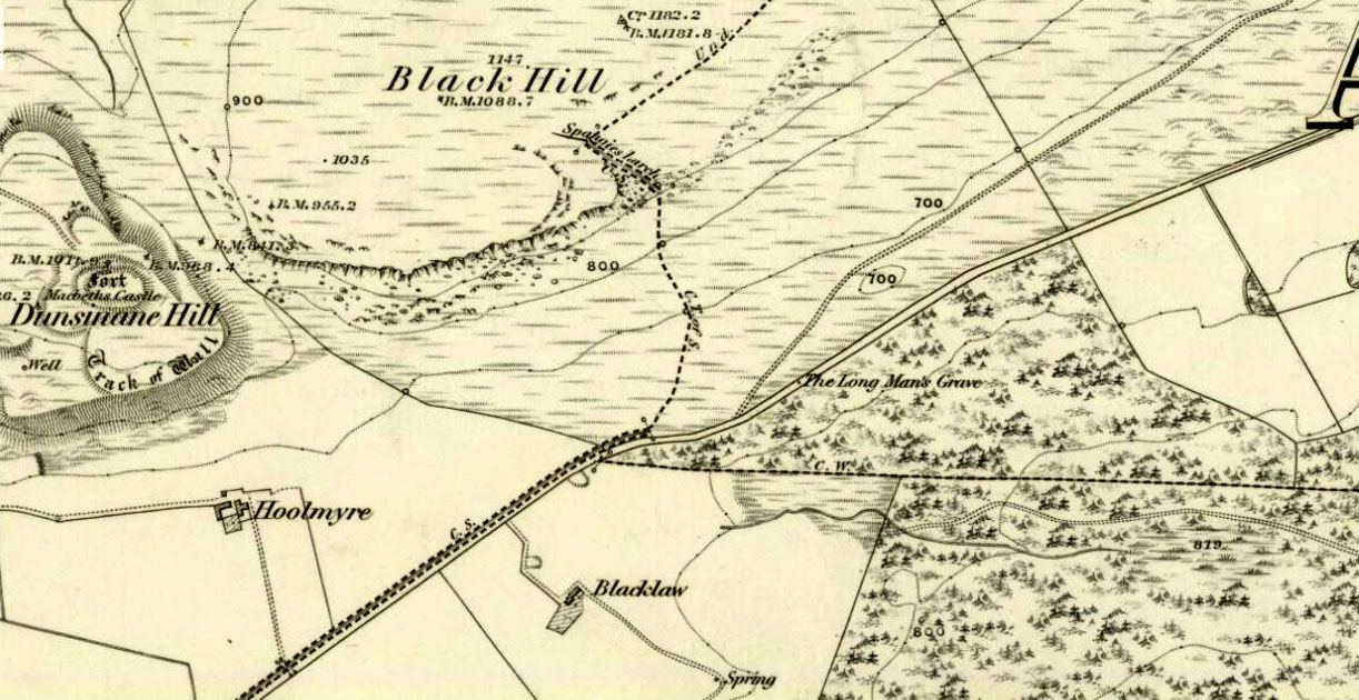
A little-known, but once important site in the mythic history of Scotland, this Long Man’s Grave was said to be the spot where MacBeth—described by Aitchison (1999) as “Scotland’s foremost King”—died. It would seem that any remains of the stone which once stood here has gone. When Robert Chambers (1827) told of the site, he said that
“At the bottom of Dunsinnan Hill, on the east side, and near the west end of a drystone wall which runs along the side of the road from Baledgarno, is a large stone about eight feet in length, beneath which MacBeth is said to have been interred. It is usually called the Lang Man’s Graff, probably from a supposition that the stone was made to suit the length of the deceased.”
More than fifty years later when the Scottish historian Thomas Hunter (1883) wrote about the site, he thought that it had probably been a prehistoric one, telling that
“The tumulus, on being examined, proved to be a druidical stone that had toppled over, and no relic was discovered that could throw light on the tradition.”
Long Man’s Grave on 1867 6-inch map
Site of the Long Mans Grave
The site was shown on the earliest OS-maps of the region (as highlighted here), but we don’t know for certain about the exact nature of the site. Although a bunch of lads from the Royal Commission popped along to see the place in 1969 and proclaimed (without excavation) that the stone was “probably a ‘grave slab’ and not a “standing stone” which has toppled over”, we have to treat their words with caution. Close by are the remains of Bronze Age stone circles; above us we have the prehistoric hillfort of Dunsinane, with even older neolithic remains being found within it; and we also have neolithic rock art remains nearby; other prehistoric tombs, and plenty more besides…
Folklore
Echoing the early folklore of the site as narrated by local people, Hunter (1883) told that,
“the tradition of the district is that MacBeth, finding it impossible to escape from MacDuff, threw himself from the top of the (Dunsinane) Hill, was killed upon the rocks, and buried at the ‘Lang Man’s Grave’.”
References:
Aitchison, Nick, MacBeth – Man and Myth, Sutton: Stroud 1999.
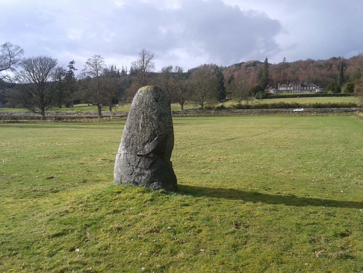
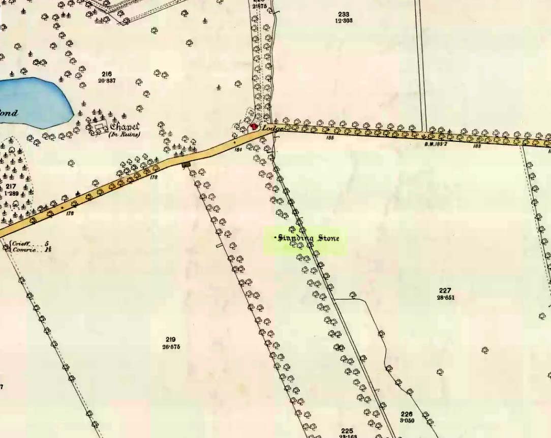
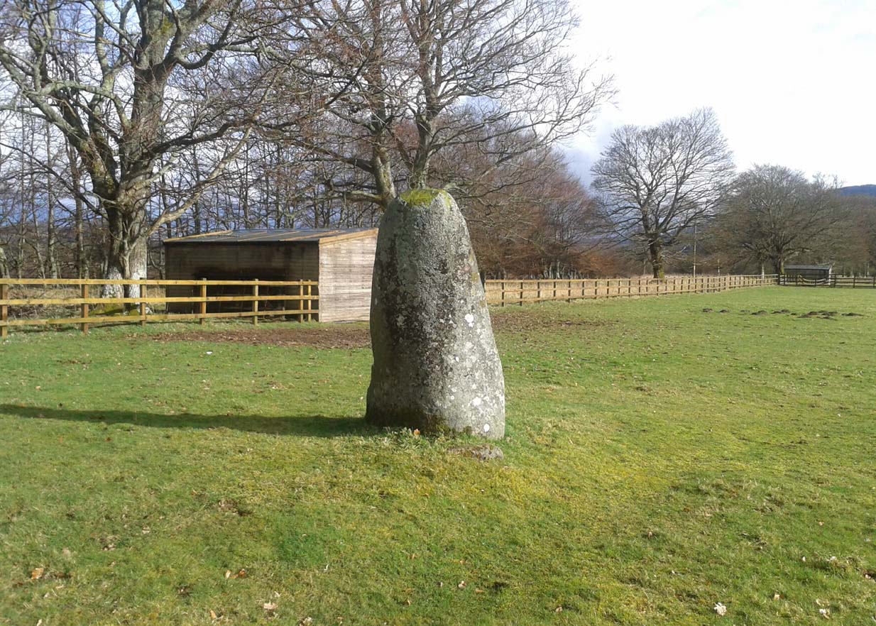
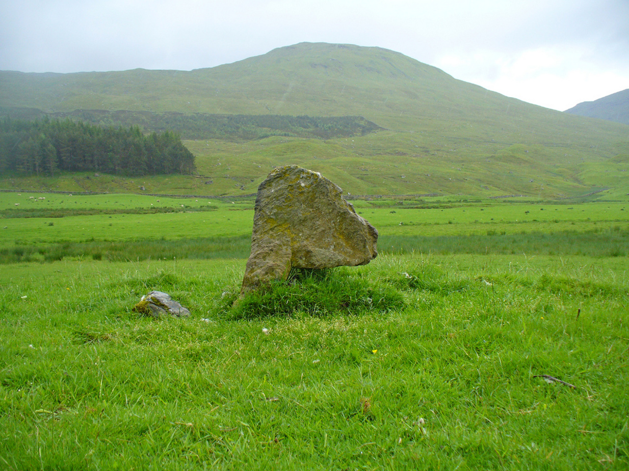
Take the A85 road between Comrie and Crieff. Nearly 1.7 miles (2.7km) east out of Comrie—or 4 miles (6.44km) west out of Crieff—keep your eyes peeled on the fields to the south-side of the road, below and across the mansion of Lawers House. Alongside a long but small plantation of trees you’ll see a large upright stone. You can walk along the track adjacent to the field and through the gate.
Archaeology & History
The stone on 1886 OS-map
Shown on the early Ordnance Survey maps of the area, this probably neolithic monolith was suggested by Fred Coles (1911) to have once been part of a larger megalithic circle—although Aubrey Burl (2000) didn’t consider it as a good enough contender to be listed as such in his gazetteer; and unless we can have some positive affirmation, either through folklore or excavation, we should maintain its status as a singular monolith. There is the possibility that it stood as an outlier or had some relationship with a nearby prehistoric tomb—but even this is contentious. Nevertheless, the stone itself is an impressive one!
Mr Coles curiously got the size of the old stone wrong too (although, we have to give him credit, as he did all of his work without electricity or any of our modern ‘stuff’). He wrote that:
“This massive boulder of whinstone is rounded at the base, where it girths 10 feet 3 inches, but tapers upwards to its apex of 5 feet 10 inches, with the eastern edge somewhat jagged and broken. Near its base on the west is a small slab-like fragment of stone, quite earthfast. The north and south surfaces are smooth and nearly vertical, and the longer axis is ESE 75º by WNW 75º.”
Fred Coles’ 1911 sketch
Lawers monolith, looking SE
The stone is actually larger than Coles described, being more than 6 feet 6 inches tall. His sketch (right) “shows the stone from the east”, and is pretty much as we find it today. A notable crack in the stone along the southern face, about a third of the way up, suggests that the stone was broken at some time in the past.
Local architect Andrew Finlayson (2010) included the stone in his local megalith guide and noted how the axes of the stone, east-west, lines it up with Ben Halton to the west and The Knock to the east.
References:
Burl, Aubrey, The Stone Circles of Britain, Ireland and Brittany, Yale University Press 2000.
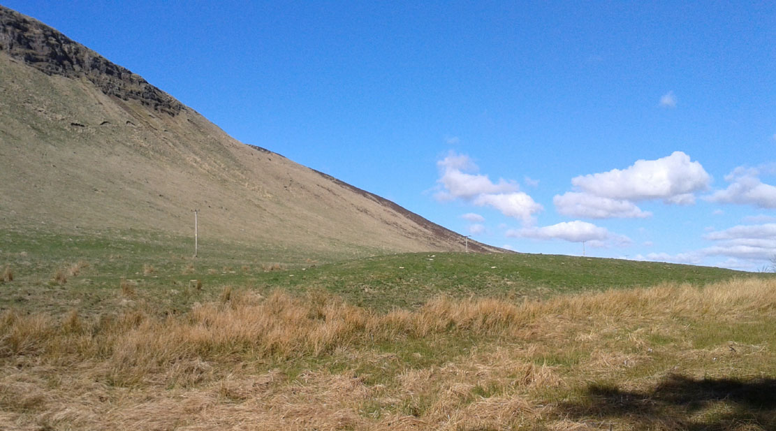
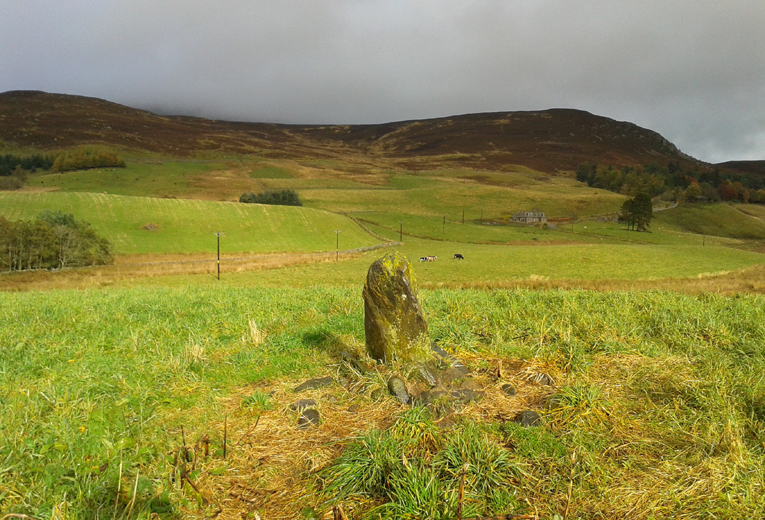
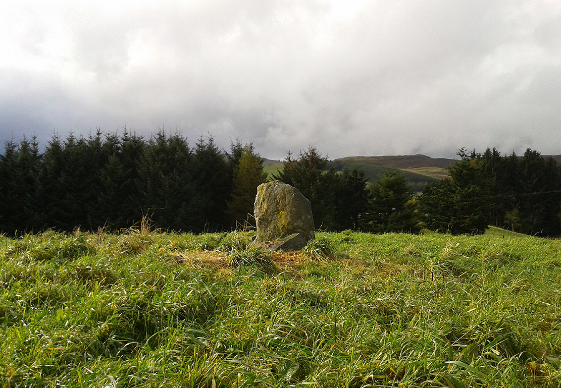
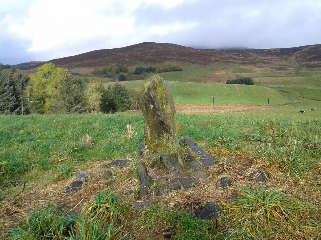
Take the B934 road south, uphill, out of Dunning, for 2.1 miles (3.4km), past Kippen, past Pitmeadow and past Quilts. It’s the track to Knowes that you’re after! Along this track, keep to the field-side on your right, following the edge of the fencing until you reach the small copse of trees. At the far side of the trees a gate takes you into the field with the standing stone, which is just over 100 yards to the north. You can’t miss it!
Archaeology & History
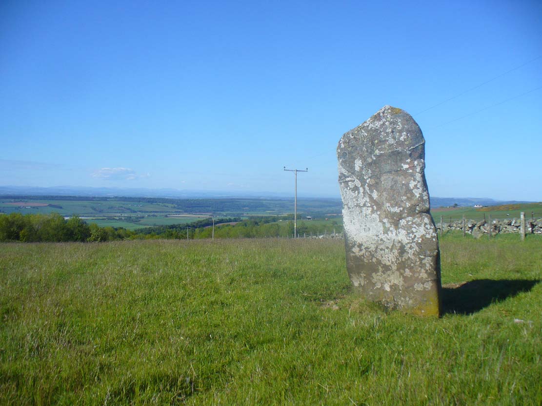
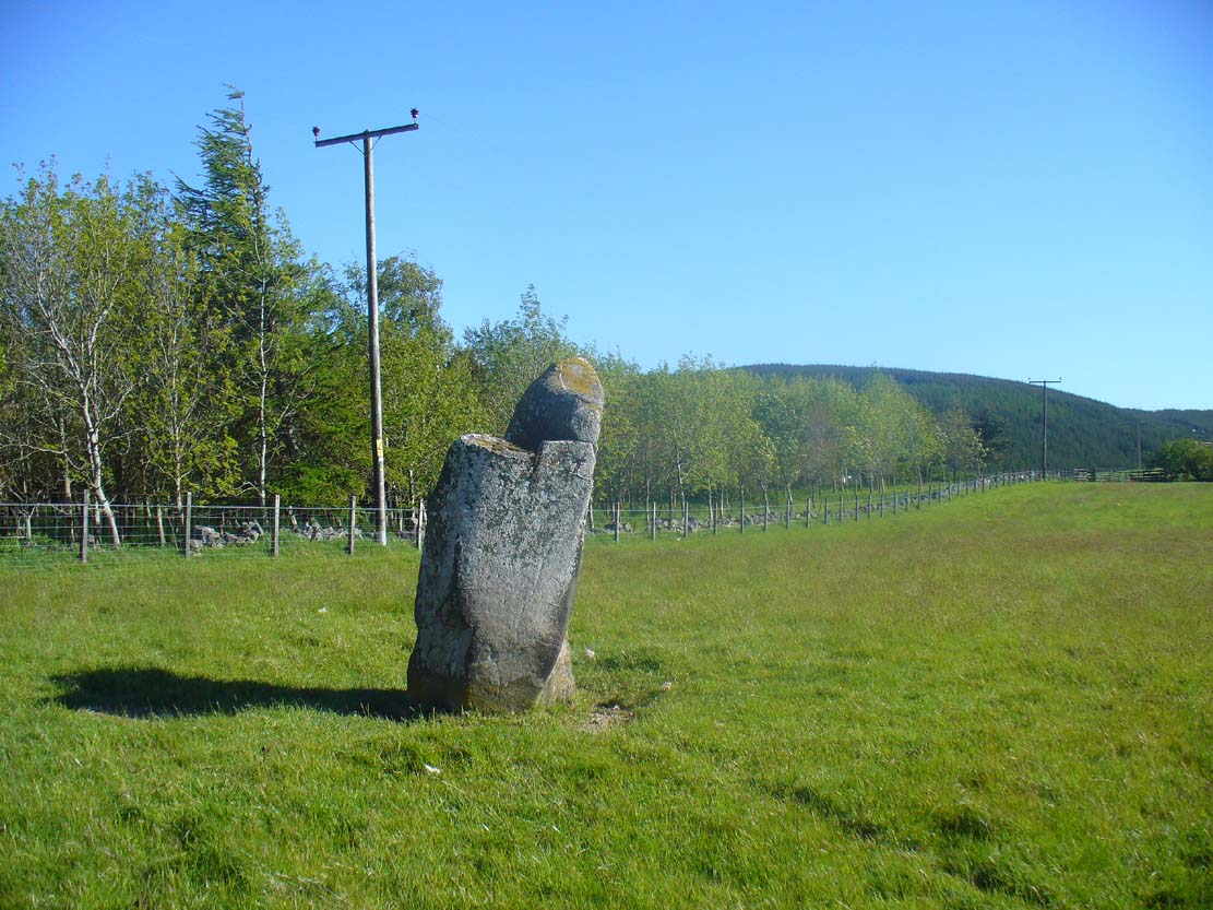
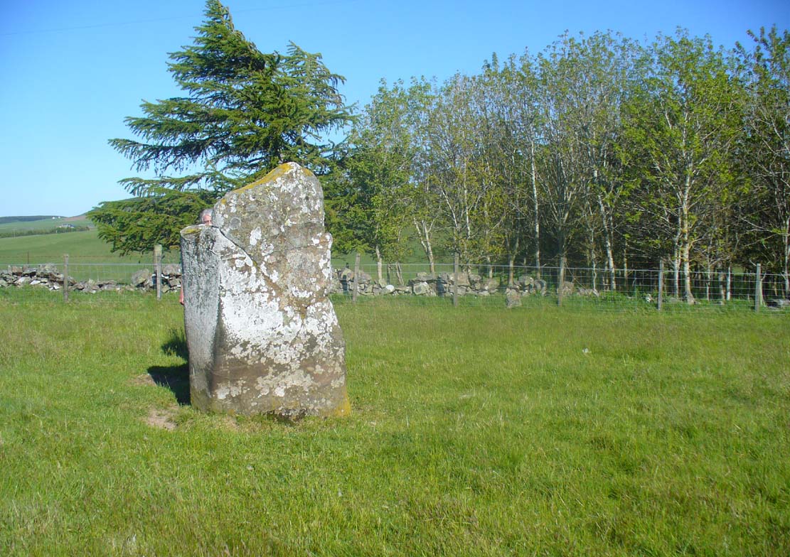
Although mentioned in several folklore works and just a couple of archaeology tomes, almost nothing has been written about this large upright standing stone. A very bulky stone nearly seven feet tall, it has been broken into pieces at sometime in the recent past but, thankfully, good locals put the stone back together and placed it upright once again. Its position in the landscape is quite superb, overlooking the lowlands of Tayside below and then far into the rising mountains of Perthshire and beyond, easy fifty miles or more.
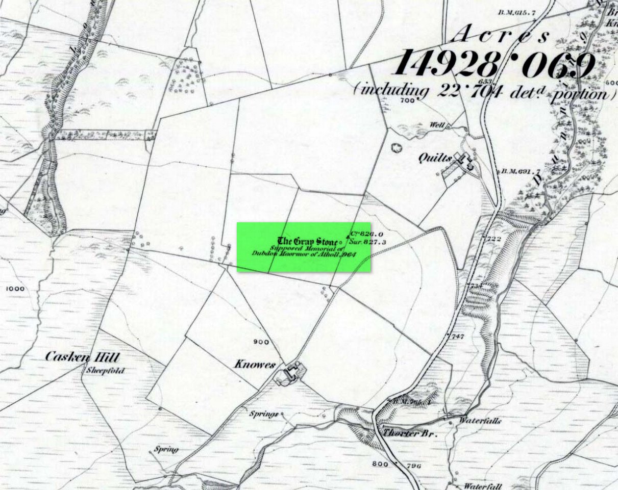
Grey Stone, looking southGray Stone on 1866 map
Shown on the earliest Ordnance Survey map of the area, the name of the stone is somewhat of a puzzle, for in a lot of cases ‘gray’ stones are found on local boundary lines—indeed, the name gray stone and boundary stone are interchangeable in many cases—yet the nearest boundary from here is some distance to the east. It may simply relate to the colour of the rock (although this is unlikely). Whatever its reason, it’s an impressive stone and is well worth checking out!
Folklore
Gray Stone, looking east
The local farmer told that the field where the Grey Stone lives was known as the Big Stane Field. Makes sense! Legend has it that the Gray Stone was the burial place of Maormor, the Steward of Atholl in the Battle of Duncrub, after dying in Thanes Field (Watson 1995), on land to the north of Dunning village in 964-5 CE.
References:
Holder, Geoff, The Guide to Mysterious Perthshire, History Press 2006.
McKerracher, Archie, Perthshire in History and Legend, John Donald: Edinburgh 1988.
Swarbrick, Olaf, A Gazetteer of Prehistoric Standing Stones in Great Britain, BAR: Oxford 2012.
Watson, Angus, The Ochils: Placenames, History, Tradition, PKDC: Perth 1995.
Along the A84 Callander road, just going out on the east side of town, take the signposted road up and up and towards the car-park for the Bracklinn Falls. Another mile past here, keep your eyes peeled for the Wishing Well sign on the right-hand side of the road. From here, walk straight up the hillside for 150 yards (137m) and zigzag about. You’ll see it!
Archaeology & History
This small standing stone (not previously recorded) hides away up on the hillside not far from the old Tobhar na Cailleach (nowadays demoted as a just a Wishing Well), with its history and traditions seemingly long forgotten. About 3 feet high and barely a foot thick, it may once have had a companion standing just a few yards away by its side, where now lays a moss-covered stone. It reminded me a little of the stone pairing called the Cuckoo Stones near Wuthering Heights at Haworth, West Yorkshire.
Possible fallen stone
Druim Mor stone, looking N
Slightly higher up the grassy slope, 15-20 yards away, we find a low line of ancient walling that runs slightly uphill and then across a slightly level piece of land for about 40 yards, before turning back down the hillside and towards the road below.
Folklore
Although we have no recorded traditions of this stone, it needs to be highlighted that the waters, the woods and the slopes below this stone are dedicated to the Cailleach – the great prima Mater of Scottish and Irish traditional history.
Acknowledgements: Many thanks to Nina Harris and Paul Hornby for their help on the day of this find.
Going north-eastish from the city of Perth, take either the A93 or A94, turning west along the A93 a mile south of Guildtown, or east at Balbeggie on the A94, until you reach St. Martin’s hamlet and park up just below the church opposite the old cottages. Walk up the track below the cottages (not the one above them!) for ⅘-mile (1.35km) [past the ruined Cupar Stone Circle], and where the land has levelled out and in the huge flat field on your left, you’ll eventually reach a gate and see the odd-looking ‘rock’ about 250 yards away in the middle.
Archaeology & History
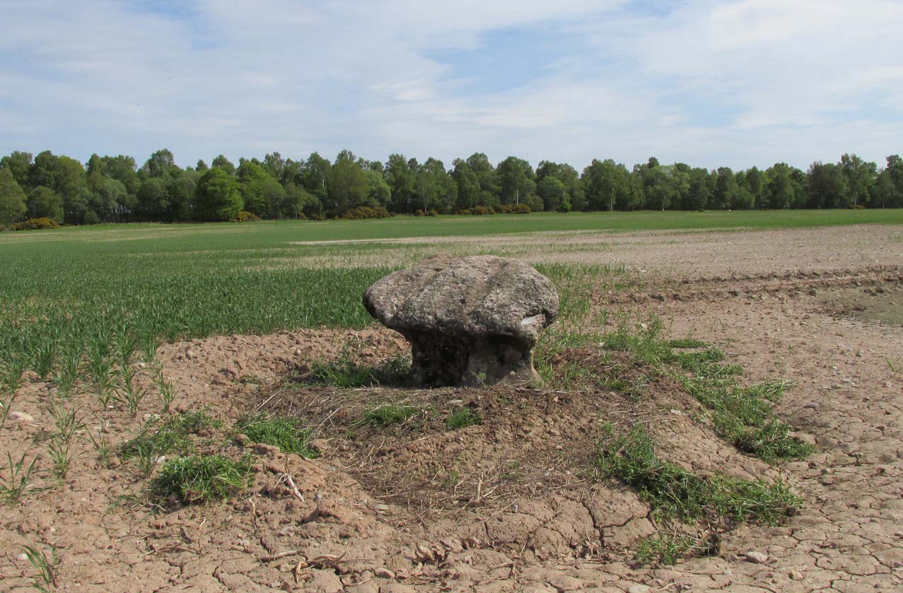
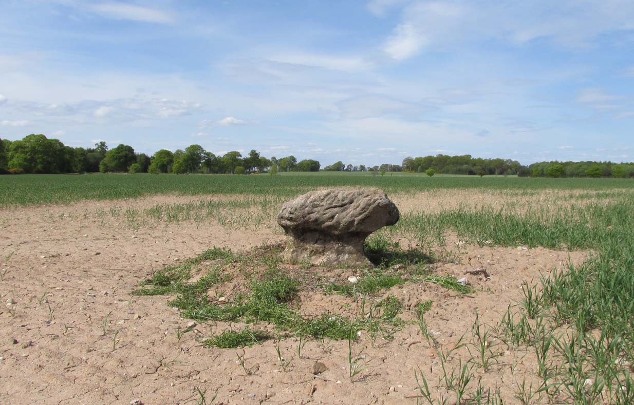
A fungal morel turned to stone
In a quiet and little-known parish that was once littered with about a dozen stone circles, there remains a most curious and fascinating stone which, in earlier days, was to be seen on the open moorlands at this spot. The area was then forested and then the agriculturalists came with their farming and destroyed the forests, leaving the old stone as it presently stands, isolated, above the hamlet of St. Martin’s to the south. Although it was described in the 19th century as being “four feet high”, it stands barely three feet tall, is very curiously-shaped—just like a morel mushroom from some angles—and in the middle of an extensive piece of flatland where the crops barely grow.
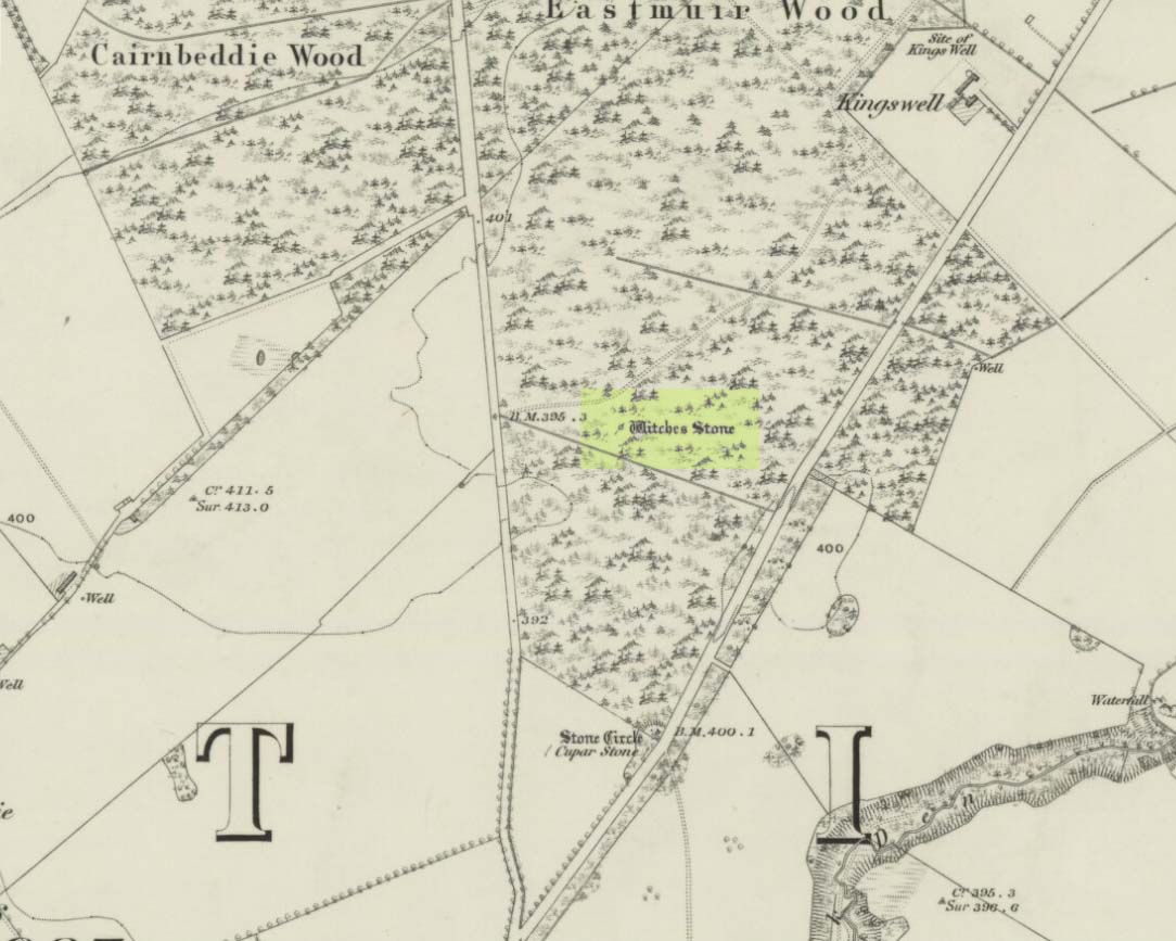
Witches Stone on 1866 map
Witches Stone, looking west
The stone was highlighted on the first OS-map of the parish in 1866, showing it in the woodland plantation of Eastmuir. It may have been some sort of northern outlier related to the now-destroyed stone circle of Cupar 400 yards south; and if this was the case, its position in the landscape relative to the circle would give the Witches Stone an airt (virtue ascribed to cardinal directions) in the cycle of the year that relates to darkness and death. (Perhaps oddly—perhaps not—the name of parish St. Martin’s relates to that dark period in the calendar, as St. Martin’s day in the old calendar was Samhain or Halloween: old New Year’s Day, when the spirits of the dead moved across both land and skies.)
It was erroneously described by the Canmore lads as being little more than “a glacial erratic”, but the stone here is quite earthfast; and their idea that “its peculiar shape has probably been caused by wind erosion”, is also somewhat dubious considering the shape of other monoliths and megalithic rings in the region. The stone has an appearance similar to some Bull Stones, where the animal was chained to rocks such as this and then baited by dogs, although I can find no such lore here. Indeed, the history and archaeology of the stone seems all but silent. Its folklore however, would have the Shakespearian romanciers amongst you flocking to the place…
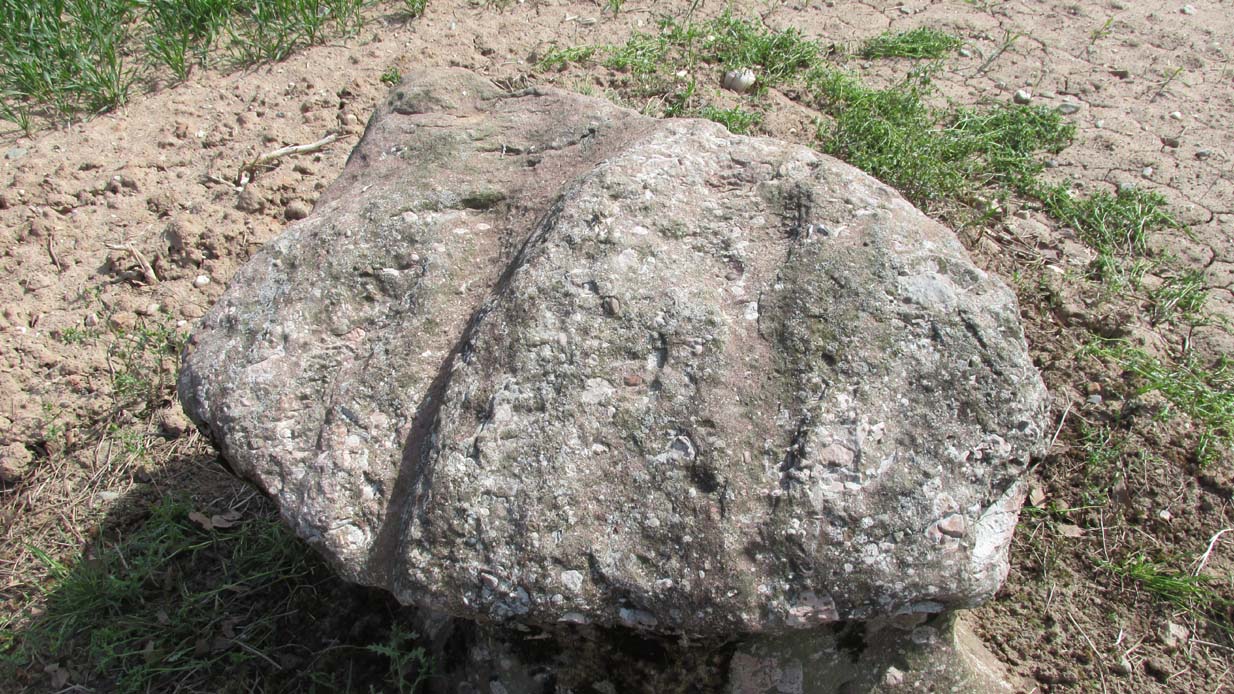
Deep grooves atop of the stone
The top of the stone has some very distinct and deep-cut lines running across it at angles, and has the appearance of being cut into at some time in the dim and distant past. By whom, and for what reason, we cannot say.
Folklore
William Richie (1845) told us that in the 11th Century when Scotland was having to deal with the english disease of stealing land and spreading its violence, King MacBeth—whose castle stood within this parish at Cairnbeddie (NO 1498 3082)—took that advice of two witches, and that
“they met him one night at a place still called ‘the Witch Stane’ (where a remarkable stone still stands), about a mile from his old residence, and warned him to beware, ‘Till Birnam forest come to Dunsinane.’”
The 1860 Name Book told us that,
“The Moor where the witches met, which is in St. Martins Parish is yet pointed out by the country people, and there is a stone still preserved, which is called the Witches Stone.”
References:
Scott, Aleander, St. Martin’s and Cambusmichael, Perth 1911.
Richie, William, “St. Martins and Cambusmichael,” in New Statistical Account of Scotland – volume 10: Perthshire, William Blackwood: Edinburgh 1845.
Acknowledgements: Huge thanks to Prof Paul Hornby for showing me this site. Cheers matey!
In a discussion about the ancient chapel to St. Eonan (the local name in these parts for Adamnan) that once existed near the Bridge of Balgie in Glen Lyon, the local historian Duncan Campbell (1886) informed us that,
“St. Eonan built his chapel near the only stone circle in Glenlyon. The stones of this circle have been removed within my memory. The place is called Clachaig.”
The same writer (Campbell 1888) later told how its remains were still visible around 1848 CE. Campbell’s (1910) later memoirs also mentioned his childhood recollections when the stone circle was in situ, telling that the
“place above the churchyard to Clachaig, named so, the Place of Stones, (was) because the old Druidic stone circle was there.”
We don’t know exactly where the megalithic ring stood; and although modern analysts think the site may have been underneath the invading forestry commission plantation, local lore puts it closer to the graveyard above Kerrowmore.
Enhanced image of curious near-circular form close by
A local dowser thinks that the upright slab in the graveyard at Kerrowmore may be the one remaining stone left here after the circle’s destruction. A quick meander back and forth on a rainy day here, on the geological ridge at the back (south) of Kerrowmore, found only a curious near-circular earthwork that might have been the original site, but it may be fortuitous. A nearby rock outcrop known as “Coill a’ Bhaird” may have been related to the circle.
Folklore
A local man (thanks Tom) said how tradition tells that some of the stones from this circle were taken and used in making the drive to Meggernie Castle last century.
From Blairgowrie, take the A93 north road, ensuring that when you reach the Bridge of Cally after 5½ miles (9km), you take the right-turn up Glenshee (the Valley of the Faerie folk) and not the A924 Strathardle road. After about 5 miles, turn right up the small lane to Blacklunans after, once you’ve weaved past the River Shee and started uphill, a few hundred yards on keep yer eyes peeled on the fields to your left. If you hit the Glenshee EcoCamp, you’ve gone too far.
Archaeology & History
Borland Stone, looking west
This small, out-of-the-way standing stone is set amidst a small mass of rounded stones—as if once part of a cairn—at the top of a small hillock that can easily be passed by if your nose isn’t working properly. Curiously isolated, the monolith seems more of an outlier to the Mount Blair hills immediately north and east; or perhaps the large settlement less than a mile south.
Very little seems to have been said about the stone, in literary terms at least. The Royal Commission (1990) lads merely told us that,
“This stone, which stands on the summit of a prominent knoll 300m SE of Borland farmhouse, measures 0.7m by 0.3m at the base and 1m in height.”
Stone aligned NNE to Tom Bealaidh
Nowt else! Although the stone was marked on the early 1900 OS-map, the small mass of loose stones at its base are more recently-worked than anything prehistoric and may simply be field clearance. The monolith itself could do with assessment to positively ensure its prehistoric veracity.
References:
Meikle, James, Places and Place-Names around Alyth, Alexander Gardner: Paisley 1925.
Royal Commission on the Ancient & Historical Monuments of Scotland, North-East Perth: An Archaeological Landscape, HMSO: Edinburgh 1990.
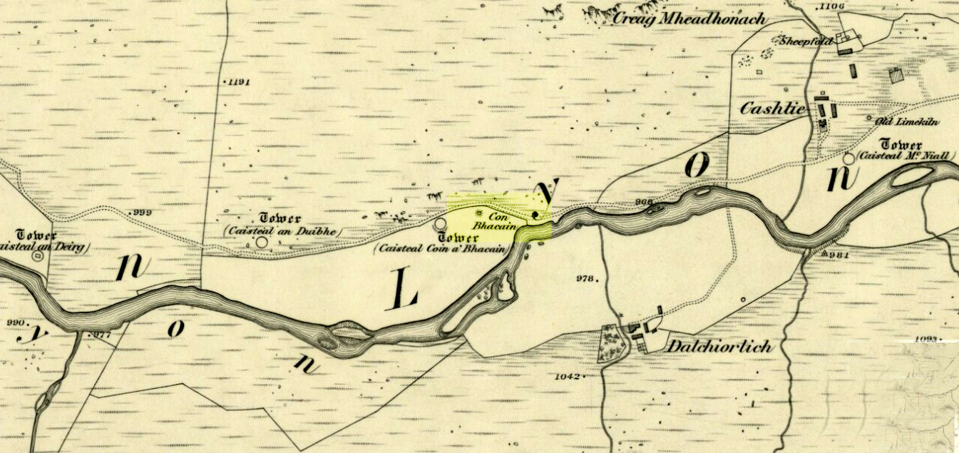
Whether you take the road west from Fortingall, or over the heights from Loch Tay, when you reach Meggernie Castle just keep going west for a few more miles. Keep going past the large Stronuich reservoir on your left and you’re getting close. Go past Caisteal Mhic Neill and the trees at Cashlie House for another 5-600 yards and where the track crosses the river Lyon, park up just past it. Ahead of you in the field on the left of the road, nearer the riverside, is where you need to look.
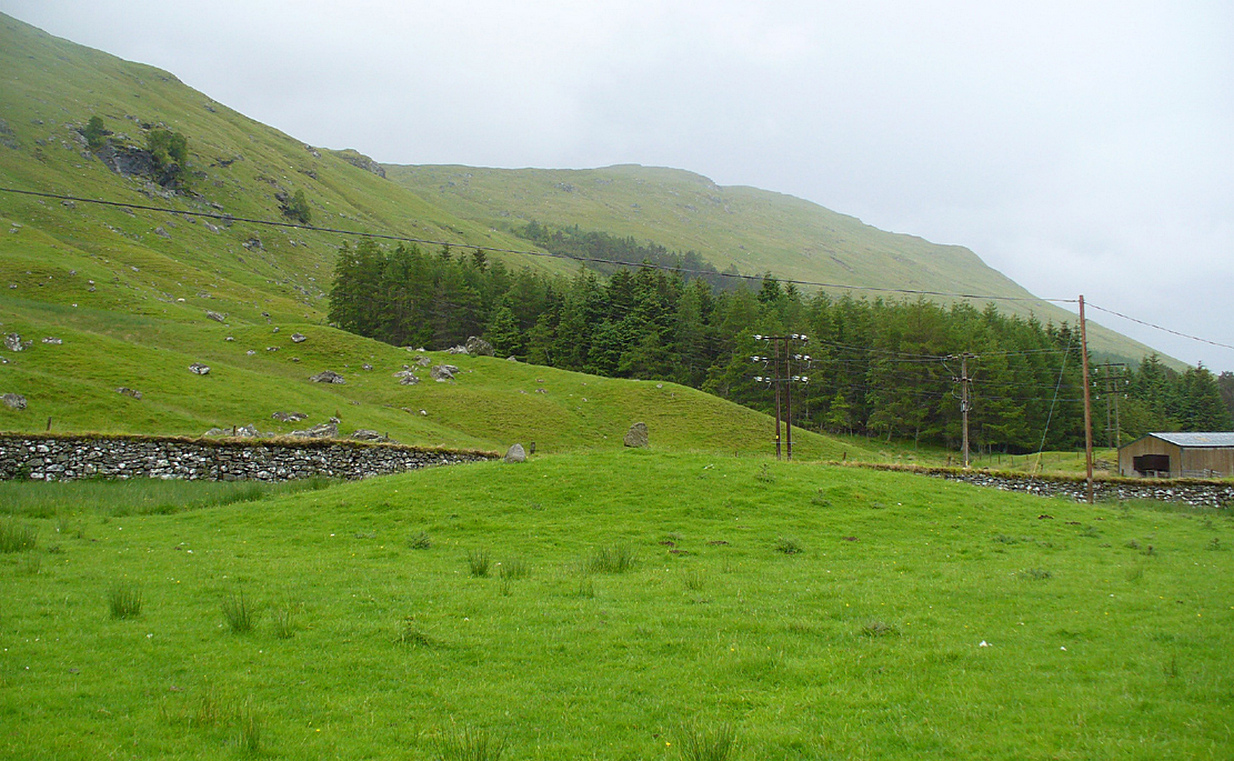
Archaeology & History
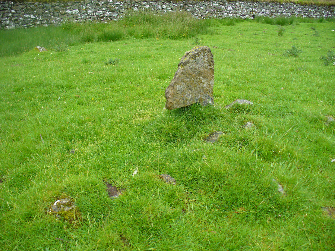
One of the most peculiar and unique sites in the British Isles is this remote small upright stone, known locally as The Bhacain. Standing upon a small mound in the field immediately east of one of Finn’s legendary ‘forts’ (a dun or a broch) called Caisteal Cona Bhacain, this curious monolith, less than two feet tall, has a thin upright stem with a much enlarged rounded end to it. Some might even ascribe it as phallic—although local traditions of the stone relate it as a truth-sayer of a young girl’s virginity!
The Bhacain on 1867 mapMound of The Bhacain
Its position on top of the small mound is intriguing, giving it the impression of being atop of a tumulus; and there is also the scatter of small stones surrounding the upright just beneath the surface (as evidenced in one of the photos), making it possible that the stone is an ancient burial marker. If this is ever shown to be true, the likelihood is that the stone marks the grave of a hound, as the tradition of this spot implies. No excavation has ever occurred here, so the precise nature of the stone (and the mound) has yet to be ascertained; but knowing the longevity of some oral traditions in these Highland glens, the idea of it being the burial-place of a dog is anything but far-fetched.
If the stone is contemporaneous with the associated ‘duns’ close by, this would be a late standing stone, probably erected in the Iron Age. We can certainly see, quite plainly from the erosion on the stone, that this is not neolithic or Bronze Age in origin. A decent examination of the important sites hereby is long overdue…
Folklore
The Bhacain & its stony pile
The folklore and traditions attached to this site are numerous when you consider how small it is. Much of this relates to the fact that animistic cosmologies in the Highlands were retained until very recently, stretching way back. Accounts from the 19th and 20th centuries tell of people still frequenting this and other sites, at sunrise, or full moons, as such things were still very much integral parts of rural life. When the local historian Duncan Fraser (1973) wrote about The Bhacain in his fine work on this area, he told much about the traditions of the great warrior King Fionn and his activities hereby:
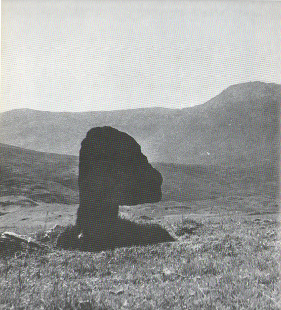
Duncan Fraser’s old photoThe Bhacain, looking S
“Another traditional link with the warrior King is the Bhacain, on a mound beside the road, far up the glen. Only a stone’s throw from one of the forts, it is about two feet high and shaped like the head of a dog. This is said to have been the stake to which the Fians tethered their staghounds with leather thongs, when they returned from the chase. And there were times, no doubt, when Fionn’s own dog, Bran was among them, with its yellow paws and its black flanks and its chain of pure gold. It was the best hunting dog that ever lived. And there was its brother, the dreaded Grey Hound, that used to roam on its own in the Great Glen, tearing its victims limb from limb, until it too abandoned its wildness and became one of the hounds of the Fians. They say that the dogs’ food was thrown to them from the top of Caisteal Coin-a-bhacain, the castle of the dog’s stake, upwards of seventy yards to the west. And any dog that failed to catch its supper was turned out of the pack.
“Time did not allow the Bhacain to become inanimate like other stones. Even in comparatively recent times it was still regarded with superstitious awe. A retired schoolmaster of Fortingall recorded eighty years ago that it was said to have a mysterious effect on those who crept under its head. And old folk in the glen will tell you that those who did so were girls. It had become the glen folk’s yardstick of virginity. In the late eighteenth century, when the girls returned from gathering the harvest in the ungodly Lowlands, under the stone they went. It was better than all your modern pills.”
In Hilary Wheater’s (1981) fine work on the history of the region, he told that “no youth was permitted into the fighting body of the Clan until he could lift the Bodach Stone onto the boulder beside it.” This tradition gave the Bhacain another name, the Testing Stone of the Fianna.
References:
Burke, Peter, Popular Culture in Early Modern Europe, Scolar Press: Aldershot 1994.
Fraser, Duncan, Highland Perthshire, Standard Press: Montrose 1973.
McKerracher, Archie, Perthshire in History and Legend, John Donald: Edinburgh 1988.
Stewart, Alexander, A Highland Parish; or, The History of Fortingall, Alex MacLaren: Glasgow 1928.
Wheater, Hilary, Aberfeldy to Glenlyon, Appin Publications: Aberfeldy 1981.